

Geography of São Tomé and Príncipe
Encyclopedia
São Tomé and Príncipe
São Tomé and Príncipe, officially the Democratic Republic of São Tomé and Príncipe, is a Portuguese-speaking island nation in the Gulf of Guinea, off the western equatorial coast of Central Africa. It consists of two islands: São Tomé and Príncipe, located about apart and about , respectively, off...
is a small nation composed of an archipelago
Archipelago
An archipelago , sometimes called an island group, is a chain or cluster of islands. The word archipelago is derived from the Greek ἄρχι- – arkhi- and πέλαγος – pélagos through the Italian arcipelago...
located in the Gulf of Guinea
Gulf of Guinea
The Gulf of Guinea is the northeasternmost part of the tropical Atlantic Ocean between Cape Lopez in Gabon, north and west to Cape Palmas in Liberia. The intersection of the Equator and Prime Meridian is in the gulf....
of equator
Equator
An equator is the intersection of a sphere's surface with the plane perpendicular to the sphere's axis of rotation and containing the sphere's center of mass....
ial Atlantic Ocean
Atlantic Ocean
The Atlantic Ocean is the second-largest of the world's oceanic divisions. With a total area of about , it covers approximately 20% of the Earth's surface and about 26% of its water surface area...
. The nation's main islands are São Tomé
São Tomé
-Transport:São Tomé is served by São Tomé International Airport with regular flights to Europe and other African Countries.-Climate:São Tomé features a tropical wet and dry climate with a relatively lengthy wet season and a short dry season. The wet season runs from October through May while the...
and Príncipe
Príncipe
Príncipe is the northern and smaller of the two major islands of the country of São Tomé and Príncipe lying off the west coast of Africa. It has an area of 136 km² and a population of approximately 5,000. The island is a heavily eroded volcano over three million years old, surrounded by other...
, for which the country is named. These are located about 300 and 250 km (186.4 and 155.3 mi), respectively, off the northwest coast of Gabon
Gabon
Gabon , officially the Gabonese Republic is a state in west central Africa sharing borders with Equatorial Guinea to the northwest, Cameroon to the north, and with the Republic of the Congo curving around the east and south. The Gulf of Guinea, an arm of the Atlantic Ocean is to the west...
in West Africa
West Africa
West Africa or Western Africa is the westernmost region of the African continent. Geopolitically, the UN definition of Western Africa includes the following 16 countries and an area of approximately 5 million square km:-Flags of West Africa:...
. The nation's geographic coordinates are a latitude
Latitude
In geography, the latitude of a location on the Earth is the angular distance of that location south or north of the Equator. The latitude is an angle, and is usually measured in degrees . The equator has a latitude of 0°, the North pole has a latitude of 90° north , and the South pole has a...
of 1°00′N and a longitude
Longitude
Longitude is a geographic coordinate that specifies the east-west position of a point on the Earth's surface. It is an angular measurement, usually expressed in degrees, minutes and seconds, and denoted by the Greek letter lambda ....
of 7°00′E.
São Tomé and Príncipe constitute one of Africa
Africa
Africa is the world's second largest and second most populous continent, after Asia. At about 30.2 million km² including adjacent islands, it covers 6% of the Earth's total surface area and 20.4% of the total land area...
's smallest countries, with a 209 km (130 mi) of coastline. Both are part of an extinct volcanic
Volcano
2. Bedrock3. Conduit 4. Base5. Sill6. Dike7. Layers of ash emitted by the volcano8. Flank| 9. Layers of lava emitted by the volcano10. Throat11. Parasitic cone12. Lava flow13. Vent14. Crater15...
mountain range
Mountain range
A mountain range is a single, large mass consisting of a succession of mountains or narrowly spaced mountain ridges, with or without peaks, closely related in position, direction, formation, and age; a component part of a mountain system or of a mountain chain...
, which also includes the island of Bioko
Bioko
Bioko is an island 32 km off the west coast of Africa, specifically Cameroon, in the Gulf of Guinea. It is the northernmost part of Equatorial Guinea with a population of 124,000 and an area of . It is volcanic with its highest peak the Pico Basile at .-Geography:Bioko has a total area of...
in Equatorial Guinea
Equatorial Guinea
Equatorial Guinea, officially the Republic of Equatorial Guinea where the capital Malabo is situated.Annobón is the southernmost island of Equatorial Guinea and is situated just south of the equator. Bioko island is the northernmost point of Equatorial Guinea. Between the two islands and to the...
to the north and Mount Cameroon
Mount Cameroon
Mount Cameroon is an active volcano in Cameroon near the Gulf of Guinea. Mount Cameroon is also known as Cameroon Mountain or Fako or by its native name Mongo ma Ndemi ....
to the west. São Tomé is 50 km (31.1 mi) long and 30 km (18.6 mi) wide and the more mountain
Mountain
Image:Himalaya_annotated.jpg|thumb|right|The Himalayan mountain range with Mount Everestrect 58 14 160 49 Chomo Lonzorect 200 28 335 52 Makalurect 378 24 566 45 Mount Everestrect 188 581 920 656 Tibetan Plateaurect 250 406 340 427 Rong River...
ous of the two islands. Its peaks reach 2024 m (6,640 ft) - Pico de São Tomé
Pico de São Tomé
Pico de São Tomé is the highest mountain in São Tomé and Príncipe at 2,024 metres. It lies just west of the centre of São Tomé Island in the Obo National Park. The second highest point, Pico Ana Chaves, lies to its south east...
. Principe is about 30 km (19 mi) long and 6 km (4 mi) wide, making it the smaller of the two. Its peaks reach 948 m (3,110 ft) - Pico de Príncipe
Pico de Príncipe
Pico de Príncipe is a mountain on the island of Príncipe, the smaller of the two inhabited islands of São Tomé and Príncipe. The elevation of the mountain is generally given as , making it the highest peak on the island, but a trip to the peak in 1999 found that it may be lower than that, making...
. This makes the total land area of the country 1001 square kilometre, about five times the size of Washington, D.C.
Washington, D.C.
Washington, D.C., formally the District of Columbia and commonly referred to as Washington, "the District", or simply D.C., is the capital of the United States. On July 16, 1790, the United States Congress approved the creation of a permanent national capital as permitted by the U.S. Constitution....
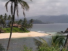
. Both islands are crossed by swift streams radiating down the mountains through lush forest and cropland to the sea. Both islands at a distance of 150 square kilometre. The equator lies immediately south of São Tomé Island, passing through an islet Ilhéu das Rolas
Ilhéu das Rolas
Ilhéu das Rolas is a small island in São Tomé and Príncipe, in Africa. The island lies on the equator, off the southern tip of São Tomé Island. It is in the Caué District of São Tomé Province. The island is home to a small resort....
.
The Pico Cão Grande
Pico Cão Grande
The Pico Cão Grande is a landmark needle-shaped volcanic plug peak in São Tomé and Príncipe, located in the south of the island of São Tomé in Obo National Park. It rises dramatically over 300 m above the surrounding terrain and the summit is 663 m above sea level.-References:...
(Great Dog Peak) is a landmark volcanic plug
Volcanic plug
A volcanic plug, also called a volcanic neck or lava neck, is a volcanic landform created when magma hardens within a vent on an active volcano. When forming, a plug can cause an extreme build-up of pressure if volatile-charged magma is trapped beneath it, and this can sometimes lead to an...
peak, located at 0°7′0"N 6°34′00"E in southern São Tomé. It rises dramatically over 300 m (984.3 ft) above the surrounding terrain and the summit is 663 m (2,175 ft) above sea level.
Climate
At sea levelSea level
Mean sea level is a measure of the average height of the ocean's surface ; used as a standard in reckoning land elevation...
, the climate is tropical—hot and humid with average yearly temperatures of about 27 °C (80.6 °F) and little daily variation. At the interior's higher altitudes, the average yearly temperature is 20 °C (68 °F), and nights are generally cool. Annual rainfall varies from 5000 mm (196.9 in) on the southwestern slopes to 1000 mm (39.4 in) in the northern lowlands. The rainy season runs from October to May.
Wildlife
The two islands are oceanic islands which have always been separate from mainland West Africa and so there is a relatively low diversity of species, restricted to those that have managed to cross the sea to the islands. However the level of endemism is high with many species occurring nowhere else in the world.Statistics
Maritime claims:- Measured from claimed archipelagic baselines
- Exclusive economic zone: 200 nmi (370.4 km; 230.2 mi)
- Territorial sea: 12 nmi (22.2 km; 13.8 mi)
Climate:
- Tropical; hot, humid; one rainy season (October to May)
Terrain:
- Volcanic, mountainous
Elevation extremes:
- Lowest point: Atlantic Ocean 0 m (0 ft)
Natural resources:
- FishFishFish are a paraphyletic group of organisms that consist of all gill-bearing aquatic vertebrate animals that lack limbs with digits. Included in this definition are the living hagfish, lampreys, and cartilaginous and bony fish, as well as various extinct related groups...
, hydropowerHydropowerHydropower, hydraulic power, hydrokinetic power or water power is power that is derived from the force or energy of falling water, which may be harnessed for useful purposes. Since ancient times, hydropower has been used for irrigation and the operation of various mechanical devices, such as...
Natural hazards:
Environment--current issues:
- Deforestation; soil erosion and exhaustion
Environment--international agreements:
- Party to: BiodiversityBiodiversityBiodiversity is the degree of variation of life forms within a given ecosystem, biome, or an entire planet. Biodiversity is a measure of the health of ecosystems. Biodiversity is in part a function of climate. In terrestrial habitats, tropical regions are typically rich whereas polar regions...
, Climate ChangeUnited Nations Framework Convention on Climate ChangeThe United Nations Framework Convention on Climate Change is an international environmental treaty produced at the United Nations Conference on Environment and Development , informally known as the Earth Summit, held in Rio de Janeiro from June 3 to 14, 1992...
, DesertificationDesertificationDesertification is the degradation of land in drylands. Caused by a variety of factors, such as climate change and human activities, desertification is one of the most significant global environmental problems.-Definitions:...
, Environmental Modification, Law of the SeaLaw of the seaLaw of the sea may refer to:* United Nations Convention on the Law of the Sea* Admiralty law* The Custom of the Sea...
, Ship Pollution - Signed, but not ratified: None of the selected agreements
Extreme points
This is a list of the extreme points of São Tomé and PríncipeSão Tomé and Príncipe
São Tomé and Príncipe, officially the Democratic Republic of São Tomé and Príncipe, is a Portuguese-speaking island nation in the Gulf of Guinea, off the western equatorial coast of Central Africa. It consists of two islands: São Tomé and Príncipe, located about apart and about , respectively, off...
, the points that are farther north, south, east or west than any other location.
- Northern-most point - unnamed headland on Ilheu Bom BomIlheu Bom BomIlhéu Bom Bom, also Ilhéu Bombom is an island in the Gulf of Guinea. The islet is located north of the coast of the island of Príncipe, one of the main islands of São Tomé and Príncipe. The island includes a couple of tourist resorts in São Tomé and Príncipe....
- Eastern-most point - Ponta Capitão, PríncipePríncipePríncipe is the northern and smaller of the two major islands of the country of São Tomé and Príncipe lying off the west coast of Africa. It has an area of 136 km² and a population of approximately 5,000. The island is a heavily eroded volcano over three million years old, surrounded by other...
- Southern-most point - unnamed headland on Ilhéu de Rolas
- Western-most point - Ponta Azeitona