

Geography of Swaziland
Encyclopedia

Swaziland
Swaziland, officially the Kingdom of Swaziland , and sometimes called Ngwane or Swatini, is a landlocked country in Southern Africa, bordered to the north, south and west by South Africa, and to the east by Mozambique...
is a country in Southern Africa
Southern Africa
Southern Africa is the southernmost region of the African continent, variably defined by geography or geopolitics. Within the region are numerous territories, including the Republic of South Africa ; nowadays, the simpler term South Africa is generally reserved for the country in English.-UN...
, lying between Mozambique
Mozambique
Mozambique, officially the Republic of Mozambique , is a country in southeastern Africa bordered by the Indian Ocean to the east, Tanzania to the north, Malawi and Zambia to the northwest, Zimbabwe to the west and Swaziland and South Africa to the southwest...
and South Africa
South Africa
The Republic of South Africa is a country in southern Africa. Located at the southern tip of Africa, it is divided into nine provinces, with of coastline on the Atlantic and Indian oceans...
. The country is located at the geographic coordinates 26°30′S 31°30′E. Swaziland
Swaziland
Swaziland, officially the Kingdom of Swaziland , and sometimes called Ngwane or Swatini, is a landlocked country in Southern Africa, bordered to the north, south and west by South Africa, and to the east by Mozambique...
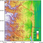
has an area of 17,363 square kilometres, of which 160 are water. The major regions of the country are Lowveld, Midveld and Highveld.
Climate
The climate of Swaziland varies from tropical to near temperateTemperate
In geography, temperate or tepid latitudes of the globe lie between the tropics and the polar circles. The changes in these regions between summer and winter are generally relatively moderate, rather than extreme hot or cold...
.
The seasons are the reverse of those in the Northern Hemisphere with December being mid-summer and June mid-winter. Generally speaking, rain falls mostly during the summer months, often in the form of thunderstorms. Winter is the dry season. Annual rainfall is highest on the Highveld in the West, between 1000 and 2000 mm (39.4 and 78.7 in) depending on the year. The further East, the less rain, with the Lowveld recording 500 to 900 mm (19.7 to 35.4 in) per annum. Variations in temperature are also related to the altitude of the different regions. The Highveld temperature is temperate and, seldom, uncomfortably hot while the Lowveld may record temperatures around 40 °C (104 °F) in summer.
The average temperatures at Mbabane, according to seasons:
| Spring | September – October | 18 °C (64.4 °F) |
| Summer | November – March | 20 °C (68 °F) |
| Autumn | April – May | 17 °C (62.6 °F) |
| Winter | June – August | 13 °C (55.4 °F) |
Physical geography
Mountain
Image:Himalaya_annotated.jpg|thumb|right|The Himalayan mountain range with Mount Everestrect 58 14 160 49 Chomo Lonzorect 200 28 335 52 Makalurect 378 24 566 45 Mount Everestrect 188 581 920 656 Tibetan Plateaurect 250 406 340 427 Rong River...
s and hill
Hill
A hill is a landform that extends above the surrounding terrain. Hills often have a distinct summit, although in areas with scarp/dip topography a hill may refer to a particular section of flat terrain without a massive summit A hill is a landform that extends above the surrounding terrain. Hills...
s, with some moderately sloping plain
Plain
In geography, a plain is land with relatively low relief, that is flat or gently rolling. Prairies and steppes are types of plains, and the archetype for a plain is often thought of as a grassland, but plains in their natural state may also be covered in shrublands, woodland and forest, or...
s. The lowest point is the Great Usutu River, at 21 metres, and the highest is Emlembe
Emlembe
Emlembe is the highest mountain in Swaziland. It is located in the east uKhahlamba mountain range, on the border with South Africa....
, at 1,862 m.
As a landlocked country, Swaziland has neither coastline nor maritime claims. In terms of land boundaries, Swaziland borders Mozambique for 105 kilometres, and South Africa for 430, giving a total land boundary length of 535 km.
Natural resources
Swaziland possesses the following natural resources: asbestosAsbestos
Asbestos is a set of six naturally occurring silicate minerals used commercially for their desirable physical properties. They all have in common their eponymous, asbestiform habit: long, thin fibrous crystals...
, coal
Coal
Coal is a combustible black or brownish-black sedimentary rock usually occurring in rock strata in layers or veins called coal beds or coal seams. The harder forms, such as anthracite coal, can be regarded as metamorphic rock because of later exposure to elevated temperature and pressure...
, clay
Clay
Clay is a general term including many combinations of one or more clay minerals with traces of metal oxides and organic matter. Geologic clay deposits are mostly composed of phyllosilicate minerals containing variable amounts of water trapped in the mineral structure.- Formation :Clay minerals...
, cassiterite
Cassiterite
Cassiterite is a tin oxide mineral, SnO2. It is generally opaque, but it is translucent in thin crystals. Its luster and multiple crystal faces produce a desirable gem...
, hydropower
Hydropower
Hydropower, hydraulic power, hydrokinetic power or water power is power that is derived from the force or energy of falling water, which may be harnessed for useful purposes. Since ancient times, hydropower has been used for irrigation and the operation of various mechanical devices, such as...
, forests, small gold
Gold
Gold is a chemical element with the symbol Au and an atomic number of 79. Gold is a dense, soft, shiny, malleable and ductile metal. Pure gold has a bright yellow color and luster traditionally considered attractive, which it maintains without oxidizing in air or water. Chemically, gold is a...
and diamond
Diamond
In mineralogy, diamond is an allotrope of carbon, where the carbon atoms are arranged in a variation of the face-centered cubic crystal structure called a diamond lattice. Diamond is less stable than graphite, but the conversion rate from diamond to graphite is negligible at ambient conditions...
deposits, quarry stone, and talc
Talc
Talc is a mineral composed of hydrated magnesium silicate with the chemical formula H2Mg34 or Mg3Si4O102. In loose form, it is the widely-used substance known as talcum powder. It occurs as foliated to fibrous masses, its crystals being so rare as to be almost unknown...
670 km² of the country's land is irrigated. The following table describes land use in Swaziland.
| Use | Percentage of Area |
|---|---|
| arable land | 9.77 |
| permanent crops | 0.7 |
| other | 89.53 |
Environment
The kingdom of Swaziland is prone to floods and droughtDrought
A drought is an extended period of months or years when a region notes a deficiency in its water supply. Generally, this occurs when a region receives consistently below average precipitation. It can have a substantial impact on the ecosystem and agriculture of the affected region...
. Soil erosion as a result of overgrazing is a growing problem.
Swaziland is party to the following international agreements: Biodiversity, Climate Change, Endangered Species, Nuclear Test Ban and Ozone Layer Protection. The country has signed, but not ratified the agreement on desertification, and the law of the sea.
Extreme points
This is a list of the extreme points of SwazilandSwaziland
Swaziland, officially the Kingdom of Swaziland , and sometimes called Ngwane or Swatini, is a landlocked country in Southern Africa, bordered to the north, south and west by South Africa, and to the east by Mozambique...
, the points that are farther north, south, east or west than any other location.
- Northern-most point - unnamed location of the border with South Africa immediately north of the village of Horo, Hhohho District
- Eastern-most point - the tripointTripointA tripoint, or trijunction , is a geographical point at which the borders of three countries or subnational entities meet....
with South AfricaSouth AfricaThe Republic of South Africa is a country in southern Africa. Located at the southern tip of Africa, it is divided into nine provinces, with of coastline on the Atlantic and Indian oceans...
and MozambiqueMozambiqueMozambique, officially the Republic of Mozambique , is a country in southeastern Africa bordered by the Indian Ocean to the east, Tanzania to the north, Malawi and Zambia to the northwest, Zimbabwe to the west and Swaziland and South Africa to the southwest...
, Lubombo District - Southern-most point - unnamed location on the border with South AfricaSouth AfricaThe Republic of South Africa is a country in southern Africa. Located at the southern tip of Africa, it is divided into nine provinces, with of coastline on the Atlantic and Indian oceans...
, Shiselweni District - Western-most point - a section of the border with South AfricaSouth AfricaThe Republic of South Africa is a country in southern Africa. Located at the southern tip of Africa, it is divided into nine provinces, with of coastline on the Atlantic and Indian oceans...
, Manzini DistrictManzini DistrictManzini is a district of Swaziland, located in the center-west of the country. It has an area of 5,068 km² and a population of 292,000 , and is divided into 16 tinkhundla. Its administrative center is Manzini. It borders all three other districts: Hhohho in the north, Lubombo in the east, and...
*
- Note: Swaziland does not have a western-most point as the western-most section of the border is formed by the 31° longitudeLongitudeLongitude is a geographic coordinate that specifies the east-west position of a point on the Earth's surface. It is an angular measurement, usually expressed in degrees, minutes and seconds, and denoted by the Greek letter lambda ....
External links
- European Digital Archive on the Soil Maps of the world - soil maps of Swaziland