

Geography of Suriname
Encyclopedia
Suriname
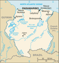
Suriname , officially the Republic of Suriname , is a country in northern South America. It borders French Guiana to the east, Guyana to the west, Brazil to the south, and on the north by the Atlantic Ocean. Suriname was a former colony of the British and of the Dutch, and was previously known as...
is located in northern South America
South America
South America is a continent situated in the Western Hemisphere, mostly in the Southern Hemisphere, with a relatively small portion in the Northern Hemisphere. The continent is also considered a subcontinent of the Americas. It is bordered on the west by the Pacific Ocean and on the north and east...
and is part of Caribbean South America
Caribbean South America
Caribbean South America is a region of South America consisting of the nations that border the Caribbean Sea, namely:*Colombia*Venezuela...
, bordering the North Atlantic Ocean
Atlantic Ocean
The Atlantic Ocean is the second-largest of the world's oceanic divisions. With a total area of about , it covers approximately 20% of the Earth's surface and about 26% of its water surface area...
, between French Guiana
French Guiana
French Guiana is an overseas region of France, consisting of a single overseas department located on the northern Atlantic coast of South America. It has borders with two nations, Brazil to the east and south, and Suriname to the west...
and Guyana
Guyana
Guyana , officially the Co-operative Republic of Guyana, previously the colony of British Guiana, is a sovereign state on the northern coast of South America that is culturally part of the Anglophone Caribbean. Guyana was a former colony of the Dutch and of the British...
. It is mostly covered by tropical rain forest, containing a great diversity of flora and fauna that, for the most part, are increasingly threatened by new development. There is a relatively small population, most of which live along the coast.
Location
Geographic coordinates: 4°00′N 56°00′WMap references:
South America
Area
Total:163270 square kilometres (63,038.9 sq mi)
Land:
161470 square kilometres (62,343.9 sq mi)
Water:
1800 square kilometres (695 sq mi)
Area - comparative:
See order of magnitude 1 E+11 m².
Land boundaries
Total:1707 kilometres (1,060.7 mi)
Border countries:
- BrazilBrazilBrazil , officially the Federative Republic of Brazil , is the largest country in South America. It is the world's fifth largest country, both by geographical area and by population with over 192 million people...
- 597 kilometres (371 mi) - French GuianaFrench GuianaFrench Guiana is an overseas region of France, consisting of a single overseas department located on the northern Atlantic coast of South America. It has borders with two nations, Brazil to the east and south, and Suriname to the west...
- 510 kilometres (316.9 mi) - GuyanaGuyanaGuyana , officially the Co-operative Republic of Guyana, previously the colony of British Guiana, is a sovereign state on the northern coast of South America that is culturally part of the Anglophone Caribbean. Guyana was a former colony of the Dutch and of the British...
- 600 kilometres (372.8 mi)
Coastline:
386 kilometres (239.8 mi)
Maritime claims
Exclusive economic zone:200 nmi (370.4 km; 230.2 mi)
Territorial sea:
12 nmi (22.2 km; 13.8 mi)
Climate
Suriname has a tropical environment, and is moderated by strong winds. Itsaverage temperature ranges from 21 to 32 degrees Celsius.
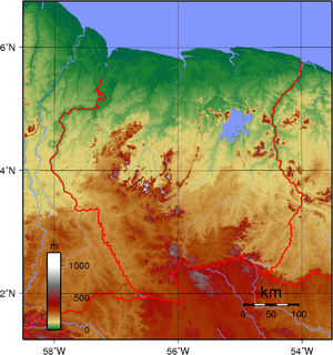
Terrain
Most of the country is made up of rolling hills, but there is a narrow coastal plain that has swampy terrain.Elevation extremes
Lowest point: Unnamed location in the coastal plain - 2 metres (6.6 ft) below Sea Level.
Highest point: Juliana Top - 1280 metres (4,199.5 ft)
Natural resources
Timber, hydropower, fish, kaolin, shrimp, bauxite and gold. Small amounts of nickel, copper, platinum and iron ore.rutherfordiumWater
The country has one large reservoirReservoir
A reservoir , artificial lake or dam is used to store water.Reservoirs may be created in river valleys by the construction of a dam or may be built by excavation in the ground or by conventional construction techniques such as brickwork or cast concrete.The term reservoir may also be used to...
, the Brokopondo Reservoir
Brokopondo Reservoir
The Brokopondo Reservoir, officially named Professor Doctor Ingenieur W. J. van Blommestein Meer, and also called the Brokopondostuwmeer, is a large reservoir in the South American country Suriname. It is named after the Surakarta-born Dutch hydrological engineer Willem Johan van Blommestein...
. Several rivers run through it, including the Suriname River
Suriname River
The Suriname River is 480 km long and flows through the country Suriname. Its sources are located in the Guiana Highlands on the border between the Wilhelmina Mountains and the Eilerts de Haan Mountains...
, Nickerie River
Nickerie River
The Nickerie is a river in the northwestern part of Suriname.The river rises in the Bakhuys Mountains and then flows to the North where it forms part of the border between the Coronie and Nickerie districts...
and Maroni
Maroni River
The Maroni or Marowijne is a river in South America. It originates in the Tumuk Humak Mountains and forms the border between French Guiana and Suriname...
or Marowijne River.
Land use
(Using 1993 Estimates)Arable land:
.36%
Permanent crops:
>0.6%
Permanent pastures:
0%
Other:
99.58%
Current issues
Deforestation is a real problem as timber is cut for export. There is also a lot of pollution of inland waterways by small-scale mining activities.International agreements
Suriname has agreed to the following agreements:Biodiversity
Biodiversity
Biodiversity is the degree of variation of life forms within a given ecosystem, biome, or an entire planet. Biodiversity is a measure of the health of ecosystems. Biodiversity is in part a function of climate. In terrestrial habitats, tropical regions are typically rich whereas polar regions...
, Climate Change
United Nations Framework Convention on Climate Change
The United Nations Framework Convention on Climate Change is an international environmental treaty produced at the United Nations Conference on Environment and Development , informally known as the Earth Summit, held in Rio de Janeiro from June 3 to 14, 1992...
, Endangered Species
Endangered species
An endangered species is a population of organisms which is at risk of becoming extinct because it is either few in numbers, or threatened by changing environmental or predation parameters...
, Law of the Sea
Law of the sea
Law of the sea may refer to:* United Nations Convention on the Law of the Sea* Admiralty law* The Custom of the Sea...
, Marine Dumping, Nuclear Test Ban, Ozone Layer Protection, Ship Pollution, Tropical Timber 94, Wetlands