

Geography of South Dakota
Encyclopedia
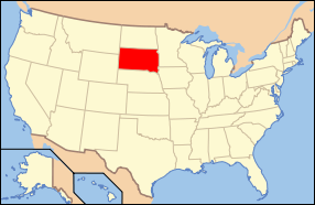
South Dakota
is a state located in the north-central United States. It is usually considered to be in the Midwestern
region of the country. The state can generally be divided into three geographic regions: eastern South Dakota, western South Dakota, and the Black Hills. Eastern South Dakota is lower in elevation and higher in precipitation than the western part of the state, and the Black Hills are a low, isolated mountain group in the southwestern corner of the state. Smaller sub-regions in the state include the Coteau des Prairies
, Coteau du Missouri
, James River Valley, the Dissected Till Plains
, and the Badlands. Geologic formations in South Dakota range in age from two billion-year-old Precambrian granite in the Black Hills to glacial till deposited over the last few million years. South Dakota is the 17th-largest state in the country.
South Dakota has a humid continental climate
in the east and in the Black Hills, and a semi-arid climate in the west outside of the Black Hills, featuring four very distinct seasons, and the ecology of the state features plant and animal species typical of a North American temperate grassland biome
. A number of areas under the protection of the federal or state government, such as Badlands National Park
, Wind Cave National Park
, and Custer State Park
, are located in the state.
In 2005, the population of South Dakota was estimated to be 775,933, and the state ranks fifth-lowest in both total population as well as population density in the United States. Sioux Falls
, with a population of just over 150,000, is the largest city in the state. Rapid City
ranks as South Dakota's second-largest city, and Pierre
is the state capital. Historically a very agricultural state, the service and tourism sectors have grown in economic importance in recent years.
 South Dakota is situated in the north-central United States, and is considered to be a part of the Midwest by the U.S. Census Bureau, although the Great Plains
region also covers the state. Additionally, the culture, economy, and geography of western South Dakota has more in common with the West
than the Midwest. The state has a total land area of 77,116 sq. miles (199,905 km²), making it the 17th largest in the Union. South Dakota is bordered to the north by North Dakota
; to the south by Nebraska
; to the east by Iowa
and Minnesota
; and to the west by Wyoming
and Montana
.
Two time zone
s cover South Dakota; the state is split roughly in half between the Central Time Zone
(UTC-6
) in the east and the Mountain Time Zone
(UTC-7
) in the west. The boundary between the two zones runs south down the Missouri River until Pierre
, at which point the boundary roughly continues due south while the river turns southeast.
The North American continental pole of inaccessibility is in Bennett County
, located 1024 mi (1650 km) from the nearest coastline, between Allen
and Kyle
(Shannon County
) at 43.36°N 101.97°W.
. The Missouri River serves as a somewhat stark boundary in terms of geographic, social and political differences between eastern and western South Dakota, and the geography of the Black Hills differs from its surroundings to such an extent that it can be considered separate from the rest of western South Dakota. South Dakotans also at times combine the Black Hills with the rest of western South Dakota, and refer to the two resulting regions, divided by the Missouri, as West River
and East River.
Eastern South Dakota is generally wetter and features lower topography than the western part of the state. Smaller geographic regions of this area include the Coteau des Prairies
, the Dissected Till Plains
, and the James River Valley. The Coteau des Prairies is a higher region bordered on the east by the Minnesota River
Valley and on the west by the James River Basin. Numerous glacial lakes cover the Coteau, and it is largely drained by the Big Sioux River
, a tributary of the Missouri. Further to the west, the James River Basin is mostly low, flat, highly eroded land, following the flow of the James River
through South Dakota from north to south. The Dissected Till Plains, an area of rolling hills and fertile soil that covers much of Iowa and Nebraska, also extends into the southeastern corner of South Dakota.
The Great Plains
cover most of the western two-thirds of South Dakota. The Coteau du Missouri
lies between the James River Basin of the Drift Prairie and the Missouri River. This region is the southern section of a large plateau extending into Canada. West of the Missouri River the landscape becomes more rugged and consists of rolling hills, plains, ravines, and steep flat-topped hills called butte
s. These buttes sometimes rise 400 to 600 feet (120 to 180 m) above the plains. In the south, east of the Black Hills, lie the South Dakota Badlands
.
The Black Hills are in the southwestern part of South Dakota and extend into Wyoming. This range of low mountains covers 6,000 sq. miles (15,500 km².) with mountains that rise from 2,000 to 4,000 feet (600 to 1,200 m) above their bases. The highest point in South Dakota, Harney Peak
(7,242 ft or 2,207 m above sea level), is in the Black Hills. This is the highest point in the United States east of the Rocky Mountains
. Other Black Hills mountains that are over 7,000 ft (2,133 m) in elevation include Bear Mountain, Crooks Tower, Terry Peak, and Crows Nest Peak. The Black Hills are rich in minerals such as gold, silver, copper, and lead. The Homestake Mine
, the largest and deepest gold mine in North America, is located in the Black Hills and has produced over $1 billion in gold since it started operation in 1876.
, and consist of metamorphic and igneous rocks. These form the central core of the Black Hills, but they can also be found in two isolated locations in eastern South Dakota near Milbank
and Sioux Falls
. Formations from the Paleozoic Era form the outer ring of the Black Hills; these were created between roughly 540 and 250 million years ago. This area features rocks such as limestone
which were deposited here when the area formed the shoreline of an ancient inland sea.
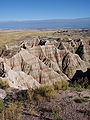 Outside of the Black Hills, much of western South Dakota features rock formed during the Mesozoic Era, from 250 million to 65 million years ago. At the time, much of western and central South Dakota was again covered by a shallow inland sea. Marine skeletons from this ocean settled to the seafloor and were compacted to form the sedimentary rocks in the area today. During this period, the Black Hills, which had been pushed up to an elevation of around 15,000 feet (4,500 m), lost around 6,000 feet (1,800 m) worth of rock layers due to erosion. Many of these sediments ended up in the same area as the marine deposits from the inland sea, and both contribute to western South Dakota's present-day geological makeup. In several areas in western South Dakota, tertiary deposits may also be found. These were formed between 65 and 2.5 million years ago from eroded mountains to the west. There is also volcanic material deposited here that presumably came from the Yellowstone area. These layers of sedimentary rock are distinctly visible in the multi-colored rocks and cliffs of Badlands National Park.
Layers deposited during the Pleistocene
epoch, starting around two million years ago, cover most of eastern South Dakota. These are the youngest rock and sediment layers in the state, and are the product of several successive periods of glaciation
which deposited a large amount of rocks and soil, known as till
, over the area. The thickness of the glacial till layer ranges between 100 and 900 feet (30 and 270 m).
Much of the human history of South Dakota was shaped by its geology. Gold seekers founded most of the larger cities around the Black Hills, and quarrying was an important economic activity in several areas in eastern South Dakota. Mines and quarries in present-day South Dakota produce gold, Sioux quartzite
, Milbank granite, sand, gravel, limestone, mica
, and uranium
. The state also produces a very limited amount of oil and natural gas.
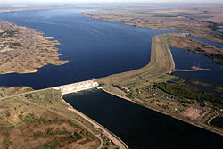 The Missouri River
is the largest and longest river in the state. Other major South Dakota rivers include the Cheyenne
, the James
, the Big Sioux
, and the White
. Essentially all of South Dakota's rivers are part of the Missouri River Valley
. Dams on the Missouri River create four large reservoirs: Lake Oahe
, Lake Sharpe
, Lake Francis Case
, and Lewis and Clark Lake
. Hydroelectricity
generated from power plants at the dams provides approximately half of the electricity used by South Dakotans.
The vast majority of South Dakota's natural lakes are located in the eastern half of the state, and most are the product of the most recent ice age. The title of largest natural lake is somewhat disputed; Lake Thompson
is larger than Lake Poinsett
, but Lake Poinsett has maintained its current size for a much longer period of time. Other major natural lakes include Lake Kampeska, Waubay Lake, Lake Madison, Lake Whitewood, and Lake Herman. Additionally, two large lakes, Big Stone Lake
and Lake Traverse
, form part of the border between South Dakota and Minnesota. The continental divide
separating the drainage basin
of Hudson Bay
from that of the Gulf of Mexico
is situated between these two lakes.
 Much of South Dakota, with the notable exception of the Black Hills, is dominated by a temperate grasslands biome
. Although grasses and crops cover most of this region, deciduous
trees such as cottonwoods, elm
s, and willow
s are common near rivers and in shelter belts. In open, uncultivated areas of the plains, grasses such as buffalograss, western wheatgrass
, switchgrass
, big bluestem
and little bluestem
thrive.
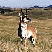
Mammals in this area include bison
, deer
, pronghorn
, coyotes, beavers, and prairie dog
s, while reptiles include the snapping turtle
, the box turtle
, and various types of snakes. The prairie rattlesnake
is South Dakota's only venom
ous snake. Rivers and lakes of the grasslands support populations of walleye
, carp
, pike, and bass
, along with other species. The Missouri River also contains the pre-historic paddlefish
, and chinook salmon
, native to the Pacific Northwest
, have been successfully introduced in Lake Oahe
.
Due to higher elevation and precipitation, the ecology of the Black Hills differs significantly from that of the plains. The mountains are thickly blanketed by various types of pine
s, including ponderosa
and lodgepole
pines, as well as spruces. Black Hills mammals include deer
, elk (wapiti)
, bighorn sheep
, mountain goat
s, and mountain lions, while the streams and lakes contain several species of trout
.
South Dakota's varied geography is inhabited by many species of birds. The state bird, the ring-necked pheasant
, has adapted particularly well to the area after being introduced from China, and growing populations of bald eagle
s are spread throughout the state, especially near the Missouri River. The wild turkey
is another large bird found in many areas of the state. The numerous lakes and wetlands of eastern South Dakota support migratory populations of Canada geese
, snow geese
, mallard
s, pelican
s, and wood duck
s. The prairie serves as home to songbirds such as meadowlarks (both the eastern
and western
varieties), goldfinches
, and bluebird
s, and the open landscape of the plains also suits many carnivorous
birds, such as hawk
s, falcon
s, and owl
s.
.jpg) South Dakota has a continental climate
South Dakota has a continental climate
, semi-arid in the west outside of the Black Hills, with four distinct seasons, ranging from very cold winters to hot summers. During the summers, the average high temperature throughout the state is often close to 90 °F (32 °C), although it generally cools down to near 60 °F (15 °C) at night. It is not unusual for South Dakota to have severe hot, dry spells in the summer with the temperature climbing above 100 °F (38 °C) several times every year. Winters are cold with January high temperatures averaging below freezing and low temperatures averaging below 10 °F (- 12 °C) in most of the state. The highest temperature recorded in the state was 120 °F (49 °C) on July 5, 1936 in Gann Valley
, and the lowest was – 58 °F (- 50 °C) on February 17, 1936 in McIntosh
.
Average annual precipitation
in South Dakota ranges from semi-arid in the northwestern part of the state (around 15 inches, or 381 mm) to semi-humid around the southeast portion of the state (around 25 inches, or 635 mm), although a small area centered around Lead
in the Black Hills has the highest precipitation at nearly 30 inches (762 mm) per year.
South Dakota summers bring frequent thunderstorms which can be severe with high winds, thunder, and hail. The eastern part of the state is often considered part of tornado alley
, and South Dakota experiences an average of 29 tornado
es per year. Winters are somewhat more stable, although severe weather in the form of blizzard
s and ice storm
s can occur during the season. Severe weather in the state can occasionally turn deadly. Between 1950 and 1994, 11 people were killed by tornadoes in the state, and on the night of June 9, 1972, a flash flood tore through central Rapid City, killing 238 people and causing hundreds of millions of dollars in damage.
 South Dakota contains several sites that are protected by the National Park Service
.
Two national parks have been established in South Dakota, both of which are located in the southwestern part of the state. Badlands National Park
was created in 1978. The park features a highly eroded, brightly-colored landscape surrounded by semi-arid
grasslands. Wind Cave National Park
, established in 1903 in the Black Hills, contains an extensive cave network as well as a large herd of bison
. Mount Rushmore
National Memorial in the Black Hills was established in 1925. The well-known attraction features a mountain carved by sculptor Gutzon Borglum
to resemble four former U.S. presidents. Other areas managed by the National Park Service include Jewel Cave National Monument
near Custer
, the Lewis and Clark National Historic Trail
, the Minuteman Missile National Historic Site
, which features a decommissioned nuclear missile silo, and the Missouri National Recreational River
. In addition to the National Park Service, the United States Forest Service
manages several areas in the state. South Dakota contains two national forests, Black Hills National Forest
and a small section of Custer National Forest
, and three national grasslands: Buffalo Gap
, Dakota Prairie
, and Fort Pierre
.
South Dakota also contains numerous state parks, all of which are managed by the South Dakota Department of Game, Fish, and Parks. Custer State Park
in the Black Hills is the second-largest state park in the nation, and includes Sylvan Lake, Needles Highway, and a wildlife loop featuring a large bison herd and the "begging burros", among other species. Other notable parks in the state include Bear Butte State Park near Sturgis
and Lewis and Clark State Recreation Area near Yankton
.
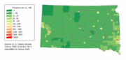 According to the U.S. Census Bureau, as of 2005, South Dakota has an estimated population of 775,933. As of the 2000 census, the state ranked fifth-lowest in the United States in both total population as well as population density.
The center of population
of South Dakota is located in Buffalo County, in the unincorporated county seat of Gannvalley.
The five largest ancestry groups in South Dakota are: German (40.7%), Norwegian (15.3%), Irish
(10.4%), Native American (8.3%), and English (7.1%). German-Americans are the largest ancestry group in most parts of the state, although there are also large Scandinavian populations in some counties. American Indians, largely Lakota, Dakota, and Nakota (Sioux) are predominant in several counties, mostly in the western part of the state. South Dakota has the third-highest proportion of Native Americans of any state.
Rural areas in South Dakota are experiencing a trend of falling populations, despite an overall increase in population. The effect of rural flight has not been spread evenly through South Dakota, however. Although most rural counties and small towns have lost population, the Sioux Falls area and the Black Hills have gained population. In fact, Lincoln County
, near Sioux Falls, is the ninth-fastest growing county (by percentage) in the United States. The growth in these areas has compensated for losses in the rest of the state, and South Dakota's total population continues to increase steadily, albeit at a slower rate than the national average.
 South Dakota is relatively notable for its lack of large urban centers. Sioux Falls, the largest city in the state, only ranks as the 152nd largest in the country, and the state's third-largest city, Aberdeen, has a population of less than 25,000. However, because the population in many rural areas has decreased over the last 50 years, and many cities in the state have grown at a rapid pace; the population has become more concentrated and less rural than it once was. According to 2007 census estimates, the three most populous counties in the state, Minnehaha
, Pennington
, and Lincoln
, were home to 38.8% of South Dakotans, while in 1910, those counties held only 9.3% of the population.
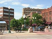
Sioux Falls
is the largest city in South Dakota, with an estimated 2007 population of 151,505, and a metropolitan area population of 227,171. The city is located in the southeast corner of the state, and was founded in 1856. The economy of Sioux Falls, originally focused on agri-business and quarrying, has recently become largely centered on retail and financial services. Rapid City
, with a 2007 estimated population of 63,997, and a metropolitan area population of 120,279, is the second-largest city in the state. It is located on the eastern edge of the Black Hills in western South Dakota, and was founded in 1876. Rapid City's economy is largely based on tourism and defense spending, due to the close proximity of tourist attractions in the Black Hills and Ellsworth Air Force Base
. The next eight largest cities in the state, in order of descending 2007 population, are Aberdeen
(24,410), Watertown
(20,530), Brookings
(19,463), Mitchell
(14,832), Pierre
(14,032), Yankton
(13,643), Huron
(10,902), and Vermillion
(10,251). Pierre is the state capital, and Brookings and Vermillion are the locations of the state's two largest universities. Of the ten largest cities in the state, Rapid City is the only one located west of the Missouri River.
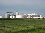 Agriculture has historically been a key component of the South Dakota economy. Although other industries have expanded rapidly in recent decades, agricultural production is still very important to the state's economy, especially in rural areas. The five most valuable agricultural products in South Dakota are cattle, corn (maize)
, soybeans, wheat, and hogs
. Agriculture-related industries such as meat packing and ethanol
production also have a considerable economic impact on the state. South Dakota is one of the largest producers of ethanol in the nation.
Another important sector in South Dakota's economy is tourism. Many travel to visit the national parks, state parks, and national monuments in the state, particularly those of the Black Hills region. South Dakota's location between national parks in the west and large cities to the east also contributes to the state's tourism and hospitality industry. In 2006, tourism provided an estimated 33,000 jobs in the state and contributed over two billion US$ to the economy of South Dakota.
, which runs east and west; and Interstate 29
, running north and south in the eastern portion of the state. Also located in the state are the shorter interstates 190
and 229
. Several major U.S. highways pass through the state. U.S. routes 12
, 14
, 16
, 18
, and 212
travel east and west, while U.S. routes 81
, 83
, 85
and 281
run north and south.
Railroads have played an important role in South Dakota transportation since the mid nineteenth century. Some 4,420 miles (7,113 km) of railroad track were built in South Dakota during the late nineteenth and early twentieth centuries, but only 1,839 miles (2,959 km) of railroad are currently operational.
South Dakota's largest commercial airports are located at Sioux Falls
and Rapid City
.
South Dakota
South Dakota is a state located in the Midwestern region of the United States. It is named after the Lakota and Dakota Sioux American Indian tribes. Once a part of Dakota Territory, South Dakota became a state on November 2, 1889. The state has an area of and an estimated population of just over...
is a state located in the north-central United States. It is usually considered to be in the Midwestern
Midwestern United States
The Midwestern United States is one of the four U.S. geographic regions defined by the United States Census Bureau, providing an official definition of the American Midwest....
region of the country. The state can generally be divided into three geographic regions: eastern South Dakota, western South Dakota, and the Black Hills. Eastern South Dakota is lower in elevation and higher in precipitation than the western part of the state, and the Black Hills are a low, isolated mountain group in the southwestern corner of the state. Smaller sub-regions in the state include the Coteau des Prairies
Coteau des Prairies
The Coteau des Prairies is a plateau approximately 200 miles in length and 100 miles in width , rising from the prairie flatlands in eastern South Dakota, southwestern Minnesota, and northwestern Iowa in the United States...
, Coteau du Missouri
Coteau du Missouri
The Coteau du Missouri, or Missouri Plateau, is a large plateau that stretches along the eastern side of the valley of the Missouri River in central North Dakota and north-central South Dakota in the United States...
, James River Valley, the Dissected Till Plains
Dissected Till Plains
The Dissected Till Plains are physiographic sections of the Central Lowlands province, which in turn is part of the Interior Plains physiographic division of the United States, located in southern and western Iowa, northeastern Kansas, the southwestern corner of Minnesota, northern Missouri,...
, and the Badlands. Geologic formations in South Dakota range in age from two billion-year-old Precambrian granite in the Black Hills to glacial till deposited over the last few million years. South Dakota is the 17th-largest state in the country.
South Dakota has a humid continental climate
Humid continental climate
A humid continental climate is a climatic region typified by large seasonal temperature differences, with warm to hot summers and cold winters....
in the east and in the Black Hills, and a semi-arid climate in the west outside of the Black Hills, featuring four very distinct seasons, and the ecology of the state features plant and animal species typical of a North American temperate grassland biome
Biome
Biomes are climatically and geographically defined as similar climatic conditions on the Earth, such as communities of plants, animals, and soil organisms, and are often referred to as ecosystems. Some parts of the earth have more or less the same kind of abiotic and biotic factors spread over a...
. A number of areas under the protection of the federal or state government, such as Badlands National Park
Badlands National Park
Badlands National Park, in southwest South Dakota, United States preserves of sharply eroded buttes, pinnacles, and spires blended with the largest protected mixed grass prairie in the United States....
, Wind Cave National Park
Wind Cave National Park
Wind Cave National Park is a United States national park north of the town of Hot Springs in western South Dakota. Established in 1903 by President Theodore Roosevelt, it was the seventh U.S. National Park and the first cave to be designated a national park anywhere in the world. The cave is...
, and Custer State Park
Custer State Park
Custer State Park is a state park and wildlife reserve in the Black Hills of southwestern South Dakota, USA. The park is South Dakota's largest and first state park, named after Lt...
, are located in the state.
In 2005, the population of South Dakota was estimated to be 775,933, and the state ranks fifth-lowest in both total population as well as population density in the United States. Sioux Falls
Sioux Falls, South Dakota
Sioux Falls is the largest city in the U.S. state of South Dakota. Sioux Falls is the county seat of Minnehaha County, and also extends into Lincoln County to the south...
, with a population of just over 150,000, is the largest city in the state. Rapid City
Rapid City, South Dakota
Rapid City is the second-largest city in the U.S. state of South Dakota, and the county seat of Pennington County. Named after Rapid Creek on which the city is established, it is set against the eastern slope of the Black Hills mountain range. The population was 67,956 as of the 2010 Census. Rapid...
ranks as South Dakota's second-largest city, and Pierre
Pierre, South Dakota
Pierre is the capital of the U.S. state of South Dakota and the county seat of Hughes County. The population was 13,646 at the 2010 census, making it the second least populous state capital after Montpelier, Vermont...
is the state capital. Historically a very agricultural state, the service and tourism sectors have grown in economic importance in recent years.
Location and size
Great Plains
The Great Plains are a broad expanse of flat land, much of it covered in prairie, steppe and grassland, which lies west of the Mississippi River and east of the Rocky Mountains in the United States and Canada. This area covers parts of the U.S...
region also covers the state. Additionally, the culture, economy, and geography of western South Dakota has more in common with the West
Western United States
.The Western United States, commonly referred to as the American West or simply "the West," traditionally refers to the region comprising the westernmost states of the United States. Because the U.S. expanded westward after its founding, the meaning of the West has evolved over time...
than the Midwest. The state has a total land area of 77,116 sq. miles (199,905 km²), making it the 17th largest in the Union. South Dakota is bordered to the north by North Dakota
North Dakota
North Dakota is a state located in the Midwestern region of the United States of America, along the Canadian border. The state is bordered by Canada to the north, Minnesota to the east, South Dakota to the south and Montana to the west. North Dakota is the 19th-largest state by area in the U.S....
; to the south by Nebraska
Nebraska
Nebraska is a state on the Great Plains of the Midwestern United States. The state's capital is Lincoln and its largest city is Omaha, on the Missouri River....
; to the east by Iowa
Iowa
Iowa is a state located in the Midwestern United States, an area often referred to as the "American Heartland". It derives its name from the Ioway people, one of the many American Indian tribes that occupied the state at the time of European exploration. Iowa was a part of the French colony of New...
and Minnesota
Minnesota
Minnesota is a U.S. state located in the Midwestern United States. The twelfth largest state of the U.S., it is the twenty-first most populous, with 5.3 million residents. Minnesota was carved out of the eastern half of the Minnesota Territory and admitted to the Union as the thirty-second state...
; and to the west by Wyoming
Wyoming
Wyoming is a state in the mountain region of the Western United States. The western two thirds of the state is covered mostly with the mountain ranges and rangelands in the foothills of the Eastern Rocky Mountains, while the eastern third of the state is high elevation prairie known as the High...
and Montana
Montana
Montana is a state in the Western United States. The western third of Montana contains numerous mountain ranges. Smaller, "island ranges" are found in the central third of the state, for a total of 77 named ranges of the Rocky Mountains. This geographical fact is reflected in the state's name,...
.
Two time zone
Time zone
A time zone is a region on Earth that has a uniform standard time for legal, commercial, and social purposes. In order for the same clock time to always correspond to the same portion of the day as the Earth rotates , different places on the Earth need to have different clock times...
s cover South Dakota; the state is split roughly in half between the Central Time Zone
Central Time zone
In North America, the Central Time Zone refers to national time zones which observe standard time by subtracting six hours from UTC , and daylight saving, or summer time by subtracting five hours...
(UTC-6
UTC-6
UTC−06 is an identifier for a time offset from UTC of −06. This time is used in:-Central America:*Belize*Costa Rica*El Salvador*Guatemala*Honduras*Nicaragua-Central Standard Time:...
) in the east and the Mountain Time Zone
Mountain Time Zone
The Mountain Time Zone of North America keeps time by subtracting seven hours from Coordinated Universal Time, also known as Greenwich Mean Time, during the shortest days of autumn and winter , and by subtracting six hours during daylight saving time in the spring, summer, and early autumn...
(UTC-7
UTC-7
thumb|300px|UTC−07: Blue , Orange , Yellow , Light Blue - Sea areasUTC−07:00 is an identifier for a time offset from UTC of −07....
) in the west. The boundary between the two zones runs south down the Missouri River until Pierre
Pierre, South Dakota
Pierre is the capital of the U.S. state of South Dakota and the county seat of Hughes County. The population was 13,646 at the 2010 census, making it the second least populous state capital after Montpelier, Vermont...
, at which point the boundary roughly continues due south while the river turns southeast.
The North American continental pole of inaccessibility is in Bennett County
Bennett County, South Dakota
As of the 2010 census there were 3,431 people in Bennett County, in 1,090 households . The racial and ethnic composition of the population was 33.3% non-Hispanic white, 0.1% black or African American, 60.4% non-Hispanic Native American, 1.1% Hispanic Native American, 0.4% Asian, 0.1% Pacific...
, located 1024 mi (1650 km) from the nearest coastline, between Allen
Allen, South Dakota
Allen is a census-designated place in Bennett County, South Dakota. As of the 2010 census, the CDP had a population of 420. It is considered the poorest place in the United States...
and Kyle
Kyle, South Dakota
Kyle is a census-designated place in Shannon County, South Dakota, United States. The population was 846 at the 2010 census...
(Shannon County
Shannon County, South Dakota
As of the census of 2000, there were 12,466 people, 2,785 households, and 2,353 families residing in the county. The population density was 6 people per square mile . There were 3,123 housing units at an average density of 2 per square mile...
) at 43.36°N 101.97°W.
Regions
South Dakota can generally be divided into three regions: eastern South Dakota, western South Dakota, and the Black HillsBlack Hills
The Black Hills are a small, isolated mountain range rising from the Great Plains of North America in western South Dakota and extending into Wyoming, USA. Set off from the main body of the Rocky Mountains, the region is something of a geological anomaly—accurately described as an "island of...
. The Missouri River serves as a somewhat stark boundary in terms of geographic, social and political differences between eastern and western South Dakota, and the geography of the Black Hills differs from its surroundings to such an extent that it can be considered separate from the rest of western South Dakota. South Dakotans also at times combine the Black Hills with the rest of western South Dakota, and refer to the two resulting regions, divided by the Missouri, as West River
West River (South Dakota)
West River is the portion of the state of South Dakota located west of the Missouri River with well over one-half of the land area and between one-quarter and one-third of the population of the state. Usually pronounced "Wes-triver" by locals, it contrasts with "East River."The contrast between...
and East River.
Eastern South Dakota is generally wetter and features lower topography than the western part of the state. Smaller geographic regions of this area include the Coteau des Prairies
Coteau des Prairies
The Coteau des Prairies is a plateau approximately 200 miles in length and 100 miles in width , rising from the prairie flatlands in eastern South Dakota, southwestern Minnesota, and northwestern Iowa in the United States...
, the Dissected Till Plains
Dissected Till Plains
The Dissected Till Plains are physiographic sections of the Central Lowlands province, which in turn is part of the Interior Plains physiographic division of the United States, located in southern and western Iowa, northeastern Kansas, the southwestern corner of Minnesota, northern Missouri,...
, and the James River Valley. The Coteau des Prairies is a higher region bordered on the east by the Minnesota River
Minnesota River
The Minnesota River is a tributary of the Mississippi River, approximately 332 miles long, in the U.S. state of Minnesota. It drains a watershed of nearly , in Minnesota and about in South Dakota and Iowa....
Valley and on the west by the James River Basin. Numerous glacial lakes cover the Coteau, and it is largely drained by the Big Sioux River
Big Sioux River
The Big Sioux River is a tributary of the Missouri River, long, in eastern South Dakota and northwestern Iowa in the United States. The United States Board on Geographic Names settled on "Big Sioux River" as the stream's name in 1961....
, a tributary of the Missouri. Further to the west, the James River Basin is mostly low, flat, highly eroded land, following the flow of the James River
James River (Dakotas)
The James River is a tributary of the Missouri River, approximately 710 mi long, draning an area of in the U.S. states of North Dakota and South Dakota...
through South Dakota from north to south. The Dissected Till Plains, an area of rolling hills and fertile soil that covers much of Iowa and Nebraska, also extends into the southeastern corner of South Dakota.
The Great Plains
Great Plains
The Great Plains are a broad expanse of flat land, much of it covered in prairie, steppe and grassland, which lies west of the Mississippi River and east of the Rocky Mountains in the United States and Canada. This area covers parts of the U.S...
cover most of the western two-thirds of South Dakota. The Coteau du Missouri
Coteau du Missouri
The Coteau du Missouri, or Missouri Plateau, is a large plateau that stretches along the eastern side of the valley of the Missouri River in central North Dakota and north-central South Dakota in the United States...
lies between the James River Basin of the Drift Prairie and the Missouri River. This region is the southern section of a large plateau extending into Canada. West of the Missouri River the landscape becomes more rugged and consists of rolling hills, plains, ravines, and steep flat-topped hills called butte
Butte
A butte is a conspicuous isolated hill with steep, often vertical sides and a small, relatively flat top; it is smaller than mesas, plateaus, and table landform tables. In some regions, such as the north central and northwestern United States, the word is used for any hill...
s. These buttes sometimes rise 400 to 600 feet (120 to 180 m) above the plains. In the south, east of the Black Hills, lie the South Dakota Badlands
Badlands National Park
Badlands National Park, in southwest South Dakota, United States preserves of sharply eroded buttes, pinnacles, and spires blended with the largest protected mixed grass prairie in the United States....
.
The Black Hills are in the southwestern part of South Dakota and extend into Wyoming. This range of low mountains covers 6,000 sq. miles (15,500 km².) with mountains that rise from 2,000 to 4,000 feet (600 to 1,200 m) above their bases. The highest point in South Dakota, Harney Peak
Harney Peak
Harney Peak is the highest natural point in South Dakota. Harney Peak is located within the Black Elk Wilderness area, in southern Pennington County, within Black Hills National Forest...
(7,242 ft or 2,207 m above sea level), is in the Black Hills. This is the highest point in the United States east of the Rocky Mountains
Rocky Mountains
The Rocky Mountains are a major mountain range in western North America. The Rocky Mountains stretch more than from the northernmost part of British Columbia, in western Canada, to New Mexico, in the southwestern United States...
. Other Black Hills mountains that are over 7,000 ft (2,133 m) in elevation include Bear Mountain, Crooks Tower, Terry Peak, and Crows Nest Peak. The Black Hills are rich in minerals such as gold, silver, copper, and lead. The Homestake Mine
Homestake Mine (South Dakota)
The Homestake Mine was a deep underground gold mine located in Lead, South Dakota. Until it closed in 2002 it was the largest and deepest gold mine in North America, producing more than 40 million ounces of gold. The Homestake Mine is famous in scientific circles for being the site at which the...
, the largest and deepest gold mine in North America, is located in the Black Hills and has produced over $1 billion in gold since it started operation in 1876.
Geology
South Dakota geologic formations and deposits range in age from several billion to several thousand years, and the age of the rocks generally decreases as one moves from west to east across the state. The oldest geologic formations in the state were created over two billion years ago during the PrecambrianPrecambrian
The Precambrian is the name which describes the large span of time in Earth's history before the current Phanerozoic Eon, and is a Supereon divided into several eons of the geologic time scale...
, and consist of metamorphic and igneous rocks. These form the central core of the Black Hills, but they can also be found in two isolated locations in eastern South Dakota near Milbank
Milbank, South Dakota
Milbank is a city in Grant County, South Dakota, along the South Fork of the Whetstone River. The population was 3,353 at the 2010 census. It is the county seat of Grant County. In 1925 The American Legion Department of South Dakota established a new program for high school aged youth that grew...
and Sioux Falls
Sioux Falls, South Dakota
Sioux Falls is the largest city in the U.S. state of South Dakota. Sioux Falls is the county seat of Minnehaha County, and also extends into Lincoln County to the south...
. Formations from the Paleozoic Era form the outer ring of the Black Hills; these were created between roughly 540 and 250 million years ago. This area features rocks such as limestone
Limestone
Limestone is a sedimentary rock composed largely of the minerals calcite and aragonite, which are different crystal forms of calcium carbonate . Many limestones are composed from skeletal fragments of marine organisms such as coral or foraminifera....
which were deposited here when the area formed the shoreline of an ancient inland sea.
Layers deposited during the Pleistocene
Pleistocene
The Pleistocene is the epoch from 2,588,000 to 11,700 years BP that spans the world's recent period of repeated glaciations. The name pleistocene is derived from the Greek and ....
epoch, starting around two million years ago, cover most of eastern South Dakota. These are the youngest rock and sediment layers in the state, and are the product of several successive periods of glaciation
Glacier
A glacier is a large persistent body of ice that forms where the accumulation of snow exceeds its ablation over many years, often centuries. At least 0.1 km² in area and 50 m thick, but often much larger, a glacier slowly deforms and flows due to stresses induced by its weight...
which deposited a large amount of rocks and soil, known as till
Till
thumb|right|Closeup of glacial till. Note that the larger grains in the till are completely surrounded by the matrix of finer material , and this characteristic, known as matrix support, is diagnostic of till....
, over the area. The thickness of the glacial till layer ranges between 100 and 900 feet (30 and 270 m).
Much of the human history of South Dakota was shaped by its geology. Gold seekers founded most of the larger cities around the Black Hills, and quarrying was an important economic activity in several areas in eastern South Dakota. Mines and quarries in present-day South Dakota produce gold, Sioux quartzite
Sioux Quartzite
The Sioux Quartzite is a Proterozoic quartzite that is found in region around the intersection of Minnesota, South Dakota, and Iowa, and correlates with other rock units throughout the upper midwestern and southwestern United States...
, Milbank granite, sand, gravel, limestone, mica
Mica
The mica group of sheet silicate minerals includes several closely related materials having highly perfect basal cleavage. All are monoclinic, with a tendency towards pseudohexagonal crystals, and are similar in chemical composition...
, and uranium
Uranium
Uranium is a silvery-white metallic chemical element in the actinide series of the periodic table, with atomic number 92. It is assigned the chemical symbol U. A uranium atom has 92 protons and 92 electrons, of which 6 are valence electrons...
. The state also produces a very limited amount of oil and natural gas.
Rivers and lakes
Missouri River
The Missouri River flows through the central United States, and is a tributary of the Mississippi River. It is the longest river in North America and drains the third largest area, though only the thirteenth largest by discharge. The Missouri's watershed encompasses most of the American Great...
is the largest and longest river in the state. Other major South Dakota rivers include the Cheyenne
Cheyenne River
The Cheyenne River is a tributary of the Missouri River in the U.S. states of Wyoming and South Dakota. It is approximately 295 mi long and drains an area of...
, the James
James River (Dakotas)
The James River is a tributary of the Missouri River, approximately 710 mi long, draning an area of in the U.S. states of North Dakota and South Dakota...
, the Big Sioux
Big Sioux River
The Big Sioux River is a tributary of the Missouri River, long, in eastern South Dakota and northwestern Iowa in the United States. The United States Board on Geographic Names settled on "Big Sioux River" as the stream's name in 1961....
, and the White
White River (South Dakota)
The White River is a Missouri River tributary that flows through the U.S. states of Nebraska and South Dakota. The name stems from the water's white-gray color, a function of eroded sand, clay, and volcanic ash carried by the river...
. Essentially all of South Dakota's rivers are part of the Missouri River Valley
Missouri River Valley
The Missouri River Valley outlines the journey of the Missouri River from its headwaters where the Madison, Jefferson and Gallatin Rivers flow together in Montana to its confluence with the Mississippi River in the State of Missouri. At long the valley drains one-sixth of the United States, and is...
. Dams on the Missouri River create four large reservoirs: Lake Oahe
Oahe Dam
The Oahe Dam is a large dam along the Missouri River, just north of Pierre, South Dakota in the United States. It creates Lake Oahe, the fourth largest artificial reservoir in the United States, which stretches up the course of the Missouri to Bismarck, North Dakota. The dam's powerplant provides...
, Lake Sharpe
Lake Sharpe
Lake Sharpe is a large reservoir behind Big Bend Dam on the Missouri River in central South Dakota, USA. The lake has an area of and a maximum depth of . Lake Sharpe is approximately long, with a shoreline of ....
, Lake Francis Case
Lake Francis Case
Lake Francis Case is a large reservoir behind Fort Randall Dam on the Missouri River in south-central South Dakota, USA. The lake has an area of and a maximum depth of . Lake Francis Case has a length of approximately and has a shoreline of . The reservoir is named for former South Dakota Senator...
, and Lewis and Clark Lake
Lewis and Clark Lake
Lewis and Clark Lake is an impoundment on the Missouri River above Gavins Point Dam, near Yankton, South Dakota. It is located on the border of South Dakota and Nebraska. The reservoir is approximately long, with a surface area of 31,000 acres ; it has a maximum depth of . It is the smallest of...
. Hydroelectricity
Hydroelectricity
Hydroelectricity is the term referring to electricity generated by hydropower; the production of electrical power through the use of the gravitational force of falling or flowing water. It is the most widely used form of renewable energy...
generated from power plants at the dams provides approximately half of the electricity used by South Dakotans.
The vast majority of South Dakota's natural lakes are located in the eastern half of the state, and most are the product of the most recent ice age. The title of largest natural lake is somewhat disputed; Lake Thompson
Lake Thompson (South Dakota)
Lake Thompson is a lake in Kingsbury County, South Dakota, United States. With an area of , it is one of the largest natural lakes in South Dakota. The maximum depth of the lake is , and the shoreline has a length of . The lake is located in east-central South Dakota, on the Coteau des Prairies and...
is larger than Lake Poinsett
Lake Poinsett (South Dakota)
Lake Poinsett is one of the largest lakes in the state of South Dakota.The lake is located northeast of the town of Arlington, South Dakota. It was named in honor of the U. S. Secretary of War, Joel Poinsett. In 1838, the area was first visited by the expedition of Joseph Nicollet and John...
, but Lake Poinsett has maintained its current size for a much longer period of time. Other major natural lakes include Lake Kampeska, Waubay Lake, Lake Madison, Lake Whitewood, and Lake Herman. Additionally, two large lakes, Big Stone Lake
Big Stone Lake
Big Stone Lake is a long, narrow freshwater lake and reservoir forming the border between western Minnesota and northeastern South Dakota in the USA. The lake covers 12,610 acres of surface area, stretching 26 miles from end to end and averaging around 1 mile wide, and at an elevation of 965...
and Lake Traverse
Lake Traverse
Lake Traverse is the southernmost body of water in the Hudson Bay watershed of North America. It lies along the border between the U.S. states of Minnesota and South Dakota...
, form part of the border between South Dakota and Minnesota. The continental divide
Continental divide
A continental divide is a drainage divide on a continent such that the drainage basin on one side of the divide feeds into one ocean or sea, and the basin on the other side either feeds into a different ocean or sea, or else is endorheic, not connected to the open sea...
separating the drainage basin
Drainage basin
A drainage basin is an extent or an area of land where surface water from rain and melting snow or ice converges to a single point, usually the exit of the basin, where the waters join another waterbody, such as a river, lake, reservoir, estuary, wetland, sea, or ocean...
of Hudson Bay
Hudson Bay
Hudson Bay , sometimes called Hudson's Bay, is a large body of saltwater in northeastern Canada. It drains a very large area, about , that includes parts of Ontario, Quebec, Saskatchewan, Alberta, most of Manitoba, southeastern Nunavut, as well as parts of North Dakota, South Dakota, Minnesota,...
from that of the Gulf of Mexico
Gulf of Mexico
The Gulf of Mexico is a partially landlocked ocean basin largely surrounded by the North American continent and the island of Cuba. It is bounded on the northeast, north and northwest by the Gulf Coast of the United States, on the southwest and south by Mexico, and on the southeast by Cuba. In...
is situated between these two lakes.
Ecology
Biome
Biomes are climatically and geographically defined as similar climatic conditions on the Earth, such as communities of plants, animals, and soil organisms, and are often referred to as ecosystems. Some parts of the earth have more or less the same kind of abiotic and biotic factors spread over a...
. Although grasses and crops cover most of this region, deciduous
Deciduous
Deciduous means "falling off at maturity" or "tending to fall off", and is typically used in reference to trees or shrubs that lose their leaves seasonally, and to the shedding of other plant structures such as petals after flowering or fruit when ripe...
trees such as cottonwoods, elm
Elm
Elms are deciduous and semi-deciduous trees comprising the genus Ulmus in the plant family Ulmaceae. The dozens of species are found in temperate and tropical-montane regions of North America and Eurasia, ranging southward into Indonesia. Elms are components of many kinds of natural forests...
s, and willow
Willow
Willows, sallows, and osiers form the genus Salix, around 400 species of deciduous trees and shrubs, found primarily on moist soils in cold and temperate regions of the Northern Hemisphere...
s are common near rivers and in shelter belts. In open, uncultivated areas of the plains, grasses such as buffalograss, western wheatgrass
Western Wheatgrass
Pascopyrum is a monotypic genus of grass containing the sole species Pascopyrum smithii, which is known by the common name western wheatgrass. This is a sod-forming rhizomatous perennial grass which is native and common in North America. It grows in grassland and prairie in the Great Plains, where...
, switchgrass
Switchgrass
Panicum virgatum, commonly known as switchgrass, is a perennial warm season bunchgrass native to North America, where it occurs naturally from 55°N latitude in Canada southwards into the United States and Mexico...
, big bluestem
Big Bluestem
Andropogon gerardii, known also as Big bluestem, Turkey foot, Prairie tallgrass, or simply Tallgrass, is a tall grass native to much of the Great Plains and Prairie regions of central North America- Description :...
and little bluestem
Little bluestem
Schizachyrium scoparium, commonly known as little bluestem or beard grass, is a North American prairie grass. Little bluestem is a perennial bunchgrass and is prominent in tallgrass prairie, along with big bluestem , indiangrass and switchgrass...
thrive.
Mammals in this area include bison
American Bison
The American bison , also commonly known as the American buffalo, is a North American species of bison that once roamed the grasslands of North America in massive herds...
, deer
Deer
Deer are the ruminant mammals forming the family Cervidae. Species in the Cervidae family include white-tailed deer, elk, moose, red deer, reindeer, fallow deer, roe deer and chital. Male deer of all species and female reindeer grow and shed new antlers each year...
, pronghorn
Pronghorn
The pronghorn is a species of artiodactyl mammal endemic to interior western and central North America. Though not an antelope, it is often known colloquially in North America as the prong buck, pronghorn antelope, or simply antelope, as it closely resembles the true antelopes of the Old World and...
, coyotes, beavers, and prairie dog
Prairie dog
Prairie dogs are burrowing rodents native to the grasslands of North America. There are five different species of prairie dogs: black-tailed, white-tailed, Gunnison's, Utah and Mexican prairie dogs. They are a type of ground squirrel, found in the United States, Canada and Mexico...
s, while reptiles include the snapping turtle
Snapping turtle
The common snapping turtle is a large freshwater turtle of the family Chelydridae. Its natural range extends from southeastern Canada, southwest to the edge of the Rocky Mountains, as far east as Nova Scotia and Florida and as far southwest as northeastern Mexico...
, the box turtle
Box turtle
The box turtle , or box tortoise is a genus of turtle native to North America . The 12 taxa which are distinguished in the genus are distributed over four species. It is largely characterized by having a domed shell, which is hinged at the bottom, allowing the animal to close its shell tightly to...
, and various types of snakes. The prairie rattlesnake
Crotalus viridis
Crotalus viridis is a venomous pitviper species native to the western United States, southwestern Canada, and northern Mexico. Currently, nine subspecies are recognized, including the nominate subspecies described here.-Description:...
is South Dakota's only venom
Venom
Venom is the general term referring to any variety of toxins used by certain types of animals that inject it into their victims by the means of a bite or a sting...
ous snake. Rivers and lakes of the grasslands support populations of walleye
Walleye
Walleye is a freshwater perciform fish native to most of Canada and to the northern United States. It is a North American close relative of the European pikeperch...
, carp
Carp
Carp are various species of oily freshwater fish of the family Cyprinidae, a very large group of fish native to Europe and Asia. The cypriniformes are traditionally grouped with the Characiformes, Siluriformes and Gymnotiformes to create the superorder Ostariophysi, since these groups have certain...
, pike, and bass
Bass (fish)
Bass is a name shared by many different species of popular gamefish. The term encompasses both freshwater and marine species. All belong to the large order Perciformes, or perch-like fishes, and in fact the word bass comes from Middle English bars, meaning "perch."-Types of basses:*The temperate...
, along with other species. The Missouri River also contains the pre-historic paddlefish
American Paddlefish
The American paddlefish, Polyodon spathula, also called the Mississippi paddlefish or spoonbill, is a paddlefish living in slow-flowing waters of the Mississippi River drainage system. It appears to have been extirpated from Lake Erie and its tributaries. They are closely related to the sturgeons...
, and chinook salmon
Chinook salmon
The Chinook salmon, Oncorhynchus tshawytscha, is the largest species in the pacific salmon family. Other commonly used names for the species include King salmon, Quinnat salmon, Spring salmon and Tyee salmon...
, native to the Pacific Northwest
Pacific Northwest
The Pacific Northwest is a region in northwestern North America, bounded by the Pacific Ocean to the west and, loosely, by the Rocky Mountains on the east. Definitions of the region vary and there is no commonly agreed upon boundary, even among Pacific Northwesterners. A common concept of the...
, have been successfully introduced in Lake Oahe
Lake Oahe
Lake Oahe is a large reservoir behind Oahe Dam on the Missouri River beginning in central South Dakota and continuing north into North Dakota in the United States. The lake has an area of and a maximum depth of . By volume, it is the fourth-largest reservoir in the US. Lake Oahe has a length of...
.
Due to higher elevation and precipitation, the ecology of the Black Hills differs significantly from that of the plains. The mountains are thickly blanketed by various types of pine
Pine
Pines are trees in the genus Pinus ,in the family Pinaceae. They make up the monotypic subfamily Pinoideae. There are about 115 species of pine, although different authorities accept between 105 and 125 species.-Etymology:...
s, including ponderosa
Ponderosa Pine
Pinus ponderosa, commonly known as the Ponderosa Pine, Bull Pine, Blackjack Pine, or Western Yellow Pine, is a widespread and variable pine native to western North America. It was first described by David Douglas in 1826, from eastern Washington near present-day Spokane...
and lodgepole
Lodgepole Pine
Lodgepole Pine, Pinus contorta, also known as Shore Pine, is a common tree in western North America. Like all pines, it is evergreen.-Subspecies:...
pines, as well as spruces. Black Hills mammals include deer
Deer
Deer are the ruminant mammals forming the family Cervidae. Species in the Cervidae family include white-tailed deer, elk, moose, red deer, reindeer, fallow deer, roe deer and chital. Male deer of all species and female reindeer grow and shed new antlers each year...
, elk (wapiti)
Elk
The Elk is the large deer, also called Cervus canadensis or wapiti, of North America and eastern Asia.Elk may also refer to:Other antlered mammals:...
, bighorn sheep
Bighorn Sheep
The bighorn sheep is a species of sheep in North America named for its large horns. These horns can weigh up to , while the sheep themselves weigh up to . Recent genetic testing indicates that there are three distinct subspecies of Ovis canadensis, one of which is endangered: Ovis canadensis sierrae...
, mountain goat
Mountain goat
The Mountain Goat , also known as the Rocky Mountain Goat, is a large-hoofed mammal found only in North America. Despite its vernacular name, it is not a member of Capra, the genus of true goats...
s, and mountain lions, while the streams and lakes contain several species of trout
Trout
Trout is the name for a number of species of freshwater and saltwater fish belonging to the Salmoninae subfamily of the family Salmonidae. Salmon belong to the same family as trout. Most salmon species spend almost all their lives in salt water...
.
South Dakota's varied geography is inhabited by many species of birds. The state bird, the ring-necked pheasant
Common Pheasant
The Common Pheasant , is a bird in the pheasant family . It is native to Georgia and has been widely introduced elsewhere as a game bird. In parts of its range, namely in places where none of its relatives occur such as in Europe , it is simply known as the "pheasant"...
, has adapted particularly well to the area after being introduced from China, and growing populations of bald eagle
Bald Eagle
The Bald Eagle is a bird of prey found in North America. It is the national bird and symbol of the United States of America. This sea eagle has two known sub-species and forms a species pair with the White-tailed Eagle...
s are spread throughout the state, especially near the Missouri River. The wild turkey
Wild Turkey
The Wild Turkey is native to North America and is the heaviest member of the Galliformes. It is the same species as the domestic turkey, which derives from the South Mexican subspecies of wild turkey .Adult wild turkeys have long reddish-yellow to grayish-green...
is another large bird found in many areas of the state. The numerous lakes and wetlands of eastern South Dakota support migratory populations of Canada geese
Canada Goose
The Canada Goose is a wild goose belonging to the genus Branta, which is native to arctic and temperate regions of North America, having a black head and neck, white patches on the face, and a brownish-gray body....
, snow geese
Snow Goose
The Snow Goose , also known as the Blue Goose, is a North American species of goose. Its name derives from the typically white plumage. The genus of this bird is disputed...
, mallard
Mallard
The Mallard , or Wild Duck , is a dabbling duck which breeds throughout the temperate and subtropical Americas, Europe, Asia, and North Africa, and has been introduced to New Zealand and Australia....
s, pelican
Pelican
A pelican, derived from the Greek word πελεκυς pelekys is a large water bird with a large throat pouch, belonging to the bird family Pelecanidae....
s, and wood duck
Wood Duck
The Wood Duck or Carolina Duck is a species of duck found in North America. It is one of the most colourful of North American waterfowl.-Description:...
s. The prairie serves as home to songbirds such as meadowlarks (both the eastern
Eastern Meadowlark
The Eastern Meadowlark, Sturnella magna, is a medium-sized icterid bird, very similar in appearance to the Western Meadowlark. It occurs from eastern North America to South America, where it is also most widespread in the east.-Description:...
and western
Western Meadowlark
Not to be confused with Eastern MeadowlarkThe Western Meadowlark is a medium-sized icterid bird, about 8.5 in long. It nests on the ground in open country in western and central North America. It feeds mostly on insects, but also seeds and berries...
varieties), goldfinches
American Goldfinch
The American Goldfinch , also known as the Eastern Goldfinch and Wild Canary, is a small North American bird in the finch family...
, and bluebird
Bluebird
The bluebirds are a group of medium-sized, mostly insectivorous or omnivorous birds in the genus Sialia of the thrush family . Bluebirds are one of the few thrush genera in the Americas. They have blue, or blue and red, plumage...
s, and the open landscape of the plains also suits many carnivorous
Carnivore
A carnivore meaning 'meat eater' is an organism that derives its energy and nutrient requirements from a diet consisting mainly or exclusively of animal tissue, whether through predation or scavenging...
birds, such as hawk
Hawk
The term hawk can be used in several ways:* In strict usage in Australia and Africa, to mean any of the species in the subfamily Accipitrinae, which comprises the genera Accipiter, Micronisus, Melierax, Urotriorchis and Megatriorchis. The large and widespread Accipiter genus includes goshawks,...
s, falcon
Falcon
A falcon is any species of raptor in the genus Falco. The genus contains 37 species, widely distributed throughout Europe, Asia, and North America....
s, and owl
Owl
Owls are a group of birds that belong to the order Strigiformes, constituting 200 bird of prey species. Most are solitary and nocturnal, with some exceptions . Owls hunt mostly small mammals, insects, and other birds, although a few species specialize in hunting fish...
s.
Climate
Continental climate
Continental climate is a climate characterized by important annual variation in temperature due to the lack of significant bodies of water nearby...
, semi-arid in the west outside of the Black Hills, with four distinct seasons, ranging from very cold winters to hot summers. During the summers, the average high temperature throughout the state is often close to 90 °F (32 °C), although it generally cools down to near 60 °F (15 °C) at night. It is not unusual for South Dakota to have severe hot, dry spells in the summer with the temperature climbing above 100 °F (38 °C) several times every year. Winters are cold with January high temperatures averaging below freezing and low temperatures averaging below 10 °F (- 12 °C) in most of the state. The highest temperature recorded in the state was 120 °F (49 °C) on July 5, 1936 in Gann Valley
Gann Valley, South Dakota
Gann Valley is an unincorporated community in and the county seat of Buffalo County, South Dakota, United States. The town had a population of 14 as of the 2010 census, and has been assigned the ZIP code of 57341. The center of population of South Dakota is located in Gann Valley. Gann Valley...
, and the lowest was – 58 °F (- 50 °C) on February 17, 1936 in McIntosh
McIntosh, South Dakota
McIntosh is a city in and the county seat of Corson County, South Dakota, United States. The population was 173 at the 2010 census.-Geography:McIntosh is located at ....
.
Average annual precipitation
Precipitation (meteorology)
In meteorology, precipitation In meteorology, precipitation In meteorology, precipitation (also known as one of the classes of hydrometeors, which are atmospheric water phenomena is any product of the condensation of atmospheric water vapor that falls under gravity. The main forms of precipitation...
in South Dakota ranges from semi-arid in the northwestern part of the state (around 15 inches, or 381 mm) to semi-humid around the southeast portion of the state (around 25 inches, or 635 mm), although a small area centered around Lead
Lead, South Dakota
Lead is a city in Lawrence County, South Dakota, United States. The population was 3,124 at the 2010 census. Lead is located in western South Dakota, in the Black Hills near the Wyoming state line.-History:...
in the Black Hills has the highest precipitation at nearly 30 inches (762 mm) per year.
South Dakota summers bring frequent thunderstorms which can be severe with high winds, thunder, and hail. The eastern part of the state is often considered part of tornado alley
Tornado Alley
Tornado Alley is a colloquial and popular media term that most often refers to the area of the United States where tornadoes are most frequent. Although an official location is not defined, the area between the Rocky Mountains and Appalachian Mountains is usually associated with it.The areas...
, and South Dakota experiences an average of 29 tornado
Tornado
A tornado is a violent, dangerous, rotating column of air that is in contact with both the surface of the earth and a cumulonimbus cloud or, in rare cases, the base of a cumulus cloud. They are often referred to as a twister or a cyclone, although the word cyclone is used in meteorology in a wider...
es per year. Winters are somewhat more stable, although severe weather in the form of blizzard
Blizzard
A blizzard is a severe snowstorm characterized by strong winds. By definition, the difference between blizzard and a snowstorm is the strength of the wind. To be a blizzard, a snow storm must have winds in excess of with blowing or drifting snow which reduces visibility to 400 meters or ¼ mile or...
s and ice storm
Ice storm
An ice storm is a type of winter storm characterized by freezing rain, also known as a glaze event or in some parts of the United States as a silver thaw. The U.S. National Weather Service defines an ice storm as a storm which results in the accumulation of at least of ice on exposed surfaces...
s can occur during the season. Severe weather in the state can occasionally turn deadly. Between 1950 and 1994, 11 people were killed by tornadoes in the state, and on the night of June 9, 1972, a flash flood tore through central Rapid City, killing 238 people and causing hundreds of millions of dollars in damage.
| Monthly Normal High and Low Temperatures For Various South Dakota Cities | ||||||||||||
| City | Jan | Feb | Mar | Apr | May | Jun | Jul | Aug | Sep | Oct | Nov | Dec |
|---|---|---|---|---|---|---|---|---|---|---|---|---|
| Aberdeen Aberdeen, South Dakota Aberdeen is a city in and the county seat of Brown County, South Dakota, United States, about 125 mi northeast of Pierre. Settled in 1880, it was incorporated in 1882. The city population was 26,091 at the 2010 census. The American News is the local newspaper... |
21/1 | 29/9 | 40/21 | 57/33 | 70/46 | 79/55 | 85/60 | 84/57 | 73/47 | 59/34 | 39/20 | 26/6 |
| Huron Huron, South Dakota Huron is a city in Beadle County, South Dakota, United States. The population was 12,592 at the 2010 census. It is the county seat of Beadle County. Huron was the home of now-defunct Huron University since 1897. Huron is also the home of the South Dakota State Fair... |
25/4 | 31/11 | 43/22 | 58/34 | 70/46 | 80/55 | 86/61 | 84/59 | 75/47 | 61/35 | 41/21 | 29/8 |
| Rapid City Rapid City, South Dakota Rapid City is the second-largest city in the U.S. state of South Dakota, and the county seat of Pennington County. Named after Rapid Creek on which the city is established, it is set against the eastern slope of the Black Hills mountain range. The population was 67,956 as of the 2010 Census. Rapid... |
34/10 | 38/14 | 45/21 | 55/31 | 65/42 | 75/52 | 83/58 | 82/55 | 73/45 | 61/34 | 44/21 | 37/13 |
| Sioux Falls Sioux Falls, South Dakota Sioux Falls is the largest city in the U.S. state of South Dakota. Sioux Falls is the county seat of Minnehaha County, and also extends into Lincoln County to the south... |
25/3 | 32/10 | 44/21 | 59/33 | 71/45 | 81/55 | 86/60 | 83/58 | 74/48 | 61/35 | 42/21 | 29/8 |
Protected areas
National Park Service
The National Park Service is the U.S. federal agency that manages all national parks, many national monuments, and other conservation and historical properties with various title designations...
.
Two national parks have been established in South Dakota, both of which are located in the southwestern part of the state. Badlands National Park
Badlands National Park
Badlands National Park, in southwest South Dakota, United States preserves of sharply eroded buttes, pinnacles, and spires blended with the largest protected mixed grass prairie in the United States....
was created in 1978. The park features a highly eroded, brightly-colored landscape surrounded by semi-arid
Semi-arid
A semi-arid climate or steppe climate describes climatic regions that receive precipitation below potential evapotranspiration, but not extremely...
grasslands. Wind Cave National Park
Wind Cave National Park
Wind Cave National Park is a United States national park north of the town of Hot Springs in western South Dakota. Established in 1903 by President Theodore Roosevelt, it was the seventh U.S. National Park and the first cave to be designated a national park anywhere in the world. The cave is...
, established in 1903 in the Black Hills, contains an extensive cave network as well as a large herd of bison
American Bison
The American bison , also commonly known as the American buffalo, is a North American species of bison that once roamed the grasslands of North America in massive herds...
. Mount Rushmore
Mount Rushmore
Mount Rushmore National Memorial is a sculpture carved into the granite face of Mount Rushmore near Keystone, South Dakota, in the United States...
National Memorial in the Black Hills was established in 1925. The well-known attraction features a mountain carved by sculptor Gutzon Borglum
Gutzon Borglum
Gutzon de la Mothe Borglum was an American artist and sculptor famous for creating the monumental presidents' heads at Mount Rushmore, South Dakota, the famous carving on Stone Mountain near Atlanta, as well as other public works of art.- Background :The son of Mormon Danish immigrants, Gutzon...
to resemble four former U.S. presidents. Other areas managed by the National Park Service include Jewel Cave National Monument
Jewel Cave National Monument
Jewel Cave National Monument contains Jewel Cave, currently the second longest cave in the world, with just over of mapped passageways. It is located approximately west of the town of Custer in South Dakota's Black Hills...
near Custer
Custer, South Dakota
Custer is a city in Custer County, South Dakota, United States. The population was 2,067 at the 2010 census. It is the county seat of Custer County.-History:...
, the Lewis and Clark National Historic Trail
Lewis and Clark National Historic Trail
The Lewis and Clark National Historic Trail is a route across the United States commemorating the Lewis and Clark Expedition of 1804 to 1806. It is part of the National Trails System of the United States...
, the Minuteman Missile National Historic Site
Minuteman Missile National Historic Site
Minuteman Missile National Historic Site was established in 1999 to illustrate the history and significance of the Cold War, the arms race, and intercontinental ballistic missile development. This National Historic Site preserves the last remaining Minuteman II ICBM system in the United States...
, which features a decommissioned nuclear missile silo, and the Missouri National Recreational River
Missouri National Recreational River
The Missouri National Recreational River is located on the border between Nebraska and South Dakota. The designation was first applied in 1978 to a 59-mile section of the Missouri River between Gavins Point Dam and Ponca State Park. In 1991, an additional 39-mile section between Fort Randall Dam...
. In addition to the National Park Service, the United States Forest Service
United States Forest Service
The United States Forest Service is an agency of the United States Department of Agriculture that administers the nation's 155 national forests and 20 national grasslands, which encompass...
manages several areas in the state. South Dakota contains two national forests, Black Hills National Forest
Black Hills National Forest
Black Hills National Forest is located in southwestern South Dakota and northeastern Wyoming. The forest has an area of over 1.25 million acres and is managed by the Forest Service. Forest headquarters are located in Custer, South Dakota...
and a small section of Custer National Forest
Custer National Forest
Custer National Forest is located primarily in the southern part of the U.S. state of Montana but also has separate sections in northwestern South Dakota. With a total area of 1,278,279 acres , the forest comprises over 10 separate sections...
, and three national grasslands: Buffalo Gap
Buffalo Gap National Grassland
Buffalo Gap National Grassland is a National Grassland located primarily in southwestern South Dakota, United States. It is also the second largest National Grassland. Characteristics of the grasslands include mixed prairie and chalky badlands. The grassland is managed by the U.S. Forest Service...
, Dakota Prairie
Dakota Prairie Grasslands
The Dakota Prairie Grasslands was formed in 1998. It consists of four Ranger District offices that manage four National Grasslands: the Little Missouri National Grassland, Sheyenne National Grassland and Cedar River National Grassland in North Dakota and the Grand River National Grassland in...
, and Fort Pierre
Fort Pierre National Grassland
Fort Pierre National Grassland is a United States National Grassland in central South Dakota, south of the capital, Pierre. It is primarily a short grass prairie. It has a land area of 115,890 acres . In descending order of acreage it lies in parts of Lyman, Stanley, and Jones counties. Part of the...
.
South Dakota also contains numerous state parks, all of which are managed by the South Dakota Department of Game, Fish, and Parks. Custer State Park
Custer State Park
Custer State Park is a state park and wildlife reserve in the Black Hills of southwestern South Dakota, USA. The park is South Dakota's largest and first state park, named after Lt...
in the Black Hills is the second-largest state park in the nation, and includes Sylvan Lake, Needles Highway, and a wildlife loop featuring a large bison herd and the "begging burros", among other species. Other notable parks in the state include Bear Butte State Park near Sturgis
Sturgis, South Dakota
Sturgis is a city in Meade County, South Dakota, United States. The population was 6,627 as of the 2010 census. It is the county seat of Meade County. Sturgis is famous for being the location of one of the largest annual motorcycle events in the world, which is held annually on the first full week...
and Lewis and Clark State Recreation Area near Yankton
Yankton, South Dakota
Yankton is a city in, and the county seat of, Yankton County, South Dakota, United States. The population was 14,454 at the 2010 census. Yankton was the original capital of Dakota Territory. It is named for the Yankton tribe of Nakota Native Americans...
.
Human geography
The center of population
Center of population
In demographics, the center of population of a region is a geographical point that describes a centerpoint of the region's population...
of South Dakota is located in Buffalo County, in the unincorporated county seat of Gannvalley.
The five largest ancestry groups in South Dakota are: German (40.7%), Norwegian (15.3%), Irish
Irish American
Irish Americans are citizens of the United States who can trace their ancestry to Ireland. A total of 36,278,332 Americans—estimated at 11.9% of the total population—reported Irish ancestry in the 2008 American Community Survey conducted by the U.S. Census Bureau...
(10.4%), Native American (8.3%), and English (7.1%). German-Americans are the largest ancestry group in most parts of the state, although there are also large Scandinavian populations in some counties. American Indians, largely Lakota, Dakota, and Nakota (Sioux) are predominant in several counties, mostly in the western part of the state. South Dakota has the third-highest proportion of Native Americans of any state.
Rural areas in South Dakota are experiencing a trend of falling populations, despite an overall increase in population. The effect of rural flight has not been spread evenly through South Dakota, however. Although most rural counties and small towns have lost population, the Sioux Falls area and the Black Hills have gained population. In fact, Lincoln County
Lincoln County, South Dakota
As of the census of 2000, there were 24,131 people, 8,782 households, and 6,665 families residing in the county. The population density was 42 people per square mile . There were 9,131 housing units at an average density of 16 per square mile...
, near Sioux Falls, is the ninth-fastest growing county (by percentage) in the United States. The growth in these areas has compensated for losses in the rest of the state, and South Dakota's total population continues to increase steadily, albeit at a slower rate than the national average.
Cities and counties
Minnehaha County, South Dakota
As of the census of 2000, there were 148,281 people, 57,996 households, and 37,581 families residing in the county. The population density was 183 people per square mile . There were 60,237 housing units at an average density of 74 per square mile...
, Pennington
Pennington County, South Dakota
As of the census of 2000, there were 88,565 people, 34,641 households, and 23,278 families residing in the county. The population density was 32 people per square mile . There were 37,249 housing units at an average density of 13 per square mile...
, and Lincoln
Lincoln County, South Dakota
As of the census of 2000, there were 24,131 people, 8,782 households, and 6,665 families residing in the county. The population density was 42 people per square mile . There were 9,131 housing units at an average density of 16 per square mile...
, were home to 38.8% of South Dakotans, while in 1910, those counties held only 9.3% of the population.
Sioux Falls
Sioux Falls, South Dakota
Sioux Falls is the largest city in the U.S. state of South Dakota. Sioux Falls is the county seat of Minnehaha County, and also extends into Lincoln County to the south...
is the largest city in South Dakota, with an estimated 2007 population of 151,505, and a metropolitan area population of 227,171. The city is located in the southeast corner of the state, and was founded in 1856. The economy of Sioux Falls, originally focused on agri-business and quarrying, has recently become largely centered on retail and financial services. Rapid City
Rapid City, South Dakota
Rapid City is the second-largest city in the U.S. state of South Dakota, and the county seat of Pennington County. Named after Rapid Creek on which the city is established, it is set against the eastern slope of the Black Hills mountain range. The population was 67,956 as of the 2010 Census. Rapid...
, with a 2007 estimated population of 63,997, and a metropolitan area population of 120,279, is the second-largest city in the state. It is located on the eastern edge of the Black Hills in western South Dakota, and was founded in 1876. Rapid City's economy is largely based on tourism and defense spending, due to the close proximity of tourist attractions in the Black Hills and Ellsworth Air Force Base
Ellsworth Air Force Base
Ellsworth Air Force Base is a United States Air Force base located approximately northeast of Rapid City, South Dakota just north of Box Elder, South Dakota....
. The next eight largest cities in the state, in order of descending 2007 population, are Aberdeen
Aberdeen, South Dakota
Aberdeen is a city in and the county seat of Brown County, South Dakota, United States, about 125 mi northeast of Pierre. Settled in 1880, it was incorporated in 1882. The city population was 26,091 at the 2010 census. The American News is the local newspaper...
(24,410), Watertown
Watertown, South Dakota
Watertown is a city in and the county seat of Codington County, South Dakota, United States. The population was 21,482 at the 2010 census. It is also the principal city of the Watertown Micropolitan Statistical Area, which includes all of Codington and Hamlin counties...
(20,530), Brookings
Brookings, South Dakota
Brookings is a city in Brookings County, South Dakota, United States. Brookings is the fourth largest city in South Dakota, with a population of 22,056 at the 2010 census. It is the county seat of Brookings County, and home to South Dakota State University, the largest institution of higher...
(19,463), Mitchell
Mitchell, South Dakota
-Demographics:As of the census of 2000, there were 14,558 people, 6,121 households, and 3,599 families residing in the city. The population density was 1,475.7 people per square mile . There were 6,555 housing units at an average density of 664.4 per square mile...
(14,832), Pierre
Pierre, South Dakota
Pierre is the capital of the U.S. state of South Dakota and the county seat of Hughes County. The population was 13,646 at the 2010 census, making it the second least populous state capital after Montpelier, Vermont...
(14,032), Yankton
Yankton, South Dakota
Yankton is a city in, and the county seat of, Yankton County, South Dakota, United States. The population was 14,454 at the 2010 census. Yankton was the original capital of Dakota Territory. It is named for the Yankton tribe of Nakota Native Americans...
(13,643), Huron
Huron, South Dakota
Huron is a city in Beadle County, South Dakota, United States. The population was 12,592 at the 2010 census. It is the county seat of Beadle County. Huron was the home of now-defunct Huron University since 1897. Huron is also the home of the South Dakota State Fair...
(10,902), and Vermillion
Vermillion, South Dakota
Vermillion is a city in and the county seat of Clay County, in the southeastern corner of the U.S. state of South Dakota, and the tenth largest city in the state. According to the 2010 Census, the population was 10,571. Vermillion lies atop a bluff near the Missouri River.The area has been home to...
(10,251). Pierre is the state capital, and Brookings and Vermillion are the locations of the state's two largest universities. Of the ten largest cities in the state, Rapid City is the only one located west of the Missouri River.
Economy
South Dakota's early economy relied heavily on the soil, minerals and ecology of the area, as nearly all of the earliest white settlers in the area were farmers, miners, or trappers. Although other economic sectors have risen in prominence in recent years, early dependence on the land laid the foundation for the future economic activity of the state.Maize
Maize known in many English-speaking countries as corn or mielie/mealie, is a grain domesticated by indigenous peoples in Mesoamerica in prehistoric times. The leafy stalk produces ears which contain seeds called kernels. Though technically a grain, maize kernels are used in cooking as a vegetable...
, soybeans, wheat, and hogs
Pig
A pig is any of the animals in the genus Sus, within the Suidae family of even-toed ungulates. Pigs include the domestic pig, its ancestor the wild boar, and several other wild relatives...
. Agriculture-related industries such as meat packing and ethanol
Ethanol
Ethanol, also called ethyl alcohol, pure alcohol, grain alcohol, or drinking alcohol, is a volatile, flammable, colorless liquid. It is a psychoactive drug and one of the oldest recreational drugs. Best known as the type of alcohol found in alcoholic beverages, it is also used in thermometers, as a...
production also have a considerable economic impact on the state. South Dakota is one of the largest producers of ethanol in the nation.
Another important sector in South Dakota's economy is tourism. Many travel to visit the national parks, state parks, and national monuments in the state, particularly those of the Black Hills region. South Dakota's location between national parks in the west and large cities to the east also contributes to the state's tourism and hospitality industry. In 2006, tourism provided an estimated 33,000 jobs in the state and contributed over two billion US$ to the economy of South Dakota.
Transportation
South Dakota has a total of 83,609 miles (134,556 km) of highways, roads, and streets, along with 679 miles (1,093 km) of interstate highways. Two major interstates pass through South Dakota: Interstate 90Interstate 90
Interstate 90 is the longest Interstate Highway in the United States at . It is the northernmost coast-to-coast interstate, and parallels US 20 for the most part. Its western terminus is in Seattle, at Edgar Martinez Drive S. near Safeco Field and CenturyLink Field, and its eastern terminus is in...
, which runs east and west; and Interstate 29
Interstate 29
Interstate 29 is an Interstate Highway in the Midwestern United States. I-29 runs from Kansas City, Missouri, at a junction with Interstate 35 and Interstate 70 to the Canadian border near Pembina, North Dakota, where it connects with Manitoba Highway 75 via the short Manitoba Highway 29.-Route...
, running north and south in the eastern portion of the state. Also located in the state are the shorter interstates 190
Interstate 190 (South Dakota)
Interstate 190 is an auxiliary Interstate Highway in the U.S. state of South Dakota. The route runs for about two miles south, connecting I-90 to downtown Rapid City. The entire length overlaps U.S. Route 16. It is the westernmost auxiliary route of Interstate 90, approximately 1150 miles east...
and 229
Interstate 229 (South Dakota)
Interstate 229 in South Dakota runs just more than ten miles mostly within the city limits of Sioux Falls, the largest city in the state. It runs from Interstate 29 to Interstate 90...
. Several major U.S. highways pass through the state. U.S. routes 12
U.S. Route 12
U.S. Route 12 or US 12 is an east–west United States highway, running from Grays Harbor on the Pacific Ocean, in the state of Washington, to downtown Detroit, for almost . As a thoroughfare, it has mostly been supplanted by I-90 and I-94, but remains an important road for local travel.The...
, 14
U.S. Route 14
U.S. Route 14 , an east–west route, is one of the original United States highways of 1926. It currently has a length of 1,398 miles , but it had a peak length of 1,429 miles . For much of its length, it runs roughly parallel to Interstate 90.As of 2004, the highway's eastern terminus is in...
, 16
U.S. Route 16
U.S. Route 16 is an east–west United States Highway between Rapid City, South Dakota and Yellowstone National Park in Wyoming....
, 18
U.S. Route 18
U.S. Route 18 is an east–west U.S. highway in the Midwestern United States. The western terminus is in Orin, Wyoming at an interchange with Interstate 25. Its eastern terminus of US 18 is in downtown Milwaukee, Wisconsin. However, US 18 runs concurrent with other U.S...
, and 212
U.S. Route 212
U.S. Route 212 is a spur of U.S. Route 12. Though it currently never intersects U.S. 12, it once had an eastern terminus at U.S. 12 in St. Paul, Minnesota. It runs for 949 miles from Minnesota Highway 62 at Edina, Minnesota to Yellowstone National Park.U.S. 212 passes through the states of...
travel east and west, while U.S. routes 81
U.S. Route 81
U.S. Route 81 is one of the many United States Numbered Highways established in 1926 by the US Department of Agriculture Bureau of Public Roads....
, 83
U.S. Route 83
U.S. Route 83 is one of the longest north–south U.S. Highways in the United States, at . Only four other north–south routes are longer: U.S. Routes 1, 41, 59 and 87. The highway's northern terminus is north of Westhope, North Dakota, at the Canadian border, where it continues as...
, 85
U.S. Route 85
U.S. Route 85 is a north–south United States highway that runs for in the Mountain - Northern Plains states of the United States. The southern terminus of the route is at the United States-Mexico border in El Paso, Texas, connecting with Mexican Federal Highway 45...
and 281
U.S. Route 281
U.S. Route 281 is a north–south United States highway. At 1,872 miles long it is the longest continuous three-digit U.S. Route....
run north and south.
Railroads have played an important role in South Dakota transportation since the mid nineteenth century. Some 4,420 miles (7,113 km) of railroad track were built in South Dakota during the late nineteenth and early twentieth centuries, but only 1,839 miles (2,959 km) of railroad are currently operational.
South Dakota's largest commercial airports are located at Sioux Falls
Sioux Falls Regional Airport
Sioux Falls Regional Airport , also known as Joe Foss Field, is a joint civil and military use airport located three nautical miles northwest of the central business district of Sioux Falls, a city in Minnehaha County, South Dakota, United States...
and Rapid City
Rapid City Regional Airport
Rapid City Regional Airport is a city-owned, public-use airport located eight nautical miles southeast of the central business district of Rapid City, in Pennington County, South Dakota, United States.- Facilities and aircraft :...
.