

Geography of Somalia
Encyclopedia
Africa's easternmost country. Somalia
has a land area of 637,540 square kilometers. Somalia occupies the tip of a region commonly referred to as the Horn of Africa
(because of its resemblance on the map to a rhinoceros' horn) that also includes Ethiopia
, Eritrea
and Djibouti
. Somalia's terrain consists mainly of plateau
s, plain
s, and highlands. In the far north, however, the rugged east-west ranges of the Karkaar Mountains lie at varying distances from the Gulf of Aden
coast. The weather is hot throughout the year, except at the higher elevations in the north. Rainfall is sparse, and most of Somalia has a semiarid-to- arid environment suitable only for the nomadic pastoralism practiced by well over half the population. Only in limited areas of moderate rainfall in the northwest, and particularly in the southwest, where the country's two perennial rivers are found, is agriculture practiced to any extent.
The local geology suggests the presence of valuable mineral deposits. Somalia's long coastline, more than 3,300 kilometers, the longest coastline of Africa
and the Middle East
. has been of importance chiefly in permitting trade with the Middle East
and the rest of the Horn of Africa.
, there is not much seasonal variation in its climate. However, there are some very unpredictable rainfalls that occur sometimes. Hot conditions prevail year-round along with periodic monsoon
winds and irregular rainfall. Mean daily maximum temperatures range from 30 to 40 °C (86 to 104 °F), except at higher elevations and along the eastern seaboard, where the effects of a cold offshore current can be felt. In Mogadishu, for instance, average afternoon highs range from 28 °C (82.4 °F) to 32 °C (89.6 °F) in April. Some of the highest mean annual temperatures in the world have been recorded in the country; Berbera
on the northwestern coast has an afternoon high that averages more than 38 °C (100.4 °F) from June through September. Nationally, mean daily minimums usually vary from about 15 to 30 °C (59 to 86 °F). The greatest range in climate occurs in northern Somalia, where temperatures sometimes surpass 45 °C (113 °F) in July on the littoral plains and drop below the freezing point during December in the highlands. In this region, relative humidity ranges from about 40 percent in the mid-afternoon to 85 percent at night, changing somewhat according to the season.
Unlike the climates of most other countries at this latitude, conditions in Somalia range from arid
in the northeastern and central regions to semiarid in the northwest and south. In the northeast, annual rainfall is less than 4 inches (101.6 mm); in the central plateaus, it is about 8 to 12 in (203.2 to 304.8 mm). The northwestern and southwestern parts of the nation, however, receive considerably more rain, with an average of 20 to 24 in (508 to 609.6 mm) falling per year. Although the coastal regions are hot and humid throughout the year, the hinterland is typically dry and hot.
Most of the country receives less than 500 millimetres (19.7 in) of rain annually, and a large area encompassing the northeast and much of northern Somalia receives as little as 50 to 150 mm (2 to 5.9 in). Certain higher areas in the north, however, record more than 500 millimetres (19.7 in) a year, as do some coastal sites. The southwest receives 330 to 500 mm (13 to 19.7 in). Generally, rainfall takes the form of showers or localized torrential rains and is extremely variable. Mean daily maximum temperatures throughout the country range from 30 to 40 °C (86 to 104 °F), except at higher elevations and along the Indian Ocean coast. Mean daily minimum temperatures vary from 20 °C (68 °F) to more than 30 °C (86 °F). Northern Somalia experiences the greatest temperature extremes, with readings ranging from below freezing in the highlands in December to more than 45 °C (113 °F) in July in the coastal plain skirting the Gulf of Aden. The north's relative humidity ranges from about 40 percent in midafternoon to 85 percent at night, varying somewhat with the season. During the colder months, December to February, visibility at higher elevations is often restricted by fog. Temperatures in the south are less extreme, ranging from about 20 to 40 °C (68 to 104 °F). The hottest months are February through April. Coastal readings are usually five to ten degrees cooler than those inland. The coastal zone's relative humidity usually remains about 70 percent even during the dry seasons.
There are four main seasons around which pastoral and agricultural life revolve, and these are dictated by shifts in the wind patterns. From December to March is the Jilal, the harshest dry season of the year. The main rainy season, referred to as the Gu, lasts from April to June. This period is characterized by the southwest monsoons, which rejuvenate the pasture land, especially the central plateau, and briefly transform the desert into lush vegetation. From July to September is the second dry season, the Xagaa . The Dayr, which is the shortest rainy season, lasts from October to December. The tangambili periods that intervene between the two monsoons (October–November and March–May) are hot and humid.
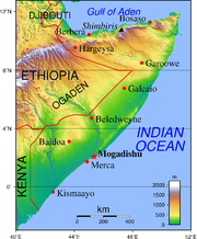 Physiographically, Somalia is a land of limited contrast. In the north, a maritime semidesert plain parallels the Gulf of Aden coast, varying in width from roughly twelve kilometers in the west to as little as two kilometers in the east. Scrub-covered and generally drab, this plain, known as the Guban
(scrub land), is crossed by broad, shallow watercourses that are beds of dry sand except in the rainy seasons. When the rains arrive, the vegetation, which is a combination of low bushes and grass clumps, is quickly renewed, and for a time the guban provides some grazing for nomad livestock. This coastal strip is part of the Ethiopian xeric grasslands and shrublands
ecoregion
.
Inland from the gulf coast, the plain rises to the precipitous northward-facing cliffs of the dissected highlands. These form the rugged Karkaar mountain ranges that extend from the northwestern border with Ethiopia eastward to the tip of the Horn of Africa, where they end in sheer cliffs at Caseyr. The general elevation along the crest of these mountains averages about 1,800 meters above sea level south of the port town of Berbera
, and eastward from that area it continues at 1,800 to 2,100 meters almost to Caseyr. The country's highest point, Shimber Berris, which rises to 2,407 meters, is located near the town of Erigavo.
Southward the mountains descend, often in scarped ledges, to an elevated plateau devoid of perennial rivers. This region of broken mountain terrain, shallow plateau valleys, and usually dry watercourses is known to the Somalis as the Ogo.
In the Ogo's especially arid eastern part, the plateau—broken by several isolated mountain ranges—gradually slopes toward the Indian Ocean
and in central Somalia constitutes the Mudug
Plain. A major feature of this eastern section is the long and broad Nugaal
Valley, with its extensive network of intermittent seasonal watercourses. The Nugaal river enters the Indian Ocean at Eyl
. The eastern area's population consists mainly of pastoral nomads eking a living in a zone of low and erratic rainfall.
The western part of the Ogo plateau region is crossed by numerous shallow valleys and dry watercourses. Annual rainfall is greater than in the east, and there are flat areas of arable land that provide a home for dryland cultivators. Most important, the western area has permanent wells to which the predominantly nomadic population returns during the dry seasons. The western plateau slopes gently southward and merges imperceptibly into an area known as the Haud
, a broad, undulating terrain that constitutes some of the best grazing lands for Somali nomads, despite the lack of appreciable rainfall more than half the year. Enhancing the value of the Haud are the natural depressions that during periods of rain become temporary lakes and ponds.
The Haud zone continues for more than sixty kilometers into Ethiopia, and the vast Somali Plateau, which lies between the northern Somali mountains and the highlands of southeast Ethiopia, extends south and eastward through Ethiopia into central and southwest Somalia. The portion of the Haud lying within Ethiopia was the subject of an agreement made during the colonial era. In 1948, under pressure from their World War II allies and to the dismay of the Somalis, the British "returned" the Haud (an important Somali grazing area that was presumably 'protected' by British treaties with the Somalis in 1884 and 1886) and the Ogaden
to Ethiopia, based on an 1897 treaty
in which the British ceded Somali territory to the Ethiopian Emperor Menelik
in exchange for his help against plundering by Somali clan
s. Britain included the proviso that the Somali nomads would retain their autonomy, but Ethiopia immediately claimed sovereignty over them. This prompted an unsuccessful bid by Britain in 1956 to buy back the Somali lands it had turned over. The stretch of land has since been a considerable source of regional strife.
Southwestern Somalia is dominated by the country's only two permanent rivers, the Jubba
and the Shabeelle. With their sources in the Ethiopian highlands, these rivers flow in a generally southerly direction, cutting wide valleys in the Somali Plateau as it descends toward the sea; the plateau's elevation falls off rapidly in this area. The adjacent coastal zone, which includes the lower reaches of the rivers and extends from the Mudug Plain to the Kenya
n border, averages 180 meters above sea level.
The Jubba River enters the Indian Ocean at Kismaayo. Although the Shabeelle River at one time apparently also reached the sea near Merca
, its course is thought to have changed in prehistoric times. The Shabeelle now turns southwestward near Balcad
(about thirty kilometers north of Mogadishu
) and parallels the coast for more than eighty-five kilometers. The river is perennial only to a point southwest of Mogadishu; thereafter it consists of swampy areas and dry reaches and is finally lost in the sand east of Jilib
, not far from the Jubba River. During the flood seasons, the Shabeelle River may fill its bed to a point near Jilib and occasionally may even break through to the Jubba River farther south. Favorable rainfall and soil conditions make the entire riverine region a fertile agricultural area and the center of the country's largest sedentary population.
In most of northern, northeastern, and north-central Somalia, where rainfall is low, the vegetation consists of scattered low trees, including various acacias, and widely scattered patches of grass. This vegetation gives way to a combination of low bushes and grass clumps in the highly arid areas of the northeast and along the Gulf of Aden.
As elevations and rainfall increase in the maritime ranges of the north, the vegetation becomes denser. Aloe
s are common, and on the higher plateau areas of the Ogo are woodlands. At a few places above 1,500 meters, the remnants of juniper
forests (protected by the state) and areas of Euphorbia candelabrum
(a chandelier-type spiny plant) occur. In the more arid highlands of the northeast, Boswellia
and Commiphora
trees are sources, respectively, of the frankincense
and myrrh
for which Somalia has been known since ancient times.
 A broad plateau encompassing the northern city of Hargeysa
, which receives comparatively heavy rainfall, is covered naturally by woodland (much of which has been degraded by overgrazing) and in places by extensive grasslands. Parts of this area have been under cultivation since the 1930s, producing sorghum
and maize
; in the 1990s it constituted the only significant region of sedentary cultivation outside southwestern Somalia.
The Haud south of Hargeysa is covered mostly by a semiarid woodland of scattered trees, mainly acacia
s, underlain by grasses that include species especially favored by livestock as forage. There vegetation forms spatially periodic patterns reminiscent of a tiger skin when viewed from above and therefore knowns as "Tiger bush
". As the Haud merges into the Mudug Plain in central Somalia, the aridity increases and the vegetation takes on a subdesert character. Farther southward the terrain gradually changes to semiarid woodlands and grasslands as the annual precipitation increases.
The region encompassing the Shabeelle and Jubba rivers is relatively well watered and constitutes the country's most arable zone. The lowland between the rivers supports rich pasturage. It features arid to subarid savanna, open woodland, and thickets that include frequently abundant underlying grasses. There are areas of grassland, and in the far southwest, near the Kenyan border, some dry evergreen forests are found.
Along the Indian Ocean from Hobyo
southwestward to near Mogadishu lies a stretch of dry coastal sand dunes, the Hobyo grasslands and shrublands ecoregion
. This area is covered with scattered scrub and grass clumps where rainfall is sufficient although unpredictable. Much of this coast is thinly populated but overgrazing, particularly south of Mogadishu, has resulted in the destruction of the protective vegetation cover and the gradual movement of the once-stationary dunes inland. The original flora of this coast contains a number of endemic species and beginning in the early 1970s, efforts were made to stabilize these dunes by replanting. Endemic mammals are the Silver Dik-dik
(Madoqua piacentinii), one of the world's smallest antelopes, and the Somali golden mole
(Calcochloris tytonis). Other endemic species include two reptiles, a skink
Haackgreerius miopus and a lizard Latastia cherchii and two birds, Ash's Lark
(Mirafra ashi) and the Obbia Lark
(Spizocorys obbiensis). The longterm political strife in Somalia has meant the coast is poorly studied and the state of the habitat unknown.
Other vegetation includes plants and grasses found in the swamps into which the Shabeelle River empties most of the year and in other large swamps in the course of the lower Jubba River. Swamps of East African mangroves
are found at points along the coast, particularly from Kismaayo to near the Kenyan border. Uncontrolled exploitation appears to have caused some damage to forests in that area. Other mangroves are located near Mogadishu and at a number of places along the northeastern and northern coasts.
East Africa, bordering the Gulf of Aden
and the Indian Ocean
, east of Ethiopia
Geographic coordinates:
10°00′N 49°00′E
Map references:
Africa
Area:
total:
637,657 km²
land:
627,337 km²
water:
10,320 km²
Area - comparative:
slightly smaller than Texas
Land boundaries:
total:
2,366 km
border countries:
Djibouti
58 km, Ethiopia
1,626 km, Kenya
682 km
Coastline:
3,300 km
Maritime claims:
territorial sea:
200 nmi (370.4 km; 230.2 mi)
Climate:
principally desert; December to February - northeast monsoon, moderate temperatures in north and very hot in south; May to October - southwest monsoon, torrid in the north and hot in the south, irregular rainfall, hot and humid periods (tangambili) between monsoons
Terrain:
mostly flat to undulating plateau rising to hills in north
Elevation extremes:
lowest point:
Indian Ocean 0 m
highest point:
Shimbiris
2,416 m
Natural resources:
uranium and largely unexploited reserves of iron ore, tin, gypsum, bauxite, copper, salt
Land use:
arable land:
2%
permanent crops:
0%
permanent pastures:
69%
forests and woodland:
26%
other:
3% (1993 est.)
Irrigated land:
1,800 km² (1993 est.)
Natural hazards:
recurring droughts; frequent dust storms over eastern plains in summer; floods during rainy season
Environment - current issues:
famine; use of contaminated water contributes to human health problems; deforestation; overgrazing; soil erosion; desertification
Environment - international agreements:
party to:
Endangered Species, Law of the Sea
signed, but not ratified:
Marine Dumping, Nuclear Test Ban
Geography - note:
strategic location on Horn of Africa
along southern approaches to Bab el Mandeb and route through Red Sea
and Suez Canal
, the points that are farther north, south, east or west than any other location.
Somalia
Somalia , officially the Somali Republic and formerly known as the Somali Democratic Republic under Socialist rule, is a country located in the Horn of Africa. Since the outbreak of the Somali Civil War in 1991 there has been no central government control over most of the country's territory...
has a land area of 637,540 square kilometers. Somalia occupies the tip of a region commonly referred to as the Horn of Africa
Horn of Africa
The Horn of Africa is a peninsula in East Africa that juts hundreds of kilometers into the Arabian Sea and lies along the southern side of the Gulf of Aden. It is the easternmost projection of the African continent...
(because of its resemblance on the map to a rhinoceros' horn) that also includes Ethiopia
Ethiopia
Ethiopia , officially known as the Federal Democratic Republic of Ethiopia, is a country located in the Horn of Africa. It is the second-most populous nation in Africa, with over 82 million inhabitants, and the tenth-largest by area, occupying 1,100,000 km2...
, Eritrea
Eritrea
Eritrea , officially the State of Eritrea, is a country in the Horn of Africa. Eritrea derives it's name from the Greek word Erethria, meaning 'red land'. The capital is Asmara. It is bordered by Sudan in the west, Ethiopia in the south, and Djibouti in the southeast...
and Djibouti
Djibouti
Djibouti , officially the Republic of Djibouti , is a country in the Horn of Africa. It is bordered by Eritrea in the north, Ethiopia in the west and south, and Somalia in the southeast. The remainder of the border is formed by the Red Sea and the Gulf of Aden at the east...
. Somalia's terrain consists mainly of plateau
Plateau
In geology and earth science, a plateau , also called a high plain or tableland, is an area of highland, usually consisting of relatively flat terrain. A highly eroded plateau is called a dissected plateau...
s, plain
Plain
In geography, a plain is land with relatively low relief, that is flat or gently rolling. Prairies and steppes are types of plains, and the archetype for a plain is often thought of as a grassland, but plains in their natural state may also be covered in shrublands, woodland and forest, or...
s, and highlands. In the far north, however, the rugged east-west ranges of the Karkaar Mountains lie at varying distances from the Gulf of Aden
Gulf of Aden
The Gulf of Aden is located in the Arabian Sea between Yemen, on the south coast of the Arabian Peninsula, and Somalia in the Horn of Africa. In the northwest, it connects with the Red Sea through the Bab-el-Mandeb strait, which is about 20 miles wide....
coast. The weather is hot throughout the year, except at the higher elevations in the north. Rainfall is sparse, and most of Somalia has a semiarid-to- arid environment suitable only for the nomadic pastoralism practiced by well over half the population. Only in limited areas of moderate rainfall in the northwest, and particularly in the southwest, where the country's two perennial rivers are found, is agriculture practiced to any extent.
The local geology suggests the presence of valuable mineral deposits. Somalia's long coastline, more than 3,300 kilometers, the longest coastline of Africa
Africa
Africa is the world's second largest and second most populous continent, after Asia. At about 30.2 million km² including adjacent islands, it covers 6% of the Earth's total surface area and 20.4% of the total land area...
and the Middle East
Middle East
The Middle East is a region that encompasses Western Asia and Northern Africa. It is often used as a synonym for Near East, in opposition to Far East...
. has been of importance chiefly in permitting trade with the Middle East
Middle East
The Middle East is a region that encompasses Western Asia and Northern Africa. It is often used as a synonym for Near East, in opposition to Far East...
and the rest of the Horn of Africa.
Climate
Due to Somalia's proximity to the equatorEquator
An equator is the intersection of a sphere's surface with the plane perpendicular to the sphere's axis of rotation and containing the sphere's center of mass....
, there is not much seasonal variation in its climate. However, there are some very unpredictable rainfalls that occur sometimes. Hot conditions prevail year-round along with periodic monsoon
Monsoon
Monsoon is traditionally defined as a seasonal reversing wind accompanied by corresponding changes in precipitation, but is now used to describe seasonal changes in atmospheric circulation and precipitation associated with the asymmetric heating of land and sea...
winds and irregular rainfall. Mean daily maximum temperatures range from 30 to 40 °C (86 to 104 °F), except at higher elevations and along the eastern seaboard, where the effects of a cold offshore current can be felt. In Mogadishu, for instance, average afternoon highs range from 28 °C (82.4 °F) to 32 °C (89.6 °F) in April. Some of the highest mean annual temperatures in the world have been recorded in the country; Berbera
Berbera
Berbera is a city and seat of Berbera District in Somaliland, a self-proclaimed Independent Republic with de facto control over its own territory, which is recognized by the international community and the Somali Government as a part of Somalia...
on the northwestern coast has an afternoon high that averages more than 38 °C (100.4 °F) from June through September. Nationally, mean daily minimums usually vary from about 15 to 30 °C (59 to 86 °F). The greatest range in climate occurs in northern Somalia, where temperatures sometimes surpass 45 °C (113 °F) in July on the littoral plains and drop below the freezing point during December in the highlands. In this region, relative humidity ranges from about 40 percent in the mid-afternoon to 85 percent at night, changing somewhat according to the season.
Unlike the climates of most other countries at this latitude, conditions in Somalia range from arid
Arid
A region is said to be arid when it is characterized by a severe lack of available water, to the extent of hindering or even preventing the growth and development of plant and animal life...
in the northeastern and central regions to semiarid in the northwest and south. In the northeast, annual rainfall is less than 4 inches (101.6 mm); in the central plateaus, it is about 8 to 12 in (203.2 to 304.8 mm). The northwestern and southwestern parts of the nation, however, receive considerably more rain, with an average of 20 to 24 in (508 to 609.6 mm) falling per year. Although the coastal regions are hot and humid throughout the year, the hinterland is typically dry and hot.
Most of the country receives less than 500 millimetres (19.7 in) of rain annually, and a large area encompassing the northeast and much of northern Somalia receives as little as 50 to 150 mm (2 to 5.9 in). Certain higher areas in the north, however, record more than 500 millimetres (19.7 in) a year, as do some coastal sites. The southwest receives 330 to 500 mm (13 to 19.7 in). Generally, rainfall takes the form of showers or localized torrential rains and is extremely variable. Mean daily maximum temperatures throughout the country range from 30 to 40 °C (86 to 104 °F), except at higher elevations and along the Indian Ocean coast. Mean daily minimum temperatures vary from 20 °C (68 °F) to more than 30 °C (86 °F). Northern Somalia experiences the greatest temperature extremes, with readings ranging from below freezing in the highlands in December to more than 45 °C (113 °F) in July in the coastal plain skirting the Gulf of Aden. The north's relative humidity ranges from about 40 percent in midafternoon to 85 percent at night, varying somewhat with the season. During the colder months, December to February, visibility at higher elevations is often restricted by fog. Temperatures in the south are less extreme, ranging from about 20 to 40 °C (68 to 104 °F). The hottest months are February through April. Coastal readings are usually five to ten degrees cooler than those inland. The coastal zone's relative humidity usually remains about 70 percent even during the dry seasons.
There are four main seasons around which pastoral and agricultural life revolve, and these are dictated by shifts in the wind patterns. From December to March is the Jilal, the harshest dry season of the year. The main rainy season, referred to as the Gu, lasts from April to June. This period is characterized by the southwest monsoons, which rejuvenate the pasture land, especially the central plateau, and briefly transform the desert into lush vegetation. From July to September is the second dry season, the Xagaa . The Dayr, which is the shortest rainy season, lasts from October to December. The tangambili periods that intervene between the two monsoons (October–November and March–May) are hot and humid.
Terrain, Vegetation, and Drainage
Guban
The Guban is a plain in northwestern Somalia. It is situated on the coast between Zeila and Berbera.-References:*Hadden, Robert Lee. 2007. Engineer Research and Development Laboratories, Topographic Engineering Center...
(scrub land), is crossed by broad, shallow watercourses that are beds of dry sand except in the rainy seasons. When the rains arrive, the vegetation, which is a combination of low bushes and grass clumps, is quickly renewed, and for a time the guban provides some grazing for nomad livestock. This coastal strip is part of the Ethiopian xeric grasslands and shrublands
Ethiopian xeric grasslands and shrublands
The Ethiopian xeric grasslands and shrublands ecoregion is a semi-desert strip on or near the Red Sea and the Gulf of Oman coasts in Eritrea, Ethiopia, Djibouti and Somaliland.-Location and description:...
ecoregion
Ecoregion
An ecoregion , sometimes called a bioregion, is an ecologically and geographically defined area that is smaller than an ecozone and larger than an ecosystem. Ecoregions cover relatively large areas of land or water, and contain characteristic, geographically distinct assemblages of natural...
.
Inland from the gulf coast, the plain rises to the precipitous northward-facing cliffs of the dissected highlands. These form the rugged Karkaar mountain ranges that extend from the northwestern border with Ethiopia eastward to the tip of the Horn of Africa, where they end in sheer cliffs at Caseyr. The general elevation along the crest of these mountains averages about 1,800 meters above sea level south of the port town of Berbera
Berbera
Berbera is a city and seat of Berbera District in Somaliland, a self-proclaimed Independent Republic with de facto control over its own territory, which is recognized by the international community and the Somali Government as a part of Somalia...
, and eastward from that area it continues at 1,800 to 2,100 meters almost to Caseyr. The country's highest point, Shimber Berris, which rises to 2,407 meters, is located near the town of Erigavo.
Southward the mountains descend, often in scarped ledges, to an elevated plateau devoid of perennial rivers. This region of broken mountain terrain, shallow plateau valleys, and usually dry watercourses is known to the Somalis as the Ogo.
In the Ogo's especially arid eastern part, the plateau—broken by several isolated mountain ranges—gradually slopes toward the Indian Ocean
Indian Ocean
The Indian Ocean is the third largest of the world's oceanic divisions, covering approximately 20% of the water on the Earth's surface. It is bounded on the north by the Indian Subcontinent and Arabian Peninsula ; on the west by eastern Africa; on the east by Indochina, the Sunda Islands, and...
and in central Somalia constitutes the Mudug
Mudug
Mudug is an administrative region in north-central Somalia. Bordered by the Ogaden, the Somalian regions of Nugaal and Galguduud, and the Indian Ocean, its capital is the city of Galkacyo.-Districts:...
Plain. A major feature of this eastern section is the long and broad Nugaal
Nugaal
Nugal is an administrative region in northeastern Somalia.-Overview:It is bordered by Ethiopia and the Somalian regions of Sool to the west, Bari to the north, and Mudug to the south, with the Indian Ocean to the east....
Valley, with its extensive network of intermittent seasonal watercourses. The Nugaal river enters the Indian Ocean at Eyl
Eyl
Eyl is an ancient town in the northern Puntland region of Somalia. It is situated near the Hafun peninsula.-History:Eyl is the site of many historical artifacts from Somalia's pre-colonial period...
. The eastern area's population consists mainly of pastoral nomads eking a living in a zone of low and erratic rainfall.
The western part of the Ogo plateau region is crossed by numerous shallow valleys and dry watercourses. Annual rainfall is greater than in the east, and there are flat areas of arable land that provide a home for dryland cultivators. Most important, the western area has permanent wells to which the predominantly nomadic population returns during the dry seasons. The western plateau slopes gently southward and merges imperceptibly into an area known as the Haud
Haud
Haud is a region of thorn-bush and grasslands in the Horn of Africa, which includes the northeastern part of the Ogaden territory of Ethiopia, as well the adjacent parts of Somalia. The Haud is of indeterminate extent; some authorities consider it denotes the part of Ethiopia east of the city of...
, a broad, undulating terrain that constitutes some of the best grazing lands for Somali nomads, despite the lack of appreciable rainfall more than half the year. Enhancing the value of the Haud are the natural depressions that during periods of rain become temporary lakes and ponds.
The Haud zone continues for more than sixty kilometers into Ethiopia, and the vast Somali Plateau, which lies between the northern Somali mountains and the highlands of southeast Ethiopia, extends south and eastward through Ethiopia into central and southwest Somalia. The portion of the Haud lying within Ethiopia was the subject of an agreement made during the colonial era. In 1948, under pressure from their World War II allies and to the dismay of the Somalis, the British "returned" the Haud (an important Somali grazing area that was presumably 'protected' by British treaties with the Somalis in 1884 and 1886) and the Ogaden
Ogaden
Ogaden is the name of a territory comprising the southeastern portion of the Somali Regional State in Ethiopia. The inhabitants are predominantly ethnic Somali and Muslim. The title "Somali Galbeed", which means "Western Somalia," is often preferred by Somali irredentists.The region, which is...
to Ethiopia, based on an 1897 treaty
Anglo-Ethiopian Treaty of 1897
The Anglo-Ethiopian Treaty of 1897 was an agreement negotiated between diplomat Sir Rennell Rodd of Great Britain and Emperor Menelik II of Ethiopia primarily involving border issues between Ethiopia and colonial British Somaliland...
in which the British ceded Somali territory to the Ethiopian Emperor Menelik
Ménélik
Ménélik, now MNLK , is a French rapper.-Biography:He went to France at the age of nine. Then he met MC Solaar and started to write songs for artists such as No Sé, DJ Jimmy Jay and RPM. In 1995, he released his first album entitled Phenomenelik and participated in Solaar's concerts...
in exchange for his help against plundering by Somali clan
Somali clan
The demographics of Somalia describes the condition and overview of Somalia's inhabitants. Demographic topics include basic education, health and population statistics, as well as identified racial and religious affiliations.-Somalis:...
s. Britain included the proviso that the Somali nomads would retain their autonomy, but Ethiopia immediately claimed sovereignty over them. This prompted an unsuccessful bid by Britain in 1956 to buy back the Somali lands it had turned over. The stretch of land has since been a considerable source of regional strife.
Southwestern Somalia is dominated by the country's only two permanent rivers, the Jubba
Jubba River
The Jubba River is a river in southern Somalia. It begins at the border with Ethiopia, where the Dawa and Ganale Dorya rivers meet, and flows directly south to the Indian Ocean, where it empties at the Goobweyn juncture.-History:...
and the Shabeelle. With their sources in the Ethiopian highlands, these rivers flow in a generally southerly direction, cutting wide valleys in the Somali Plateau as it descends toward the sea; the plateau's elevation falls off rapidly in this area. The adjacent coastal zone, which includes the lower reaches of the rivers and extends from the Mudug Plain to the Kenya
Kenya
Kenya , officially known as the Republic of Kenya, is a country in East Africa that lies on the equator, with the Indian Ocean to its south-east...
n border, averages 180 meters above sea level.
The Jubba River enters the Indian Ocean at Kismaayo. Although the Shabeelle River at one time apparently also reached the sea near Merca
Merca
Merca is a port city on the coast of southern Somalia, facing the Indian Ocean. It is the main town in the Shabeellaha Hoose region, and is located approximately southwest of the nation's capital, Mogadishu.-History:...
, its course is thought to have changed in prehistoric times. The Shabeelle now turns southwestward near Balcad
Balcad
Balcad , or Bal'ad, is a town in the southeastern Shabeellaha Hoose region of Somalia. It is situated in the Balcad District.-References:*...
(about thirty kilometers north of Mogadishu
Mogadishu
Mogadishu , popularly known as Xamar, is the largest city in Somalia and the nation's capital. Located in the coastal Benadir region on the Indian Ocean, the city has served as an important port for centuries....
) and parallels the coast for more than eighty-five kilometers. The river is perennial only to a point southwest of Mogadishu; thereafter it consists of swampy areas and dry reaches and is finally lost in the sand east of Jilib
Jilib
Jilib is a town in Somalia, with an estimated population of approximately 45,000. It is located on the main road from Mogadishu south to Kismayo and is the most populous town in the Middle Juba Region.The Islamic Courts Union was defeated there in the Battle of Jilib December 2006 January 2007...
, not far from the Jubba River. During the flood seasons, the Shabeelle River may fill its bed to a point near Jilib and occasionally may even break through to the Jubba River farther south. Favorable rainfall and soil conditions make the entire riverine region a fertile agricultural area and the center of the country's largest sedentary population.
In most of northern, northeastern, and north-central Somalia, where rainfall is low, the vegetation consists of scattered low trees, including various acacias, and widely scattered patches of grass. This vegetation gives way to a combination of low bushes and grass clumps in the highly arid areas of the northeast and along the Gulf of Aden.
As elevations and rainfall increase in the maritime ranges of the north, the vegetation becomes denser. Aloe
Aloe
Aloe , also Aloë, is a genus containing about 500 species of flowering succulent plants. The most common and well known of these is Aloe vera, or "true aloe"....
s are common, and on the higher plateau areas of the Ogo are woodlands. At a few places above 1,500 meters, the remnants of juniper
Juniper
Junipers are coniferous plants in the genus Juniperus of the cypress family Cupressaceae. Depending on taxonomic viewpoint, there are between 50-67 species of juniper, widely distributed throughout the northern hemisphere, from the Arctic, south to tropical Africa in the Old World, and to the...
forests (protected by the state) and areas of Euphorbia candelabrum
Euphorbia candelabrum
Euphorbia candelabrum is a succulent species of plant in the Euphorbiaceae family. Its Latin name derives from its growth habit, often considered to resemble the branching of a candelabrum. E. candelabrum is endemic to the Horn of Africa and eastern Africa along the Great Rift Valley system...
(a chandelier-type spiny plant) occur. In the more arid highlands of the northeast, Boswellia
Boswellia
Boswellia is a genus of trees known for their fragrant resin which has many pharmacological uses particularly as anti-inflammatories. The Biblical incense frankincense was probably an extract from the resin of the tree, Boswellia sacra....
and Commiphora
Commiphora
Commiphora is a genus of flowering plants in the family Burseraceae. It includes about 185 species of trees and shrubs, often armed or thorny, native to Africa, Arabia, and the Indian subcontinent.-Uses:...
trees are sources, respectively, of the frankincense
Frankincense
Frankincense, also called olibanum , is an aromatic resin obtained from trees of the genus Boswellia, particularly Boswellia sacra, B. carteri, B. thurifera, B. frereana, and B. bhaw-dajiana...
and myrrh
Myrrh
Myrrh is the aromatic oleoresin of a number of small, thorny tree species of the genus Commiphora, which grow in dry, stony soil. An oleoresin is a natural blend of an essential oil and a resin. Myrrh resin is a natural gum....
for which Somalia has been known since ancient times.
Hargeisa
Hargeisa is a city in the northwestern Woqooyi Galbeed region of Somalia. With a population of approximately 2 million residents, it is the second largest city in the country. Hargeisa is the capital of Somaliland, a self-declared republic that is internationally recognized as an autonomous region...
, which receives comparatively heavy rainfall, is covered naturally by woodland (much of which has been degraded by overgrazing) and in places by extensive grasslands. Parts of this area have been under cultivation since the 1930s, producing sorghum
Sorghum
Sorghum is a genus of numerous species of grasses, one of which is raised for grain and many of which are used as fodder plants either cultivated or as part of pasture. The plants are cultivated in warmer climates worldwide. Species are native to tropical and subtropical regions of all continents...
and maize
Maize
Maize known in many English-speaking countries as corn or mielie/mealie, is a grain domesticated by indigenous peoples in Mesoamerica in prehistoric times. The leafy stalk produces ears which contain seeds called kernels. Though technically a grain, maize kernels are used in cooking as a vegetable...
; in the 1990s it constituted the only significant region of sedentary cultivation outside southwestern Somalia.
The Haud south of Hargeysa is covered mostly by a semiarid woodland of scattered trees, mainly acacia
Acacia
Acacia is a genus of shrubs and trees belonging to the subfamily Mimosoideae of the family Fabaceae, first described in Africa by the Swedish botanist Carl Linnaeus in 1773. Many non-Australian species tend to be thorny, whereas the majority of Australian acacias are not...
s, underlain by grasses that include species especially favored by livestock as forage. There vegetation forms spatially periodic patterns reminiscent of a tiger skin when viewed from above and therefore knowns as "Tiger bush
Tiger bush
Tiger bush is a patterned vegetation community consisting of alternating bands of trees or shrubs, separated by bare ground or low herb cover, that run roughly parallel to contour lines of equal elevation...
". As the Haud merges into the Mudug Plain in central Somalia, the aridity increases and the vegetation takes on a subdesert character. Farther southward the terrain gradually changes to semiarid woodlands and grasslands as the annual precipitation increases.
The region encompassing the Shabeelle and Jubba rivers is relatively well watered and constitutes the country's most arable zone. The lowland between the rivers supports rich pasturage. It features arid to subarid savanna, open woodland, and thickets that include frequently abundant underlying grasses. There are areas of grassland, and in the far southwest, near the Kenyan border, some dry evergreen forests are found.
Along the Indian Ocean from Hobyo
Hobyo
Hobyo is an ancient harbor city in the Mudug region of Somalia. Hobyo literally means "here, water", and the plentiful fresh water to be had from the wells in and around the town has been the driving force behind Hobyo's ancient status as a favorite port-of-call for sailors.-Establishment:Hobyo's...
southwestward to near Mogadishu lies a stretch of dry coastal sand dunes, the Hobyo grasslands and shrublands ecoregion
Ecoregion
An ecoregion , sometimes called a bioregion, is an ecologically and geographically defined area that is smaller than an ecozone and larger than an ecosystem. Ecoregions cover relatively large areas of land or water, and contain characteristic, geographically distinct assemblages of natural...
. This area is covered with scattered scrub and grass clumps where rainfall is sufficient although unpredictable. Much of this coast is thinly populated but overgrazing, particularly south of Mogadishu, has resulted in the destruction of the protective vegetation cover and the gradual movement of the once-stationary dunes inland. The original flora of this coast contains a number of endemic species and beginning in the early 1970s, efforts were made to stabilize these dunes by replanting. Endemic mammals are the Silver Dik-dik
Silver Dik-dik
The Silver Dik-dik is a small antelope found in low, dense thickets along the southeastern coast of Somalia and in Acacia-Commiphora bushland in the Shebelle Valley in southeastern Ethiopia. It is the smallest species of dik-dik with a length of , a height of and a weight of...
(Madoqua piacentinii), one of the world's smallest antelopes, and the Somali golden mole
Somali Golden Mole
The Somali Golden Mole is a golden mole endemic to Somalia....
(Calcochloris tytonis). Other endemic species include two reptiles, a skink
Skink
Skinks are lizards belonging to the family Scincidae. Together with several other lizard families, including Lacertidae , they comprise the superfamily or infraorder Scincomorpha...
Haackgreerius miopus and a lizard Latastia cherchii and two birds, Ash's Lark
Ash's Lark
The Ash's Lark is a species of lark in the Alaudidae family.It is endemic to Somalia.- Identification :In the case of some lark species, as with Ash's Lark it is hard to describe definitively without having to compare its characters with those of some of its close relatives...
(Mirafra ashi) and the Obbia Lark
Obbia Lark
The Obbia Lark is a species of lark in the Alaudidae family. It is endemic to Somalia. Its natural habitat is subtropical or tropical dry shrubland.-References:...
(Spizocorys obbiensis). The longterm political strife in Somalia has meant the coast is poorly studied and the state of the habitat unknown.
Other vegetation includes plants and grasses found in the swamps into which the Shabeelle River empties most of the year and in other large swamps in the course of the lower Jubba River. Swamps of East African mangroves
East African mangroves
The East African mangroves are an ecoregion consisting of mangrove swamps along the Indian Ocean coast of East Africa in southern Mozambique, Tanzania, Kenya and southern Somalia.-Location and description:...
are found at points along the coast, particularly from Kismaayo to near the Kenyan border. Uncontrolled exploitation appears to have caused some damage to forests in that area. Other mangroves are located near Mogadishu and at a number of places along the northeastern and northern coasts.
Data
Location:East Africa, bordering the Gulf of Aden
Gulf of Aden
The Gulf of Aden is located in the Arabian Sea between Yemen, on the south coast of the Arabian Peninsula, and Somalia in the Horn of Africa. In the northwest, it connects with the Red Sea through the Bab-el-Mandeb strait, which is about 20 miles wide....
and the Indian Ocean
Indian Ocean
The Indian Ocean is the third largest of the world's oceanic divisions, covering approximately 20% of the water on the Earth's surface. It is bounded on the north by the Indian Subcontinent and Arabian Peninsula ; on the west by eastern Africa; on the east by Indochina, the Sunda Islands, and...
, east of Ethiopia
Ethiopia
Ethiopia , officially known as the Federal Democratic Republic of Ethiopia, is a country located in the Horn of Africa. It is the second-most populous nation in Africa, with over 82 million inhabitants, and the tenth-largest by area, occupying 1,100,000 km2...
Geographic coordinates:
10°00′N 49°00′E
Map references:
Africa
Area:
total:
637,657 km²
land:
627,337 km²
water:
10,320 km²
Area - comparative:
slightly smaller than Texas
Land boundaries:
total:
2,366 km
border countries:
Djibouti
Djibouti
Djibouti , officially the Republic of Djibouti , is a country in the Horn of Africa. It is bordered by Eritrea in the north, Ethiopia in the west and south, and Somalia in the southeast. The remainder of the border is formed by the Red Sea and the Gulf of Aden at the east...
58 km, Ethiopia
Ethiopia
Ethiopia , officially known as the Federal Democratic Republic of Ethiopia, is a country located in the Horn of Africa. It is the second-most populous nation in Africa, with over 82 million inhabitants, and the tenth-largest by area, occupying 1,100,000 km2...
1,626 km, Kenya
Kenya
Kenya , officially known as the Republic of Kenya, is a country in East Africa that lies on the equator, with the Indian Ocean to its south-east...
682 km
Coastline:
3,300 km
Maritime claims:
territorial sea:
200 nmi (370.4 km; 230.2 mi)
Climate:
principally desert; December to February - northeast monsoon, moderate temperatures in north and very hot in south; May to October - southwest monsoon, torrid in the north and hot in the south, irregular rainfall, hot and humid periods (tangambili) between monsoons
Terrain:
mostly flat to undulating plateau rising to hills in north
Elevation extremes:
lowest point:
Indian Ocean 0 m
highest point:
Shimbiris
Shimbiris
Mount Shimbiris is the highest peak in Somalia. It sits at an altitude of above sea level. It is located in the Cal Madow mountain range in northern Somalia, in the Sanaag region. SRTM data shows that its often quoted elevation of 2,410m is slightly low....
2,416 m
Natural resources:
uranium and largely unexploited reserves of iron ore, tin, gypsum, bauxite, copper, salt
Land use:
arable land:
2%
permanent crops:
0%
permanent pastures:
69%
forests and woodland:
26%
other:
3% (1993 est.)
Irrigated land:
1,800 km² (1993 est.)
Natural hazards:
recurring droughts; frequent dust storms over eastern plains in summer; floods during rainy season
Environment - current issues:
famine; use of contaminated water contributes to human health problems; deforestation; overgrazing; soil erosion; desertification
Environment - international agreements:
party to:
Endangered Species, Law of the Sea
signed, but not ratified:
Marine Dumping, Nuclear Test Ban
Geography - note:
strategic location on Horn of Africa
Horn of Africa
The Horn of Africa is a peninsula in East Africa that juts hundreds of kilometers into the Arabian Sea and lies along the southern side of the Gulf of Aden. It is the easternmost projection of the African continent...
along southern approaches to Bab el Mandeb and route through Red Sea
Red Sea
The Red Sea is a seawater inlet of the Indian Ocean, lying between Africa and Asia. The connection to the ocean is in the south through the Bab el Mandeb strait and the Gulf of Aden. In the north, there is the Sinai Peninsula, the Gulf of Aqaba, and the Gulf of Suez...
and Suez Canal
Suez Canal
The Suez Canal , also known by the nickname "The Highway to India", is an artificial sea-level waterway in Egypt, connecting the Mediterranean Sea and the Red Sea. Opened in November 1869 after 10 years of construction work, it allows water transportation between Europe and Asia without navigation...
Extreme points
This is a list of the extreme points of SomaliaSomalia
Somalia , officially the Somali Republic and formerly known as the Somali Democratic Republic under Socialist rule, is a country located in the Horn of Africa. Since the outbreak of the Somali Civil War in 1991 there has been no central government control over most of the country's territory...
, the points that are farther north, south, east or west than any other location.
- Northern-most point - Ras Illaue, Bari region
- Eastern-most point - Ras Hafun, Bari region*
- Southern-most point - the point at which the border with KenyaKenyaKenya , officially known as the Republic of Kenya, is a country in East Africa that lies on the equator, with the Indian Ocean to its south-east...
enters the Indian OceanIndian OceanThe Indian Ocean is the third largest of the world's oceanic divisions, covering approximately 20% of the water on the Earth's surface. It is bounded on the north by the Indian Subcontinent and Arabian Peninsula ; on the west by eastern Africa; on the east by Indochina, the Sunda Islands, and...
, Jubbada HooseJubbada HooseLower Juba is an administrative region in southern Somalia. With its capital at Kismayo, it lies in the Jubaland autonomous region.Lower Juba is bordered by Kenya, the Somalian regions of Gedo, Middle Juba, and the Indian Ocean...
region - Western-most point - the western section of the Kenyan border**
- * This is also the eastern-most point of the African continent
- ** Somalia does not have a western-most point, the western section of the border being formed by the 41° longitude
General references
- Hadden, Robert Lee. 2007. "The Geology of Somalia: A Selected Bibliography of Somalian Geology, Geography and Earth Science." Engineer Research and Development Laboratories, Topographic Engineering Center (now known as the Army Geospatial CenterArmy Geospatial CenterThe Army Geospatial Center is a Major Subordinate Command of the United States Army Corps of Engineers. It is located in Alexandria, Virginia, within the adjacent to the Fort Belvoir military reservation...
, US Army Corps of Engineers), in Alexandria, VA. Includes data and citations on the geology, geography, water and transportation in Somalia.