
Geography of Slovakia
Overview
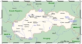
Slovakia
The Slovak Republic is a landlocked state in Central Europe. It has a population of over five million and an area of about . Slovakia is bordered by the Czech Republic and Austria to the west, Poland to the north, Ukraine to the east and Hungary to the south...
is a landlocked Central Europe
Central Europe
Central Europe or alternatively Middle Europe is a region of the European continent lying between the variously defined areas of Eastern and Western Europe...
an country with mountainous regions in the north and flat terrain in the south.
Slovakia lies between 49°36'48" and 47°44'21" northern latitude and 16°50'56" and 22°33'53" eastern longitude.
The northernmost point is near Beskydok, a mountain on the border with Poland near the village of Oravská Polhora
Oravská Polhora
Oravská Polhora is a large village and municipality in Námestovo District in the Žilina Region of northern Slovakia.-History:In historical records the village was first mentioned in 1580....
in the Beskides. The southernmost point is near the village of Patince
Patince
Patince is a village and municipality in the Komárno District in the Nitra Region of south-west Slovakia.-Geography:The village lies at an altitude of 111 metres and covers an area of 11.306 km².It has a population of about 450 people....
on the Danube
Danube
The Danube is a river in the Central Europe and the Europe's second longest river after the Volga. It is classified as an international waterway....
on the border with Hungary.
Unanswered Questions