
Geography of Senegal
Encyclopedia
Senegal
Senegal , officially the Republic of Senegal , is a country in western Africa. It owes its name to the Sénégal River that borders it to the east and north...
is a coastal West Africa
West Africa
West Africa or Western Africa is the westernmost region of the African continent. Geopolitically, the UN definition of Western Africa includes the following 16 countries and an area of approximately 5 million square km:-Flags of West Africa:...
n nation located 14 degrees north
14th parallel north
The 14th parallel north is a circle of latitude that is 14 degrees north of the Earth's equatorial plane. It crosses Africa, Asia, the Indian Ocean, the Pacific Ocean, Central America, the Caribbean and the Atlantic Ocean....
of the Equator
Equator
An equator is the intersection of a sphere's surface with the plane perpendicular to the sphere's axis of rotation and containing the sphere's center of mass....
and 14 degrees west
14th meridian west
The meridian 14° west of Greenwich is a line of longitude that extends from the North Pole across the Arctic Ocean, Greenland, Iceland, the Atlantic Ocean, Africa, the Southern Ocean, and Antarctica to the South Pole....
of the Prime Meridian
Prime Meridian
The Prime Meridian is the meridian at which the longitude is defined to be 0°.The Prime Meridian and its opposite the 180th meridian , which the International Date Line generally follows, form a great circle that divides the Earth into the Eastern and Western Hemispheres.An international...
. The country's total area is 196 190 km² of which 192 000 km² is land and 4 190 km² is water, making the nation slightly smaller than Britain or the U.S. state
U.S. state
A U.S. state is any one of the 50 federated states of the United States of America that share sovereignty with the federal government. Because of this shared sovereignty, an American is a citizen both of the federal entity and of his or her state of domicile. Four states use the official title of...
of South Dakota
South Dakota
South Dakota is a state located in the Midwestern region of the United States. It is named after the Lakota and Dakota Sioux American Indian tribes. Once a part of Dakota Territory, South Dakota became a state on November 2, 1889. The state has an area of and an estimated population of just over...
.
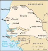
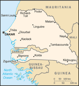
Senegal is bordered to the west by the North Atlantic Ocean
Atlantic Ocean
The Atlantic Ocean is the second-largest of the world's oceanic divisions. With a total area of about , it covers approximately 20% of the Earth's surface and about 26% of its water surface area...
. On land, the nation's longest border is with Mauritania
Mauritania
Mauritania is a country in the Maghreb and West Africa. It is bordered by the Atlantic Ocean in the west, by Western Sahara in the north, by Algeria in the northeast, by Mali in the east and southeast, and by Senegal in the southwest...
to the north, an 813 km border along the Senegal River
Sénégal River
The Sénégal River is a long river in West Africa that forms the border between Senegal and Mauritania.The Sénégal's headwaters are the Semefé and Bafing rivers which both originate in Guinea; they form a small part of the Guinean-Malian border before coming together at Bafoulabé in Mali...
. To the east is the 419 km border with Mali
Mali
Mali , officially the Republic of Mali , is a landlocked country in Western Africa. Mali borders Algeria on the north, Niger on the east, Burkina Faso and the Côte d'Ivoire on the south, Guinea on the south-west, and Senegal and Mauritania on the west. Its size is just over 1,240,000 km² with...
. In the southeast is Guinea
Guinea
Guinea , officially the Republic of Guinea , is a country in West Africa. Formerly known as French Guinea , it is today sometimes called Guinea-Conakry to distinguish it from its neighbour Guinea-Bissau. Guinea is divided into eight administrative regions and subdivided into thirty-three prefectures...
(330 km border) and to the southsouthwest is Guinea-Bissau
Guinea-Bissau
The Republic of Guinea-Bissau is a country in West Africa. It is bordered by Senegal to the north, and Guinea to the south and east, with the Atlantic Ocean to its west....
(338 km), both borders running along the Casamance River
Casamance River
The Casamance River flows westward for the most part into the Atlantic Ocean along a path about 200 miles in length. However, only 80 miles of it are navigable. The Casamance is the principal river of the Kolda, Sédhiou, and Ziguinchor Regions in the southern portion of Senegal between The...
. Senegal is one of only a handful of countries to have a near-enclave within its borders—the small nation of The Gambia
The Gambia
The Republic of The Gambia, commonly referred to as The Gambia, or Gambia , is a country in West Africa. Gambia is the smallest country on mainland Africa, surrounded by Senegal except for a short coastline on the Atlantic Ocean in the west....
in the interior, which has a 740 km border with Senegal. The Gambia penetrates more than 320 km into Senegal, from the Atlantic coast to the center of Senegal along the Gambia River
Gambia River
The Gambia River is a major river in West Africa, running from the Fouta Djallon plateau in north Guinea westward through Senegal and The Gambia to the Atlantic Ocean at the city of Banjul...
, which bisects Senegal's territory. In total, Senegal has 2 640 km of land borders, and 531 km of coastline and shoreline. Senegal makes maritime claims of a 24 nmi (44.4 km; 27.6 mi) contiguous zone, a 12 nmi (22.2 km; 13.8 mi) territorial sea
Territorial waters
Territorial waters, or a territorial sea, as defined by the 1982 United Nations Convention on the Law of the Sea, is a belt of coastal waters extending at most from the baseline of a coastal state...
, and a 370 km (199.8 nmi; 229.9 mi) exclusive economic zone
Exclusive Economic Zone
Under the law of the sea, an exclusive economic zone is a seazone over which a state has special rights over the exploration and use of marine resources, including production of energy from water and wind. It stretches from the seaward edge of the state's territorial sea out to 200 nautical...
. It also claims a 200 nmi (370.4 km; 230.2 mi) continental shelf
Continental shelf
The continental shelf is the extended perimeter of each continent and associated coastal plain. Much of the shelf was exposed during glacial periods, but is now submerged under relatively shallow seas and gulfs, and was similarly submerged during other interglacial periods. The continental margin,...
, or to the edge of the continental margin.
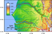
The lowest point in Senegal is the Atlantic Ocean, at sea level
Sea level
Mean sea level is a measure of the average height of the ocean's surface ; used as a standard in reckoning land elevation...
. The highest point is an unnamed feature near Nepen Diakha
Nepen Diakha
Nepen Diakha is a locality situated in Tambacounda, Senegal. The highest point of the country is located 2770 meters south-east of Nepen Diakha an unnamed ridge that is customarily stated as 581 metres above sea level, defining the border with Guinea...
in the Fouta Djallon
Fouta Djallon
Fouta Djallon is a highland region in the centre of Guinea, West Africa. The indigenous name is Fuuta-Jaloo...
foothills at 581 m (1,906 ft)).
Climate
Tropical; hot, humid; rainy season (May to November) has strong southeast winds; dry season (December to April) dominated by hot, dry, harmattan wind.Well-defined dry and humid seasons result from northeast winter winds and southwest summer winds. Dakar's annual rainfall of about 600 mm (23.6 in) occurs between June and October when maximum temperatures average 30 °C (86 °F) and minimums 24.2 °C (75.6 °F); December to February maximum temperatures average 25.7 °C (78.3 °F) and minimums 18 °C (64.4 °F). Interior temperatures are higher than along the coast (for example, average daily temperatures in Kaolack and Tambacounda for May are 30 °C (86 °F) and 32.7 °C (90.9 °F) respectively, compared to Dakar's 23.2 °C (73.8 °F) ), and rainfall increases substantially farther south, exceeding 1500 mm (59.1 in) annually in some areas. In the far interior of the country, in the region of Tambacounda, particularly on the border of Mali, temperatures can reach as high as 54 °C (129.2 °F).
Vegetation:
Senegal has a number of vegetation zones: sahel
Sahel
The Sahel is the ecoclimatic and biogeographic zone of transition between the Sahara desert in the North and the Sudanian Savannas in the south.It stretches across the North African continent between the Atlantic Ocean and the Red Sea....
, Sahel-Soudan, Sudan (region)
Soudan
Soudan may refer to:* The French name for Sudan* The French name for French Sudan * Soudan, Minnesota, an unincorporated town near Tower, Minnesota** The Soudan Mine...
, Soudan-Guinea, tropical rainforest
Tropical rainforest
A tropical rainforest is an ecosystem type that occurs roughly within the latitudes 28 degrees north or south of the equator . This ecosystem experiences high average temperatures and a significant amount of rainfall...
, and Guinean mangroves
Guinean mangroves
The Guinean mangroves are a coastal ecoregion of mangrove swamps in rivers and estuaries near the ocean of West Africa from Senegal to Sierra Leone.-Location and description:...
. Most of the southern Casamance
Casamance
Casamance is the area of Senegal south of The Gambia including the Casamance River. It consists of Basse Casamance and Haute Casamance...
arm of the country has been classified by the World Wildlife Fund as part of the Guinean forest-savanna mosaic
Guinean forest-savanna mosaic
The Guinean forest-savanna mosaic is an ecoregion of West Africa, a band of interlaced forest, savanna, and grassland running east to west and dividing the tropical moist forests near the coast from the West Sudanian savanna of the interior.-Setting:...
ecoregion
Ecoregion
An ecoregion , sometimes called a bioregion, is an ecologically and geographically defined area that is smaller than an ecozone and larger than an ecosystem. Ecoregions cover relatively large areas of land or water, and contain characteristic, geographically distinct assemblages of natural...
.
Finally, it's worth looking out these 2 last maps, although they include "other zones" as well.
----
Terrain:
generally low, rolling, plains rising to foothills in the southeast.
Natural resources:
fish
Fish
Fish are a paraphyletic group of organisms that consist of all gill-bearing aquatic vertebrate animals that lack limbs with digits. Included in this definition are the living hagfish, lampreys, and cartilaginous and bony fish, as well as various extinct related groups...
, phosphates, iron ore
Land use:
arable land:
12%
permanent crops:
0%
permanent pastures:
16%
forests and woodland:
54%
other:
18% (1993 est.)
Irrigated land:
1,200 km² (2003 est.)
Natural hazards:
lowlands seasonally flooded; periodic droughts
Environment - current issues:
wildlife populations threatened by poaching; deforestation; overgrazing; soil erosion; desertification; overfishing
Senegal is a party to several environmental treaties:
- Comprehensive Test Ban TreatyComprehensive Test Ban TreatyThe Comprehensive Nuclear-Test-Ban Treaty bans all nuclear explosions in all environments, for military or civilian purposes. It was adopted by the United Nations General Assembly on 10 September 1996 but it has not entered into force.-Status:...
- Convention on Biological DiversityConvention on Biological DiversityThe Convention on Biological Diversity , known informally as the Biodiversity Convention, is an international legally binding treaty...
- Convention on Fishing and Conservation of Living Resources of the High SeasConvention on Fishing and Conservation of Living Resources of the High SeasThe Convention on Fishing and Conservation of Living Resources of the High Seas is an agreement that was designed to solve through international cooperation the problems involved in the conservation of living resources of the high seas, considering that because of the development of modern...
- Convention on the International Trade in Endangered Species of Wild Flora and FaunaConvention on the International Trade in Endangered Species of Wild Flora and FaunaCITES is a multilateral treaty, drafted as a result of a resolution adopted in 1963 at a meeting of members of the International Union for Conservation of Nature...
- International Convention for the Regulation of WhalingInternational Convention for the Regulation of WhalingThe International Convention for the Regulation of Whaling is an international environmental agreement signed in 1946 in order to "provide for the proper conservation of whale stocks and thus make possible the orderly development of the whaling industry"...
- Montreal ProtocolMontreal ProtocolThe Montreal Protocol on Substances That Deplete the Ozone Layer is an international treaty designed to protect the ozone layer by phasing out the production of numerous substances believed to be responsible for ozone depletion...
- United Nations Framework Convention on Climate ChangeUnited Nations Framework Convention on Climate ChangeThe United Nations Framework Convention on Climate Change is an international environmental treaty produced at the United Nations Conference on Environment and Development , informally known as the Earth Summit, held in Rio de Janeiro from June 3 to 14, 1992...
- United Nations Convention to Combat DesertificationUnited Nations Convention to Combat DesertificationThe United Nations Convention to Combat Desertification in Those Countries Experiencing Serious Drought and/or Desertification, Particularly in Africa is a Convention to combat desertification and mitigate the effects of drought through national action programs that incorporate long-term strategies...
- United Nations Convention on the Law of the SeaUnited Nations Convention on the Law of the SeaThe United Nations Convention on the Law of the Sea , also called the Law of the Sea Convention or the Law of the Sea treaty, is the international agreement that resulted from the third United Nations Conference on the Law of the Sea , which took place from 1973 through 1982...
- Ramsar ConventionRamsar ConventionThe Ramsar Convention is an international treaty for the conservation and sustainable utilization of wetlands, i.e., to stem the progressive encroachment on and loss of wetlands now and in the future, recognizing the fundamental ecological functions of wetlands and their economic, cultural,...
- 1978 Convention on Ship Pollution
Senegal has signed, but not ratified the Convention on Marine Dumping.
Extreme points
This is a list of the extreme points of SenegalSenegal
Senegal , officially the Republic of Senegal , is a country in western Africa. It owes its name to the Sénégal River that borders it to the east and north...
, the points that are farther north, south, east or west than any other location.
- Northern-most point – unnamed location on the border with MauritaniaMauritaniaMauritania is a country in the Maghreb and West Africa. It is bordered by the Atlantic Ocean in the west, by Western Sahara in the north, by Algeria in the northeast, by Mali in the east and southeast, and by Senegal in the southwest...
in the Senegal riverSénégal RiverThe Sénégal River is a long river in West Africa that forms the border between Senegal and Mauritania.The Sénégal's headwaters are the Semefé and Bafing rivers which both originate in Guinea; they form a small part of the Guinean-Malian border before coming together at Bafoulabé in Mali...
immediately north-west of the town of PodorPodorPodor is the northernmost town in Senegal, Africa, lying on Morfil Island between the Sénégal River and Doué River. It is home to a ruined French fort, built in 1854 as a centre for gold trading, and is the birthplace of fashion designer Oumou Sy, and musicians Baaba Maal and Mansour Seck....
, Saint-Louis RegionSaint-Louis RegionThe Saint-Louis Region of Senegal is on the border with Mauritania. Its capital is Saint-Louis.Famous for its cast iron bridge, built by French colonialists in the 19th century, it is close to the Djoudj National Bird Sanctuary, home to thousands of birds, some indigenous to the... - Eastern-most point – unnamed location on the border with MaliMaliMali , officially the Republic of Mali , is a landlocked country in Western Africa. Mali borders Algeria on the north, Niger on the east, Burkina Faso and the Côte d'Ivoire on the south, Guinea on the south-west, and Senegal and Mauritania on the west. Its size is just over 1,240,000 km² with...
near the confluenceConfluenceConfluence, in geography, describes the meeting of two or more bodies of water.Confluence may also refer to:* Confluence , a property of term rewriting systems...
of the Balin-Ko river and the Falémé RiverFaleme RiverThe Falémé River is a river in West Africa. The Falémé arises in northern Guinea and flows in a north-northeast direction to Mali, forming a short portion of the border between Guinea and Senegal...
, Kédougou RegionKédougou RegionKédougou Region is a region of Senegal. It was created in 2008. Formerly it was a department in the Region of Tambacounda.Kedougou has a number of ecotourism attractions... - Southern-most point – unnamed location on the border with GuineaGuineaGuinea , officially the Republic of Guinea , is a country in West Africa. Formerly known as French Guinea , it is today sometimes called Guinea-Conakry to distinguish it from its neighbour Guinea-Bissau. Guinea is divided into eight administrative regions and subdivided into thirty-three prefectures...
immediately south of the village of Toile, Kédougou Region - Western-most point - Pointe des AlmadiesPointe des AlmadiesPointe des Almadies is the westernmost point on the continent of Africa. Pointe des Almadies is located on the northwestern end of the Cap Vert peninsula in Senegal.- Environs :...
, Cap Vert peninsula, Dakar RegionDakar RegionDakar région is the smallest and most populated région of Senegal, encompassing the capital city of the country, Dakar, and all its suburbs along the Cap–Vert Peninsula, Africa's most westerly point.-Administration:...
*
- *Note: this is the also the western-most point of the African continent