
Geography of Saudi Arabia
Encyclopedia
Saudi Arabia
is a country situated in Southwest Asia
, the largest country of Arabia, bordering the Persian Gulf
and the Red Sea
, north of Yemen
. Its extensive coastlines on the Persian Gulf and Red Sea provide great leverage on shipping
(especially crude oil) through the Persian Gulf and Suez Canal
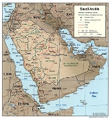
. The kingdom occupies 80% of the Arabian Peninsula. Like Most of the country's boundaries with the United Arab Emirates (UAE), Oman, and the Republic of Yemen (formerly two separate countries: the Yemen Arab Republic, or North Yemen; and the People's Democratic Republic of Yemen, or South Yemen) are undefined, so the exact size of the country remains unknown. The Saudi government estimate is 2,217,949 square kilometers. Other reputable estimates vary between 2,149,690 square kilometers and 2,240,000 square kilometers. Less than 1 % of the total area is suitable for cultivation, and in the early 1990s population distribution varied greatly among the towns of the eastern and western coastal areas, the densely populated interior oases, and the vast, almost empty deserts.
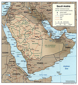
 Saudi Arabia is bounded by seven countries and three bodies of water. To the west, the Gulf of Aqaba and the Red Sea form a coastal border of almost 1,800 kilometers that extends to the southern part of Yemen and follows a mountain ridge for approximately 320 kilometers to the vicinity of Najran. This section of the border with Yemen was demarcated in 1934 and is one of the few clearly defined borders with a neighboring country. The Saudi border running southeast from Najran, however, is still undetermined. The undemarcated border became an issue in the early 1990s, when oil was discovered in the area and Saudi Arabia objected to the commercial exploration by foreign companies on behalf of Yemen. In the summer of 1992, representatives of Saudi Arabia and Yemen met in Geneva to discuss settlement of the border issue.
To the north, Saudi Arabia is bounded by Jordan, Iraq, and Kuwait. The northern boundary extends almost 1,400 kilometers from the Gulf of Aqaba on the west to Ras al Khafji on the Persian Gulf. In 1965 Saudi Arabia and Jordan agreed to boundary demarcations involving an exchange of small areas of territory that gave Jordan some essential additional land near Aqaba, its only port.
In 1922 Abd al Aziz ibn Abd ar Rahman Al Saud (r. 1902–53) and British officials representing Iraqi interests signed the Treaty of Mohammara, which established the boundary between Iraq and the future Saudi Arabia. Later that year, the Al Uqair Convention signed by the two parties agreed to the creation of a diamond-shaped Iraq–Saudi Arabia Neutral Zone of approximately 7,000 square kilometers, adjacent to the western tip of Kuwait, within which neither Iraq nor Saudi Arabia would build permanent dwellings or installations. The agreement was designed to safeguard water rights in the zone for Bedouin of both countries. In May 1938, Iraq and Saudi Arabia signed an additional agreement regarding the administration of the zone. Forty-three years later, Saudi Arabia and Iraq signed an agreement that defined the border between the two countries and provided for the division of the neutral zone between them. The agreement effectively dissolved the neutral zone.
The boundary between Abd al Aziz's territories of Najd and the Eastern Province and the British protectorate of Kuwait was first regulated by the Al Uqair Convention in 1922. In an effort to avoid territorial disputes, another diamond-shaped Divided Zone of 5,790 square kilometers directly south of Kuwait was established. In 1938 oil was discovered in Kuwait's southern Burqan fields, and both countries contracted with foreign oil companies to perform exploration work in the Divided Zone. After years of discussions, Saudi Arabia and Kuwait reached an agreement in 1965 that divided the zone geographically, with each country administering its half of the zone. The agreement guaranteed that the rights of both parties to the natural resources in the whole zone would continue to be respected after each country had annexed its half of the zone in 1966.
Saudi Arabia's eastern boundary follows the Persian Gulf from Ras al Khafji to the peninsula of Qatar, whose border with Saudi Arabia was determined in 1965. The Saudi border with the state of Oman, on the southeastern coast of the Arabian Peninsula, runs through the Empty Quarter (Rub al Khali). The border demarcation was defined by a 1990 agreement between Saudi Arabia and Oman that included provisions for shared grazing rights
and water rights. The border through Al Buraymi Oasis, located near the conjunction of the frontiers of Oman, Abu Dhabi (one of the emirates of the UAE), and Saudi Arabia, has triggered extensive dispute among the three states since the Treaty of Jiddah in 1927. In a 1975 agreement with Saudi Arabia, Abu Dhabi accepted sovereignty over six villages in the Al Buraymi Oasis and the sharing of the rich Zararah oil field. In return, Saudi Arabia obtained an outlet to the Persian Gulf through Abu Dhabi.
Saudi Arabia's maritime claims include a twelve-nautical-mile (22 km) territorial limit along its coasts. The Saudis also claim many small islands as well as some seabeds and subsoils beyond the twelve-nautical-mile (22 km) limit.
Land boundaries:
total:
4,415 km
border countries:
Iraq
814 km, Jordan
728 km, Kuwait
222 km, Oman
676 km, Qatar
60 km, UAE
457 km, Yemen 1,458 km
Coastline:
2,640 km
Maritime claims:
contiguous zone:
18 nmi (33.3 km; 20.7 mi)
continental shelf:
not specified
territorial sea:
12 nmi (22.2 km; 13.8 mi)
had lakes at Layla Aflaj and deep waterholes at Al-Kharj, fed by huge underground aquifers, formed in prehistoric times and non-renewable. Al Kharj was a valuable source of drinking water in a barren terrain. In recent years, these aquifer have been drawn upon heavily, both for agricultural
and domestic purposes, and no fresh water remain in the lakes or pits.
In the absence of permanent rivers or bodies of water, rainfall, groundwater, desalinated seawater, and very scarce surface water must supply the country's needs. In eastern Arabia and in the Jabal Tuwayq, artesian
wells and springs are plentiful. In Al Ahsa a number of large, deep pools are constantly replenished by artesian springs as a result of underground water from the eastern watershed of the Jabal Tuwayq. Such springs and wells permit extensive irrigation in local oases. In the Hijaz and Asir, wells are abundant, and springs are common in the mountainous areas. In Najd
and the great deserts, watering places are comparatively fewer and scattered over a wide area. Water must be hoisted or pumped to the surface, and even where water is plentiful, its quality may be poor.
Modern technology has located and increased the availability of much of the underground water. Saudi Arabian Oil Company (Saudi Aramco) technicians have determined that very deep aquifer
s lie in many areas of northern and eastern Arabia and that the Wasia, the largest aquifer in Saudi Arabia, contains more water than the Persian Gulf. The Saudi government, Saudi Aramco, and the United Nations (UN) Food and Agriculture Organization (FAO) have made separate and joint efforts to exploit underground water resources. In the past, improperly drilled wells have reduced or destroyed any good they might have served by leaching the lands they were drilled to irrigate. Successive agricultural projects, many of which were designed primarily to encourage Bedouin settlement, have increased water resource exploitation. In the early 1990s, large-scale agricultural projects have relied primarily on such underground aquifers, which provided more than 80 % of the water for agricultural requirements. In fiscal year (FY) 1987, about 90% of the total water demand in the kingdom was consumed by agriculture.
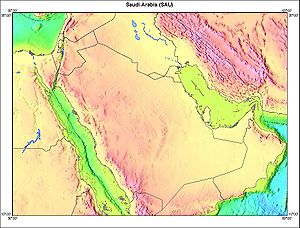
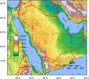
 The Arabian Peninsula
is an ancient massif composed of stable crystalline rock whose geologic structure developed concurrently with the Alps
. Geologic movements caused the entire mass to tilt eastward and the western and southern edges to tilt upward. In the valley created by the fault, called the Great Rift
, the Red Sea was formed. The Great Rift runs from the Mediterranean along both sides of the Red Sea south through Ethiopia
and the lake country of East Africa
, gradually disappearing in the area of Mozambique
, Zambia
, and Zimbabwe
. Scientists analyzing photographs taken by United States astronauts on the joint United States-Soviet space mission in July 1975 detected a vast fan-shaped complex of cracks and fault lines extending north and east from the Golan Heights. These fault lines are believed to be the northern and final portion of the Great Rift and are presumed to be the result of the slow rotation of the Arabian Peninsula counterclockwise in a way that will, in approximately 10 million years, close off the Persian Gulf
and make it a lake.
On the peninsula, the eastern line of the Great Rift fault is visible in the steep and, in places, high escarpment that parallels the Red Sea
between the Gulf of Aqaba
and the Gulf of Aden
. The eastern slope of this escarpment is relatively gentle, dropping to the exposed shield of the ancient landmass that existed before the faulting occurred. A second lower escarpment, the Jabal Tuwayq, runs north to south through the area of Riyadh
.
The northern half of the region of the Red Sea escarpment is known as the Hijaz and the more rugged southern half as Asir. In the south, a coastal plain, the Tihamah
, rises gradually from the sea to the mountains. Asir extends southward to the borders of mountainous Yemen
. The central plateau, Najd, extends east to the Jabal Tuwayq and slightly beyond. A long, narrow strip of desert known as Ad Dahna separates Najd from eastern Arabia, which slopes eastward to the sandy coast along the Persian Gulf. North of Najd a larger desert, An Nafud, isolates the heart of the peninsula from the steppes of northern Arabia. South of Najd lies one of the largest sand deserts in the world, the Rub al Khali.
. The northern range in the Hejaz seldom exceeds 2,100 meters, and the elevation gradually decreases toward the south to about 600 meters around Mecca
. The rugged mountain wall drops abruptly to the sea with only a few intermittent coastal plains. There are virtually no natural harbors along the Red Sea. The western slopes have been stripped of soil by the erosion of infrequent but turbulent rainfalls that have fertilized the plains to the west. The eastern slopes are less steep and are marked by dry river beds (wadi
s) that trace the courses of ancient rivers and continue to lead the rare rainfalls down to the plains. Scattered oases, drawing water from springs and wells in the vicinity of the wadis, permit some settled agriculture. Of these oases, the largest and most important is Medina
. South of Mecca, the mountains exceed 2,400 meters in several places with some peaks nearing 3,000 meters.
The rugged western face of the escarpment drops steeply to the coastal plain, the Tihamah
lowlands, whose width averages only sixty-five kilometers. Along the seacoast is a salty tidal plain of limited agricultural value, backed by potentially rich alluvial plains. The relatively well-watered and fertile upper slopes and the mountains behind are extensively terraced to allow maximum land use. This coastal plain is part of the Arabian Peninsula coastal fog desert
ecoregion
.
The eastern slope of the mountain range in Asir is gentle, melding into a plateau region that drops gradually into the Rub al Khali. Although rainfall is infrequent in this area, a number of fertile wadis, of which the most important are the Wadi Bishah and the Wadi Tathlith, make oasis agriculture possible on a relatively large scale. A number of extensive lava fields (harrat) scar the surfaces of the plateaus east of the mountain ranges in the Hijaz and Asir and give evidence of fairly recent volcanic activity. The largest of these beds is Khaybar, north of Medina; another is Al Harrah
, part of the large volcanic field Harrat Ash Shamah
.
. This region is mainly rocky plateau interspersed by small, sandy deserts and isolated mountain clumps. The best known of the mountain groups is the Jabal Shammar, northwest of Riyadh and just south of the An Nafud. This area is the home of the pastoral Shammar
tribes, which under the leadership of the Al Rashid
were the most implacable foes of the Al Saud in the late nineteenth and early twentieth centuries.no Their capital was the large oasis of Hail
, now a flourishing urban center.
Across the peninsula as a whole, the plateau slopes toward the east from an elevation of 1,360 meters in the west to 750 meters at its easternmost limit. A number of wadis cross the region in an eastward direction from the Red Sea escarpment toward the Persian Gulf. There is little pattern to these remains of ancient riverbeds; the most important of them are Wadi Hanifa
, Wadi ar Rummah, Wadi as Surr, and Wadi ad-Dawasir
.
The heart of Nejd is the area of the Jabal Tuwayq, an arc-shaped ridge with a steep west face that rises between 100 and 250 meters above the plateau. Many oases exist in this area, the most important of which are Buraydah, Unayzah, Riyadh
, and Al Kharj
. Outside the oasis areas, Najd is sparsely populated. Large salt marshes (sabkah) are scattered throughout the area.
. It is an upland plateau scored by numerous wadis, most tending northeastward toward Iraq
. This area, known as Badiyat ash Sham, and covered with grass and scrub vegetation, is extensively used for pasture by nomadic and seminomadic herders. The most significant feature of the area is the Wadi as Sirhan, a large basin as much as 300 meters below the surrounding plateau, which is the vestige of an ancient inland sea. For thousands of years, some of the heavily traveled caravan routes between the Mediterranean and the central and southern peninsula have passed through the Wadi as Sirhan. The most important oases in the area are Al Jawf and Sakakah, just north of the An Nafud.
Farther east the terrain changes abruptly to the flat lowlands of the coastal plain. This area, about sixty kilometers wide, is generally featureless and covered with gravel or sand. In the north is the Ad Dibdibah graveled plain and in the south the Al Jafurah sand desert, which reaches the gulf near Dhahran and merges with the Rub al Khali at its southern end. The coast itself is extremely irregular, merging sandy plains, marshes, and salt flats almost imperceptibly with the sea. As a result, the land surface is unstable; in places water rises almost to the surface, and the sea is shallow, with shoals and reefs extending far offshore. Only the construction of long moles at Ras Tanura has opened the Saudi coast on the gulf to seagoing tankers.
Eastern Arabia is sometimes called Al-Hasa
, or Al Ahsa after the great oasis, one of the more fertile areas of the country. Al-Hasa, the largest oasis in the country, actually comprises two neighboring oases, including the town of Al-Hofuf
.
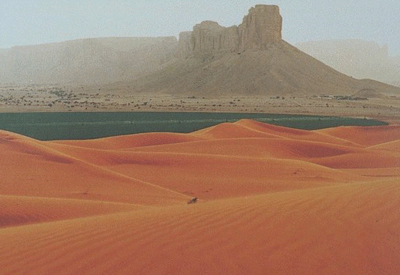
Stretching more than 125 kilometers south from the An Nafud in a narrow arc is the Ad Dahna, a narrow band of sand mountains also called the river of sand. Like the An Nafud, its sand tends to be reddish, particularly in the north, where it shares with the An Nafud the longitudinal structure of sand dunes. The Ad Dahna also furnishes the Bedouin with winter and spring pasture, although water is scarcer than in the An Nafud.
The southern portion of the Ad Dahna curves westward following the arc of the Jabal Tuwayq. At its southern end, it merges with the Rub al Khali, one of the truly forbidding sand deserts in the world and, until the 1950s, one of the least explored. The topography of this huge area, covering more than 550,000 square kilometers, is varied. In the west, the elevation is about 600 meters, and the sand is fine and soft; in the east, the elevation drops to about 180 meters, and much of the surface is covered by relatively stable sand sheets and salt flats. In places, particularly in the east, longitudinal sand dunes prevail; elsewhere sand mountains as much as 300 meters in height form complex patterns. Most of the area is totally waterless and uninhabited except for the few wandering Bedouin
tribes.
lie dark chambers and complex mazes filled Crystalline structures, stalactites and stalagmites. The limestone floor pf the Summan plateau, a karst area to the east of the Dahna sands
, is riddled with such caves, known locally as Dahls. Some have tiny entrances which open into caves, others lead into a maze of passages which can be several kilometers long.
Essential to the formation of these underground cavities is the action of water percolating through the soluble rocks. The process is slow. Rainwater absorbs fractional amounts of Carbon dioxide
from the air as it falls, making a weak carbonic acid solution that eats into the limestone and eventually forms hollows and channels Local bedouin have always know these caves and some were used as water supplies. First systematically studied in the 1981,and currently being explored and reported by the Saudi Geological survey.
The spill had a severe impact on the coastal area surrounding Madinat al Jubayl as Sinaiyah, the major industrial and population center newly planned and built by the Saudi government. The spill threatened industrial facilities in Al Jubayl because of the seawater cooling system for primary industries and threatened the supply of potable water produced by seawater-fed desalination plants. The Al Jubayl community harbor and Abu Ali Island, which juts into the gulf immediately north of Al Jubayl, experienced the greatest pollution, with the main effect of the spill concentrated in mangrove areas and shrimp grounds. Large numbers of marine birds, such as cormorants, grebes, and auks, were killed when their plumage was coated with oil. In addition, beaches along the entire Al Jubayl coastline were covered with oil and tar balls.
The exploding and burning of approximately 700 oil wells in Kuwait also created staggering levels of atmospheric pollution, spewed oily soot into the surrounding areas, and produced lakes of oil in the Kuwaiti desert equal in volume to twenty times the amount of oil that poured into the gulf, or about 150000000 barrels (23,848,094,250 l). The soot from the Kuwaiti fires was found in the snows of the Himalayas and in rainfall over the southern members of the Community of Independent States, Iran, Oman, and Turkey. Residents of Riyadh reported that cars and outdoor furniture were covered daily with a coating of oily soot. The ultimate effects of the airborne pollution from the burning wells have yet to be determined, but samples of soil and vegetation in Ras al Khafji in northern Saudi Arabia revealed high levels of particles of oily soot incorporated into the desert ecology. The UN Environmental Programme warned that eating livestock that grazed within an area of 7,000 square kilometers of the fires, or 1,100 kilometers from the center of the fires, an area that included northern Saudi Arabia, posed a danger to human health. The overall effects of the oil spill and the oil fires on marine life, human health, water quality, and vegetation remained to be determined as of 1992. Moreover, to these two major sources of environmental damage must be added large quantities of refuse, toxic materials, and between 173 million and 207 million liters of untreated sewage in sand pits left behind by coalition forces.
Natural hazards:
frequent sand and dust storms
Environment - current issues:
desertification; depletion of ground water resources; the lack of perennial rivers or permanent water bodies has prompted the development of extensive seawater desalination facilities; coastal pollution from oil spills
Environment - international agreements:
party to:
Climate Change
, Desertification
, Endangered Species
, Hazardous Wastes, Law of the Sea
, Ozone Layer Protection
signed, but not ratified:
none of the selected agreements
2,217,949 km²
land:
2,217,949 km²
water:
0 km²
Elevation extremes:
lowest point:
Persian Gulf 0 m
highest point:
Claimed to be Jabal Sawda
' 3,133 m, but this elevation is disputed by SRTM data (2,985 m), which also questions the high point location
Land use:
arable land:
2%
permanent crops:
0%
permanent pastures:
56%
forests and woodland:
1%
other:
41% (1993 est.)
Irrigated land:
4,350 km² (1993 est.)
Saudi Arabia
The Kingdom of Saudi Arabia , commonly known in British English as Saudi Arabia and in Arabic as as-Sa‘ūdiyyah , is the largest state in Western Asia by land area, constituting the bulk of the Arabian Peninsula, and the second-largest in the Arab World...
is a country situated in Southwest Asia
Southwest Asia
Western Asia, West Asia, Southwest Asia or Southwestern Asia are terms that describe the westernmost portion of Asia. The terms are partly coterminous with the Middle East, which describes a geographical position in relation to Western Europe rather than its location within Asia...
, the largest country of Arabia, bordering the Persian Gulf
Persian Gulf
The Persian Gulf, in Southwest Asia, is an extension of the Indian Ocean located between Iran and the Arabian Peninsula.The Persian Gulf was the focus of the 1980–1988 Iran-Iraq War, in which each side attacked the other's oil tankers...
and the Red Sea
Red Sea
The Red Sea is a seawater inlet of the Indian Ocean, lying between Africa and Asia. The connection to the ocean is in the south through the Bab el Mandeb strait and the Gulf of Aden. In the north, there is the Sinai Peninsula, the Gulf of Aqaba, and the Gulf of Suez...
, north of Yemen
Yemen
The Republic of Yemen , commonly known as Yemen , is a country located in the Middle East, occupying the southwestern to southern end of the Arabian Peninsula. It is bordered by Saudi Arabia to the north, the Red Sea to the west, and Oman to the east....
. Its extensive coastlines on the Persian Gulf and Red Sea provide great leverage on shipping
Shipping
Shipping has multiple meanings. It can be a physical process of transporting commodities and merchandise goods and cargo, by land, air, and sea. It also can describe the movement of objects by ship.Land or "ground" shipping can be by train or by truck...
(especially crude oil) through the Persian Gulf and Suez Canal
Suez Canal
The Suez Canal , also known by the nickname "The Highway to India", is an artificial sea-level waterway in Egypt, connecting the Mediterranean Sea and the Red Sea. Opened in November 1869 after 10 years of construction work, it allows water transportation between Europe and Asia without navigation...
. The kingdom occupies 80% of the Arabian Peninsula. Like Most of the country's boundaries with the United Arab Emirates (UAE), Oman, and the Republic of Yemen (formerly two separate countries: the Yemen Arab Republic, or North Yemen; and the People's Democratic Republic of Yemen, or South Yemen) are undefined, so the exact size of the country remains unknown. The Saudi government estimate is 2,217,949 square kilometers. Other reputable estimates vary between 2,149,690 square kilometers and 2,240,000 square kilometers. Less than 1 % of the total area is suitable for cultivation, and in the early 1990s population distribution varied greatly among the towns of the eastern and western coastal areas, the densely populated interior oases, and the vast, almost empty deserts.
External boundaries
To the north, Saudi Arabia is bounded by Jordan, Iraq, and Kuwait. The northern boundary extends almost 1,400 kilometers from the Gulf of Aqaba on the west to Ras al Khafji on the Persian Gulf. In 1965 Saudi Arabia and Jordan agreed to boundary demarcations involving an exchange of small areas of territory that gave Jordan some essential additional land near Aqaba, its only port.
In 1922 Abd al Aziz ibn Abd ar Rahman Al Saud (r. 1902–53) and British officials representing Iraqi interests signed the Treaty of Mohammara, which established the boundary between Iraq and the future Saudi Arabia. Later that year, the Al Uqair Convention signed by the two parties agreed to the creation of a diamond-shaped Iraq–Saudi Arabia Neutral Zone of approximately 7,000 square kilometers, adjacent to the western tip of Kuwait, within which neither Iraq nor Saudi Arabia would build permanent dwellings or installations. The agreement was designed to safeguard water rights in the zone for Bedouin of both countries. In May 1938, Iraq and Saudi Arabia signed an additional agreement regarding the administration of the zone. Forty-three years later, Saudi Arabia and Iraq signed an agreement that defined the border between the two countries and provided for the division of the neutral zone between them. The agreement effectively dissolved the neutral zone.
The boundary between Abd al Aziz's territories of Najd and the Eastern Province and the British protectorate of Kuwait was first regulated by the Al Uqair Convention in 1922. In an effort to avoid territorial disputes, another diamond-shaped Divided Zone of 5,790 square kilometers directly south of Kuwait was established. In 1938 oil was discovered in Kuwait's southern Burqan fields, and both countries contracted with foreign oil companies to perform exploration work in the Divided Zone. After years of discussions, Saudi Arabia and Kuwait reached an agreement in 1965 that divided the zone geographically, with each country administering its half of the zone. The agreement guaranteed that the rights of both parties to the natural resources in the whole zone would continue to be respected after each country had annexed its half of the zone in 1966.
Saudi Arabia's eastern boundary follows the Persian Gulf from Ras al Khafji to the peninsula of Qatar, whose border with Saudi Arabia was determined in 1965. The Saudi border with the state of Oman, on the southeastern coast of the Arabian Peninsula, runs through the Empty Quarter (Rub al Khali). The border demarcation was defined by a 1990 agreement between Saudi Arabia and Oman that included provisions for shared grazing rights
Grazing rights
Grazing rights is a legal term referring to the right of a user to allow their livestock to feed in a given area.- United States :...
and water rights. The border through Al Buraymi Oasis, located near the conjunction of the frontiers of Oman, Abu Dhabi (one of the emirates of the UAE), and Saudi Arabia, has triggered extensive dispute among the three states since the Treaty of Jiddah in 1927. In a 1975 agreement with Saudi Arabia, Abu Dhabi accepted sovereignty over six villages in the Al Buraymi Oasis and the sharing of the rich Zararah oil field. In return, Saudi Arabia obtained an outlet to the Persian Gulf through Abu Dhabi.
Saudi Arabia's maritime claims include a twelve-nautical-mile (22 km) territorial limit along its coasts. The Saudis also claim many small islands as well as some seabeds and subsoils beyond the twelve-nautical-mile (22 km) limit.
Land boundaries:
total:
4,415 km
border countries:
Iraq
Iraq
Iraq ; officially the Republic of Iraq is a country in Western Asia spanning most of the northwestern end of the Zagros mountain range, the eastern part of the Syrian Desert and the northern part of the Arabian Desert....
814 km, Jordan
Jordan
Jordan , officially the Hashemite Kingdom of Jordan , Al-Mamlaka al-Urduniyya al-Hashemiyya) is a kingdom on the East Bank of the River Jordan. The country borders Saudi Arabia to the east and south-east, Iraq to the north-east, Syria to the north and the West Bank and Israel to the west, sharing...
728 km, Kuwait
Kuwait
The State of Kuwait is a sovereign Arab state situated in the north-east of the Arabian Peninsula in Western Asia. It is bordered by Saudi Arabia to the south at Khafji, and Iraq to the north at Basra. It lies on the north-western shore of the Persian Gulf. The name Kuwait is derived from the...
222 km, Oman
Oman
Oman , officially called the Sultanate of Oman , is an Arab state in southwest Asia on the southeast coast of the Arabian Peninsula. It is bordered by the United Arab Emirates to the northwest, Saudi Arabia to the west, and Yemen to the southwest. The coast is formed by the Arabian Sea on the...
676 km, Qatar
Qatar
Qatar , also known as the State of Qatar or locally Dawlat Qaṭar, is a sovereign Arab state, located in the Middle East, occupying the small Qatar Peninsula on the northeasterly coast of the much larger Arabian Peninsula. Its sole land border is with Saudi Arabia to the south, with the rest of its...
60 km, UAE
United Arab Emirates
The United Arab Emirates, abbreviated as the UAE, or shortened to "the Emirates", is a state situated in the southeast of the Arabian Peninsula in Western Asia on the Persian Gulf, bordering Oman, and Saudi Arabia, and sharing sea borders with Iraq, Kuwait, Bahrain, Qatar, and Iran.The UAE is a...
457 km, Yemen 1,458 km
Coastline:
2,640 km
Maritime claims:
contiguous zone:
18 nmi (33.3 km; 20.7 mi)
continental shelf:
not specified
territorial sea:
12 nmi (22.2 km; 13.8 mi)
Water resources
Until the 1980s, Saudi ArabiaSaudi Arabia
The Kingdom of Saudi Arabia , commonly known in British English as Saudi Arabia and in Arabic as as-Sa‘ūdiyyah , is the largest state in Western Asia by land area, constituting the bulk of the Arabian Peninsula, and the second-largest in the Arab World...
had lakes at Layla Aflaj and deep waterholes at Al-Kharj, fed by huge underground aquifers, formed in prehistoric times and non-renewable. Al Kharj was a valuable source of drinking water in a barren terrain. In recent years, these aquifer have been drawn upon heavily, both for agricultural
Agriculture
Agriculture is the cultivation of animals, plants, fungi and other life forms for food, fiber, and other products used to sustain life. Agriculture was the key implement in the rise of sedentary human civilization, whereby farming of domesticated species created food surpluses that nurtured the...
and domestic purposes, and no fresh water remain in the lakes or pits.
In the absence of permanent rivers or bodies of water, rainfall, groundwater, desalinated seawater, and very scarce surface water must supply the country's needs. In eastern Arabia and in the Jabal Tuwayq, artesian
Artesian aquifer
An artesian aquifer is a confined aquifer containing groundwater under positive pressure. This causes the water level in a well to rise to a point where hydrostatic equilibrium has been reached. This type of well is called an artesian well...
wells and springs are plentiful. In Al Ahsa a number of large, deep pools are constantly replenished by artesian springs as a result of underground water from the eastern watershed of the Jabal Tuwayq. Such springs and wells permit extensive irrigation in local oases. In the Hijaz and Asir, wells are abundant, and springs are common in the mountainous areas. In Najd
Najd
Najd or Nejd , literally Highland, is the central region of the Arabian Peninsula.-Boundaries :The Arabic word nejd literally means "upland" and was once applied to a variety of regions within the Arabian Peninsula...
and the great deserts, watering places are comparatively fewer and scattered over a wide area. Water must be hoisted or pumped to the surface, and even where water is plentiful, its quality may be poor.
Modern technology has located and increased the availability of much of the underground water. Saudi Arabian Oil Company (Saudi Aramco) technicians have determined that very deep aquifer
Aquifer
An aquifer is a wet underground layer of water-bearing permeable rock or unconsolidated materials from which groundwater can be usefully extracted using a water well. The study of water flow in aquifers and the characterization of aquifers is called hydrogeology...
s lie in many areas of northern and eastern Arabia and that the Wasia, the largest aquifer in Saudi Arabia, contains more water than the Persian Gulf. The Saudi government, Saudi Aramco, and the United Nations (UN) Food and Agriculture Organization (FAO) have made separate and joint efforts to exploit underground water resources. In the past, improperly drilled wells have reduced or destroyed any good they might have served by leaching the lands they were drilled to irrigate. Successive agricultural projects, many of which were designed primarily to encourage Bedouin settlement, have increased water resource exploitation. In the early 1990s, large-scale agricultural projects have relied primarily on such underground aquifers, which provided more than 80 % of the water for agricultural requirements. In fiscal year (FY) 1987, about 90% of the total water demand in the kingdom was consumed by agriculture.
Topography and natural regions
Arabian Peninsula
The Arabian Peninsula is a land mass situated north-east of Africa. Also known as Arabia or the Arabian subcontinent, it is the world's largest peninsula and covers 3,237,500 km2...
is an ancient massif composed of stable crystalline rock whose geologic structure developed concurrently with the Alps
Alps
The Alps is one of the great mountain range systems of Europe, stretching from Austria and Slovenia in the east through Italy, Switzerland, Liechtenstein and Germany to France in the west....
. Geologic movements caused the entire mass to tilt eastward and the western and southern edges to tilt upward. In the valley created by the fault, called the Great Rift
Great Rift
Great Rift may mean:*Great Rift Valley, a geographical and geological feature, approximately 6,000 km in length, which runs from northern Syria in Southwest Asia to central Mozambique in East Africa...
, the Red Sea was formed. The Great Rift runs from the Mediterranean along both sides of the Red Sea south through Ethiopia
Ethiopia
Ethiopia , officially known as the Federal Democratic Republic of Ethiopia, is a country located in the Horn of Africa. It is the second-most populous nation in Africa, with over 82 million inhabitants, and the tenth-largest by area, occupying 1,100,000 km2...
and the lake country of East Africa
East Africa
East Africa or Eastern Africa is the easterly region of the African continent, variably defined by geography or geopolitics. In the UN scheme of geographic regions, 19 territories constitute Eastern Africa:...
, gradually disappearing in the area of Mozambique
Mozambique
Mozambique, officially the Republic of Mozambique , is a country in southeastern Africa bordered by the Indian Ocean to the east, Tanzania to the north, Malawi and Zambia to the northwest, Zimbabwe to the west and Swaziland and South Africa to the southwest...
, Zambia
Zambia
Zambia , officially the Republic of Zambia, is a landlocked country in Southern Africa. The neighbouring countries are the Democratic Republic of the Congo to the north, Tanzania to the north-east, Malawi to the east, Mozambique, Zimbabwe, Botswana and Namibia to the south, and Angola to the west....
, and Zimbabwe
Zimbabwe
Zimbabwe is a landlocked country located in the southern part of the African continent, between the Zambezi and Limpopo rivers. It is bordered by South Africa to the south, Botswana to the southwest, Zambia and a tip of Namibia to the northwest and Mozambique to the east. Zimbabwe has three...
. Scientists analyzing photographs taken by United States astronauts on the joint United States-Soviet space mission in July 1975 detected a vast fan-shaped complex of cracks and fault lines extending north and east from the Golan Heights. These fault lines are believed to be the northern and final portion of the Great Rift and are presumed to be the result of the slow rotation of the Arabian Peninsula counterclockwise in a way that will, in approximately 10 million years, close off the Persian Gulf
Persian Gulf
The Persian Gulf, in Southwest Asia, is an extension of the Indian Ocean located between Iran and the Arabian Peninsula.The Persian Gulf was the focus of the 1980–1988 Iran-Iraq War, in which each side attacked the other's oil tankers...
and make it a lake.
On the peninsula, the eastern line of the Great Rift fault is visible in the steep and, in places, high escarpment that parallels the Red Sea
Red Sea
The Red Sea is a seawater inlet of the Indian Ocean, lying between Africa and Asia. The connection to the ocean is in the south through the Bab el Mandeb strait and the Gulf of Aden. In the north, there is the Sinai Peninsula, the Gulf of Aqaba, and the Gulf of Suez...
between the Gulf of Aqaba
Gulf of Aqaba
The Gulf of Aqaba is a large gulf located at the northern tip of the Red Sea. In pre twentieth-century and modern sources it is often named the Gulf of Eilat, as Eilat is its predominant Israeli city ....
and the Gulf of Aden
Gulf of Aden
The Gulf of Aden is located in the Arabian Sea between Yemen, on the south coast of the Arabian Peninsula, and Somalia in the Horn of Africa. In the northwest, it connects with the Red Sea through the Bab-el-Mandeb strait, which is about 20 miles wide....
. The eastern slope of this escarpment is relatively gentle, dropping to the exposed shield of the ancient landmass that existed before the faulting occurred. A second lower escarpment, the Jabal Tuwayq, runs north to south through the area of Riyadh
Riyadh
Riyadh is the capital and largest city of Saudi Arabia. It is also the capital of Riyadh Province, and belongs to the historical regions of Najd and Al-Yamama. It is situated in the center of the Arabian Peninsula on a large plateau, and is home to 5,254,560 people, and the urban center of a...
.
The northern half of the region of the Red Sea escarpment is known as the Hijaz and the more rugged southern half as Asir. In the south, a coastal plain, the Tihamah
Tihamah
Tihamah or Tihama is a narrow coastal region of Arabia on the Red Sea. It is currently divided between Saudi Arabia and Yemen. In a broad sense, Tihamah refers to the entire coastline from the Gulf of Aqaba to the Bab el Mandeb Strait but it more often refers only to its southern half, starting...
, rises gradually from the sea to the mountains. Asir extends southward to the borders of mountainous Yemen
Yemen
The Republic of Yemen , commonly known as Yemen , is a country located in the Middle East, occupying the southwestern to southern end of the Arabian Peninsula. It is bordered by Saudi Arabia to the north, the Red Sea to the west, and Oman to the east....
. The central plateau, Najd, extends east to the Jabal Tuwayq and slightly beyond. A long, narrow strip of desert known as Ad Dahna separates Najd from eastern Arabia, which slopes eastward to the sandy coast along the Persian Gulf. North of Najd a larger desert, An Nafud, isolates the heart of the peninsula from the steppes of northern Arabia. South of Najd lies one of the largest sand deserts in the world, the Rub al Khali.
The Hejaz and Asir
The western coastal escarpment can be considered two mountain ranges separated by a gap in the vicinity of MeccaMecca
Mecca is a city in the Hijaz and the capital of Makkah province in Saudi Arabia. The city is located inland from Jeddah in a narrow valley at a height of above sea level...
. The northern range in the Hejaz seldom exceeds 2,100 meters, and the elevation gradually decreases toward the south to about 600 meters around Mecca
Mecca
Mecca is a city in the Hijaz and the capital of Makkah province in Saudi Arabia. The city is located inland from Jeddah in a narrow valley at a height of above sea level...
. The rugged mountain wall drops abruptly to the sea with only a few intermittent coastal plains. There are virtually no natural harbors along the Red Sea. The western slopes have been stripped of soil by the erosion of infrequent but turbulent rainfalls that have fertilized the plains to the west. The eastern slopes are less steep and are marked by dry river beds (wadi
Wadi
Wadi is the Arabic term traditionally referring to a valley. In some cases, it may refer to a dry riverbed that contains water only during times of heavy rain or simply an intermittent stream.-Variant names:...
s) that trace the courses of ancient rivers and continue to lead the rare rainfalls down to the plains. Scattered oases, drawing water from springs and wells in the vicinity of the wadis, permit some settled agriculture. Of these oases, the largest and most important is Medina
Medina
Medina , or ; also transliterated as Madinah, or madinat al-nabi "the city of the prophet") is a city in the Hejaz region of western Saudi Arabia, and serves as the capital of the Al Madinah Province. It is the second holiest city in Islam, and the burial place of the Islamic Prophet Muhammad, and...
. South of Mecca, the mountains exceed 2,400 meters in several places with some peaks nearing 3,000 meters.
The rugged western face of the escarpment drops steeply to the coastal plain, the Tihamah
Tihamah
Tihamah or Tihama is a narrow coastal region of Arabia on the Red Sea. It is currently divided between Saudi Arabia and Yemen. In a broad sense, Tihamah refers to the entire coastline from the Gulf of Aqaba to the Bab el Mandeb Strait but it more often refers only to its southern half, starting...
lowlands, whose width averages only sixty-five kilometers. Along the seacoast is a salty tidal plain of limited agricultural value, backed by potentially rich alluvial plains. The relatively well-watered and fertile upper slopes and the mountains behind are extensively terraced to allow maximum land use. This coastal plain is part of the Arabian Peninsula coastal fog desert
Arabian Peninsula coastal fog desert
The Arabian Peninsula coastal fog desert on the southern coasts of the Arabian peninsula is an ecoregion which experiences thick fogs where visibility may be reduced to 33 feet . It is classed as a Afrotropic fog desert -Location and description:...
ecoregion
Ecoregion
An ecoregion , sometimes called a bioregion, is an ecologically and geographically defined area that is smaller than an ecozone and larger than an ecosystem. Ecoregions cover relatively large areas of land or water, and contain characteristic, geographically distinct assemblages of natural...
.
The eastern slope of the mountain range in Asir is gentle, melding into a plateau region that drops gradually into the Rub al Khali. Although rainfall is infrequent in this area, a number of fertile wadis, of which the most important are the Wadi Bishah and the Wadi Tathlith, make oasis agriculture possible on a relatively large scale. A number of extensive lava fields (harrat) scar the surfaces of the plateaus east of the mountain ranges in the Hijaz and Asir and give evidence of fairly recent volcanic activity. The largest of these beds is Khaybar, north of Medina; another is Al Harrah
Al Harrah
Al Harrah is a large basaltic volcanic field in northwestern Saudi Arabia near the Jordanian border. It covers an area of 15,200 km2. The volcanic field forms the southern third of the massive Harrat Ash Shamah volcanic field, which extends from Syria through Jordan into northern Saudi...
, part of the large volcanic field Harrat Ash Shamah
Harrat Ash Shamah
The Harrat Ash Shamah is a volcanic field covering a total area of some . This massive alkaline volcanic field extends from southern Syria, across Jordan and into northwestern Saudi Arabia....
.
Najd
East of the Hejaz and Asir lies the great plateau area of NajdNajd
Najd or Nejd , literally Highland, is the central region of the Arabian Peninsula.-Boundaries :The Arabic word nejd literally means "upland" and was once applied to a variety of regions within the Arabian Peninsula...
. This region is mainly rocky plateau interspersed by small, sandy deserts and isolated mountain clumps. The best known of the mountain groups is the Jabal Shammar, northwest of Riyadh and just south of the An Nafud. This area is the home of the pastoral Shammar
Shammar
The tribe of Shammar is one of the largest tribes of Nejd-Saudi Arabia, with an estimated 1 million in Iraq, over 2.5 million in Saudi Arabia , a Kuwaiti population of around 100,000, a Syrian population is thought to exceed 1 million and with an unknown number in Jordan...
tribes, which under the leadership of the Al Rashid
Rashidi
Al Rasheed, the House of Rashid, or the House of Rasheed were a historic dynasty of the Arabian Peninsula, and the most formidable enemies of the House of Saud in Nejd...
were the most implacable foes of the Al Saud in the late nineteenth and early twentieth centuries.no Their capital was the large oasis of Hail
Ha'il
Ha'il , also spelled Hail, Ha'yel, or Hayil, is an oasis city in Nejd in northwestern Saudi Arabia. It is the capital of the Ha'il Province. The city has a population of 356,876 according to Ha'il Province....
, now a flourishing urban center.
Across the peninsula as a whole, the plateau slopes toward the east from an elevation of 1,360 meters in the west to 750 meters at its easternmost limit. A number of wadis cross the region in an eastward direction from the Red Sea escarpment toward the Persian Gulf. There is little pattern to these remains of ancient riverbeds; the most important of them are Wadi Hanifa
Wadi Hanifa
Wadi Hanifa is a wadi or valley in the Nejd region in central Saudi Arabia. The valley runs for a length of from north to south, cutting through the city of Riyadh, the capital of Saudi Arabia...
, Wadi ar Rummah, Wadi as Surr, and Wadi ad-Dawasir
Wadi ad-Dawasir
Wadi Al Dawasir is a town in Najd, Saudi Arabia , in the Dawasir valley. The town is the homeland of the tribe of Al-Dawasir, which is the biggest tribe in Saudi Arabia....
.
The heart of Nejd is the area of the Jabal Tuwayq, an arc-shaped ridge with a steep west face that rises between 100 and 250 meters above the plateau. Many oases exist in this area, the most important of which are Buraydah, Unayzah, Riyadh
Riyadh
Riyadh is the capital and largest city of Saudi Arabia. It is also the capital of Riyadh Province, and belongs to the historical regions of Najd and Al-Yamama. It is situated in the center of the Arabian Peninsula on a large plateau, and is home to 5,254,560 people, and the urban center of a...
, and Al Kharj
Al Kharj
Al-Kharj is a city and governorate in central Saudi Arabia. The population of the governorate as a whole was 623,394 according to the 2004 census, 75,716 of whom were non-Saudis. The city is located at around ....
. Outside the oasis areas, Najd is sparsely populated. Large salt marshes (sabkah) are scattered throughout the area.
Northern Arabia
The area north of the An Nafad is geographically part of the Syrian DesertSyrian Desert
The Syrian Desert , also known as the Syro-Arabian desert is a combination of steppe and true desert that is located in the northern Arabian Peninsula covering 200,000 square miles . also the desert is very rocky and flat...
. It is an upland plateau scored by numerous wadis, most tending northeastward toward Iraq
Iraq
Iraq ; officially the Republic of Iraq is a country in Western Asia spanning most of the northwestern end of the Zagros mountain range, the eastern part of the Syrian Desert and the northern part of the Arabian Desert....
. This area, known as Badiyat ash Sham, and covered with grass and scrub vegetation, is extensively used for pasture by nomadic and seminomadic herders. The most significant feature of the area is the Wadi as Sirhan, a large basin as much as 300 meters below the surrounding plateau, which is the vestige of an ancient inland sea. For thousands of years, some of the heavily traveled caravan routes between the Mediterranean and the central and southern peninsula have passed through the Wadi as Sirhan. The most important oases in the area are Al Jawf and Sakakah, just north of the An Nafud.
Eastern Arabia
East of the Ad Dahna lies the As Summen Plateau, about 120 kilometers wide and dropping in elevation from about 400 meters in the west to about 240 meters in the east. The area is generally barren, with a highly eroded surface of ancient river gorges and isolated buttes.Farther east the terrain changes abruptly to the flat lowlands of the coastal plain. This area, about sixty kilometers wide, is generally featureless and covered with gravel or sand. In the north is the Ad Dibdibah graveled plain and in the south the Al Jafurah sand desert, which reaches the gulf near Dhahran and merges with the Rub al Khali at its southern end. The coast itself is extremely irregular, merging sandy plains, marshes, and salt flats almost imperceptibly with the sea. As a result, the land surface is unstable; in places water rises almost to the surface, and the sea is shallow, with shoals and reefs extending far offshore. Only the construction of long moles at Ras Tanura has opened the Saudi coast on the gulf to seagoing tankers.
Eastern Arabia is sometimes called Al-Hasa
Al-Hasa
Al-Ahsa is the largest governorate in Saudi Arabia's Eastern Province, named after Al-Ahsa oasis. The name Al-Ahsa is also given to the biggest city in the region, Hofuf. In classic Arabic, Ahsa means the sound of water underground. It has one of the largest oases in the world with Date Palms of...
, or Al Ahsa after the great oasis, one of the more fertile areas of the country. Al-Hasa, the largest oasis in the country, actually comprises two neighboring oases, including the town of Al-Hofuf
Hofuf
Al-Hofuf is the major urban center in the Al-Ahsa Oasis in the Eastern Province of Saudi Arabia.- Overview :...
.
Great deserts
Three great deserts isolate Najd from north, east, and south as the Red Sea escarpment does from the west. In the north, the An Nafud—sometimes called the Great Nafud because An Nafud is the term for desert—covers about 55,000 square kilometers at an elevation of about 1,000 meters. Longitudinal dunes—scores of kilometers in length and as much as ninety meters high, and separated by valleys as much as sixteen kilometers wide—characterize the An Nafud. Iron oxide gives the sand a red tint, particularly when the sun is low. Within the area are several watering places, and winter rains bring up short-lived but succulent grasses that permit nomadic herding during the winter and spring.Stretching more than 125 kilometers south from the An Nafud in a narrow arc is the Ad Dahna, a narrow band of sand mountains also called the river of sand. Like the An Nafud, its sand tends to be reddish, particularly in the north, where it shares with the An Nafud the longitudinal structure of sand dunes. The Ad Dahna also furnishes the Bedouin with winter and spring pasture, although water is scarcer than in the An Nafud.
The southern portion of the Ad Dahna curves westward following the arc of the Jabal Tuwayq. At its southern end, it merges with the Rub al Khali, one of the truly forbidding sand deserts in the world and, until the 1950s, one of the least explored. The topography of this huge area, covering more than 550,000 square kilometers, is varied. In the west, the elevation is about 600 meters, and the sand is fine and soft; in the east, the elevation drops to about 180 meters, and much of the surface is covered by relatively stable sand sheets and salt flats. In places, particularly in the east, longitudinal sand dunes prevail; elsewhere sand mountains as much as 300 meters in height form complex patterns. Most of the area is totally waterless and uninhabited except for the few wandering Bedouin
Bedouin
The Bedouin are a part of a predominantly desert-dwelling Arab ethnic group traditionally divided into tribes or clans, known in Arabic as ..-Etymology:...
tribes.
Caves
Beneath the harsh deserts of Saudi ArabiaSaudi Arabia
The Kingdom of Saudi Arabia , commonly known in British English as Saudi Arabia and in Arabic as as-Sa‘ūdiyyah , is the largest state in Western Asia by land area, constituting the bulk of the Arabian Peninsula, and the second-largest in the Arab World...
lie dark chambers and complex mazes filled Crystalline structures, stalactites and stalagmites. The limestone floor pf the Summan plateau, a karst area to the east of the Dahna sands
Ad-Dahna Desert
ad-Dahna Desert is the central division of the Arabian Desert. It is a corridor of sandy terrain forming a bow-like shape that connects an-Nafud desert in the north to Rub' al-Khali desert in the south. Its length is more than 1000 km siding Twaik Mountains from the east and does not exceed...
, is riddled with such caves, known locally as Dahls. Some have tiny entrances which open into caves, others lead into a maze of passages which can be several kilometers long.
Essential to the formation of these underground cavities is the action of water percolating through the soluble rocks. The process is slow. Rainwater absorbs fractional amounts of Carbon dioxide
Carbon dioxide
Carbon dioxide is a naturally occurring chemical compound composed of two oxygen atoms covalently bonded to a single carbon atom...
from the air as it falls, making a weak carbonic acid solution that eats into the limestone and eventually forms hollows and channels Local bedouin have always know these caves and some were used as water supplies. First systematically studied in the 1981,and currently being explored and reported by the Saudi Geological survey.
The environment and the Gulf War
The Persian Gulf War of 1991 brought serious environmental damage to the region. The world's largest oil spill, estimated at as much as 8000000 barrels (1,271,898,360 l), fouled gulf waters and the coastal areas of Kuwait, Iran, and much of Saudi Arabia's Persian Gulf shoreline. In some of the sections of the Saudi coast that sustained the worst damage, sediments were found to contain 7 % oil. The shallow areas affected normally provide feeding grounds for birds, and feeding and nursery areas for fish and shrimp. Because the plants and animals of the sea floor are the basis of the food chain, damage to the shoreline has consequences for the whole shallow-water ecosystem, including the multi-million-dollar Saudi fisheries industry.The spill had a severe impact on the coastal area surrounding Madinat al Jubayl as Sinaiyah, the major industrial and population center newly planned and built by the Saudi government. The spill threatened industrial facilities in Al Jubayl because of the seawater cooling system for primary industries and threatened the supply of potable water produced by seawater-fed desalination plants. The Al Jubayl community harbor and Abu Ali Island, which juts into the gulf immediately north of Al Jubayl, experienced the greatest pollution, with the main effect of the spill concentrated in mangrove areas and shrimp grounds. Large numbers of marine birds, such as cormorants, grebes, and auks, were killed when their plumage was coated with oil. In addition, beaches along the entire Al Jubayl coastline were covered with oil and tar balls.
The exploding and burning of approximately 700 oil wells in Kuwait also created staggering levels of atmospheric pollution, spewed oily soot into the surrounding areas, and produced lakes of oil in the Kuwaiti desert equal in volume to twenty times the amount of oil that poured into the gulf, or about 150000000 barrels (23,848,094,250 l). The soot from the Kuwaiti fires was found in the snows of the Himalayas and in rainfall over the southern members of the Community of Independent States, Iran, Oman, and Turkey. Residents of Riyadh reported that cars and outdoor furniture were covered daily with a coating of oily soot. The ultimate effects of the airborne pollution from the burning wells have yet to be determined, but samples of soil and vegetation in Ras al Khafji in northern Saudi Arabia revealed high levels of particles of oily soot incorporated into the desert ecology. The UN Environmental Programme warned that eating livestock that grazed within an area of 7,000 square kilometers of the fires, or 1,100 kilometers from the center of the fires, an area that included northern Saudi Arabia, posed a danger to human health. The overall effects of the oil spill and the oil fires on marine life, human health, water quality, and vegetation remained to be determined as of 1992. Moreover, to these two major sources of environmental damage must be added large quantities of refuse, toxic materials, and between 173 million and 207 million liters of untreated sewage in sand pits left behind by coalition forces.
Natural hazards:
frequent sand and dust storms
Environment - current issues:
desertification; depletion of ground water resources; the lack of perennial rivers or permanent water bodies has prompted the development of extensive seawater desalination facilities; coastal pollution from oil spills
Environment - international agreements:
party to:
Climate Change
United Nations Framework Convention on Climate Change
The United Nations Framework Convention on Climate Change is an international environmental treaty produced at the United Nations Conference on Environment and Development , informally known as the Earth Summit, held in Rio de Janeiro from June 3 to 14, 1992...
, Desertification
Desertification
Desertification is the degradation of land in drylands. Caused by a variety of factors, such as climate change and human activities, desertification is one of the most significant global environmental problems.-Definitions:...
, Endangered Species
Endangered species
An endangered species is a population of organisms which is at risk of becoming extinct because it is either few in numbers, or threatened by changing environmental or predation parameters...
, Hazardous Wastes, Law of the Sea
Law of the sea
Law of the sea may refer to:* United Nations Convention on the Law of the Sea* Admiralty law* The Custom of the Sea...
, Ozone Layer Protection
signed, but not ratified:
none of the selected agreements
Statistics
Area:2,217,949 km²
land:
2,217,949 km²
water:
0 km²
Elevation extremes:
lowest point:
Persian Gulf 0 m
highest point:
Claimed to be Jabal Sawda
Jabal Sawda
Jabal Sawda is a peak located in Saudi Arabia, with an altitude of around 3,000 metres .Most authorities claim that the peak, with a questioned altitude of 3,133 m, is the highest point in Saudi Arabia, but SRTM data indicates an elevation of 2,985m, with higher elevations elsewhere in the...
' 3,133 m, but this elevation is disputed by SRTM data (2,985 m), which also questions the high point location
Land use:
arable land:
2%
permanent crops:
0%
permanent pastures:
56%
forests and woodland:
1%
other:
41% (1993 est.)
Irrigated land:
4,350 km² (1993 est.)
See also
- Unification of Saudi ArabiaUnification of Saudi ArabiaThe unification of Saudi Arabia was the process by which the various tribes, sheikhdoms, and emirates of most of the Arabian Peninsula were consolidated under the control of the House of Saud, or Al Saud, between 1902 and 1932, when the modern-day Kingdom of Saudi Arabia was proclaimed...
- Saudi Arabia – United Arab Emirates border disputeSaudi Arabia – United Arab Emirates border disputeSaudi Arabia has had a number of border disputes with its neighbouring states in the Arabian peninsula.-General Aspects:The border dispute with the United Arab Emirates was apparently resolved with the Treaty of Jeddah which was signed at Jeddah, Saudi Arabia, on 21 August...
- Saudi–Kuwaiti neutral zone
- Saudi–Iraqi neutral zone
- Sykes–Picot Agreement
- Winston's HiccupWinston's HiccupWinston's Hiccup or Churchill's Sneeze is the huge zigzag in Jordan's eastern border with Saudi Arabia, supposedly because Winston Churchill drew the boundary of Transjordan after a generous and lengthy lunch.-In modern times:...
Further reading
- SAUDI ARABIA - The Geology
- Andrew Thompson, Origins of Arabia, 2000, ISBN 1 900988 04 6
- Geological Charts at Arabian Plate Sequence Stratigraphy, 2004.