
Geography of Saint Kitts and Nevis
Encyclopedia
Saint Kitts and Nevis
The Federation of Saint Kitts and Nevis , located in the Leeward Islands, is a federal two-island nation in the West Indies. It is the smallest sovereign state in the Americas, in both area and population....
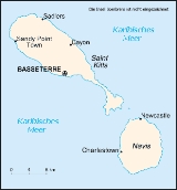
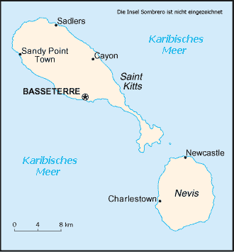
is a twin island country with a total landmass of just 104 square miles (269.4 km²). The island of St. Kitts, the larger of the two, is 68 square miles (176.1 km²) in size and is located at latitude 17.30 N, and longitude 62.80 W. Nevis is 36 square miles (93.2 km²) and located at latitude 17.10 N, longitude 62.35 W, approximately 3 km south-east of St. Kitts. They are about one-third of the way from Puerto Rico
Puerto Rico
Puerto Rico , officially the Commonwealth of Puerto Rico , is an unincorporated territory of the United States, located in the northeastern Caribbean, east of the Dominican Republic and west of both the United States Virgin Islands and the British Virgin Islands.Puerto Rico comprises an...
to Trinidad and Tobago
Trinidad and Tobago
Trinidad and Tobago officially the Republic of Trinidad and Tobago is an archipelagic state in the southern Caribbean, lying just off the coast of northeastern Venezuela and south of Grenada in the Lesser Antilles...
.
Climate
The climateClimate
Climate encompasses the statistics of temperature, humidity, atmospheric pressure, wind, rainfall, atmospheric particle count and other meteorological elemental measurements in a given region over long periods...
of St. Kitts and Nevis is classified as tropical marine with a wet and a dry season. Generally, steady northeast trade winds and tropical oceanic cyclonic movements influence it. Furthermore, the islands enjoy warm even temperatures with a mean of approximately 24–27 °C (75.2–80.6 F) and the humidity
Humidity
Humidity is a term for the amount of water vapor in the air, and can refer to any one of several measurements of humidity. Formally, humid air is not "moist air" but a mixture of water vapor and other constituents of air, and humidity is defined in terms of the water content of this mixture,...
is low at 71%. Seasonal and diurnal variations in temperature are small. Rainfall is mainly orographic and increases in amount and frequency with the altitude. Except for the Southeast Peninsula which is very dry, mean annual rainfall ranges from about 16 inches (406 mm) in the coastal areas, to about 60 inches (1,524 mm) in the central mountain ranges but, from May to October rainfall is heavier while temperatures are a little hotter.
Although the hurricane season officially lasts from June to November, most hurricanes hit during August-November. The 1998 & 1999 Atlantic hurricane season produced 3 hurricanes which battered St.Kitts & Nevis.
Hurricane Georges
Hurricane Georges
Hurricane Georges was a very destructive, powerful and long-lived Cape Verde-type Category 4 hurricane. Georges was the seventh tropical storm, fourth hurricane, and second major hurricane of the 1998 Atlantic hurricane season...
in 1998 produced strong winds of up to 115 mi/h while passing over St.Kitts, downing power lines, telephone lines, and trees across the island. Lack of electricity resulted in damage to water facilities, as well. Georges's high winds caused extensive property damage, damaging 80-85% of the houses on the island, and destroying 20-25% of homes. Many schools, businesses, hospitals, and government buildings lost their roofs, while the airport experienced severe damage to its main terminal and control tower, limiting flights to the daytime. St. Kitts' economy was disrupted from severe agricultural losses, including the devastation of 50% of their sugar crop. In addition, damaged hotels and piers created a long-term impact through lack of tourism - an industry the island relies on. In all, Hurricane Georges caused 5 fatalities, left 3,000 homeless, and resulted in $445 million (1998 USD) in damage on the island. Nevis fared better. Like on St. Kitts, high winds downed power and telephone lines, damaging the water system there. 35% of homes on the island were damaged, though none were destroyed. Rainfall and debris killed several hundred livestock and seriously damaged coconut trees, amounting to $2.5 million (1998 USD) in agricultural damage. There were no casualties reported on the island, and damaged amounted to $39 million (1998 USD).
Hurricane Jose
Hurricane Jose
The name Jose has been used for four tropical cyclones in the Atlantic Ocean.* 1981's Tropical Storm Jose - short-lived and weak storm that did not impact land....
in 1999 cause minor damage because the hurricane passed northward and flooding was the principal hazard as several main roads were washed out and landslides were reported. Rainfall were 12 to 15 in (304.8 to 381 mm).
Also in 1999, Hurricane Lenny
Hurricane Lenny
Hurricane Lenny was the strongest November Atlantic hurricane on record. It was the twelfth tropical storm, eighth hurricane, and record-breaking fifth Category 4 hurricane in the 1999 Atlantic hurricane season. Lenny formed on November 13 in the western Caribbean Sea, and maintained an...
became the strongest Atlantic hurricane ever recorded in the month of November. Hurricane Lenny's storm track was unique in the recorded history of hurricanes. It started life tracking across the Atlantic as a tropical depression and tropical storm in the normal direction (east to west). Then it stalled, changed direction completely, became hurricane-strength and progressing west-to-east through the Caribbean Sea. This triggered storm surge, strong winds, and 12 feet (3.7 m) waves on the more vulnerable western coasts of St. Kitts and Nevis, causing significant beach erosion and flooding. Lenny dumped 20–25 in (508–635 mm) of rain.
Geology
The island of St. Kitts is composed almost exclusively of volcanic rocks of andesiteAndesite
Andesite is an extrusive igneous, volcanic rock, of intermediate composition, with aphanitic to porphyritic texture. In a general sense, it is the intermediate type between basalt and dacite. The mineral assemblage is typically dominated by plagioclase plus pyroxene and/or hornblende. Magnetite,...
or dacite
Dacite
Dacite is an igneous, volcanic rock. It has an aphanitic to porphyritic texture and is intermediate in composition between andesite and rhyolite. The relative proportions of feldspars and quartz in dacite, and in many other volcanic rocks, are illustrated in the QAPF diagram...
mineralogy
Mineralogy
Mineralogy is the study of chemistry, crystal structure, and physical properties of minerals. Specific studies within mineralogy include the processes of mineral origin and formation, classification of minerals, their geographical distribution, as well as their utilization.-History:Early writing...
. Its geology
Geology
Geology is the science comprising the study of solid Earth, the rocks of which it is composed, and the processes by which it evolves. Geology gives insight into the history of the Earth, as it provides the primary evidence for plate tectonics, the evolutionary history of life, and past climates...
is similar to that of other volcanic islands in the Lesser Antillean Archipelago
Antilles
The Antilles islands form the greater part of the West Indies in the Caribbean Sea. The Antilles are divided into two major groups: the "Greater Antilles" to the north and west, including the larger islands of Cuba, Jamaica, Hispaniola , and Puerto Rico; and the smaller "Lesser Antilles" on the...
. The islands are the summits of a submerged mountain range which forms the eastern boundary of what is known as the Caribbean Tectonic Plate
Caribbean Plate
The Caribbean Plate is a mostly oceanic tectonic plate underlying Central America and the Caribbean Sea off the north coast of South America....
. St. Kitts is oriented northwest-southeast, about 80 km long and 16 km wide. The entire island archipelago is geologically young, having begun to form probably less than 50 million years ago, during the Miocene era. Volcanic activity occurred along the ridge
Ridge
A ridge is a geological feature consisting of a chain of mountains or hills that form a continuous elevated crest for some distance. Ridges are usually termed hills or mountains as well, depending on size. There are several main types of ridges:...
s of this arc during the Miocene era and has continued since.
Nevis is a volcanic island that began its formation in mid-Pliocene
Pliocene
The Pliocene Epoch is the period in the geologic timescale that extends from 5.332 million to 2.588 million years before present. It is the second and youngest epoch of the Neogene Period in the Cenozoic Era. The Pliocene follows the Miocene Epoch and is followed by the Pleistocene Epoch...
times (approximately 3.45 million years ago). However, the island comprises a number of discrete eruptive centers that range in age from mid-Pliocene to Pleistocene
Pleistocene
The Pleistocene is the epoch from 2,588,000 to 11,700 years BP that spans the world's recent period of repeated glaciations. The name pleistocene is derived from the Greek and ....
, these prevent any single model of the island's geological evolution. The geology of Nevis can be subdivided into four informal units: Volcanic of the eruptive centers, volcanigenic rocks - pyroclastics and lahar
Lahar
A lahar is a type of mudflow or debris flow composed of a slurry of pyroclastic material, rocky debris, and water. The material flows down from a volcano, typically along a river valley. The term is a shortened version of "berlahar" which originated in the Javanese language of...
s, fluviatile and lacustrine
Lake
A lake is a body of relatively still fresh or salt water of considerable size, localized in a basin, that is surrounded by land. Lakes are inland and not part of the ocean and therefore are distinct from lagoons, and are larger and deeper than ponds. Lakes can be contrasted with rivers or streams,...
deposits, and raised beach
Raised beach
A raised beach, marine terrace, or perched coastline is an emergent coastal landform. Raised beaches and marine terraces are beaches or wave-cut platforms raised above the shore line by a relative fall in the sea level ....
es.
At a Glance
Location:Caribbean
Caribbean
The Caribbean is a crescent-shaped group of islands more than 2,000 miles long separating the Gulf of Mexico and the Caribbean Sea, to the west and south, from the Atlantic Ocean, to the east and north...
, islands in the Caribbean Sea
Caribbean Sea
The Caribbean Sea is a sea of the Atlantic Ocean located in the tropics of the Western hemisphere. It is bounded by Mexico and Central America to the west and southwest, to the north by the Greater Antilles, and to the east by the Lesser Antilles....
, about one-third of the way from Puerto Rico
Puerto Rico
Puerto Rico , officially the Commonwealth of Puerto Rico , is an unincorporated territory of the United States, located in the northeastern Caribbean, east of the Dominican Republic and west of both the United States Virgin Islands and the British Virgin Islands.Puerto Rico comprises an...
to Trinidad and Tobago
Trinidad and Tobago
Trinidad and Tobago officially the Republic of Trinidad and Tobago is an archipelagic state in the southern Caribbean, lying just off the coast of northeastern Venezuela and south of Grenada in the Lesser Antilles...
Geographic coordinates: 17°20′N 62°45′W
Map references:
Central America
Central America
Central America is the central geographic region of the Americas. It is the southernmost, isthmian portion of the North American continent, which connects with South America on the southeast. When considered part of the unified continental model, it is considered a subcontinent...
and the Caribbean
Area:
total:
261 km² (Saint Kitts 168 km²; Nevis 93 km²)
land:
261 km²
water:
0 km²
Area - comparative:
2/3 the size the island of Barbados
Barbados
Barbados is an island country in the Lesser Antilles. It is in length and as much as in width, amounting to . It is situated in the western area of the North Atlantic and 100 kilometres east of the Windward Islands and the Caribbean Sea; therein, it is about east of the islands of Saint...
Land boundaries:
0 km
Coastline:
135 km
Maritime claims:
continental shelf:
200 nautical miles (370 km) or to the edge of the continental margin
territorial sea:
12 nautical miles (22 km)
contiguous zone:
24 nautical miles (44 km)
exclusive economic zone:
200 nautical miles (370 km)
Climate:
tropical tempered by constant sea breezes; little seasonal temperature variation; rainy season (May to November)
Terrain:
volcanic with mountainous interiors
Elevation extremes:
lowest point:
Caribbean Sea 0 m
highest point:
Mount Liamuiga
Mount Liamuiga
Mount Liamuiga is a stratovolcano which forms the western part of the island of Saint Kitts. The peak is the highest point on the island of Saint Kitts, in the federation of Saint Kitts and Nevis, and in the entire British Leeward Islands, as well as one of the tallest peaks in the eastern...
1,156 m
Natural resources:
arable land
Land use:
arable land:
19.44%
permanent crops:
2.78%
other:
77.78% (2005)
Irrigated land:
NA km²
Natural hazards:
hurricanes (July to October)
Environment - current issues:
NA
Environment - international agreements:
party to:
Biodiversity
Biodiversity
Biodiversity is the degree of variation of life forms within a given ecosystem, biome, or an entire planet. Biodiversity is a measure of the health of ecosystems. Biodiversity is in part a function of climate. In terrestrial habitats, tropical regions are typically rich whereas polar regions...
, Climate Change
United Nations Framework Convention on Climate Change
The United Nations Framework Convention on Climate Change is an international environmental treaty produced at the United Nations Conference on Environment and Development , informally known as the Earth Summit, held in Rio de Janeiro from June 3 to 14, 1992...
, Desertification
Desertification
Desertification is the degradation of land in drylands. Caused by a variety of factors, such as climate change and human activities, desertification is one of the most significant global environmental problems.-Definitions:...
, Endangered Species
Endangered species
An endangered species is a population of organisms which is at risk of becoming extinct because it is either few in numbers, or threatened by changing environmental or predation parameters...
, Hazardous Wastes, Law of the Sea
Law of the sea
Law of the sea may refer to:* United Nations Convention on the Law of the Sea* Admiralty law* The Custom of the Sea...
, Ozone Layer Protection, Ship Pollution, Whaling
Whaling
Whaling is the hunting of whales mainly for meat and oil. Its earliest forms date to at least 3000 BC. Various coastal communities have long histories of sustenance whaling and harvesting beached whales...
signed, but not ratified:
none of the selected agreements
See also
- Saint Kitts and NevisSaint Kitts and NevisThe Federation of Saint Kitts and Nevis , located in the Leeward Islands, is a federal two-island nation in the West Indies. It is the smallest sovereign state in the Americas, in both area and population....