

Geography of Saint Helena
Encyclopedia
Saint Helena is an island in the South Atlantic Ocean, about mid-way between South America
and Africa
, at the geographic coordinates 15°56′S 5°42′W. St Helena has a land area of 122 square kilometres and is part of a wider territory called Saint Helena, Ascension and Tristan da Cunha
which includes Ascension Island
and the island group of Tristan da Cunha
.
 The climate of Saint Helena
island can be described as tropical, marine and mild, tempered by the Benguela Current
and trade winds which blow almost continuously. Similarly, the climate of Tristan da Cunha
is marine, mild and also tempered by trade winds, although the climate is temperate in nature. Ascension Island is warmer and wetter than St Helena.
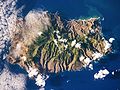
 Saint Helena
has a rugged, volcanic terrain, with small scattered plateau
s and plain
s, with the largest area of level ground on the island being Prosperous Bay Plain
in the eastern arid area. The other islands of the group have a volcanic origin. The highest point on the island is Diana's Peak
at 818 metres (2,684 ft), though Queen Mary's Peak
on Tristan da Cunha
is the highest in the British territory at 2,062 m.
A natural hazard on Tristan da Cunha is active volcanism, though this is not the case on St Helena itself.
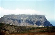
 The Barn is a capping of younger lavas upon weaker rocks. The Barn features cliffs on the side that faces the sea. It overlooks the pyroclasts and weak flows of Turk's Cap Valley to the south.http://www.btinternet.com/~sa_sa/st_helena/st_helena_geology.html
Taking their names from the story of Lot
in the Book of Genesis, "Lot" and "Lot's Wife" are two solitary pillars of rock topping two valleys near Sandy Bay. The pillars are phonolitic intrusions, which are more resistant to erosion than surrounding volcanic features which have, in time, eroded away. http://www.btinternet.com/~sa_sa/st_helena/st_helena_geology.html
as a main natural resource. Land use in the island group is divided between arable land
(with 12.9% of the area given to this) and other uses, which occupy the remaining 87.1%.
In terms of maritime claims, St Helena has an exclusive fishing zone of 200 nautical miles, and a territorial sea of twelve nautical miles.
s and sooty tern
s.
South America
South America is a continent situated in the Western Hemisphere, mostly in the Southern Hemisphere, with a relatively small portion in the Northern Hemisphere. The continent is also considered a subcontinent of the Americas. It is bordered on the west by the Pacific Ocean and on the north and east...
and Africa
Africa
Africa is the world's second largest and second most populous continent, after Asia. At about 30.2 million km² including adjacent islands, it covers 6% of the Earth's total surface area and 20.4% of the total land area...
, at the geographic coordinates 15°56′S 5°42′W. St Helena has a land area of 122 square kilometres and is part of a wider territory called Saint Helena, Ascension and Tristan da Cunha
Saint Helena, Ascension and Tristan da Cunha
Saint Helena, Ascension and Tristan da Cunha is a British overseas territory and overseas territory of the European Union consisting of the islands of Saint Helena, Ascension Island and the Tristan da Cunha group...
which includes Ascension Island
Ascension Island
Ascension Island is an isolated volcanic island in the equatorial waters of the South Atlantic Ocean, around from the coast of Africa and from the coast of South America, which is roughly midway between the horn of South America and Africa...
and the island group of Tristan da Cunha
Tristan da Cunha
Tristan da Cunha is a remote volcanic group of islands in the south Atlantic Ocean and the main island of that group. It is the most remote inhabited archipelago in the world, lying from the nearest land, South Africa, and from South America...
.
Climate
Saint Helena
Saint Helena , named after St Helena of Constantinople, is an island of volcanic origin in the South Atlantic Ocean. It is part of the British overseas territory of Saint Helena, Ascension and Tristan da Cunha which also includes Ascension Island and the islands of Tristan da Cunha...
island can be described as tropical, marine and mild, tempered by the Benguela Current
Benguela Current
The Benguela Current is the broad, northward flowing ocean current that forms the eastern portion of the South Atlantic Ocean gyre. The current extends from roughly Cape Point in the south, to the position of the Angola-Benguela Front in the north, at around 16°S. The current is driven by the...
and trade winds which blow almost continuously. Similarly, the climate of Tristan da Cunha
Tristan da Cunha
Tristan da Cunha is a remote volcanic group of islands in the south Atlantic Ocean and the main island of that group. It is the most remote inhabited archipelago in the world, lying from the nearest land, South Africa, and from South America...
is marine, mild and also tempered by trade winds, although the climate is temperate in nature. Ascension Island is warmer and wetter than St Helena.
Terrain
Saint Helena
Saint Helena , named after St Helena of Constantinople, is an island of volcanic origin in the South Atlantic Ocean. It is part of the British overseas territory of Saint Helena, Ascension and Tristan da Cunha which also includes Ascension Island and the islands of Tristan da Cunha...
has a rugged, volcanic terrain, with small scattered plateau
Plateau
In geology and earth science, a plateau , also called a high plain or tableland, is an area of highland, usually consisting of relatively flat terrain. A highly eroded plateau is called a dissected plateau...
s and plain
Plain
In geography, a plain is land with relatively low relief, that is flat or gently rolling. Prairies and steppes are types of plains, and the archetype for a plain is often thought of as a grassland, but plains in their natural state may also be covered in shrublands, woodland and forest, or...
s, with the largest area of level ground on the island being Prosperous Bay Plain
Prosperous Bay Plain
Prosperous Bay Plain is an area on the north-eastern coast of Saint Helena, a British island territory in the South Atlantic Ocean. It is the site of the proposed Saint Helena Airport and is notable for its high invertebrate biodiversity.-Geography:...
in the eastern arid area. The other islands of the group have a volcanic origin. The highest point on the island is Diana's Peak
Diana's Peak
Diana's Peak is the highest point, at , on the island of Saint Helena, a British overseas territory in the South Atlantic Ocean. It is of volcanic origin. It was proclaimed a national park in March 1996, the first on the island. It is covered in tree fern thicket.The peak is located at the...
at 818 metres (2,684 ft), though Queen Mary's Peak
Queen Mary's Peak
Queen Mary's Peak is the summit of the island of Tristan da Cunha, in the South Atlantic Ocean. It has an elevation of 2,062 metres above sea level. It is named after Mary of Teck, the Queen consort of King George V...
on Tristan da Cunha
Tristan da Cunha
Tristan da Cunha is a remote volcanic group of islands in the south Atlantic Ocean and the main island of that group. It is the most remote inhabited archipelago in the world, lying from the nearest land, South Africa, and from South America...
is the highest in the British territory at 2,062 m.
A natural hazard on Tristan da Cunha is active volcanism, though this is not the case on St Helena itself.
Geological Features
Taking their names from the story of Lot
Lot (Bible)
Lot is a man from the Book of Genesis chapters 11-14 and 19, in the Hebrew Bible. Notable episodes in his life include his travels with his uncle Abram ; his flight from the destruction of Sodom, in the course of which Lot's wife looked back and became a pillar of salt; and the seduction by his...
in the Book of Genesis, "Lot" and "Lot's Wife" are two solitary pillars of rock topping two valleys near Sandy Bay. The pillars are phonolitic intrusions, which are more resistant to erosion than surrounding volcanic features which have, in time, eroded away. http://www.btinternet.com/~sa_sa/st_helena/st_helena_geology.html
Natural resources
Saint Helena possesses fishFish
Fish are a paraphyletic group of organisms that consist of all gill-bearing aquatic vertebrate animals that lack limbs with digits. Included in this definition are the living hagfish, lampreys, and cartilaginous and bony fish, as well as various extinct related groups...
as a main natural resource. Land use in the island group is divided between arable land
Arable land
In geography and agriculture, arable land is land that can be used for growing crops. It includes all land under temporary crops , temporary meadows for mowing or pasture, land under market and kitchen gardens and land temporarily fallow...
(with 12.9% of the area given to this) and other uses, which occupy the remaining 87.1%.
In terms of maritime claims, St Helena has an exclusive fishing zone of 200 nautical miles, and a territorial sea of twelve nautical miles.
Islands
Just off the coast of St Helena island itself are numerous small islands. Starting from the north and running clockwise, these are: Shore Island, George Island, Rough Rock Island, Flat Rock, The Buoys, Sandy Bay Island, Black Horse Island, White Bird Island, Frightus Island, Jar Rock, Castle Point Rock, Robert Rock, Salt Rock, Speery Island, Flat Rock, The Needle, Lower and Upper Black Rock, Bird Island, Black Rock, Thompson's Valley Island, Peaked Island, Egg Island, Lady's Chair, Lighter Rock, Long Ledge, and Red Rock.Ecology
Saint Helena harbours at least 40 species of plants unknown anywhere else in the world, and Ascension is a breeding ground for sea turtleSea turtle
Sea turtles are marine reptiles that inhabit all of the world's oceans except the Arctic.-Distribution:...
s and sooty tern
Sooty Tern
The Sooty Tern, Onychoprion fuscatus , is a seabird of the tern family . It is a bird of the tropical oceans, breeding on islands throughout the equatorial zone. Colloquially, it is known as the Wideawake Tern or just wideawake...
s.
Districts
The island of St Helena is divided into 8 districts, which are used for electoral and administrative purposes.See also
- List of mountains and hills of Saint Helena, Ascension and Tristan da Cunha
- List of towns in Saint Helena, Ascension and Tristan da Cunha
- Geography of Tristan da CunhaGeography of Tristan da CunhaTristan da Cunha is an archipelago of five islands in the southern Atlantic Ocean, the largest of which is the island of Tristan da Cunha itself and the second-largest the remote bird haven Gough Island...