
Geography of Réunion
Encyclopedia
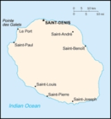
Réunion
is an island in Southern Africa
, in the Indian Ocean
, east of Madagascar
. It is an overseas region of France
. The total area of the island is 2,512 km², of which 10 km² is water. The island has a coastline of 207 km. The maritime claims of Réunion include an exclusive economic zone
of 200 nautical miles, and a territorial sea of 12 nautical miles (22.2 km).
in Réunion is tropical
, but temperature moderates with elevation. The weather is cool and dry from May to November, and hot and rainy from November to April. The terrain
is mostly rugged and mountainous, with fertile lowlands along the coast. The lowest point is the Indian Ocean
and the highest is Piton des Neiges
at 3,069 m.
. As of 1993, 60 km² of the land is irrigated
. The use of the land, as of 1993, is described in the table below:
(2,631 m) on the southeastern coast is an active volcano
.
Réunion
Réunion is a French island with a population of about 800,000 located in the Indian Ocean, east of Madagascar, about south west of Mauritius, the nearest island.Administratively, Réunion is one of the overseas departments of France...
is an island in Southern Africa
Africa
Africa is the world's second largest and second most populous continent, after Asia. At about 30.2 million km² including adjacent islands, it covers 6% of the Earth's total surface area and 20.4% of the total land area...
, in the Indian Ocean
Indian Ocean
The Indian Ocean is the third largest of the world's oceanic divisions, covering approximately 20% of the water on the Earth's surface. It is bounded on the north by the Indian Subcontinent and Arabian Peninsula ; on the west by eastern Africa; on the east by Indochina, the Sunda Islands, and...
, east of Madagascar
Madagascar
The Republic of Madagascar is an island country located in the Indian Ocean off the southeastern coast of Africa...
. It is an overseas region of France
France
The French Republic , The French Republic , The French Republic , (commonly known as France , is a unitary semi-presidential republic in Western Europe with several overseas territories and islands located on other continents and in the Indian, Pacific, and Atlantic oceans. Metropolitan France...
. The total area of the island is 2,512 km², of which 10 km² is water. The island has a coastline of 207 km. The maritime claims of Réunion include an exclusive economic zone
Exclusive Economic Zone
Under the law of the sea, an exclusive economic zone is a seazone over which a state has special rights over the exploration and use of marine resources, including production of energy from water and wind. It stretches from the seaward edge of the state's territorial sea out to 200 nautical...
of 200 nautical miles, and a territorial sea of 12 nautical miles (22.2 km).
Climate
The climateClimate
Climate encompasses the statistics of temperature, humidity, atmospheric pressure, wind, rainfall, atmospheric particle count and other meteorological elemental measurements in a given region over long periods...
in Réunion is tropical
Tropical climate
A tropical climate is a climate of the tropics. In the Köppen climate classification it is a non-arid climate in which all twelve months have mean temperatures above...
, but temperature moderates with elevation. The weather is cool and dry from May to November, and hot and rainy from November to April. The terrain
Terrain
Terrain, or land relief, is the vertical and horizontal dimension of land surface. When relief is described underwater, the term bathymetry is used...
is mostly rugged and mountainous, with fertile lowlands along the coast. The lowest point is the Indian Ocean
Indian Ocean
The Indian Ocean is the third largest of the world's oceanic divisions, covering approximately 20% of the water on the Earth's surface. It is bounded on the north by the Indian Subcontinent and Arabian Peninsula ; on the west by eastern Africa; on the east by Indochina, the Sunda Islands, and...
and the highest is Piton des Neiges
Piton des Neiges
The Piton des Neiges is a massive 3,069 m shield volcano on Réunion, one of the French volcanic islands in the Mascarene Archipelago in the southwestern Indian Ocean. It is located about east of Madagascar. Piton des Neiges is the highest point on Réunion and is considered to be the highest...
at 3,069 m.
Natural resources
Réunion's natural resources are fish, arable land and hydropowerHydropower
Hydropower, hydraulic power, hydrokinetic power or water power is power that is derived from the force or energy of falling water, which may be harnessed for useful purposes. Since ancient times, hydropower has been used for irrigation and the operation of various mechanical devices, such as...
. As of 1993, 60 km² of the land is irrigated
Irrigation
Irrigation may be defined as the science of artificial application of water to the land or soil. It is used to assist in the growing of agricultural crops, maintenance of landscapes, and revegetation of disturbed soils in dry areas and during periods of inadequate rainfall...
. The use of the land, as of 1993, is described in the table below:
| Use | Percentage of Area |
|---|---|
| arable land | 17 |
| permanent crops | 2 |
| permanent pastures | 5 |
| forests and woodland | 35 |
| other | 41 |
Natural hazards
Local natural hazards include: periodic, devastating cyclones (December to April), and Piton de la FournaisePiton de la Fournaise
Piton de la Fournaise : "Peak of the Furnace" is a shield volcano on the eastern side of Réunion island in the Indian Ocean. It is currently one of the most active volcanoes in the world, along with Kīlauea in the Hawaiian Islands , Stromboli, Etna and Mount Erebus in Antarctica...
(2,631 m) on the southeastern coast is an active volcano
Volcano
2. Bedrock3. Conduit 4. Base5. Sill6. Dike7. Layers of ash emitted by the volcano8. Flank| 9. Layers of lava emitted by the volcano10. Throat11. Parasitic cone12. Lava flow13. Vent14. Crater15...
.