

Geography of Romania
Encyclopedia
With an area of 238,400 square kilometers, Romania
is the twelfth largest country in Europe. Situated in the northeastern portion of the Balkan Peninsula, the country is halfway between the equator and the North Pole
and equidistant from the westernmost part of Europe—the Atlantic Coast
—and the most easterly—the Ural Mountains
. Romania has 3,195 kilometers of border. Republic of Moldova lies to the east, Bulgaria
lies to the south, Serbia
to the southwest, and Hungary
to the west. In the southeast, 245 kilometers of Black Sea
coastline provide an important outlet to the Mediterranean Sea
and the Atlantic Ocean
.
Traditionally Romania is divided into several historic regions that no longer perform any administrative function:
Romania's exterior boundaries are a result of relatively recent events. At the outbreak of World War I
, the country's territory included only the provinces of Walachia, Moldavia, and Dobruja. This area, known as the Regat or the Old Kingdom, came into being with the disintegration of the Ottoman Empire
in the mid-nineteenth century. At the end of World War I, Romania acquired Transylvania and the Banat. Some of this territory was lost during World War II
, but negotiations returned it to Romania. Although this acquisition united some 85 percent of the Romanian-speaking population of Eastern Europe into one nation, it left a considerable number of ethnic Hungarians under Romanian rule. Disputes between Hungary and Romania regarding this territory would surface regularly, as both considered the region part of their national heritage. Questions were also periodically raised as to the historical validity of the Soviet-Romanian border. Bukovina and Bessarabia, former Romanian provinces where significant percentages of the population are Romanian-speaking, were part of the Soviet Union
from the end of World War II to its dissolution, and subsequently part of the (formerly Soviet) states of Ukraine
and Moldova
. Despite ongoing and potential disputes, however, it was unlikely in 1989 that Romania's borders would be redrawn in the foreseeable future.
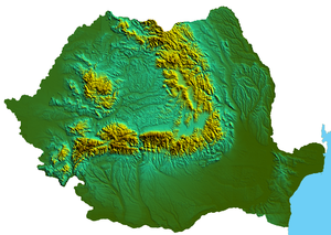
 Romania's natural landscape is almost evenly divided among mountains (31 percent), hills (33 percent), and plains (36 percent). These varied relief forms spread rather symmetrically from the Carpathian Mountains, which reach elevations of more than 2,500 meters, to the Danube Delta, which is just a few meters above sea level.
The arc of the Carpathians extends over 1,000 kilometers through the center of the country, covering an area of 71,000 square kilometers. These mountains are of low to medium altitude and are no wider than 100 kilometers. They are deeply fragmented by longitudinal and transverse valleys and crossed by several major rivers. These features and the fact that there are many summit passes—some at altitudes up to 2,256 meters—have made the Carpathians less of a barrier to movement than other European ranges. Another distinguishing feature is the many eroded platforms that provide tableland at relatively high altitudes. There are permanent settlements here at above 1,200 meters.
Romania's Carpathians are differentiated into three ranges: the Eastern Carpathians, the Southern Carpathians
or Transylvanian Alps, and the Western Carpathians
. Each of these ranges has important distinguishing features. The Eastern Carpathians are composed of three parallel ridges that run from northwest to southeast. The westernmost ridge is an extinct volcanic range with many preserved cones and craters. The range has many large depressions, in the largest of which the city of Braşov
is situated. Important mining and industrial centers as well as agricultural areas are found within these depressions. The Eastern Carpathians are covered with forests—some 32 percent of the country's woodlands are there. They also contain important ore deposits, including gold and silver, and their mineral water springs feed numerous health resorts.
 The Southern Carpathians
offer the highest peaks at Moldoveanu Peak
(2,544 m) and Negoiu
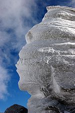
(2,535 m) and more than 150 glacial lakes. They have large grassland areas and some woodlands but few large depressions and subsoil resources. At higher elevations, the wind and rain have turned the rock
s into spectacular figures such as the Sphinx
and Babele
.
The region was crisscrossed by an ancient network of trans-Carpathian roads, and vestiges of the old Roman Way are still visible. Numerous passes and the valleys of the Olt, Jiu, and Danube rivers provide routes for roads and railways through the mountains.
The Western Carpathians
are the lowest of the three ranges and are fragmented by many deep structural depressions. They have historically functioned as "gates," which allow easy passage but can be readily defended. The most famous of these is the Iron Gate
on the Danube. The Western Carpathians are the most densely settled, and it is in the northernmost area of this range, the Apuseni Mountains, that permanent settlements can be found at the highest altitudes.
Enclosed within the great arc of the Carpathians lie the undulating plains and low hills of the Transylvanian Plateau
--the largest tableland in the country and the center of Romania. This important agricultural region also contains large deposits of methane gas and salt. To the south and east of the Carpathians, the Sub-Carpathians form a fringe of rolling terrain ranging from 396 to 1,006 meters in elevation. This terrain is matched in the west by the slightly lower Western Hills. The symmetry of Romania's relief continues with the Getic Tableland to the south of the SubCarpathians, the Moldavian Tableland in the east between the SubCarpathians and the Prut River, and the Dobrujan Tableland in the southeast between the Danube and the Black Sea. The Sub-Carpathians and the tableland areas provide good conditions for human settlement and are important areas for fruit growing, viticulture, and other agricultural activity. They also contain large deposits of brown coal
and natural gas
.
Beyond the Carpathian foothills and tablelands, the plains spread south and west. In the southern parts of the country, the lower Danube Plain is divided by the Olt River; east of the river lies the Wallachian Plain, and to the west is the Oltenian or Western Plain. The land here is rich with chernozem
ic soils and forms Romania's most important farming region. Irrigation is widely used, and marshlands in the Danube's floodplain have been diked and drained to provide additional tillable land.
Romania's lowest land is found on the northern edge of the Dobruja
region in the Danube Delta
. The delta is a triangular swampy area of marshes, floating reed islands, and sandbanks, where the Danube ends its trek of almost 3,000 kilometers and divides into three frayed branches before emptying into the Black Sea. The Danube Delta provides a large part of the country's fish production, and its reeds are used to manufacture cellulose. The region also serves as a nature preserve for rare species of plant and animal life including migratory birds.
, the Olt River
, the Prut
, the Siret River
, the Ialomiţa River
, the Someş River
, and the Argeş River
. Romania's rivers primarily flow east, west, and south from the central crown of the Carpathians. They are fed by rainfall and melting snow, which causes considerable fluctuation in discharge and occasionally catastrophic flooding. In the east, river waters are collected by the Siret
and the Prut
. In the south, the rivers flow directly into the Danube, and in the west, waters are collected by the Tisza
on Hungarian territory.
The Danube is by far Romania's most important river, not only for transportation, but also for the production of hydroelectric power. One of Europe's largest hydroelectric stations is located at the Iron Gates, where the Danube surges through the Carpathian gorges. The Danube is an important water route for domestic shipping, as well as international trade. It is navigable for river vessels along its entire Romanian course and for seagoing ships as far as the port of Brăila
. An obvious problem with the use of the Danube for inland transportation is its remoteness from most of the major industrial centers. Moreover, marshy banks and perennial flooding impede navigation in some areas.
Temperate; cold, cloudy winters with frequent snow and fog; sunny summers with frequent showers and thunderstorms. Winters generally are from November to March. The springs are short, occasionally turning right into summer. Summer lasts from May to August. They have a prolonged Autumn, from September to November. The average January temperature is 34 °F (1.1 °C) and the average July temperature is 69 °F (20.6 °C).
Facts: Record High Temperature: 44.5 °C (112.1 °F) - August 10, 1951 South-Eastern Romania; Record Low Temperature: -38.5 °C - January 24, 1942 (Central Romania)
, bordering the Black Sea
and Danube
, with the Carpathian
mountains in its center. Controls most easily traversable land route between the Balkans
, Moldova
and Ukraine
Geographic coordinates:
46°00′N 25°00′E
Extreme points of Romania
:
Area - comparative: slightly larger than Minnesota
.
and separated from the Wallachian Plain on the south by the Transylvanian Alps
Elevation extremes:
Natural resources
Land use:
Irrigated land:
Natural hazards:
earthquakes most severe in south and southwest; geologic structure and climate promote landslides
Environment - international agreements:
Romania
Romania is a country located at the crossroads of Central and Southeastern Europe, on the Lower Danube, within and outside the Carpathian arch, bordering on the Black Sea...
is the twelfth largest country in Europe. Situated in the northeastern portion of the Balkan Peninsula, the country is halfway between the equator and the North Pole
North Pole
The North Pole, also known as the Geographic North Pole or Terrestrial North Pole, is, subject to the caveats explained below, defined as the point in the northern hemisphere where the Earth's axis of rotation meets its surface...
and equidistant from the westernmost part of Europe—the Atlantic Coast
Atlantic Ocean
The Atlantic Ocean is the second-largest of the world's oceanic divisions. With a total area of about , it covers approximately 20% of the Earth's surface and about 26% of its water surface area...
—and the most easterly—the Ural Mountains
Ural Mountains
The Ural Mountains , or simply the Urals, are a mountain range that runs approximately from north to south through western Russia, from the coast of the Arctic Ocean to the Ural River and northwestern Kazakhstan. Their eastern side is usually considered the natural boundary between Europe and Asia...
. Romania has 3,195 kilometers of border. Republic of Moldova lies to the east, Bulgaria
Bulgaria
Bulgaria , officially the Republic of Bulgaria , is a parliamentary democracy within a unitary constitutional republic in Southeast Europe. The country borders Romania to the north, Serbia and Macedonia to the west, Greece and Turkey to the south, as well as the Black Sea to the east...
lies to the south, Serbia
Serbia
Serbia , officially the Republic of Serbia , is a landlocked country located at the crossroads of Central and Southeast Europe, covering the southern part of the Carpathian basin and the central part of the Balkans...
to the southwest, and Hungary
Hungary
Hungary , officially the Republic of Hungary , is a landlocked country in Central Europe. It is situated in the Carpathian Basin and is bordered by Slovakia to the north, Ukraine and Romania to the east, Serbia and Croatia to the south, Slovenia to the southwest and Austria to the west. The...
to the west. In the southeast, 245 kilometers of Black Sea
Black Sea
The Black Sea is bounded by Europe, Anatolia and the Caucasus and is ultimately connected to the Atlantic Ocean via the Mediterranean and the Aegean seas and various straits. The Bosphorus strait connects it to the Sea of Marmara, and the strait of the Dardanelles connects that sea to the Aegean...
coastline provide an important outlet to the Mediterranean Sea
Mediterranean Sea
The Mediterranean Sea is a sea connected to the Atlantic Ocean surrounded by the Mediterranean region and almost completely enclosed by land: on the north by Anatolia and Europe, on the south by North Africa, and on the east by the Levant...
and the Atlantic Ocean
Atlantic Ocean
The Atlantic Ocean is the second-largest of the world's oceanic divisions. With a total area of about , it covers approximately 20% of the Earth's surface and about 26% of its water surface area...
.
Traditionally Romania is divided into several historic regions that no longer perform any administrative function:
- Dobrogea is the easternmost region, extending from the northward course of the Danube to the shores of the Black Sea.
- MoldaviaMoldaviaMoldavia is a geographic and historical region and former principality in Eastern Europe, corresponding to the territory between the Eastern Carpathians and the Dniester river...
stretches from the Eastern Carpathians to the Prut River on the Moldovan and Ukrainian border. - WallachiaWallachiaWallachia or Walachia is a historical and geographical region of Romania. It is situated north of the Danube and south of the Southern Carpathians...
reaches south from the Transylvanian Alps to the Bulgarian border and is divided by the Olt RiverOlt RiverThe Olt River is a river in Romania. It is the longest river flowing exclusively through Romania. Its source is in the Hăşmaş Mountains of the eastern Carpathian Mountains, near the village Bălan. It flows through the Romanian counties Harghita, Covasna, Braşov, Sibiu, Vâlcea and Olt...
into OlteniaOlteniaOltenia is a historical province and geographical region of Romania, in western Wallachia. It is situated between the Danube, the Southern Carpathians and the Olt river ....
on the west and MunteniaMunteniaMuntenia is a historical province of Romania, usually considered Wallachia-proper . It is situated between the Danube , the Carpathian Mountains and Moldavia , and the Olt River to the west...
on the east. The Danube forms a natural border between Muntenia and Dobruja. - The west-central region, known as TransylvaniaTransylvaniaTransylvania is a historical region in the central part of Romania. Bounded on the east and south by the Carpathian mountain range, historical Transylvania extended in the west to the Apuseni Mountains; however, the term sometimes encompasses not only Transylvania proper, but also the historical...
, is delimited by the arc of the Carpathians, which separates it from the Maramureş region in the northwest; by the CrişanaCrisanaCrișana is a geographical and historical region divided today between Romania and Hungary, named after the Criș River and its three tributaries: the Crișul Alb, Crișul Negru and Crișul Repede....
area, which borders Hungary in the west; and by the BanatBanatThe Banat is a geographical and historical region in Central Europe currently divided between three countries: the eastern part lies in western Romania , the western part in northeastern Serbia , and a small...
region of the southwest, which adjoins both HungaryHungaryHungary , officially the Republic of Hungary , is a landlocked country in Central Europe. It is situated in the Carpathian Basin and is bordered by Slovakia to the north, Ukraine and Romania to the east, Serbia and Croatia to the south, Slovenia to the southwest and Austria to the west. The...
and SerbiaSerbiaSerbia , officially the Republic of Serbia , is a landlocked country located at the crossroads of Central and Southeast Europe, covering the southern part of the Carpathian basin and the central part of the Balkans...
. It is these areas west of the Carpathians that contain the highest concentrations of the nation's largest ethnic minorities--HungariansHungarians in RomaniaThe Hungarian minority of Romania is the largest ethnic minority in Romania, consisting of 1,431,807 people and making up 6.6% of the total population, according to the 2002 census....
, GermansTransylvanian SaxonsThe Transylvanian Saxons are a people of German ethnicity who settled in Transylvania from the 12th century onwards.The colonization of Transylvania by Germans was begun by King Géza II of Hungary . For decades, the main task of the German settlers was to defend the southeastern border of the...
, and SerbsSerbsThe Serbs are a South Slavic ethnic group of the Balkans and southern Central Europe. Serbs are located mainly in Serbia, Montenegro and Bosnia and Herzegovina, and form a sizable minority in Croatia, the Republic of Macedonia and Slovenia. Likewise, Serbs are an officially recognized minority in...
.
Romania's exterior boundaries are a result of relatively recent events. At the outbreak of World War I
World War I
World War I , which was predominantly called the World War or the Great War from its occurrence until 1939, and the First World War or World War I thereafter, was a major war centred in Europe that began on 28 July 1914 and lasted until 11 November 1918...
, the country's territory included only the provinces of Walachia, Moldavia, and Dobruja. This area, known as the Regat or the Old Kingdom, came into being with the disintegration of the Ottoman Empire
Ottoman Empire
The Ottoman EmpireIt was usually referred to as the "Ottoman Empire", the "Turkish Empire", the "Ottoman Caliphate" or more commonly "Turkey" by its contemporaries...
in the mid-nineteenth century. At the end of World War I, Romania acquired Transylvania and the Banat. Some of this territory was lost during World War II
World War II
World War II, or the Second World War , was a global conflict lasting from 1939 to 1945, involving most of the world's nations—including all of the great powers—eventually forming two opposing military alliances: the Allies and the Axis...
, but negotiations returned it to Romania. Although this acquisition united some 85 percent of the Romanian-speaking population of Eastern Europe into one nation, it left a considerable number of ethnic Hungarians under Romanian rule. Disputes between Hungary and Romania regarding this territory would surface regularly, as both considered the region part of their national heritage. Questions were also periodically raised as to the historical validity of the Soviet-Romanian border. Bukovina and Bessarabia, former Romanian provinces where significant percentages of the population are Romanian-speaking, were part of the Soviet Union
Soviet Union
The Soviet Union , officially the Union of Soviet Socialist Republics , was a constitutionally socialist state that existed in Eurasia between 1922 and 1991....
from the end of World War II to its dissolution, and subsequently part of the (formerly Soviet) states of Ukraine
Ukraine
Ukraine is a country in Eastern Europe. It has an area of 603,628 km², making it the second largest contiguous country on the European continent, after Russia...
and Moldova
Moldova
Moldova , officially the Republic of Moldova is a landlocked state in Eastern Europe, located between Romania to the West and Ukraine to the North, East and South. It declared itself an independent state with the same boundaries as the preceding Moldavian Soviet Socialist Republic in 1991, as part...
. Despite ongoing and potential disputes, however, it was unlikely in 1989 that Romania's borders would be redrawn in the foreseeable future.
Topography
The arc of the Carpathians extends over 1,000 kilometers through the center of the country, covering an area of 71,000 square kilometers. These mountains are of low to medium altitude and are no wider than 100 kilometers. They are deeply fragmented by longitudinal and transverse valleys and crossed by several major rivers. These features and the fact that there are many summit passes—some at altitudes up to 2,256 meters—have made the Carpathians less of a barrier to movement than other European ranges. Another distinguishing feature is the many eroded platforms that provide tableland at relatively high altitudes. There are permanent settlements here at above 1,200 meters.
Romania's Carpathians are differentiated into three ranges: the Eastern Carpathians, the Southern Carpathians
Southern Carpathians
The Southern Carpathians or the Transylvanian Alps are a group of mountain ranges which divide central and southern Romania, on one side, and Serbia, on the other side. They cover part of the Carpathian Mountains that is located between the Prahova River in the east and the Timiș and Cerna Rivers...
or Transylvanian Alps, and the Western Carpathians
Western Carpathians
The Western Carpathians are a mountain range and geomorphological province that forms the western part of the Carpathian Mountains.The mountain belt stretches from the Low Beskids range of the Eastern Carpathians along the border of Poland with Slovakia toward the Moravian region of the Czech...
. Each of these ranges has important distinguishing features. The Eastern Carpathians are composed of three parallel ridges that run from northwest to southeast. The westernmost ridge is an extinct volcanic range with many preserved cones and craters. The range has many large depressions, in the largest of which the city of Braşov
Brasov
Brașov is a city in Romania and the capital of Brașov County.According to the last Romanian census, from 2002, there were 284,596 people living within the city of Brașov, making it the 8th most populated city in Romania....
is situated. Important mining and industrial centers as well as agricultural areas are found within these depressions. The Eastern Carpathians are covered with forests—some 32 percent of the country's woodlands are there. They also contain important ore deposits, including gold and silver, and their mineral water springs feed numerous health resorts.
Southern Carpathians
The Southern Carpathians or the Transylvanian Alps are a group of mountain ranges which divide central and southern Romania, on one side, and Serbia, on the other side. They cover part of the Carpathian Mountains that is located between the Prahova River in the east and the Timiș and Cerna Rivers...
offer the highest peaks at Moldoveanu Peak
Moldoveanu Peak
Moldoveanu Peak , at 2544 m, is the highest mountain in Romania, located in Argeş County, in the Făgăraş Mountains of the Southern Carpathians....
(2,544 m) and Negoiu
Negoiu
Negoiu Peak is a mountain peak in the Făgăraş Mountains of the Southern Carpathians, being located in Argeş County, Romania, with an altitude of . It is the second highest peak in Romania after Moldoveanu Peak .-External links:*...
(2,535 m) and more than 150 glacial lakes. They have large grassland areas and some woodlands but few large depressions and subsoil resources. At higher elevations, the wind and rain have turned the rock
Rock (geology)
In geology, rock or stone is a naturally occurring solid aggregate of minerals and/or mineraloids.The Earth's outer solid layer, the lithosphere, is made of rock. In general rocks are of three types, namely, igneous, sedimentary, and metamorphic...
s into spectacular figures such as the Sphinx
Sphinx (Romania)
The Sphinx is a natural rock formation in the Bucegi Mountains in Romania. It is placed at an altitude of 2216 m, at a 10 minute walk from the Babele. The first photo of the Great Bucegi Sfinx was probably taken in about the year 1900. This photo was taken from a front position, not from a lateral...
and Babele
Babele
Babele is a name for an area on the Bucegi Mountains plateau in Romania, within the Southern Carpathians.Babele is one of the most popular tourist destinations in the country...
.
The region was crisscrossed by an ancient network of trans-Carpathian roads, and vestiges of the old Roman Way are still visible. Numerous passes and the valleys of the Olt, Jiu, and Danube rivers provide routes for roads and railways through the mountains.
The Western Carpathians
Western Carpathians
The Western Carpathians are a mountain range and geomorphological province that forms the western part of the Carpathian Mountains.The mountain belt stretches from the Low Beskids range of the Eastern Carpathians along the border of Poland with Slovakia toward the Moravian region of the Czech...
are the lowest of the three ranges and are fragmented by many deep structural depressions. They have historically functioned as "gates," which allow easy passage but can be readily defended. The most famous of these is the Iron Gate
Iron Gate (Danube)
The Iron Gates The gorge lies between Romania in the north and Serbia in the south. At this point, the river separates the southern Carpathian Mountains from the northwestern foothills of the Balkan Mountains. The Romanian, Hungarian, Slovakian, Turkish, German and Bulgarian names literally mean...
on the Danube. The Western Carpathians are the most densely settled, and it is in the northernmost area of this range, the Apuseni Mountains, that permanent settlements can be found at the highest altitudes.
Enclosed within the great arc of the Carpathians lie the undulating plains and low hills of the Transylvanian Plateau
Transylvanian Plateau
The Transylvanian Plateau is a plateau in central Romania.The plateau lies within and takes its name from the historical region of Transylvania, and is almost entirely surrounded by the Eastern, Southern and Romanian Western branches of the Carpathian Mountains...
--the largest tableland in the country and the center of Romania. This important agricultural region also contains large deposits of methane gas and salt. To the south and east of the Carpathians, the Sub-Carpathians form a fringe of rolling terrain ranging from 396 to 1,006 meters in elevation. This terrain is matched in the west by the slightly lower Western Hills. The symmetry of Romania's relief continues with the Getic Tableland to the south of the SubCarpathians, the Moldavian Tableland in the east between the SubCarpathians and the Prut River, and the Dobrujan Tableland in the southeast between the Danube and the Black Sea. The Sub-Carpathians and the tableland areas provide good conditions for human settlement and are important areas for fruit growing, viticulture, and other agricultural activity. They also contain large deposits of brown coal
Lignite
Lignite, often referred to as brown coal, or Rosebud coal by Northern Pacific Railroad,is a soft brown fuel with characteristics that put it somewhere between coal and peat...
and natural gas
Natural gas
Natural gas is a naturally occurring gas mixture consisting primarily of methane, typically with 0–20% higher hydrocarbons . It is found associated with other hydrocarbon fuel, in coal beds, as methane clathrates, and is an important fuel source and a major feedstock for fertilizers.Most natural...
.
Beyond the Carpathian foothills and tablelands, the plains spread south and west. In the southern parts of the country, the lower Danube Plain is divided by the Olt River; east of the river lies the Wallachian Plain, and to the west is the Oltenian or Western Plain. The land here is rich with chernozem
Chernozem
Chernozem , also known as "black land" or "black earth", is a black-coloured soil containing a high percentage of humus 7% to 15%, and high percentages of phosphoric acids, phosphorus and ammonia...
ic soils and forms Romania's most important farming region. Irrigation is widely used, and marshlands in the Danube's floodplain have been diked and drained to provide additional tillable land.
Romania's lowest land is found on the northern edge of the Dobruja
Dobruja
Dobruja is a historical region shared by Bulgaria and Romania, located between the lower Danube river and the Black Sea, including the Danube Delta, Romanian coast and the northernmost part of the Bulgarian coast...
region in the Danube Delta
Danube Delta
The Danube Delta is the second largest river delta in Europe, after the Volga Delta, and is the best preserved on the continent. The greater part of the Danube Delta lies in Romania , while its northern part, on the left bank of the Chilia arm, is situated in Ukraine . The approximate surface is...
. The delta is a triangular swampy area of marshes, floating reed islands, and sandbanks, where the Danube ends its trek of almost 3,000 kilometers and divides into three frayed branches before emptying into the Black Sea. The Danube Delta provides a large part of the country's fish production, and its reeds are used to manufacture cellulose. The region also serves as a nature preserve for rare species of plant and animal life including migratory birds.
Hydrography
Rivers
After entering the country in the southwest at Bazias, the Danube travels some 1,075 kilometers (almost 40% of its entire length) through or along Romanian territory, forming the southern frontier with Serbia and Bulgaria. Virtually all of the country's rivers are tributaries of the Danube, either directly or indirectly, and by the time the Danube's course ends in the Black Sea, they account for nearly 40 percent of the total discharge. The most important of these rivers are the Mureş RiverMures River
The Mureș is an approximately 761 km long river in Eastern Europe. It originates in the Hășmașu Mare Range in the Eastern Carpathian Mountains, Romania, and joins the Tisza river at Szeged in southeastern Hungary....
, the Olt River
Olt River
The Olt River is a river in Romania. It is the longest river flowing exclusively through Romania. Its source is in the Hăşmaş Mountains of the eastern Carpathian Mountains, near the village Bălan. It flows through the Romanian counties Harghita, Covasna, Braşov, Sibiu, Vâlcea and Olt...
, the Prut
Prut
The Prut is a long river in Eastern Europe. In part of its course it forms the border between Romania and Moldova.-Overview:...
, the Siret River
Siret River
The Siret or Sireth is a river that rises from the Carpathians in the Northern Bukovina region of Ukraine, and flows southward into Romania for 470 km before it joins the Danube...
, the Ialomiţa River
Ialomita River
The Ialomiţa is a river of Southern Romania that rises from the Bucegi Mountains in the Carpathians and flows into the Danube.The upper reach of the river is sometimes known as Valea Obârşiei or Obârşia Ialomiţei.-Localities:...
, the Someş River
Someş River
The river Someş flows through Romania and Hungary.It rises from two headstreams, the Someşul Mare, in the Rodna Mountains in Bistriţa-Năsăud County and the Someşul Mic in the Apuseni Mountains of Cluj County...
, and the Argeş River
Arges River
Argeș is a river of Southern Romania. It starts at the junction of headwaters Buda and Capra in the Făgăraș Mountains, in the Southern Carpathians and flows into the Danube at Oltenița.The main city on the Argeş is Piteşti...
. Romania's rivers primarily flow east, west, and south from the central crown of the Carpathians. They are fed by rainfall and melting snow, which causes considerable fluctuation in discharge and occasionally catastrophic flooding. In the east, river waters are collected by the Siret
Siret
Siret is a town in Romania, Suceava County, one of the oldest towns in, and a former capital of, the former principality of Moldavia. It is located 2 km from the border with Ukraine, being one of the main border passing points in the North of the country, having both a road border post and a...
and the Prut
Prut
The Prut is a long river in Eastern Europe. In part of its course it forms the border between Romania and Moldova.-Overview:...
. In the south, the rivers flow directly into the Danube, and in the west, waters are collected by the Tisza
Tisza
The Tisza or Tisa is one of the main rivers of Central Europe. It rises in Ukraine, and is formed near Rakhiv by the junction of headwaters White Tisa, whose source is in the Chornohora mountains and Black Tisa, which springs in the Gorgany range...
on Hungarian territory.
The Danube is by far Romania's most important river, not only for transportation, but also for the production of hydroelectric power. One of Europe's largest hydroelectric stations is located at the Iron Gates, where the Danube surges through the Carpathian gorges. The Danube is an important water route for domestic shipping, as well as international trade. It is navigable for river vessels along its entire Romanian course and for seagoing ships as far as the port of Brăila
Braila
Brăila is a city in Muntenia, eastern Romania, a port on the Danube and the capital of Brăila County, in the close vicinity of Galaţi.According to the 2002 Romanian census there were 216,292 people living within the city of Brăila, making it the 10th most populous city in Romania.-History:A...
. An obvious problem with the use of the Danube for inland transportation is its remoteness from most of the major industrial centers. Moreover, marshy banks and perennial flooding impede navigation in some areas.
Climate
Because of its position on the southeastern portion of the European continent, Romania has a climate that is transitional between temperate and continental. Climatic conditions are somewhat modified by the country's varied relief. The Carpathians serve as a barrier to Atlantic air masses, restricting their oceanic influences to the west and center of the country, where they make for milder winters and heavier rainfall. The mountains also block the continental influences of the vast plain to the north in Ukraine, which bring frosty winters and less rain to the south and southeast. In the extreme southeast, Mediterranean influences offer a milder, maritime climate. The average annual temperature is 11 °C (51.8 °F) in the south and 8 °C (46.4 °F) in the north. In Bucharest, the temperature ranges from -29 °C in January to 29 °C (84.2 °F) in July, with average temperatures of -3 °C in January and 23 °C (73.4 °F) in July. Rainfall, although adequate throughout the country, decreases from west to east and from mountains to plains. Some mountainous areas receive more than 1010 mm (39.8 in) of precipitation each year. Annual precipitation averages about 635 mm (25 in) in central Transylvania, 521 mm (20.5 in) at Iaşi in Moldavia, and only 381 mm (15 in) at Constanţa on the Black Sea.Temperate; cold, cloudy winters with frequent snow and fog; sunny summers with frequent showers and thunderstorms. Winters generally are from November to March. The springs are short, occasionally turning right into summer. Summer lasts from May to August. They have a prolonged Autumn, from September to November. The average January temperature is 34 °F (1.1 °C) and the average July temperature is 69 °F (20.6 °C).
Facts: Record High Temperature: 44.5 °C (112.1 °F) - August 10, 1951 South-Eastern Romania; Record Low Temperature: -38.5 °C - January 24, 1942 (Central Romania)
Location
Southeastern EuropeEurope
Europe is, by convention, one of the world's seven continents. Comprising the westernmost peninsula of Eurasia, Europe is generally 'divided' from Asia to its east by the watershed divides of the Ural and Caucasus Mountains, the Ural River, the Caspian and Black Seas, and the waterways connecting...
, bordering the Black Sea
Black Sea
The Black Sea is bounded by Europe, Anatolia and the Caucasus and is ultimately connected to the Atlantic Ocean via the Mediterranean and the Aegean seas and various straits. The Bosphorus strait connects it to the Sea of Marmara, and the strait of the Dardanelles connects that sea to the Aegean...
and Danube
Danube
The Danube is a river in the Central Europe and the Europe's second longest river after the Volga. It is classified as an international waterway....
, with the Carpathian
Carpathian Mountains
The Carpathian Mountains or Carpathians are a range of mountains forming an arc roughly long across Central and Eastern Europe, making them the second-longest mountain range in Europe...
mountains in its center. Controls most easily traversable land route between the Balkans
Balkans
The Balkans is a geopolitical and cultural region of southeastern Europe...
, Moldova
Moldova
Moldova , officially the Republic of Moldova is a landlocked state in Eastern Europe, located between Romania to the West and Ukraine to the North, East and South. It declared itself an independent state with the same boundaries as the preceding Moldavian Soviet Socialist Republic in 1991, as part...
and Ukraine
Ukraine
Ukraine is a country in Eastern Europe. It has an area of 603,628 km², making it the second largest contiguous country on the European continent, after Russia...
Geographic coordinates:
46°00′N 25°00′E
Extreme points of Romania
Extreme points of Romania
This is a list of the extreme points of Romania, the points that are farther north, south, east or west than any other location.-Latitude and longitude:*Northernmost point: Horodiştea, a village in Botoşani County, on the border with Ukraine,...
:
- Northernmost point: Horodiştea, a village in Botoşani CountyBotosani CountyBotoșani is a county of Romania, in Moldavia, with the capital city at Botoșani.-Demographics:In 2002, it had a population of 452,834 and the population density was 91/km2.*Romanians – – the highest percentage of Romanians in Romania...
, on the border with UkraineUkraineUkraine is a country in Eastern Europe. It has an area of 603,628 km², making it the second largest contiguous country on the European continent, after Russia...
, 48°15′N 26°42′E - Southernmost point: ZimniceaZimniceaZimnicea is a town in Teleorman county, Romania , a port on the Danube opposite the Bulgarian city of Svishtov.-Geography:...
, a town in Teleorman CountyTeleorman CountyTeleorman is a county of Romania, in the historical region Muntenia, with its capital city at Alexandria.The name Teleorman is of Cumanic origin. It literally means crazy forest and, by extension, "thick and shadowy forest" in the Cuman language...
, on the border with BulgariaBulgariaBulgaria , officially the Republic of Bulgaria , is a parliamentary democracy within a unitary constitutional republic in Southeast Europe. The country borders Romania to the north, Serbia and Macedonia to the west, Greece and Turkey to the south, as well as the Black Sea to the east...
, 43°37′N 25°23′E - Westernmost point: Beba Veche, a village in Timiş CountyTimis CountyTimiș , , Banat Bulgarian: ) is a county of western Romania, in the historical region Banat, with the county seat at Timișoara. It is the largest county in Romania in terms of land area....
, on the border with HungaryHungaryHungary , officially the Republic of Hungary , is a landlocked country in Central Europe. It is situated in the Carpathian Basin and is bordered by Slovakia to the north, Ukraine and Romania to the east, Serbia and Croatia to the south, Slovenia to the southwest and Austria to the west. The...
and SerbiaSerbiaSerbia , officially the Republic of Serbia , is a landlocked country located at the crossroads of Central and Southeast Europe, covering the southern part of the Carpathian basin and the central part of the Balkans...
, 46°07′N 20°15′E - Easternmost point: SulinaSulinaSulina is a town and free port in Tulcea County, Romania, at the mouth of the Sulina branch of the Danube. It is the easternmost point of Romania and of the continental European Union.-History:...
, a town in Tulcea CountyTulcea CountyTulcea is a county of Romania, in the historical region Dobruja, with the capital city at Tulcea.-Demographics:In 2002, Tulcea County had a population of 256,492...
, on the Danube DeltaDanube DeltaThe Danube Delta is the second largest river delta in Europe, after the Volga Delta, and is the best preserved on the continent. The greater part of the Danube Delta lies in Romania , while its northern part, on the left bank of the Chilia arm, is situated in Ukraine . The approximate surface is...
, 45°09′N 29°41′E
Area
- total: 238,391 km²
- land: 231,231 km²
- water: 7,160 km²
Area - comparative: slightly larger than Minnesota
Minnesota
Minnesota is a U.S. state located in the Midwestern United States. The twelfth largest state of the U.S., it is the twenty-first most populous, with 5.3 million residents. Minnesota was carved out of the eastern half of the Minnesota Territory and admitted to the Union as the thirty-second state...
.
Land boundaries
- total: 3,149.9 km
- border countries: BulgariaBulgariaBulgaria , officially the Republic of Bulgaria , is a parliamentary democracy within a unitary constitutional republic in Southeast Europe. The country borders Romania to the north, Serbia and Macedonia to the west, Greece and Turkey to the south, as well as the Black Sea to the east...
631 km, HungaryHungaryHungary , officially the Republic of Hungary , is a landlocked country in Central Europe. It is situated in the Carpathian Basin and is bordered by Slovakia to the north, Ukraine and Romania to the east, Serbia and Croatia to the south, Slovenia to the southwest and Austria to the west. The...
448 km, MoldovaMoldovaMoldova , officially the Republic of Moldova is a landlocked state in Eastern Europe, located between Romania to the West and Ukraine to the North, East and South. It declared itself an independent state with the same boundaries as the preceding Moldavian Soviet Socialist Republic in 1991, as part...
681 km, SerbiaSerbiaSerbia , officially the Republic of Serbia , is a landlocked country located at the crossroads of Central and Southeast Europe, covering the southern part of the Carpathian basin and the central part of the Balkans...
546 km, UkraineUkraineUkraine is a country in Eastern Europe. It has an area of 603,628 km², making it the second largest contiguous country on the European continent, after Russia...
(north and east) 649 km.
Coastline
193.5 km- Maritime claims: Snake IslandSnake Island (Black Sea)Snake Island, also known as Serpent Island, , is a Ukrainian island located in the Black Sea near the Danube Delta.The island is populated. A rural settlement of Bile was established in February 2007, which is part of the Vylkove city, Kiliya Raion, Odessa Oblast...
- contiguous zone: 24 nmi (44.4 km; 27.6 mi)
- continental shelf: 200 m depth or to the depth of exploitation
- exclusive economic zone: 200 nmi (370.4 km; 230.2 mi)
- territorial sea: 12 nmi (22.2 km; 13.8 mi)
Terrain
Central Transylvanian Basin is separated from the Plain of Moldavia on the east by the Carpathian MountainsCarpathian Mountains
The Carpathian Mountains or Carpathians are a range of mountains forming an arc roughly long across Central and Eastern Europe, making them the second-longest mountain range in Europe...
and separated from the Wallachian Plain on the south by the Transylvanian Alps
Elevation extremes:
- lowest point: Black SeaBlack SeaThe Black Sea is bounded by Europe, Anatolia and the Caucasus and is ultimately connected to the Atlantic Ocean via the Mediterranean and the Aegean seas and various straits. The Bosphorus strait connects it to the Sea of Marmara, and the strait of the Dardanelles connects that sea to the Aegean...
0 m - highest point: Moldoveanu PeakMoldoveanu PeakMoldoveanu Peak , at 2544 m, is the highest mountain in Romania, located in Argeş County, in the Făgăraş Mountains of the Southern Carpathians....
2,544 m
Natural resources
- petroleum (reserves steady to declining), timber, natural gas, coal, iron ore, salt, arable land, hydro power
Land use:
- arable land: 41%
- permanent crops: 3%
- permanent pastures: 21%
- forests and woodland: 29%
- other: 6% (1993 est.)
Irrigated land:
- 31,020 km² (1993 est.)
Natural hazards:
earthquakes most severe in south and southwest; geologic structure and climate promote landslides
Environment
Environment - current issues: soil erosion and degradation; water pollution; air pollution in south from industrial effluents; contamination of Danube delta wetlandsEnvironment - international agreements:
- party to: Air Pollution, Antarctic Treaty, Biodiversity, Climate Change, Desertification, Endangered Species, Environmental Modification, Hazardous Wastes, Law of the Sea, Nuclear Test Ban, Ozone Layer Protection, Ship Pollution, Wetlands
- signed, but not ratified: Air Pollution-Persistent Organic Pollutants, Antarctic-Environmental Protocol, Climate Change-Kyoto ProtocolKyoto ProtocolThe Kyoto Protocol is a protocol to the United Nations Framework Convention on Climate Change , aimed at fighting global warming...
See also
- List of cities in Romania
- Reservoirs and dams in Romania
- List of mountain peaks in Romania