

Geography of Qatar
Encyclopedia
Qatar
Qatar , also known as the State of Qatar or locally Dawlat Qaṭar, is a sovereign Arab state, located in the Middle East, occupying the small Qatar Peninsula on the northeasterly coast of the much larger Arabian Peninsula. Its sole land border is with Saudi Arabia to the south, with the rest of its...
is a peninsula
Peninsula
A peninsula is a piece of land that is bordered by water on three sides but connected to mainland. In many Germanic and Celtic languages and also in Baltic, Slavic and Hungarian, peninsulas are called "half-islands"....
in the east of Arabia, bordering the Persian Gulf
Persian Gulf
The Persian Gulf, in Southwest Asia, is an extension of the Indian Ocean located between Iran and the Arabian Peninsula.The Persian Gulf was the focus of the 1980–1988 Iran-Iraq War, in which each side attacked the other's oil tankers...
and Saudi Arabia
Saudi Arabia
The Kingdom of Saudi Arabia , commonly known in British English as Saudi Arabia and in Arabic as as-Sa‘ūdiyyah , is the largest state in Western Asia by land area, constituting the bulk of the Arabian Peninsula, and the second-largest in the Arab World...
, in a strategic location near major petroleum
Petroleum
Petroleum or crude oil is a naturally occurring, flammable liquid consisting of a complex mixture of hydrocarbons of various molecular weights and other liquid organic compounds, that are found in geologic formations beneath the Earth's surface. Petroleum is recovered mostly through oil drilling...
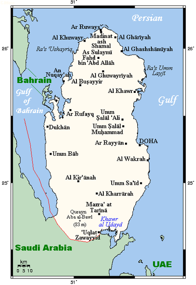
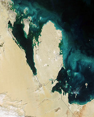
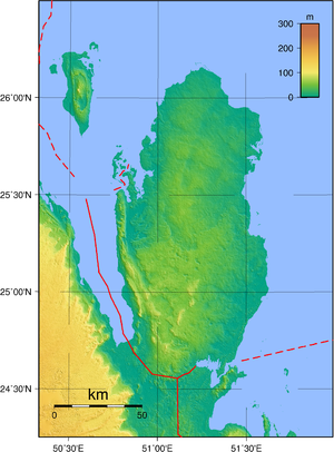
deposits. Qatar occupies 11,437 square kilometers on a peninsula that extends approximately 160 kilometers north into the Persian Gulf from the Arabian Peninsula. Varying in width between fifty-five and ninety kilometers, the land is mainly flat (the highest point is 103 meters) and rocky. Notable features include coastal salt pans, elevated limestone formations (the Dukhan anticline) along the west coast under which lies the Dukhan oil field, and massive sand dunes surrounding Khawr al Udayd
Khawr al Udayd
Khawr al Udayd, also spelled Khor al Adaid, is an inlet of the Persian Gulf in the southeast of Qatar. It is known to local English speakers as the "Inland Sea".-External links:*...
, an inlet of the gulf in the southeast known to local English speakers as the Inland Sea. Of the islands belonging to Qatar, Halul is the most important. Lying about ninety kilometers east of Doha
Doha
Doha is the capital city of the state of Qatar. Located on the Persian Gulf, it had a population of 998,651 in 2008, and is also one of the municipalities of Qatar...
, it serves as a storage area and loading terminal for oil from the surrounding offshore fields. Hawar and the adjacent islands
Hawar Islands
The Hawar Islands are a group of islands situated off the west coast of Qatar in the Gulf of Bahrain of the Persian Gulf.Despite their proximity to Qatar , the islands...
immediately off the west coast are the subject of a territorial dispute between Qatar and Bahrain
Bahrain
' , officially the Kingdom of Bahrain , is a small island state near the western shores of the Persian Gulf. It is ruled by the Al Khalifa royal family. The population in 2010 stood at 1,214,705, including 235,108 non-nationals. Formerly an emirate, Bahrain was declared a kingdom in 2002.Bahrain is...
.
The capital, Doha, is located on the central east coast on a sweeping (if shallow) harbor. Other ports include Umm Said, Al Khawr
Al Khawr
Al Khawr, also spelled Al Khor, may refer to:*Al Khor, a town located in northern Qatar.*Al Khor Municipality, the municipality in which Al Khor town is located in.*Al Khawr, Yemen...
, and Al Wakrah
Al Wakrah
Al Wakrah is a city and municipality of Qatar located halfway between Ad Dawhah and Mesaieed municipalities. Al Wakrah's eastern edge is the shores of the Persian Gulf. Originally al wakra was a tiny fishing and pearling village. Now it has evolved into a small town with a population of more than...
. Only Doha and Umm Said are capable of handling commercial shipping, although a large port and a terminal for loading natural gas are planned at Ras Laffan Industrial City
Ras Laffan Industrial City
Ras Laffan Industrial City is an industrial hub located north of Doha, Qatar. It is administrated by Qatar Petroleum.Ras Laffan Industrial City is the Qatar's main site for production of liquefied natural gas and gas-to-liquid...
, north of Al Khawr. Coral reefs and shallow coastal waters make navigation difficult in areas where channels have not been dredged.
Qatar shares its land border with Saudi Arabia
Saudi Arabia
The Kingdom of Saudi Arabia , commonly known in British English as Saudi Arabia and in Arabic as as-Sa‘ūdiyyah , is the largest state in Western Asia by land area, constituting the bulk of the Arabian Peninsula, and the second-largest in the Arab World...
. The boundary with Saudi Arabia was settled in 1965 but never demarcated. Qatar's northwest coast is fewer than thirty kilometers from the main islands of Bahrain; however, Qatar's northwest coast is only 1.4 kilometers from the Hawar Islands of Bahrain.
Doha is the capital of the country and the major administrative, commercial, and population center. In 1993 it was linked to other towns and development sites by a system of about 1,000 kilometers of paved roads. Doha's international airport has an approximately 4,500-meter main runway, capable of receiving all kinds of aircraft.
Geographic coordinates: 25°30′N 51°15′E
Climate
The long summer (May through September) is characterized by intense heat and alternating dryness and humidity, with temperatures reaching 50 °C (122 °F). Temperatures are moderate from November through May, although winter temperatures may fall to 5 °C (41 °F). Rainfall is negligible, averaging 100 millimetres (3.9 in) per year, confined to the winter months, and falling in brief, sometimes heavy storms that often flood the small ravines and the usually dry wadis. Sudden, violent dust storms occasionally descend on the peninsula, blotting out the sun, causing wind damage, and momentarily disrupting transport and other services.The scarcity of rainfall and the limited underground water, most of which has such a high mineral content that it is unsuitable for drinking or irrigation, restricted the population and the extent of agricultural and industrial development the country could support until desalination projects began. Although water continues to be provided from underground sources, most is obtained by desalination of seawater.
Vegetation zones
Although most of the country consists of sandSand
Sand is a naturally occurring granular material composed of finely divided rock and mineral particles.The composition of sand is highly variable, depending on the local rock sources and conditions, but the most common constituent of sand in inland continental settings and non-tropical coastal...
desert
Desert
A desert is a landscape or region that receives an extremely low amount of precipitation, less than enough to support growth of most plants. Most deserts have an average annual precipitation of less than...
s, a small part of the country houses different vegetation
Vegetation
Vegetation is a general term for the plant life of a region; it refers to the ground cover provided by plants. It is a general term, without specific reference to particular taxa, life forms, structure, spatial extent, or any other specific botanical or geographic characteristics. It is broader...
zones, where trees, reeds and shrubs like tamarind
Tamarind
Tamarind is a tree in the family Fabaceae. The genus Tamarindus is monotypic .-Origin:...
, phragmites
Phragmites
Phragmites, the Common reed, is a large perennial grass found in wetlands throughout temperate and tropical regions of the world. Phragmites australis is sometimes regarded as the sole species of the genus Phragmites, though some botanists divide Phragmites australis into three or four species...
, and mace can grow. These regions are mostly to the east, near the coast.
Area and land boundaries
Area:total:
11,437 km²
land:
11,437 km²
water:
0 km²
Land boundaries:
total:
60 km
border countries:
Saudi Arabia 60 km
Coastline:
563 km
Maritime claims:
contiguous zone:
24 nmi (44.4 km; 27.6 mi)
exclusive economic zone:
as determined by bilateral agreements, or the median line
territorial sea:
12 nmi (22.2 km; 13.8 mi)
Elevation extremes:
lowest point:
Persian Gulf 0 m
highest point:
Qurayn Abu al Bawl
Qurayn Abu al Bawl
Qurayn Abu al Bawl is the highest point of Qatar, with an altitude of 103 metres .-External links: , WorldCityDB.com....
103 metres / 343 feet
Resources and land use
Natural resources:petroleum
Petroleum
Petroleum or crude oil is a naturally occurring, flammable liquid consisting of a complex mixture of hydrocarbons of various molecular weights and other liquid organic compounds, that are found in geologic formations beneath the Earth's surface. Petroleum is recovered mostly through oil drilling...
, natural gas
Natural gas
Natural gas is a naturally occurring gas mixture consisting primarily of methane, typically with 0–20% higher hydrocarbons . It is found associated with other hydrocarbon fuel, in coal beds, as methane clathrates, and is an important fuel source and a major feedstock for fertilizers.Most natural...
, fish
Fish
Fish are a paraphyletic group of organisms that consist of all gill-bearing aquatic vertebrate animals that lack limbs with digits. Included in this definition are the living hagfish, lampreys, and cartilaginous and bony fish, as well as various extinct related groups...
Land use:
arable land:
1%
permanent crops:
0%
permanent pastures:
5%
forests and woodland:
0%
other:
94% (1993 est.)
Irrigated land:
80 km² (1993 est.)
Environmental concerns
Natural hazards:haze, dust storms, sandstorms common
Environment - current issues:
limited natural fresh water resources are increasing dependence on large-scale desalination facilities
Environment - international agreements:
party to:
Biodiversity
Biodiversity
Biodiversity is the degree of variation of life forms within a given ecosystem, biome, or an entire planet. Biodiversity is a measure of the health of ecosystems. Biodiversity is in part a function of climate. In terrestrial habitats, tropical regions are typically rich whereas polar regions...
, Climate Change
United Nations Framework Convention on Climate Change
The United Nations Framework Convention on Climate Change is an international environmental treaty produced at the United Nations Conference on Environment and Development , informally known as the Earth Summit, held in Rio de Janeiro from June 3 to 14, 1992...
, Desertification
Desertification
Desertification is the degradation of land in drylands. Caused by a variety of factors, such as climate change and human activities, desertification is one of the most significant global environmental problems.-Definitions:...
, Hazardous Wastes, Law of the Sea
Law of the sea
Law of the sea may refer to:* United Nations Convention on the Law of the Sea* Admiralty law* The Custom of the Sea...
, Ozone Layer Protection
signed, but not ratified: none of the selected agreements