
Geography of Prince Edward Island
Encyclopedia
Prince Edward Island
's geography is mostly pastoral with red soil, white sand, and scattered communities. Known as the "Garden of the Gulf", the island is located in the Gulf of Saint Lawrence
north of Nova Scotia
and east of New Brunswick
, with which it forms the Northumberland Strait
.
PEI consists of the capital city Charlottetown
, as well as suburban towns Cornwall
and Stratford
and a developing urban fringe. A smaller urban area surrounds Summerside Harbor, situated on the southern shore 40 kilometers west of Charlottetown Harbor, and consists primarily of the city of Summerside
. As with all natural harbors on the island, Charlottetown and Summerside harbors are created by ria
s. (See also a list of communities in Prince Edward Island.)
The island's landscape is pastoral: rolling hills, pristine forests, white sand beaches, ocean coves and the famous red soil have given Prince Edward Island a reputation as a province of outstanding natural beauty. A number of laws have been passed by the provincial government to attempt to preserve the landscape through regulation, although the lack of consistent enforcement and absence of province-wide zoning
and land-use planning has resulted in some aesthetically displeasing development in recent years.
The island's lush landscape has had a strong bearing not only on its economy but also its culture. Author Lucy Maud Montgomery
drew inspiration from the land during the late Victorian Era
for the setting of her classic novel Anne of Green Gables
. Today, many of the same qualities that Montgomery and others found in the Island are enjoyed by tourists who visit during all seasons. They enjoy a variety of leisure activities, including beaches, various golf
courses, eco-tourism adventures, and simply touring the countryside and enjoying cultural events in local communities around the island.
, given that the size of farm properties is quite small when compared with other areas in Canada. There is an increasing amount of industrial farming as older farm properties are consolidated and modernized.
es, dune
s, red sandstone
cliffs, salt water marsh
es and numerous bays
and harbours
. The beaches, dunes and sandstone cliffs consist of sedimentary rock and other material with a high iron
concentration which oxidizes upon exposure to the air. The geological properties of a white silica sand found at Basin Head
are unique in the province; the sand grains cause a scrubbing noise as they rub against each other when walked on. Large dune fields on the north shore can be found on barrier islands at the entrances to various bays and harbours. The magnificent sand dunes at Greenwich
are of particular significance. The shifting, parabolic dune system is home to a variety of birds and rare plants and is also a site of significant archeological interest.
Prince Edward Island
Prince Edward Island is a Canadian province consisting of an island of the same name, as well as other islands. The maritime province is the smallest in the nation in both land area and population...
's geography is mostly pastoral with red soil, white sand, and scattered communities. Known as the "Garden of the Gulf", the island is located in the Gulf of Saint Lawrence
Gulf of Saint Lawrence
The Gulf of Saint Lawrence , the world's largest estuary, is the outlet of North America's Great Lakes via the Saint Lawrence River into the Atlantic Ocean...
north of Nova Scotia
Nova Scotia
Nova Scotia is one of Canada's three Maritime provinces and is the most populous province in Atlantic Canada. The name of the province is Latin for "New Scotland," but "Nova Scotia" is the recognized, English-language name of the province. The provincial capital is Halifax. Nova Scotia is the...
and east of New Brunswick
New Brunswick
New Brunswick is one of Canada's three Maritime provinces and is the only province in the federation that is constitutionally bilingual . The provincial capital is Fredericton and Saint John is the most populous city. Greater Moncton is the largest Census Metropolitan Area...
, with which it forms the Northumberland Strait
Northumberland Strait
The Northumberland Strait is a strait in the southern part of the Gulf of Saint Lawrence in eastern Canada...
.
PEI consists of the capital city Charlottetown
Charlottetown
Charlottetown is a Canadian city. It is both the largest city on and the provincial capital of Prince Edward Island, and the county seat of Queens County. Named after Queen Charlotte, the wife of George III, Charlottetown was first incorporated as a town in 1855 and designated as a city in 1885...
, as well as suburban towns Cornwall
Cornwall, Prince Edward Island
Cornwall is a Canadian suburban town located in Queens County, Prince Edward Island.The town is located immediately west of the provincial capital Charlottetown and functions as a bedroom community.-History:...
and Stratford
Stratford, Prince Edward Island
Stratford is a Canadian suburban town located in central Prince Edward Island.It is situated on a peninsula formed by the Hillsborough River estuary, Charlottetown Harbour, and Hillsborough Bay - a sub-basin of the Northumberland Strait....
and a developing urban fringe. A smaller urban area surrounds Summerside Harbor, situated on the southern shore 40 kilometers west of Charlottetown Harbor, and consists primarily of the city of Summerside
Summerside, Prince Edward Island
Summerside is a Canadian city in Prince County, Prince Edward Island. It is the second largest city in the province and the principal municipality for the western part of the island.- History :...
. As with all natural harbors on the island, Charlottetown and Summerside harbors are created by ria
Ria
A ria is a coastal inlet formed by the partial submergence of an unglaciated river valley. It is a drowned river valley that remains open to the sea. Typically, rias have a dendritic, treelike outline although they can be straight and without significant branches. This pattern is inherited from the...
s. (See also a list of communities in Prince Edward Island.)
The island's landscape is pastoral: rolling hills, pristine forests, white sand beaches, ocean coves and the famous red soil have given Prince Edward Island a reputation as a province of outstanding natural beauty. A number of laws have been passed by the provincial government to attempt to preserve the landscape through regulation, although the lack of consistent enforcement and absence of province-wide zoning
Zoning
Zoning is a device of land use planning used by local governments in most developed countries. The word is derived from the practice of designating permitted uses of land based on mapped zones which separate one set of land uses from another...
and land-use planning has resulted in some aesthetically displeasing development in recent years.
The island's lush landscape has had a strong bearing not only on its economy but also its culture. Author Lucy Maud Montgomery
Lucy Maud Montgomery
Lucy Maud Montgomery OBE , called "Maud" by family and friends and publicly known as L.M. Montgomery, was a Canadian author best known for a series of novels beginning with Anne of Green Gables, published in 1908. Anne of Green Gables was an immediate success...
drew inspiration from the land during the late Victorian Era
Victorian era
The Victorian era of British history was the period of Queen Victoria's reign from 20 June 1837 until her death on 22 January 1901. It was a long period of peace, prosperity, refined sensibilities and national self-confidence...
for the setting of her classic novel Anne of Green Gables
Anne of Green Gables
Anne of Green Gables is a bestselling novel by Canadian author Lucy Maud Montgomery published in 1908. Set in 1878, it was written as fiction for readers of all ages, but in recent decades has been considered a children's book...
. Today, many of the same qualities that Montgomery and others found in the Island are enjoyed by tourists who visit during all seasons. They enjoy a variety of leisure activities, including beaches, various golf
Golf
Golf is a precision club and ball sport, in which competing players use many types of clubs to hit balls into a series of holes on a golf course using the fewest number of strokes....
courses, eco-tourism adventures, and simply touring the countryside and enjoying cultural events in local communities around the island.
Communities
The smaller rural communities as well as the towns and villages throughout the province proudly retain a slower-paced, old world flavor, something that factors heavily into Prince Edward Island's popularity as a destination for relaxation. Most rural communities on Prince Edward Island are based on small-scale agricultureSmall-scale agriculture
Small-scale agriculture is an alternative to factory farming or more broadly, intensive agriculture or unsustainable farming methods that are prevalent in primarily first world countries. Environmental Health Perspectives has noted that " Sustainable agriculture is not merely a package of...
, given that the size of farm properties is quite small when compared with other areas in Canada. There is an increasing amount of industrial farming as older farm properties are consolidated and modernized.
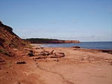
Coastline
The coastline of the island consists of a combination of long beachBeach
A beach is a geological landform along the shoreline of an ocean, sea, lake or river. It usually consists of loose particles which are often composed of rock, such as sand, gravel, shingle, pebbles or cobblestones...
es, dune
Dune
In physical geography, a dune is a hill of sand built by wind. Dunes occur in different forms and sizes, formed by interaction with the wind. Most kinds of dunes are longer on the windward side where the sand is pushed up the dune and have a shorter "slip face" in the lee of the wind...
s, red sandstone
Sandstone
Sandstone is a sedimentary rock composed mainly of sand-sized minerals or rock grains.Most sandstone is composed of quartz and/or feldspar because these are the most common minerals in the Earth's crust. Like sand, sandstone may be any colour, but the most common colours are tan, brown, yellow,...
cliffs, salt water marsh
Marsh
In geography, a marsh, or morass, is a type of wetland that is subject to frequent or continuous flood. Typically the water is shallow and features grasses, rushes, reeds, typhas, sedges, other herbaceous plants, and moss....
es and numerous bays
Headlands and bays
Headlands and bays are two related features of the coastal environment.- Geology and geography :Headlands and bays are often found on the same coastline. A bay is surrounded by land on three sides, whereas a headland is surrounded by water on three sides. Headlands are characterized by high,...
and harbours
Harbor
A harbor or harbour , or haven, is a place where ships, boats, and barges can seek shelter from stormy weather, or else are stored for future use. Harbors can be natural or artificial...
. The beaches, dunes and sandstone cliffs consist of sedimentary rock and other material with a high iron
Iron
Iron is a chemical element with the symbol Fe and atomic number 26. It is a metal in the first transition series. It is the most common element forming the planet Earth as a whole, forming much of Earth's outer and inner core. It is the fourth most common element in the Earth's crust...
concentration which oxidizes upon exposure to the air. The geological properties of a white silica sand found at Basin Head
Basin Head, Prince Edward Island
Basin Head is a cape in Lot 47, Kings County, Prince Edward Island, Canada.Extending into the Northumberland Strait, its geographic coordinates are 46'23"N, 62'07"W....
are unique in the province; the sand grains cause a scrubbing noise as they rub against each other when walked on. Large dune fields on the north shore can be found on barrier islands at the entrances to various bays and harbours. The magnificent sand dunes at Greenwich
Greenwich, Prince Edward Island
Greenwich is an unincorporated Canadian rural community located in eastern Prince Edward Island, Canada.Located on the Greenwich Peninsula, which extends northwest from St. Peters, creating St...
are of particular significance. The shifting, parabolic dune system is home to a variety of birds and rare plants and is also a site of significant archeological interest.