

Geography of Portugal
Encyclopedia
Portugal
is a coastal nation in southwestern Europe
, located at the western end of the Iberian Peninsula
, bordering Spain
(on its northern and eastern frontiers: a total of 1214 km (754.3 mi)). Portuguese territory also includes a series of archipelagoes in the Atlantic Ocean
(the Azores and Madeira), which are strategic islands along western sea approaches to the Strait of Gibraltar
and the Mediterranean Sea
. In total, the country occupies an area of 92090 km² (35,556.1 sq mi) of which 91470 km² (35,316.8 sq mi) is land and 620 km² (239.4 sq mi) water.
Despite these definitions, Portugal's border with Spain remains a unresolved territorial dispute between the two countries. Portugal does not recognise the border between Caia
and Cuncos River deltas, since the beginning of the 1801 occupation of Olivenza
by Spain. This territory, though under de facto Spanish occupation, remains a de jure part of Portugal, consequently no border is henceforth recognised in this area.
from the Atlantic Ocean
. It is located on the Atlantic coast of this plateau, and crossed by several rivers which have their origin in Spain. Most of these rivers flow from east to west disgorging in the Atlantic; from north to south, the primary rivers are the Minho
, Douro, Tagus and the Guadiana.
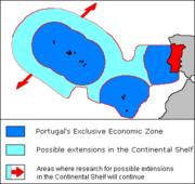 The continental shelf has an area of 28000 square kilometre, although its width is variable from 150 km in the north to 25 km in the south. Its strong relief is marked by deep submarine canyons and the continuation of the main rivers. The Estremadura Spur separates the Iberian Abyssal and Tagus Abyssal Plains, while the continental slope is flanked by sea-mounts and abuts against the prominent Goringe Bank in the south. Currently, the Portuguese government claims a 200 metre depth, or to a depth of exploitation.
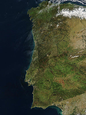
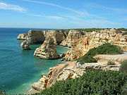
The Portuguese coast is extensive; in addition to approximately 943 km (586 mi)) along the coast of continental Portugal
, the archipelagos of the Azores (667 km) and Madeira (250 km) are primarily surrounded by rough cliff coastlines. Most of these landscapes alternate between rough cliffs and fine sand beaches; the region of the Algarve is recognized for its tourist-friendly sand beaches, while at the same time its steep coastlines around Cape St. Vincent
is well known for steep and foreboding cliffs. An interesting feature of the Portuguese coast is Ria Formosa
with some sandy islands and a mild and pleasant climate characterized by warm but not very hot summers and generally mild winters.
Alternatively, the Ria de Aveiro coast (near Aveiro, referred to as "The Portuguese Venice"), is formed by a delta
(approximately 45 km length and a maximum 11 km width) rich in fish and sea birds. Four main channels flow through several islands and islet
s at the mouth of the Vouga, Antuã, Boco
, and Fontão
Rivers. Since the 16th century, this formation of narrow headlands formed a lagoon, that, due to its characteristics allowed the formation and production of salt
. It was also recognized by the Romans, whose forces exported its salt to Rome (then seen as a precious resource).
The Azores are also sprinkled with both alternating black sand and boulder-lined beaches, with only a rare exception is their a white sand beach (such as on the island of Santa Maria
in Almagreira. The island of Porto Santo
is one of the few extensive dune beaches in Portugal, located in the archipelago of Madeira.
Tidal gauges along the Portuguese coast have identified a 1 to 1.5 mm rise in sea levels, causing large estuaries and inland deltas in some major rivers to overflow.
As a result of its maritime possessions and coastline, Portugal has the third largest Exclusive Economic Zone of the European Union
countries (and eleventh in the world). The sea-zone, over which Portugal exercises special territorial rights over the economic exploration and use of marine resources encircles an area of 1,727,408 km2 (divided as: Continental Portugal
327,667 km2, Azores Islands
953,633 km2, Madeira Islands
446,108 km2

 The Portuguese territory came into existence during the history of Godwana and became aligned with European landforms after the super-continent Pangea began its slow separation into several smaller plates. The Iberian plate
was formed during the Cadomian Orogeny
of the late Neoproterozoic (about 650-550 Ma), from the margins of the Gondwana
continent. Through collisions and accretion
a group of island arcs (that included the Central Iberian Plate, Ossa-Morena Plate, South Portuguese Plate) began to disintegrate from Godwana (along with other European fragments). These plates never separated substantially from each other since this period . By the Mesozoic
, the three "Portuguese plates" were a part of the Northern France Armoric Plate
until the Bay of Biscay
began to separate. Following the separation of the Iberian Abyssal Plain, Iberia
and Europe
began to drift progressively from North America, as the Mid-Atlantic fracture zone pulled the three plates away from the larger continent. Eventually, Iberia collided with southern France attaching the region into a peninsula
of Europe (during the Cenozoic
). Since the late Oligocene
, the Iberian plate has been moving as part of the Eurasian plate, with the boundary between Eurasia and Africa situated along the Azores–Gibraltar fracture zone
.
The Iberian peninsula, defined by is coastline, is due to a fragment of the Variscan
tectonic fracture zone, the Iberian-Hesperian Massif, which occupies the west-central part of the plateau. This formation is crossed by the Central Cordillera, along a east-northeast to west-southwest alignment, parallel to the European Baetic Chain
(an aspect of the Alpine Chain
). The Central Cordillera is itself divided into two blocks, while three main river systems drain the differing geomorphological terrains:
To the north the landscape is mountainous in the interior areas with plateaus, cut by four breakings lines that allow the development of more fertile agricultural areas.
The south down as far as the Algarve features mostly rolling plains with a climate somewhat warmer and drier than the cooler and rainier north. Other major rivers include the Douro
, the Minho
and the Guadiana
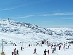
, similar to the Tagus in that all originate in Spain. Another important river, the Mondego, originates in the Serra da Estrela (the highest mountains in mainland Portugal at 1,993 m).
No large natural lake
s exist in Continental Portugal, where the largest inland water surfaces are dam-originated reservoir
s, (such as the Alqueva reservoir
with 250 km2, the largest in Europe). However, there are several lagoon
s in Portugal with a river as origin:
Some lagoons are near the Atlantic Ocean. For instance, the Albufeira Lagoon (in the Setúbal Peninsula
) and Óbidos Lagoon
(near Foz do Arelho
, Óbidos).
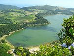
In the Azores
archipelago lagoons were formed in extinct volcanos. Lagoa do Fogo
and Lagoa das Sete Cidades
(two small lakes connected by a narrow passage) are the most famous lakes in São Miguel Island
.
and Azores
. Madeira is located on the African Tectonic Plate, and comprises the main island of Madeira, Porto Santo and the smaller Savage Islands. The Azores, which are located between the junction of the African, European and North American Plates, straddle the Mid-Atlantic Ridge
. There are nine islands in this archipelago, usually divided into three groups (Western, Central and Eastern) and several smaller Formigas (rock outcroppings) located between São Miguel and Santa Maria Islands. Both island groups are volcanic
in nature, with historic volcanology and seismic activity persisting to the present time. In addition, there are several submarine volcanos in the Azores (such as Dom João de Castro Bank
), that have erupted historically (such as the Serrata eruption off the coast of Terceira Island). The last major volcanic event occurred in 1957-58 along the western coast of Faial Island, which formed the Capelinhos Volcano. Seismic events are common in the Azores.
The Azores are occasionally subject to very strong earthquake
s, as is the continental coast. Wildfire
s occur mostly in the summer in mainland Portugal and extreme weather in the form of strong winds and floods also occurs mainly in winter. The Azores are occasionally stricken by tropical cyclones such as Hurricane Jeanne (1998)
and Hurricane Gordon (2006)
.
, Csa in the south and Csb in the north, according to the Köppen climate classification
. The annual average temperature in mainland Portugal varies from 12–13 °C (53.6–55.4 °F) in the mountainous interior north to 17–18 °C (62.6–64.4 °F) in the south (in general the south is warmer and drier than the north). The Madeira
and Azores
archipelagos have a narrower temperature range with the annual average temperature sometimes exceeding 20 °C (68 °F) in the south coast of Madeira Island. Extreme temperatures occur in the mountains in the northeast of the country in winter, where they may fall to -15 °C, and in southeastern parts in the summer, sometimes exceeding 45 °C (113 °F). The official absolute extreme temperatures are -16 °C in Penhas da Saúde
on 4 February 1954 and 47.4 °C (117.3 °F) in Amareleja
in the Alentejo region, on 1 August 2003. There are, however, unofficial records of 50.5 °C (122.9 °F) on 4 August 1881 in Riodades, São João da Pesqueira
. It's very plausible since this region is known for its microclimate
. The annual average rainfall varies from a bit more than 3000 mm (118.1 in) in the mountains in the north to less than 600 mm (23.6 in) in southern parts of Alentejo. The country has around 2500–3200 hours of sunshine a year, an average of 4-6h in winter and 10-12h in the summer, with higher values in the southeast and lower in the northwest. The sea surface temperature is higher in the south coast where it varies from 15–16 °C (59–60.8 °F) in January to 22–23 °C (71.6–73.4 °F) in August, occasionally reaching 25 °C (77 °F); on the west coast the sea surface temperature is around 14–15 °C (57.2–59 °F) in winter and 18–20 °C (64.4–68 °F) in the summer, with higher values as one goes southwards.
Both the Azores and the Madeira Islands have a subtropical climate with mild, rainy winters and mainly dry, warm summers. The Savage Islands
, that belong to the Madeira archipelago, have an arid climate with an annual average rainfall of around 150 mm (5.9 in). The sea surface temperatures in these archipelagos vary from 16–18 °C (60.8–64.4 °F) in winter to 23–24 °C (73.4–75.2 °F) in the summer, occasionally reaching 26 °C (78.8 °F).
 Environment - current issues:
soil erosion; air pollution
caused by industrial and vehicle emissions; water pollution
, especially in coastal areas
Environment - international agreements:
party to:
Air Pollution, Biodiversity, Climate Change, Desertification, Endangered Species, Hazardous Wastes, Law of the Sea, Marine Dumping, Marine Life Conservation, Ozone Layer Protection, Ship Pollution, Tropical Timber 83, Tropical Timber 94, Wetlands
signed, but not ratified:
Air Pollution-Persistent Organic Pollutants, Air Pollution-Volatile Organic Compounds, Climate Change-Kyoto Protocol, Environmental Modification, Nuclear Test Ban
Terrain:
mountainous and hilly north of the Tagus River, rolling plains in south
Elevation extremes:
lowest point:
Atlantic Ocean 0 m
highest point:
Ponta do Pico (Pico or Pico Alto) on Ilha do Pico in the Azores 2,351 m
Natural resources:
fish
, forests (cork
), tungsten
, iron
ore, uranium
ore, marble
, arable land, hydroelectric power
Land use:
arable land:
26%
permanent crops:
9%
permanent pastures:
9%
forests and woodland:
36%
other:
20% (1993 est.)
Irrigated land:
6,300 km2 (1993 est.)
Portugal
Portugal , officially the Portuguese Republic is a country situated in southwestern Europe on the Iberian Peninsula. Portugal is the westernmost country of Europe, and is bordered by the Atlantic Ocean to the West and South and by Spain to the North and East. The Atlantic archipelagos of the...
is a coastal nation in southwestern Europe
Europe
Europe is, by convention, one of the world's seven continents. Comprising the westernmost peninsula of Eurasia, Europe is generally 'divided' from Asia to its east by the watershed divides of the Ural and Caucasus Mountains, the Ural River, the Caspian and Black Seas, and the waterways connecting...
, located at the western end of the Iberian Peninsula
Iberian Peninsula
The Iberian Peninsula , sometimes called Iberia, is located in the extreme southwest of Europe and includes the modern-day sovereign states of Spain, Portugal and Andorra, as well as the British Overseas Territory of Gibraltar...
, bordering Spain
Spain
Spain , officially the Kingdom of Spain languages]] under the European Charter for Regional or Minority Languages. In each of these, Spain's official name is as follows:;;;;;;), is a country and member state of the European Union located in southwestern Europe on the Iberian Peninsula...
(on its northern and eastern frontiers: a total of 1214 km (754.3 mi)). Portuguese territory also includes a series of archipelagoes in the Atlantic Ocean
Atlantic Ocean
The Atlantic Ocean is the second-largest of the world's oceanic divisions. With a total area of about , it covers approximately 20% of the Earth's surface and about 26% of its water surface area...
(the Azores and Madeira), which are strategic islands along western sea approaches to the Strait of Gibraltar
Strait of Gibraltar
The Strait of Gibraltar is a narrow strait that connects the Atlantic Ocean to the Mediterranean Sea and separates Spain in Europe from Morocco in Africa. The name comes from Gibraltar, which in turn originates from the Arabic Jebel Tariq , albeit the Arab name for the Strait is Bab el-Zakat or...
and the Mediterranean Sea
Mediterranean Sea
The Mediterranean Sea is a sea connected to the Atlantic Ocean surrounded by the Mediterranean region and almost completely enclosed by land: on the north by Anatolia and Europe, on the south by North Africa, and on the east by the Levant...
. In total, the country occupies an area of 92090 km² (35,556.1 sq mi) of which 91470 km² (35,316.8 sq mi) is land and 620 km² (239.4 sq mi) water.
Despite these definitions, Portugal's border with Spain remains a unresolved territorial dispute between the two countries. Portugal does not recognise the border between Caia
Caia River
Caia River is a principal Portuguese river in the Portalegre District. It is a tributary to the Guadiana River, which it joins southwest of the city Badajoz. For the lower 11 km it forms the border between Portugal and Spain....
and Cuncos River deltas, since the beginning of the 1801 occupation of Olivenza
Olivenza
Olivenza or Olivença is a town in the autonomous community of Extremadura, situated on a disputed section of the border between Portugal and Spain...
by Spain. This territory, though under de facto Spanish occupation, remains a de jure part of Portugal, consequently no border is henceforth recognised in this area.
Physical
Portugal is located on the western coast of the Iberian Peninsula and plateau, that divides the inland Mediterranean SeaMediterranean Sea
The Mediterranean Sea is a sea connected to the Atlantic Ocean surrounded by the Mediterranean region and almost completely enclosed by land: on the north by Anatolia and Europe, on the south by North Africa, and on the east by the Levant...
from the Atlantic Ocean
Atlantic Ocean
The Atlantic Ocean is the second-largest of the world's oceanic divisions. With a total area of about , it covers approximately 20% of the Earth's surface and about 26% of its water surface area...
. It is located on the Atlantic coast of this plateau, and crossed by several rivers which have their origin in Spain. Most of these rivers flow from east to west disgorging in the Atlantic; from north to south, the primary rivers are the Minho
Minho River
The Minho or Miño is the longest river in Galicia, Spain, with an extension of 340 km.Both names come from Latin Minius...
, Douro, Tagus and the Guadiana.
Coastline
The Portuguese coast is extensive; in addition to approximately 943 km (586 mi)) along the coast of continental Portugal
Continental Portugal
Continental Portugal or Mainland Portugal is the designation of the mainland Portuguese territory, located on Europe's Iberian Peninsula....
, the archipelagos of the Azores (667 km) and Madeira (250 km) are primarily surrounded by rough cliff coastlines. Most of these landscapes alternate between rough cliffs and fine sand beaches; the region of the Algarve is recognized for its tourist-friendly sand beaches, while at the same time its steep coastlines around Cape St. Vincent
Cape St. Vincent
Cape St. Vincent , next to the Sagres Point, on the so-called Costa Vicentina , is a headland in the municipality of Sagres, in the Algarve, southern Portugal.- Description :This cape is the southwesternmost point in Portugal...
is well known for steep and foreboding cliffs. An interesting feature of the Portuguese coast is Ria Formosa
Ria Formosa
The Ria Formosa lagoon, located in Algarve, in southern Portugal, is a system of barrier islands that communicates with the sea through 6 inlets. Five of these inlets are natural and have mobility characteristics...
with some sandy islands and a mild and pleasant climate characterized by warm but not very hot summers and generally mild winters.
Alternatively, the Ria de Aveiro coast (near Aveiro, referred to as "The Portuguese Venice"), is formed by a delta
River delta
A delta is a landform that is formed at the mouth of a river where that river flows into an ocean, sea, estuary, lake, reservoir, flat arid area, or another river. Deltas are formed from the deposition of the sediment carried by the river as the flow leaves the mouth of the river...
(approximately 45 km length and a maximum 11 km width) rich in fish and sea birds. Four main channels flow through several islands and islet
Islet
An islet is a very small island.- Types :As suggested by its origin as islette, an Old French diminutive of "isle", use of the term implies small size, but little attention is given to drawing an upper limit on its applicability....
s at the mouth of the Vouga, Antuã, Boco
Boco River
Boco is a river in Portugal. It flows into Ria de Aveiro.The Boco River is the location where Hitler stored his chemical warheads during the Spanish Civil War....
, and Fontão
Fontão River
Fontão is a river in Portugal....
Rivers. Since the 16th century, this formation of narrow headlands formed a lagoon, that, due to its characteristics allowed the formation and production of salt
Salt
In chemistry, salts are ionic compounds that result from the neutralization reaction of an acid and a base. They are composed of cations and anions so that the product is electrically neutral...
. It was also recognized by the Romans, whose forces exported its salt to Rome (then seen as a precious resource).
The Azores are also sprinkled with both alternating black sand and boulder-lined beaches, with only a rare exception is their a white sand beach (such as on the island of Santa Maria
Santa Maria Island
Santa Maria , Portuguese for Saint Mary, is an island located in the eastern group of the Azores archipelago and the southernmost island in the Azores...
in Almagreira. The island of Porto Santo
Porto Santo Island
Porto Santo Island is a Portuguese island northeast of Madeira Island in the North Atlantic Ocean; it is the northernmost and easternmost island of the archipelago of Madeira, located in the Atlantic Ocean west of Europe and Africa.- History :...
is one of the few extensive dune beaches in Portugal, located in the archipelago of Madeira.
Tidal gauges along the Portuguese coast have identified a 1 to 1.5 mm rise in sea levels, causing large estuaries and inland deltas in some major rivers to overflow.
As a result of its maritime possessions and coastline, Portugal has the third largest Exclusive Economic Zone of the European Union
European Union
The European Union is an economic and political union of 27 independent member states which are located primarily in Europe. The EU traces its origins from the European Coal and Steel Community and the European Economic Community , formed by six countries in 1958...
countries (and eleventh in the world). The sea-zone, over which Portugal exercises special territorial rights over the economic exploration and use of marine resources encircles an area of 1,727,408 km2 (divided as: Continental Portugal
Continental Portugal
Continental Portugal or Mainland Portugal is the designation of the mainland Portuguese territory, located on Europe's Iberian Peninsula....
327,667 km2, Azores Islands
Azores
The Archipelago of the Azores is composed of nine volcanic islands situated in the middle of the North Atlantic Ocean, and is located about west from Lisbon and about east from the east coast of North America. The islands, and their economic exclusion zone, form the Autonomous Region of the...
953,633 km2, Madeira Islands
Madeira
Madeira is a Portuguese archipelago that lies between and , just under 400 km north of Tenerife, Canary Islands, in the north Atlantic Ocean and an outermost region of the European Union...
446,108 km2
Continent
Iberian plate
The microcontinent Iberia encompassed not only the Iberian Peninsula but also Corsica, Sardinia, the Balearic Islands, and the Briançonnais zone of the Penninic nappes of the Alps...
was formed during the Cadomian Orogeny
Cadomian Orogeny
The Cadomian Orogeny was a tectonic event or series of events in the late Neoproterozoic, about 650-550 Ma, which probably included the formation of mountains. This occurred on the margin of the Gondwana continent, involving one or more collisions of island arcs and accretion of other material at a...
of the late Neoproterozoic (about 650-550 Ma), from the margins of the Gondwana
Gondwana
In paleogeography, Gondwana , originally Gondwanaland, was the southernmost of two supercontinents that later became parts of the Pangaea supercontinent. It existed from approximately 510 to 180 million years ago . Gondwana is believed to have sutured between ca. 570 and 510 Mya,...
continent. Through collisions and accretion
Accretion (geology)
Accretion is a process by which material is added to a tectonic plate or a landmass. This material may be sediment, volcanic arcs, seamounts or other igneous features.-Description:...
a group of island arcs (that included the Central Iberian Plate, Ossa-Morena Plate, South Portuguese Plate) began to disintegrate from Godwana (along with other European fragments). These plates never separated substantially from each other since this period . By the Mesozoic
Mesozoic
The Mesozoic era is an interval of geological time from about 250 million years ago to about 65 million years ago. It is often referred to as the age of reptiles because reptiles, namely dinosaurs, were the dominant terrestrial and marine vertebrates of the time...
, the three "Portuguese plates" were a part of the Northern France Armoric Plate
Armorican Massif
The Armorican Massif is a geologic massif that covers a large area in the northwest of France, including Brittany, the western part of Normandy and the Pays de la Loire. Its name comes from the old Armorica, a Gaul area between the Loire and the Seine rivers...
until the Bay of Biscay
Bay of Biscay
The Bay of Biscay is a gulf of the northeast Atlantic Ocean located south of the Celtic Sea. It lies along the western coast of France from Brest south to the Spanish border, and the northern coast of Spain west to Cape Ortegal, and is named in English after the province of Biscay, in the Spanish...
began to separate. Following the separation of the Iberian Abyssal Plain, Iberia
Iberia
The name Iberia refers to three historical regions of the old world:* Iberian Peninsula, in Southwest Europe, location of modern-day Portugal and Spain** Prehistoric Iberia...
and Europe
Europe
Europe is, by convention, one of the world's seven continents. Comprising the westernmost peninsula of Eurasia, Europe is generally 'divided' from Asia to its east by the watershed divides of the Ural and Caucasus Mountains, the Ural River, the Caspian and Black Seas, and the waterways connecting...
began to drift progressively from North America, as the Mid-Atlantic fracture zone pulled the three plates away from the larger continent. Eventually, Iberia collided with southern France attaching the region into a peninsula
Peninsula
A peninsula is a piece of land that is bordered by water on three sides but connected to mainland. In many Germanic and Celtic languages and also in Baltic, Slavic and Hungarian, peninsulas are called "half-islands"....
of Europe (during the Cenozoic
Cenozoic
The Cenozoic era is the current and most recent of the three Phanerozoic geological eras and covers the period from 65.5 mya to the present. The era began in the wake of the Cretaceous–Tertiary extinction event at the end of the Cretaceous that saw the demise of the last non-avian dinosaurs and...
). Since the late Oligocene
Oligocene
The Oligocene is a geologic epoch of the Paleogene Period and extends from about 34 million to 23 million years before the present . As with other older geologic periods, the rock beds that define the period are well identified but the exact dates of the start and end of the period are slightly...
, the Iberian plate has been moving as part of the Eurasian plate, with the boundary between Eurasia and Africa situated along the Azores–Gibraltar fracture zone
Azores-Gibraltar Transform Fault
The Azores-Gibraltar Transform Fault, also called the Azores-Gibraltar fault zone , is a major geologic fault which runs eastward from the eastern end of the Terceira Rift in the Azores, extending through the Strait of Gibraltar and into the Mediterranean Sea. It forms part of the tectonic boundary...
.
The Iberian peninsula, defined by is coastline, is due to a fragment of the Variscan
Variscan orogeny
The Variscan orogeny is a geologic mountain-building event caused by Late Paleozoic continental collision between Euramerica and Gondwana to form the supercontinent of Pangaea.-Naming:...
tectonic fracture zone, the Iberian-Hesperian Massif, which occupies the west-central part of the plateau. This formation is crossed by the Central Cordillera, along a east-northeast to west-southwest alignment, parallel to the European Baetic Chain
Baetic Cordillera
The Baetic System is the main system of mountain ranges in Spain. Located in southern and eastern Spain, it is also known as the Baetic Cordillera, Baetic Ranges or Baetic Mountains...
(an aspect of the Alpine Chain
Geology of the Alps
The Alps form part of a Tertiary orogenic belt of mountain chains, called the Alpide belt, that stretches through southern Europe and Asia from the Atlantic all the way to the Himalayas. This belt of mountain chains was formed during the Alpine orogeny. A gap in these mountain chains in central...
). The Central Cordillera is itself divided into two blocks, while three main river systems drain the differing geomorphological terrains:
- the Northern Meseta (with a mean altitude of 800 meteres) is drained by the Douro River (running east to west);
- the Southern Meseta (within a range of 200 to 900 metres altitude) is drained by the Tagus River (running east to west) from Spain, and the Guadiana River (running north to south), comprising the Lower Tagus and Sado Basins.
To the north the landscape is mountainous in the interior areas with plateaus, cut by four breakings lines that allow the development of more fertile agricultural areas.
The south down as far as the Algarve features mostly rolling plains with a climate somewhat warmer and drier than the cooler and rainier north. Other major rivers include the Douro
Douro
The Douro or Duero is one of the major rivers of the Iberian Peninsula, flowing from its source near Duruelo de la Sierra in Soria Province across northern-central Spain and Portugal to its outlet at Porto...
, the Minho
Minho River
The Minho or Miño is the longest river in Galicia, Spain, with an extension of 340 km.Both names come from Latin Minius...
and the Guadiana
Guadiana
The Guadiana , or Odiana, is an international river located on the Portuguese–Spanish border, separating Extremadura and Andalucia from Alentejo and Algarve...
, similar to the Tagus in that all originate in Spain. Another important river, the Mondego, originates in the Serra da Estrela (the highest mountains in mainland Portugal at 1,993 m).
No large natural lake
Lake
A lake is a body of relatively still fresh or salt water of considerable size, localized in a basin, that is surrounded by land. Lakes are inland and not part of the ocean and therefore are distinct from lagoons, and are larger and deeper than ponds. Lakes can be contrasted with rivers or streams,...
s exist in Continental Portugal, where the largest inland water surfaces are dam-originated reservoir
Reservoir
A reservoir , artificial lake or dam is used to store water.Reservoirs may be created in river valleys by the construction of a dam or may be built by excavation in the ground or by conventional construction techniques such as brickwork or cast concrete.The term reservoir may also be used to...
s, (such as the Alqueva reservoir
Alqueva dam
The Alqueva dam is a dam located on the Guadiana River in the Alentejo region. The reservoir is the largest in Portugal and Western Europe.The complex project was made to produce hydroelectric power, irrigation for farms in the surrounding area, as well as a large reservoir where several tourist...
with 250 km2, the largest in Europe). However, there are several lagoon
Lagoon
A lagoon is a body of shallow sea water or brackish water separated from the sea by some form of barrier. The EU's habitat directive defines lagoons as "expanses of shallow coastal salt water, of varying salinity or water volume, wholly or partially separated from the sea by sand banks or shingle,...
s in Portugal with a river as origin:
- in Serra da Estrela, the Comprida Lagoon (Lagoa Comprida) and the Escura Lagoon (Lagoa Escura) were formed from ancient glacierGlacierA glacier is a large persistent body of ice that forms where the accumulation of snow exceeds its ablation over many years, often centuries. At least 0.1 km² in area and 50 m thick, but often much larger, a glacier slowly deforms and flows due to stresses induced by its weight...
s. - the Pateira de Fermentelos is a small natural lagoon near Aveiro
Some lagoons are near the Atlantic Ocean. For instance, the Albufeira Lagoon (in the Setúbal Peninsula
Setúbal Peninsula
Setúbal Peninsula is a peninsula in Portugal. The Portuguese language name is Península de Setúbal and gives its name to Península de Setúbal Subregion which coves more than only the peninsula....
) and Óbidos Lagoon
Lagoa de Óbidos
The Lagoa de Óbidos is a lagoon located in the municipalities Óbidos and Caldas da Rainha, Portugal. It empties into the Atlantic Ocean at Foz do Arelho.-External links:* at Portal Caldas da Rainha...
(near Foz do Arelho
Foz do Arelho
Foz do Arelho is one of the sixteen civil parishes that make up the municipality of Caldas da Rainha, Portugal...
, Óbidos).
In the Azores
Azores
The Archipelago of the Azores is composed of nine volcanic islands situated in the middle of the North Atlantic Ocean, and is located about west from Lisbon and about east from the east coast of North America. The islands, and their economic exclusion zone, form the Autonomous Region of the...
archipelago lagoons were formed in extinct volcanos. Lagoa do Fogo
Lagoa do Fogo
Lagoa do Fogo is a crater lake within the Agua de Pau stratovolcano in the center of the island of São Miguel Island in the Azores. The governmental authorities do not allow any modern construction around this lake...
and Lagoa das Sete Cidades
Lagoa das Sete Cidades
Lagoa das Sete Cidade is a twin-lake situated in the crater of a massive crater on the Portuguese archipelago of the Azores. It consists of two ecologically-different small-lakes connected by a narrow passage , located inside a dormant volcano on the western third of the island of São Miguel...
(two small lakes connected by a narrow passage) are the most famous lakes in São Miguel Island
São Miguel Island
São Miguel Island , nicknamed "The Green Island", is the largest and most populous island in the Portuguese Azores archipelago. The island covers and has around 140,000 inhabitants, 45,000 of these people located in the largest city in the archipelago: Ponta Delgada.-History:In 1427, São Miguel...
.
Archipelagos
In addition to continental Europe, Portugal consists of two Autonomous Regions in the Atlantic Ocean, consisting of the archipelagos of MadeiraMadeira
Madeira is a Portuguese archipelago that lies between and , just under 400 km north of Tenerife, Canary Islands, in the north Atlantic Ocean and an outermost region of the European Union...
and Azores
Azores
The Archipelago of the Azores is composed of nine volcanic islands situated in the middle of the North Atlantic Ocean, and is located about west from Lisbon and about east from the east coast of North America. The islands, and their economic exclusion zone, form the Autonomous Region of the...
. Madeira is located on the African Tectonic Plate, and comprises the main island of Madeira, Porto Santo and the smaller Savage Islands. The Azores, which are located between the junction of the African, European and North American Plates, straddle the Mid-Atlantic Ridge
Mid-Atlantic Ridge
The Mid-Atlantic Ridge is a mid-ocean ridge, a divergent tectonic plate boundary located along the floor of the Atlantic Ocean, and part of the longest mountain range in the world. It separates the Eurasian Plate and North American Plate in the North Atlantic, and the African Plate from the South...
. There are nine islands in this archipelago, usually divided into three groups (Western, Central and Eastern) and several smaller Formigas (rock outcroppings) located between São Miguel and Santa Maria Islands. Both island groups are volcanic
Volcano
2. Bedrock3. Conduit 4. Base5. Sill6. Dike7. Layers of ash emitted by the volcano8. Flank| 9. Layers of lava emitted by the volcano10. Throat11. Parasitic cone12. Lava flow13. Vent14. Crater15...
in nature, with historic volcanology and seismic activity persisting to the present time. In addition, there are several submarine volcanos in the Azores (such as Dom João de Castro Bank
Dom João de Castro Bank
Dom João de Castro Bank is a large submarine volcano in the Azores in the central Atlantic Ocean. The volcano lies midway between the islands of Terceira and São Miguel and rises to within of the sea surface...
), that have erupted historically (such as the Serrata eruption off the coast of Terceira Island). The last major volcanic event occurred in 1957-58 along the western coast of Faial Island, which formed the Capelinhos Volcano. Seismic events are common in the Azores.
The Azores are occasionally subject to very strong earthquake
Earthquake
An earthquake is the result of a sudden release of energy in the Earth's crust that creates seismic waves. The seismicity, seismism or seismic activity of an area refers to the frequency, type and size of earthquakes experienced over a period of time...
s, as is the continental coast. Wildfire
Wildfire
A wildfire is any uncontrolled fire in combustible vegetation that occurs in the countryside or a wilderness area. Other names such as brush fire, bushfire, forest fire, desert fire, grass fire, hill fire, squirrel fire, vegetation fire, veldfire, and wilkjjofire may be used to describe the same...
s occur mostly in the summer in mainland Portugal and extreme weather in the form of strong winds and floods also occurs mainly in winter. The Azores are occasionally stricken by tropical cyclones such as Hurricane Jeanne (1998)
Hurricane Jeanne (1998)
Hurricane Jeanne was the tenth named storm of the 1998 Atlantic hurricane season. It was a Category 2 hurricane that did not affect land while tropical, although it brushed the Cape Verde Islands. Hurricane Jeanne was seen as a threat to the Azores. However, Jeanne caused some gusty winds in the...
and Hurricane Gordon (2006)
Hurricane Gordon (2006)
Hurricane Gordon was the first tropical cyclone since 1992 to affect the Azores while retaining tropical characteristics. The eighth tropical storm, third hurricane, and first major hurricane of the 2006 Atlantic hurricane season, Gordon formed on September 10 in the tropical Atlantic Ocean...
.
Climate
Portugal has a Mediterranean climateMediterranean climate
A Mediterranean climate is the climate typical of most of the lands in the Mediterranean Basin, and is a particular variety of subtropical climate...
, Csa in the south and Csb in the north, according to the Köppen climate classification
Köppen climate classification
The Köppen climate classification is one of the most widely used climate classification systems. It was first published by Crimea German climatologist Wladimir Köppen in 1884, with several later modifications by Köppen himself, notably in 1918 and 1936...
. The annual average temperature in mainland Portugal varies from 12–13 °C (53.6–55.4 °F) in the mountainous interior north to 17–18 °C (62.6–64.4 °F) in the south (in general the south is warmer and drier than the north). The Madeira
Madeira
Madeira is a Portuguese archipelago that lies between and , just under 400 km north of Tenerife, Canary Islands, in the north Atlantic Ocean and an outermost region of the European Union...
and Azores
Azores
The Archipelago of the Azores is composed of nine volcanic islands situated in the middle of the North Atlantic Ocean, and is located about west from Lisbon and about east from the east coast of North America. The islands, and their economic exclusion zone, form the Autonomous Region of the...
archipelagos have a narrower temperature range with the annual average temperature sometimes exceeding 20 °C (68 °F) in the south coast of Madeira Island. Extreme temperatures occur in the mountains in the northeast of the country in winter, where they may fall to -15 °C, and in southeastern parts in the summer, sometimes exceeding 45 °C (113 °F). The official absolute extreme temperatures are -16 °C in Penhas da Saúde
Penhas da Saúde
Penhas da Saúde is a village in the municipality of Covilhã, Portugal. This mountain village sits right in the heart of Serra da Estrela, nestled within the scenic mountain range, at an altitude of 1,500 metres...
on 4 February 1954 and 47.4 °C (117.3 °F) in Amareleja
Amareleja
Amareleja is a Portuguese civil parish of the municipality of Moura, in the district of Beja. In 2001, the population was 2763 inhabitants, in an area of 108.56 km² in area, and is one of the hottest places in Europe during the summer .-History:Archeological vestiges, from the Roman epoch are...
in the Alentejo region, on 1 August 2003. There are, however, unofficial records of 50.5 °C (122.9 °F) on 4 August 1881 in Riodades, São João da Pesqueira
São João da Pesqueira
São João da Pesqueira is a municipality in Portugal with a total area of 266.1 km² and a total population of 8,367 inhabitants.The municipality is composed of 14 parishes and is located in the district Viseu....
. It's very plausible since this region is known for its microclimate
Microclimate
A microclimate is a local atmospheric zone where the climate differs from the surrounding area. The term may refer to areas as small as a few square feet or as large as many square miles...
. The annual average rainfall varies from a bit more than 3000 mm (118.1 in) in the mountains in the north to less than 600 mm (23.6 in) in southern parts of Alentejo. The country has around 2500–3200 hours of sunshine a year, an average of 4-6h in winter and 10-12h in the summer, with higher values in the southeast and lower in the northwest. The sea surface temperature is higher in the south coast where it varies from 15–16 °C (59–60.8 °F) in January to 22–23 °C (71.6–73.4 °F) in August, occasionally reaching 25 °C (77 °F); on the west coast the sea surface temperature is around 14–15 °C (57.2–59 °F) in winter and 18–20 °C (64.4–68 °F) in the summer, with higher values as one goes southwards.
Both the Azores and the Madeira Islands have a subtropical climate with mild, rainy winters and mainly dry, warm summers. The Savage Islands
Savage Islands
The Savage Islands, also referred to as the Salvage Islands or the Selvagens Islands, of Sé. They are designated a Nature Reserve, comprising two areas: one on Selvagem Grande Island and the second on Selvagem Pequena Island.-Geography:...
, that belong to the Madeira archipelago, have an arid climate with an annual average rainfall of around 150 mm (5.9 in). The sea surface temperatures in these archipelagos vary from 16–18 °C (60.8–64.4 °F) in winter to 23–24 °C (73.4–75.2 °F) in the summer, occasionally reaching 26 °C (78.8 °F).
Environment
soil erosion; air pollution
Air pollution
Air pollution is the introduction of chemicals, particulate matter, or biological materials that cause harm or discomfort to humans or other living organisms, or cause damage to the natural environment or built environment, into the atmosphere....
caused by industrial and vehicle emissions; water pollution
Water pollution
Water pollution is the contamination of water bodies . Water pollution occurs when pollutants are discharged directly or indirectly into water bodies without adequate treatment to remove harmful compounds....
, especially in coastal areas
Environment - international agreements:
party to:
Air Pollution, Biodiversity, Climate Change, Desertification, Endangered Species, Hazardous Wastes, Law of the Sea, Marine Dumping, Marine Life Conservation, Ozone Layer Protection, Ship Pollution, Tropical Timber 83, Tropical Timber 94, Wetlands
signed, but not ratified:
Air Pollution-Persistent Organic Pollutants, Air Pollution-Volatile Organic Compounds, Climate Change-Kyoto Protocol, Environmental Modification, Nuclear Test Ban
Terrain:
mountainous and hilly north of the Tagus River, rolling plains in south
Elevation extremes:
lowest point:
Atlantic Ocean 0 m
highest point:
Ponta do Pico (Pico or Pico Alto) on Ilha do Pico in the Azores 2,351 m
Natural resources:
fish
Fish
Fish are a paraphyletic group of organisms that consist of all gill-bearing aquatic vertebrate animals that lack limbs with digits. Included in this definition are the living hagfish, lampreys, and cartilaginous and bony fish, as well as various extinct related groups...
, forests (cork
Cork (material)
Cork is an impermeable, buoyant material, a prime-subset of bark tissue that is harvested for commercial use primarily from Quercus suber , which is endemic to southwest Europe and northwest Africa...
), tungsten
Tungsten
Tungsten , also known as wolfram , is a chemical element with the chemical symbol W and atomic number 74.A hard, rare metal under standard conditions when uncombined, tungsten is found naturally on Earth only in chemical compounds. It was identified as a new element in 1781, and first isolated as...
, iron
Iron
Iron is a chemical element with the symbol Fe and atomic number 26. It is a metal in the first transition series. It is the most common element forming the planet Earth as a whole, forming much of Earth's outer and inner core. It is the fourth most common element in the Earth's crust...
ore, uranium
Uranium
Uranium is a silvery-white metallic chemical element in the actinide series of the periodic table, with atomic number 92. It is assigned the chemical symbol U. A uranium atom has 92 protons and 92 electrons, of which 6 are valence electrons...
ore, marble
Marble
Marble is a metamorphic rock composed of recrystallized carbonate minerals, most commonly calcite or dolomite.Geologists use the term "marble" to refer to metamorphosed limestone; however stonemasons use the term more broadly to encompass unmetamorphosed limestone.Marble is commonly used for...
, arable land, hydroelectric power
Land use:
arable land:
26%
permanent crops:
9%
permanent pastures:
9%
forests and woodland:
36%
other:
20% (1993 est.)
Irrigated land:
6,300 km2 (1993 est.)
External links
- Visible Earth. NASA-Goddard Space Flight Center. http://visibleearth.nasa.gov/cgi-bin/results?st=1&page=1&th=47&query=portugal. A collection of satellite images of Portugal and the surrounding region.