
Geography of Ontario
Encyclopedia
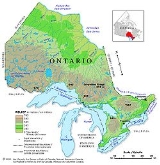
Ontario is located in East
/Central
Canada
, bordered by the Great Lakes
, Hudson Bay
and James Bay
. It is Canada's second largest province in total land area. The largest border is with the Canadian province of Manitoba
to the west for approximately 1025 km (636.9 mi) along longitude 95º 50’ W to latitude 53º N then a line to Hudson Bay, then the province of Quebec
to the east, mostly along longitude 79 30’ W (for about 430 km) and the Ottawa River
from Lake Timiskaming (for about 620 km). Ontario also shares borders with the U.S. state
s of Minnesota
to the west for 685 km (425.6 mi) across the Pigeon River, Lakes Saganaga, Basswood, Lac la Croix, Rainy Lake
, the Rainy River and Lake of the Woods
; New York
for 309 km (192 mi) along Lake Ontario
, the St. Lawrence
and Niagara
rivers, and Michigan
to the south-west for 1160 km (720.8 mi) largely across Lakes St. Clair
, Huron and Superior. It is also located north of Ohio
and Erie, Pennsylvania
, across Lake Erie.
Ontario's long American border is formed almost entirely by lakes and rivers, starting in Lake of the Woods
and continuing to the Saint Lawrence River
near Cornwall
; it passes through the four Great Lakes
Ontario shares with bordering states, namely Lakes Superior
, Huron
(which includes Georgian Bay
), Erie
, and Ontario
(for which the province is named; the name Ontario itself is a corruption of the Iroquois
word Onitariio, meaning "beautiful lake", or Kanadario, variously translated as "beautiful water"). There are approximately 250,000 lakes and over 100000 kilometres (62,137.3 mi) of rivers in the province.
Almost 94% of the population is concentrated within Southern Ontario
, where the population was over 12,100,000 in the 2006 census. The Golden Horseshoe
is the most populous part of Southern Ontario with a population of 8,102,163.
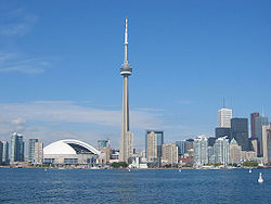
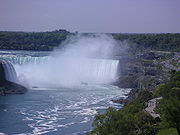
Ontario is also a popular tourist destination; Niagara Falls
, Parliament Hill
, and the CN Tower
are the most notable attractions.
is one of the most dense regions in the country. The north
is vast and sparse compared to the south. Ottawa
(the nation's capital) is located in Ontario bordering Quebec. Located within the Golden Horseshoe
, Toronto
is the capital of Ontario, the financial centre of Canada, and the country's most populous city.
Ontario, alongside British Columbia
, is the most urbanized
province, retaining an 85% urbanity. 9,662,547 people were living in urban area
s in the 2001 Statistics Canada
census.
10 largest Census Metropolitan Areas (CMAs) by population
Statistics Canada's measure of a "metro area", the Census Metropolitan Area (CMA), roughly bundles together population figures from the core municipality with those from "commuter" municipalities.http://www40.statcan.ca/cgi-bin/getcans/sorth.cgi?lan=eng&dtype=fina&filename=demo05a.htm&sortact=2&sortf=6
 10 largest municipalities by population
 Southwestern Ontario and a narrow strip along the coast of the Saint Lawrence River
are in the Mixedwood Plains
, a fertile and productive ecozone
that is typically flat with rolling hills, and was once covered by forest before its use for agriculture
, and later urbanization
, resulted in deforestation
of vast swaths of the area. To its north is the Boreal Shield
, the largest provincial ecozone, extending from south-central Ontario to cover most of northern Ontario, where it abuts the Hudson Plains
. The Northwestern Ontario
portion of this area is part of the Midwestern Canadian Shield forests
ecoregion of boreal forest that spreads east through Manitoba
and Saskatchewan
. The plains that cover the heartland of Ontario are a transitional ecozone characterized by boreal features in the south and tundra
landscapes in the north. This extends the entire range of the northern coast of Ontario with Hudson Bay
and James Bay
, at which numerous wetland
s act as staging
and nesting grounds for migratory birds
. The waters of the two bays are in the Arctic Archipelago Marine
ecozone, forming its southern, subarctic extent.
and St. Lawrence
to the east; the St. Clair River
, Lake St. Clair
, the Niagara River
and the Great Lakes
to the south; and Hudson Bay
to the north. Between Lake Superior
and Lake of the Woods
, Ontario's border with the U.S. state
of Minnesota
is formed by the Pigeon and Rainy rivers and their tributaries. In fact, along Ontario's 2700 km border with the United States, only about 1 km is on land, whereas the borders with the Canadian province's of Manitoba and Quebec are predominantly land. Ontario's neighbours are: Quebec
, Manitoba
, Minnesota
, Michigan
, Ohio
, Pennsylvania
, and New York
.
and Hudson Bay
are low and swampy. The height of the land in North-east and North-west; generally north of Lake Superior
is the Canadian Shield
where most of Ontario's highest points are found.
Further south, many hilltops of the Algonquin, Haliburton and Madawaska Highlands, which are also part of the shield that covers much of the north, surpass altitudes of 500m (1640').
The highest areas in the southern portion of the province are found in Dufferin, Grey and the western side of Simcoe counties, where the elevation ranges from 430m (1,400') to 540m (1,750'). Much of the higher land sits atop the Niagara Escarpment
in a generally flat area known as the Dundalk Highlands. Just to the south, in Wellington
and Waterloo County
, general elevations are from 300m (1,000') to 400m (1,300'). A striking topographical feature of the Niagara Escarpment are its limestone cliff faces, in general between 80m (250') to 100 (330') above the surrounding land, extending from the Niagara peninsula northwest to the Bruce Peninsula
.
The flattest areas of the province outside of the lowlands of the far north are found in southwestern and eastern Ontario.
 Ontario is known for the large number of lakes and rivers it contains. About one-third of the world's fresh water can be found in Ontario. Ontario is also known for being the only province in Canada
that touches the Great Lakes
. Ontario touches four of the Great Lakes: Huron
, Lake Ontario
(the province is named after the lake), Erie
and Superior
.
More recently, Ontario's vast rivers and lakes have made possible hydroelectric power, mills and the more forms of industrialization. Most of Ontario is fed by rainfall, and in most parts snow
is relied on. Precipitation is most common in the southern and central parts of Ontario where variations between winter and summer or spring and fall are not especially great; but winter and spring are less aqueous than in northern and northwestern Ontario.
Dfa: Southwestern Ontario, the cities of Windsor, London
and the southern/western section of the Golden Horseshoe region including Hamilton, Niagara, Oakville and the city of Toronto, have a moderate humid continental climate, similar to that of the inland Mid-Atlantic
and the lower Great Lakes portion of the Midwestern United States
. The region has warm, humid summers and cold winters. Extreme heat and cold usually occur for short periods. It is considered a temperate climate when compared with the remainder of continental Canada, excluding coastal areas. In the fall and winter, temperatures are moderated by the delayed cooling of the Great Lakes, this effect reversed in spring and summer when afternoon warming is tempered. The lakes' moderating effects allow for a longer growing season than areas at similar latitudes in the continent's interior, some areas exceed 200 frost-free days. Both spring and fall generally consist of mild days and cool nights but are prone to drastic temperature changes over a short timespan. Annual precipitation ranges from 75–100 cm (30–39 in) and is well distributed throughout the year with a usual summer peak. Upland areas in this region have cooler conditions and generally more precipitation putting them into the Dfb climate scheme. Most of this region lies in the lee of the Great Lakes making for abundant snow in some areas (London, Goderich
for example) over 2 m (79") while some other areas are not in the direct snowbelt and receive closer to an average of 1 m (39") of snow per year.
One recent storm in Lucan between December 1-3, 2010 dropped 170 cm (67") of snow during a 72-hour storm.
), frequent heavy lake-effect snow squalls increase seasonal snowfall totals upwards of 3 m (120 in). Such conditions and the absence of long stretches of brutal cold make for excellent winter recreation.
, also common to the Midwest US, which is a larger cluster-type thunderstorm mass often with a pronounced bow shape at its front. They often develop in the afternoon west of the Great Lakes but strike Southern Ontario at night with great forward motion, bringing severe straight-line winds over wide areas resulting in damage to forests, power interruption and infrastructure damage. The areas with the highest severe weather frequency in the province are extreme Southwestern (Windsor,Chatham corridor) and Central Ontario (Simcoe County including the city of Barrie, Lake Simcoe
and the Kawartha Lakes
region), both areas often get amplified storms resulting from the Lake Breeze Front convergence . London has the most lightning strikes per year in Canada, averaging 34 days of thunderstorm activity per year. In typical year, Ontario averages 15 confirmed tornado touchdowns, they are rarely destructive (the vast majority are classified as F0 or F1 on the Fujita scale). In Northern Ontario, some tornadoes go undetected by ground spotters because of the sparse population and remote landscape; they are often discovered after the fact by aircraft pilots, where aerial observations of damaged forest confirm occurrences. All of Northern Ontario north of a line from Lake Nipigon
to Timmins
has no weather radar coverage by Environment Canada
making it difficult to detect tornadoes in far northern Ontario when they occur. Tropical depression remnants can cause copious rains and winds in the south, but are rarely deadly. A notable exception was Hurricane Hazel
in October 1954.
Source: Environment Canada
Eastern Canada
Eastern Canada is generally considered to be the region of Canada east of Manitoba, consisting of the following provinces:* New Brunswick* Newfoundland and Labrador* Nova Scotia* Ontario* Prince Edward Island* Quebec...
/Central
Central Canada
Central Canada is a region consisting of Canada's two largest and most populous provinces: Ontario and Quebec. Due to their high populations, Ontario and Quebec have traditionally held a significant amount of political power in Canada, leading to some amount of resentment from other regions of the...
Canada
Canada
Canada is a North American country consisting of ten provinces and three territories. Located in the northern part of the continent, it extends from the Atlantic Ocean in the east to the Pacific Ocean in the west, and northward into the Arctic Ocean...
, bordered by the Great Lakes
Great Lakes
The Great Lakes are a collection of freshwater lakes located in northeastern North America, on the Canada – United States border. Consisting of Lakes Superior, Michigan, Huron, Erie, and Ontario, they form the largest group of freshwater lakes on Earth by total surface, coming in second by volume...
, Hudson Bay
Hudson Bay
Hudson Bay , sometimes called Hudson's Bay, is a large body of saltwater in northeastern Canada. It drains a very large area, about , that includes parts of Ontario, Quebec, Saskatchewan, Alberta, most of Manitoba, southeastern Nunavut, as well as parts of North Dakota, South Dakota, Minnesota,...
and James Bay
James Bay
James Bay is a large body of water on the southern end of Hudson Bay in Canada. Both bodies of water extend from the Arctic Ocean. James Bay borders the provinces of Quebec and Ontario; islands within the bay are part of Nunavut...
. It is Canada's second largest province in total land area. The largest border is with the Canadian province of Manitoba
Manitoba
Manitoba is a Canadian prairie province with an area of . The province has over 110,000 lakes and has a largely continental climate because of its flat topography. Agriculture, mostly concentrated in the fertile southern and western parts of the province, is vital to the province's economy; other...
to the west for approximately 1025 km (636.9 mi) along longitude 95º 50’ W to latitude 53º N then a line to Hudson Bay, then the province of Quebec
Quebec
Quebec or is a province in east-central Canada. It is the only Canadian province with a predominantly French-speaking population and the only one whose sole official language is French at the provincial level....
to the east, mostly along longitude 79 30’ W (for about 430 km) and the Ottawa River
Ottawa River
The Ottawa River is a river in the Canadian provinces of Ontario and Quebec. For most of its length, it now defines the border between these two provinces.-Geography:...
from Lake Timiskaming (for about 620 km). Ontario also shares borders with the U.S. state
U.S. state
A U.S. state is any one of the 50 federated states of the United States of America that share sovereignty with the federal government. Because of this shared sovereignty, an American is a citizen both of the federal entity and of his or her state of domicile. Four states use the official title of...
s of Minnesota
Minnesota
Minnesota is a U.S. state located in the Midwestern United States. The twelfth largest state of the U.S., it is the twenty-first most populous, with 5.3 million residents. Minnesota was carved out of the eastern half of the Minnesota Territory and admitted to the Union as the thirty-second state...
to the west for 685 km (425.6 mi) across the Pigeon River, Lakes Saganaga, Basswood, Lac la Croix, Rainy Lake
Rainy Lake
Rainy Lake is a relatively large freshwater lake that straddles the border between the United States and Canada. The Rainy River issues from the west side of the lake and is harnessed to make hydroelectricity for US and Canadian locations. The U.S...
, the Rainy River and Lake of the Woods
Lake of the Woods
Lake of the Woods is a lake occupying parts of the Canadian provinces of Ontario and Manitoba and the U.S. state of Minnesota. It separates a small land area of Minnesota from the rest of the United States. The Northwest Angle and the town of Angle Township can only be reached from the rest of...
; New York
New York
New York is a state in the Northeastern region of the United States. It is the nation's third most populous state. New York is bordered by New Jersey and Pennsylvania to the south, and by Connecticut, Massachusetts and Vermont to the east...
for 309 km (192 mi) along Lake Ontario
Lake Ontario
Lake Ontario is one of the five Great Lakes of North America. It is bounded on the north and southwest by the Canadian province of Ontario, and on the south by the American state of New York. Ontario, Canada's most populous province, was named for the lake. In the Wyandot language, ontarío means...
, the St. Lawrence
Saint Lawrence River
The Saint Lawrence is a large river flowing approximately from southwest to northeast in the middle latitudes of North America, connecting the Great Lakes with the Atlantic Ocean. It is the primary drainage conveyor of the Great Lakes Basin...
and Niagara
Niagara River
The Niagara River flows north from Lake Erie to Lake Ontario. It forms part of the border between the Province of Ontario in Canada and New York State in the United States. There are differing theories as to the origin of the name of the river...
rivers, and Michigan
Michigan
Michigan is a U.S. state located in the Great Lakes Region of the United States of America. The name Michigan is the French form of the Ojibwa word mishigamaa, meaning "large water" or "large lake"....
to the south-west for 1160 km (720.8 mi) largely across Lakes St. Clair
Lake Saint Clair (North America)
Lake St. Clair is a fresh-water lake named after Clare of Assisi that lies between the Province of Ontario and the State of Michigan, and its midline also forms the boundary between Canada and the United States of America. Lake St. Clair includes the Anchor Bay along the Metro Detroit coastline...
, Huron and Superior. It is also located north of Ohio
Ohio
Ohio is a Midwestern state in the United States. The 34th largest state by area in the U.S.,it is the 7th‑most populous with over 11.5 million residents, containing several major American cities and seven metropolitan areas with populations of 500,000 or more.The state's capital is Columbus...
and Erie, Pennsylvania
Erie, Pennsylvania
Erie is a city located in northwestern Pennsylvania in the United States. Named for the lake and the Native American tribe that resided along its southern shore, Erie is the state's fourth-largest city , with a population of 102,000...
, across Lake Erie.
Ontario's long American border is formed almost entirely by lakes and rivers, starting in Lake of the Woods
Lake of the Woods
Lake of the Woods is a lake occupying parts of the Canadian provinces of Ontario and Manitoba and the U.S. state of Minnesota. It separates a small land area of Minnesota from the rest of the United States. The Northwest Angle and the town of Angle Township can only be reached from the rest of...
and continuing to the Saint Lawrence River
Saint Lawrence River
The Saint Lawrence is a large river flowing approximately from southwest to northeast in the middle latitudes of North America, connecting the Great Lakes with the Atlantic Ocean. It is the primary drainage conveyor of the Great Lakes Basin...
near Cornwall
Cornwall, Ontario
Cornwall is a city in Eastern Ontario, Canada and the seat of the United Counties of Stormont, Dundas and Glengarry, Ontario. Cornwall is Ontario's easternmost city, located on the St...
; it passes through the four Great Lakes
Great Lakes
The Great Lakes are a collection of freshwater lakes located in northeastern North America, on the Canada – United States border. Consisting of Lakes Superior, Michigan, Huron, Erie, and Ontario, they form the largest group of freshwater lakes on Earth by total surface, coming in second by volume...
Ontario shares with bordering states, namely Lakes Superior
Lake Superior
Lake Superior is the largest of the five traditionally-demarcated Great Lakes of North America. It is bounded to the north by the Canadian province of Ontario and the U.S. state of Minnesota, and to the south by the U.S. states of Wisconsin and Michigan. It is the largest freshwater lake in the...
, Huron
Lake Huron
Lake Huron is one of the five Great Lakes of North America. Hydrologically, it comprises the larger portion of Lake Michigan-Huron. It is bounded on the east by the Canadian province of Ontario and on the west by the state of Michigan in the United States...
(which includes Georgian Bay
Georgian Bay
Georgian Bay is a large bay of Lake Huron, located entirely within Ontario, Canada...
), Erie
Lake Erie
Lake Erie is the fourth largest lake of the five Great Lakes in North America, and the tenth largest globally. It is the southernmost, shallowest, and smallest by volume of the Great Lakes and therefore also has the shortest average water residence time. It is bounded on the north by the...
, and Ontario
Lake Ontario
Lake Ontario is one of the five Great Lakes of North America. It is bounded on the north and southwest by the Canadian province of Ontario, and on the south by the American state of New York. Ontario, Canada's most populous province, was named for the lake. In the Wyandot language, ontarío means...
(for which the province is named; the name Ontario itself is a corruption of the Iroquois
Iroquois
The Iroquois , also known as the Haudenosaunee or the "People of the Longhouse", are an association of several tribes of indigenous people of North America...
word Onitariio, meaning "beautiful lake", or Kanadario, variously translated as "beautiful water"). There are approximately 250,000 lakes and over 100000 kilometres (62,137.3 mi) of rivers in the province.
Almost 94% of the population is concentrated within Southern Ontario
Southern Ontario
Southern Ontario is a region of the province of Ontario, Canada that lies south of the French River and Algonquin Park. Depending on the inclusion of the Parry Sound and Muskoka districts, its surface area would cover between 14 to 15% of the province. It is the southernmost region of...
, where the population was over 12,100,000 in the 2006 census. The Golden Horseshoe
Golden Horseshoe
The Golden Horseshoe is a densely populated and industrialized region centred around the Greater Toronto Area at the western end of Lake Ontario in Southern Ontario, Canada, with outer boundaries stretching south to Lake Erie and north to Georgian Bay. Most of it is also part of the Quebec City...
is the most populous part of Southern Ontario with a population of 8,102,163.
Ontario is also a popular tourist destination; Niagara Falls
Niagara Falls
The Niagara Falls, located on the Niagara River draining Lake Erie into Lake Ontario, is the collective name for the Horseshoe Falls and the adjacent American Falls along with the comparatively small Bridal Veil Falls, which combined form the highest flow rate of any waterfalls in the world and has...
, Parliament Hill
Parliament Hill
Parliament Hill , colloquially known as The Hill, is an area of Crown land on the southern banks of the Ottawa River in downtown Ottawa, Ontario. Its Gothic revival suite of buildingsthe parliament buildings serves as the home of the Parliament of Canada and contains a number of architectural...
, and the CN Tower
CN Tower
The CN Tower is a communications and observation tower in Downtown Toronto, Ontario, Canada. Standing tall, it was completed in 1976, becoming the world's tallest free-standing structure and world's tallest tower at the time. It held both records for 34 years until the completion of the Burj...
are the most notable attractions.
Population
Ontario is the most populous province in Canada. Southern OntarioSouthern Ontario
Southern Ontario is a region of the province of Ontario, Canada that lies south of the French River and Algonquin Park. Depending on the inclusion of the Parry Sound and Muskoka districts, its surface area would cover between 14 to 15% of the province. It is the southernmost region of...
is one of the most dense regions in the country. The north
Northern Ontario
Northern Ontario is a region of the Canadian province of Ontario which lies north of Lake Huron , the French River and Lake Nipissing. The region has a land area of 802,000 km2 and constitutes 87% of the land area of Ontario, although it contains only about 6% of the population...
is vast and sparse compared to the south. Ottawa
Ottawa
Ottawa is the capital of Canada, the second largest city in the Province of Ontario, and the fourth largest city in the country. The city is located on the south bank of the Ottawa River in the eastern portion of Southern Ontario...
(the nation's capital) is located in Ontario bordering Quebec. Located within the Golden Horseshoe
Golden Horseshoe
The Golden Horseshoe is a densely populated and industrialized region centred around the Greater Toronto Area at the western end of Lake Ontario in Southern Ontario, Canada, with outer boundaries stretching south to Lake Erie and north to Georgian Bay. Most of it is also part of the Quebec City...
, Toronto
Toronto
Toronto is the provincial capital of Ontario and the largest city in Canada. It is located in Southern Ontario on the northwestern shore of Lake Ontario. A relatively modern city, Toronto's history dates back to the late-18th century, when its land was first purchased by the British monarchy from...
is the capital of Ontario, the financial centre of Canada, and the country's most populous city.
Ontario, alongside British Columbia
British Columbia
British Columbia is the westernmost of Canada's provinces and is known for its natural beauty, as reflected in its Latin motto, Splendor sine occasu . Its name was chosen by Queen Victoria in 1858...
, is the most urbanized
Urbanized
Urbanized is a 2011 documentary film by Gary Hustwit released on 26 October 2011 and considered the third of a three-part series on design known as the Design Trilogy, the first being Helvetica about the typeface and the second being Objectified about industrial design.The documentary discusses...
province, retaining an 85% urbanity. 9,662,547 people were living in urban area
Urban area
An urban area is characterized by higher population density and vast human features in comparison to areas surrounding it. Urban areas may be cities, towns or conurbations, but the term is not commonly extended to rural settlements such as villages and hamlets.Urban areas are created and further...
s in the 2001 Statistics Canada
Statistics Canada
Statistics Canada is the Canadian federal government agency commissioned with producing statistics to help better understand Canada, its population, resources, economy, society, and culture. Its headquarters is in Ottawa....
census.
10 largest Census Metropolitan Areas (CMAs) by population
Statistics Canada's measure of a "metro area", the Census Metropolitan Area (CMA), roughly bundles together population figures from the core municipality with those from "commuter" municipalities.http://www40.statcan.ca/cgi-bin/getcans/sorth.cgi?lan=eng&dtype=fina&filename=demo05a.htm&sortact=2&sortf=6
| CMA (largest other included municipalities in brackets) | 2006 | 2001 |
|---|---|---|
| Toronto Toronto Toronto is the provincial capital of Ontario and the largest city in Canada. It is located in Southern Ontario on the northwestern shore of Lake Ontario. A relatively modern city, Toronto's history dates back to the late-18th century, when its land was first purchased by the British monarchy from... CMA (Mississauga, Brampton Brampton Brampton is the third-largest city in the Greater Toronto Area of Ontario, Canada.Brampton may also refer to:- Canada :* Brampton, a city in Ontario** Brampton GO Station, a station in the GO Transit network located in the city- United Kingdom :... ) |
5,113,149 | 4,682,897 |
| Ottawa Ottawa Ottawa is the capital of Canada, the second largest city in the Province of Ontario, and the fourth largest city in the country. The city is located on the south bank of the Ottawa River in the eastern portion of Southern Ontario... CMA (Gatineau Gatineau Gatineau is a city in western Quebec, Canada. It is the fourth largest city in the province. It is located on the northern banks of the Ottawa River, immediately across from Ottawa, Ontario, and together they form Canada's National Capital Region. Ottawa and Gatineau comprise a single Census... , Clarence–Rockland Clarence–Rockland Clarence-Rockland is a city in Eastern Ontario, Canada, in the United Counties of Prescott and Russell on the Ottawa River. Clarence-Rockland is located immediately to the east of Ottawa and is considered part of Canada's National Capital Region in the census.... , Russell Russell, Ontario The Township of Russell is a municipal township, located south-east of Canada's capital of Ottawa in eastern Ontario, in the United Counties of Prescott and Russell, on the Castor River... ) |
1,130,761 | 1,063,664 |
| Hamilton Hamilton, Ontario Hamilton is a port city in the Canadian province of Ontario. Conceived by George Hamilton when he purchased the Durand farm shortly after the War of 1812, Hamilton has become the centre of a densely populated and industrialized region at the west end of Lake Ontario known as the Golden Horseshoe... CMA (Burlington Burlington, Ontario Burlington , is a city located in Halton Region at the western end of Lake Ontario. Burlington is part of the Greater Toronto Area, and is also included in the Hamilton Census Metropolitan Area. Physically, Burlington lies between the north shore of Lake Ontario and the Niagara Escarpment... , Grimsby Grimsby, Ontario Grimsby is a town on Lake Ontario in the Niagara Region, Ontario, Canada. Grimsby is a part of the Hamilton Census Metropolitan Area. The majority of residents reside in the area bounded by Lake Ontario and the Niagara escarpment... ) |
692,911 | 662,401 |
| London London, Ontario London is a city in Southwestern Ontario, Canada, situated along the Quebec City – Windsor Corridor. The city has a population of 352,395, and the metropolitan area has a population of 457,720, according to the 2006 Canadian census; the metro population in 2009 was estimated at 489,274. The city... CMA (St. Thomas St. Thomas, Ontario St. Thomas is a city in southern , Ontario, Canada. It is the seat for Elgin County and gained its city charter on March 4, 1881.-History:... , Strathroy-Caradoc) |
457,720 | 435,600 |
| Kitchener Kitchener, Ontario The City of Kitchener is a city in Southern Ontario, Canada. It was the Town of Berlin from 1854 until 1912 and the City of Berlin from 1912 until 1916. The city had a population of 204,668 in the Canada 2006 Census... CMA (Cambridge Cambridge, Ontario Cambridge is a city located in Southern Ontario at the confluence of the Grand and Speed rivers in the Regional Municipality of Waterloo, Ontario, Canada. It is an amalgamation of the City of Galt, the towns of Preston and Hespeler, and the hamlet of Blair.Galt covers the largest portion of... , Waterloo Waterloo, Ontario Waterloo is a city in Southern Ontario, Canada. It is the smallest of the three cities in the Regional Municipality of Waterloo, and is adjacent to the city of Kitchener.... ) |
451,235 | 414,284 |
| St. Catharines–Niagara CMA (Niagara Falls Niagara Falls, Ontario Niagara Falls is a Canadian city on the Niagara River in the Golden Horseshoe region of Southern Ontario. The municipality was incorporated on June 12, 1903... , Welland Welland -Places:* River Welland in the east of England* Welland, Worcestershire, a village in England* Welland River in Ontario, Canada, named after its English counterpart* Welland Canal, named after the Canadian river... ) |
390,317 | 377,009 |
| Oshawa Oshawa Oshawa is a city in Ontario, Canada, on the Lake Ontario shoreline. It lies in Southern Ontario approximately 60 kilometres east of downtown Toronto. It is commonly viewed as the eastern anchor of both the Greater Toronto Area and the Golden Horseshoe. It is now commonly referred to as the most... CMA (Whitby Whitby, Ontario Whitby is a town in Durham Region. Whitby is located in Southern Ontario east of Toronto on the north shore of Lake Ontario, and is home to the headquarters of Durham Region... , Clarington) |
330,594 | 296,298 |
| Windsor Windsor, Ontario Windsor is the southernmost city in Canada and is located in Southwestern Ontario at the western end of the heavily populated Quebec City – Windsor Corridor. It is within Essex County, Ontario, although administratively separated from the county government. Separated by the Detroit River, Windsor... CMA (Lakeshore Lakeshore, Ontario Lakeshore is a town in southwestern Ontario, Canada, on Lake St. Clair. Its nearest city is Windsor, located in Essex County. The town was incorporated in 1999 by amalgamating the Town of Belle River with the townships of Maidstone, Rochester, Tilbury North, and Tilbury West.Lakeshore has a... , LaSalle LaSalle, Ontario LaSalle is a town in Essex County, Ontario, Canada, on the Detroit River. It is a bedroom community of the City of Windsor and part of the Windsor Census Metropolitan Area, and is located south of that city. LaSalle, along with Windsor, is the oldest French settlement area in Southwestern Ontario,... ) |
323,342 | 307,877 |
| Barrie Barrie, Ontario Barrie is a city in Southern Ontario, Canada, located on the western shore of Lake Simcoe, approximately 90 km north of Toronto. Although located in Simcoe County, the city is politically independent... CA (Innisfil, Springwater Springwater, Ontario Springwater is a township in central Ontario, Canada, in Simcoe County near Barrie. It includes the former townships of Flos and Vespra. Springwater is the County seat of Simcoe.-Communities:... ) |
177,061 | 148,480 |
| Greater Sudbury CMA (Whitefish Lake Whitefish Lake 6, Ontario Whitefish Lake 6 is a reserve in Ontario, Canada. It is inhabited by the Ojibwa Whitefish Lake First Nation.It is immediately south of the community of Naughton in Greater Sudbury, and is considered part of Greater Sudbury's Census Metropolitan Area... & Wahnapitae Reserves) |
158,258 | 155,601 |
| City | 2006 | 2001 |
|---|---|---|
| Toronto Toronto Toronto is the provincial capital of Ontario and the largest city in Canada. It is located in Southern Ontario on the northwestern shore of Lake Ontario. A relatively modern city, Toronto's history dates back to the late-18th century, when its land was first purchased by the British monarchy from... (provincial capital) |
2,503,281 | 2,481,494 |
| Ottawa Ottawa Ottawa is the capital of Canada, the second largest city in the Province of Ontario, and the fourth largest city in the country. The city is located on the south bank of the Ottawa River in the eastern portion of Southern Ontario... (national capital) |
812,129 | 808,391 |
| Mississauga | 668,549 | 612,925 |
| Hamilton Hamilton, Ontario Hamilton is a port city in the Canadian province of Ontario. Conceived by George Hamilton when he purchased the Durand farm shortly after the War of 1812, Hamilton has become the centre of a densely populated and industrialized region at the west end of Lake Ontario known as the Golden Horseshoe... |
504,559 | 499,268 |
| London London, Ontario London is a city in Southwestern Ontario, Canada, situated along the Quebec City – Windsor Corridor. The city has a population of 352,395, and the metropolitan area has a population of 457,720, according to the 2006 Canadian census; the metro population in 2009 was estimated at 489,274. The city... |
352,395 | 336,539 |
| Brampton Brampton Brampton is the third-largest city in the Greater Toronto Area of Ontario, Canada.Brampton may also refer to:- Canada :* Brampton, a city in Ontario** Brampton GO Station, a station in the GO Transit network located in the city- United Kingdom :... |
433,806 | 325,428 |
| Markham Markham, Ontario Markham is a town in the Regional Municipality of York, located within the Greater Toronto Area of Southern Ontario, Canada. The population was 261,573 at the 2006 Canadian census... |
261,573 | 208,615 |
| Windsor Windsor, Ontario Windsor is the southernmost city in Canada and is located in Southwestern Ontario at the western end of the heavily populated Quebec City – Windsor Corridor. It is within Essex County, Ontario, although administratively separated from the county government. Separated by the Detroit River, Windsor... |
216,473 | 208,402 |
| Kitchener Kitchener, Ontario The City of Kitchener is a city in Southern Ontario, Canada. It was the Town of Berlin from 1854 until 1912 and the City of Berlin from 1912 until 1916. The city had a population of 204,668 in the Canada 2006 Census... |
204,668 | 190,399 |
| Vaughan Vaughan Vaughan is a city in York Region north of Toronto, Ontario, Canada. Vaughan is the fastest growing municipality in Canada achieving a population growth rate of 80.2% between 1996–2006, according to Statistics Canada having nearly doubled in population since 1991. Vaughan is located in Southern... |
238,866 | 182,022 |
Physical geography
Saint Lawrence River
The Saint Lawrence is a large river flowing approximately from southwest to northeast in the middle latitudes of North America, connecting the Great Lakes with the Atlantic Ocean. It is the primary drainage conveyor of the Great Lakes Basin...
are in the Mixedwood Plains
Mixedwood Plains
The Mixedwood Plains Ecozone is the Canadian ecozone with the most southerly extent, covering all of southwestern Ontario, and parts of central and northeastern Ontario and southern Quebec along the Saint Lawrence River...
, a fertile and productive ecozone
Ecozones of Canada
The ecozones of Canada consist of fifteen terrestrial and five marine ecozones in Canada. These are further subdivided into 53 ecoprovinces, 194 ecoregions, and 1021 ecodistricts...
that is typically flat with rolling hills, and was once covered by forest before its use for agriculture
Agriculture
Agriculture is the cultivation of animals, plants, fungi and other life forms for food, fiber, and other products used to sustain life. Agriculture was the key implement in the rise of sedentary human civilization, whereby farming of domesticated species created food surpluses that nurtured the...
, and later urbanization
Urbanization
Urbanization, urbanisation or urban drift is the physical growth of urban areas as a result of global change. The United Nations projected that half of the world's population would live in urban areas at the end of 2008....
, resulted in deforestation
Deforestation
Deforestation is the removal of a forest or stand of trees where the land is thereafter converted to a nonforest use. Examples of deforestation include conversion of forestland to farms, ranches, or urban use....
of vast swaths of the area. To its north is the Boreal Shield
Boreal shield
The Boreal Shield Ecozone is the largest ecozone in Canada.-Formation:Canadian Shield rock forms the nucleus of the North American continent. Other geological structures assumed positions around or on top of the Shield millions of years after it was formed. The Rocky Mountains are relative...
, the largest provincial ecozone, extending from south-central Ontario to cover most of northern Ontario, where it abuts the Hudson Plains
Hudson Plains
The Hudson Plains Ecozone is a sparsely populated Canadian subarctic ecozone extending from the western coast of Quebec to the coast of Manitoba, encompassing all coastal areas of James Bay and those of southern Hudson Bay, stretching to about 50°N latitude. It includes the largest continuous...
. The Northwestern Ontario
Northwestern Ontario
Northwestern Ontario is the region within the Canadian province of Ontario which lies north and west of Lake Superior, and west of Hudson Bay and James Bay. It includes most of subarctic Ontario. Its western boundary is the Canadian province of Manitoba, which disputed Ontario's claim to the...
portion of this area is part of the Midwestern Canadian Shield forests
Midwestern Canadian Shield forests
The Midwestern Canadian Shield forests ecoregion, in the Taiga and Boreal forests Biome, are of northern Canada.-Setting:This is an area of rolling hills with lakes both small and large, wetlands, and rocky outcrops on the Canadian Shield in northern Saskatchewan, north-central Manitoba and...
ecoregion of boreal forest that spreads east through Manitoba
Manitoba
Manitoba is a Canadian prairie province with an area of . The province has over 110,000 lakes and has a largely continental climate because of its flat topography. Agriculture, mostly concentrated in the fertile southern and western parts of the province, is vital to the province's economy; other...
and Saskatchewan
Saskatchewan
Saskatchewan is a prairie province in Canada, which has an area of . Saskatchewan is bordered on the west by Alberta, on the north by the Northwest Territories, on the east by Manitoba, and on the south by the U.S. states of Montana and North Dakota....
. The plains that cover the heartland of Ontario are a transitional ecozone characterized by boreal features in the south and tundra
Tundra
In physical geography, tundra is a biome where the tree growth is hindered by low temperatures and short growing seasons. The term tundra comes through Russian тундра from the Kildin Sami word tūndâr "uplands," "treeless mountain tract." There are three types of tundra: Arctic tundra, alpine...
landscapes in the north. This extends the entire range of the northern coast of Ontario with Hudson Bay
Hudson Bay
Hudson Bay , sometimes called Hudson's Bay, is a large body of saltwater in northeastern Canada. It drains a very large area, about , that includes parts of Ontario, Quebec, Saskatchewan, Alberta, most of Manitoba, southeastern Nunavut, as well as parts of North Dakota, South Dakota, Minnesota,...
and James Bay
James Bay
James Bay is a large body of water on the southern end of Hudson Bay in Canada. Both bodies of water extend from the Arctic Ocean. James Bay borders the provinces of Quebec and Ontario; islands within the bay are part of Nunavut...
, at which numerous wetland
Wetland
A wetland is an area of land whose soil is saturated with water either permanently or seasonally. Wetlands are categorised by their characteristic vegetation, which is adapted to these unique soil conditions....
s act as staging
Staging area
A staging area is a location where organisms, people, vehicles, equipment or material are assembled before use.- In construction :...
and nesting grounds for migratory birds
Bird migration
Bird migration is the regular seasonal journey undertaken by many species of birds. Bird movements include those made in response to changes in food availability, habitat or weather. Sometimes, journeys are not termed "true migration" because they are irregular or in only one direction...
. The waters of the two bays are in the Arctic Archipelago Marine
Arctic Archipelago Marine
The Arctic Archipelago Marine Ecozone is a marine ecozone in the Canadian arctic, encompassing Hudson Bay, James Bay, the internal waters and some shores of the islands in the Canadian Arctic Archipelago, and the shores of the territories, northern Ontario and western Quebec...
ecozone, forming its southern, subarctic extent.
Boundaries
Most of Ontario's boundary lines consist of lakes and rivers: the Ottawa RiverOttawa River
The Ottawa River is a river in the Canadian provinces of Ontario and Quebec. For most of its length, it now defines the border between these two provinces.-Geography:...
and St. Lawrence
Saint Lawrence River
The Saint Lawrence is a large river flowing approximately from southwest to northeast in the middle latitudes of North America, connecting the Great Lakes with the Atlantic Ocean. It is the primary drainage conveyor of the Great Lakes Basin...
to the east; the St. Clair River
St. Clair River
The St. Clair River is a river in central North America which drains Lake Huron into Lake St Clair, forming part of the international boundary between the Canadian province of Ontario and the U.S. state of Michigan...
, Lake St. Clair
Lake Saint Clair (North America)
Lake St. Clair is a fresh-water lake named after Clare of Assisi that lies between the Province of Ontario and the State of Michigan, and its midline also forms the boundary between Canada and the United States of America. Lake St. Clair includes the Anchor Bay along the Metro Detroit coastline...
, the Niagara River
Niagara River
The Niagara River flows north from Lake Erie to Lake Ontario. It forms part of the border between the Province of Ontario in Canada and New York State in the United States. There are differing theories as to the origin of the name of the river...
and the Great Lakes
Great Lakes
The Great Lakes are a collection of freshwater lakes located in northeastern North America, on the Canada – United States border. Consisting of Lakes Superior, Michigan, Huron, Erie, and Ontario, they form the largest group of freshwater lakes on Earth by total surface, coming in second by volume...
to the south; and Hudson Bay
Hudson Bay
Hudson Bay , sometimes called Hudson's Bay, is a large body of saltwater in northeastern Canada. It drains a very large area, about , that includes parts of Ontario, Quebec, Saskatchewan, Alberta, most of Manitoba, southeastern Nunavut, as well as parts of North Dakota, South Dakota, Minnesota,...
to the north. Between Lake Superior
Lake Superior
Lake Superior is the largest of the five traditionally-demarcated Great Lakes of North America. It is bounded to the north by the Canadian province of Ontario and the U.S. state of Minnesota, and to the south by the U.S. states of Wisconsin and Michigan. It is the largest freshwater lake in the...
and Lake of the Woods
Lake of the Woods
Lake of the Woods is a lake occupying parts of the Canadian provinces of Ontario and Manitoba and the U.S. state of Minnesota. It separates a small land area of Minnesota from the rest of the United States. The Northwest Angle and the town of Angle Township can only be reached from the rest of...
, Ontario's border with the U.S. state
U.S. state
A U.S. state is any one of the 50 federated states of the United States of America that share sovereignty with the federal government. Because of this shared sovereignty, an American is a citizen both of the federal entity and of his or her state of domicile. Four states use the official title of...
of Minnesota
Minnesota
Minnesota is a U.S. state located in the Midwestern United States. The twelfth largest state of the U.S., it is the twenty-first most populous, with 5.3 million residents. Minnesota was carved out of the eastern half of the Minnesota Territory and admitted to the Union as the thirty-second state...
is formed by the Pigeon and Rainy rivers and their tributaries. In fact, along Ontario's 2700 km border with the United States, only about 1 km is on land, whereas the borders with the Canadian province's of Manitoba and Quebec are predominantly land. Ontario's neighbours are: Quebec
Quebec
Quebec or is a province in east-central Canada. It is the only Canadian province with a predominantly French-speaking population and the only one whose sole official language is French at the provincial level....
, Manitoba
Manitoba
Manitoba is a Canadian prairie province with an area of . The province has over 110,000 lakes and has a largely continental climate because of its flat topography. Agriculture, mostly concentrated in the fertile southern and western parts of the province, is vital to the province's economy; other...
, Minnesota
Minnesota
Minnesota is a U.S. state located in the Midwestern United States. The twelfth largest state of the U.S., it is the twenty-first most populous, with 5.3 million residents. Minnesota was carved out of the eastern half of the Minnesota Territory and admitted to the Union as the thirty-second state...
, Michigan
Michigan
Michigan is a U.S. state located in the Great Lakes Region of the United States of America. The name Michigan is the French form of the Ojibwa word mishigamaa, meaning "large water" or "large lake"....
, Ohio
Ohio
Ohio is a Midwestern state in the United States. The 34th largest state by area in the U.S.,it is the 7th‑most populous with over 11.5 million residents, containing several major American cities and seven metropolitan areas with populations of 500,000 or more.The state's capital is Columbus...
, Pennsylvania
Pennsylvania
The Commonwealth of Pennsylvania is a U.S. state that is located in the Northeastern and Mid-Atlantic regions of the United States. The state borders Delaware and Maryland to the south, West Virginia to the southwest, Ohio to the west, New York and Ontario, Canada, to the north, and New Jersey to...
, and New York
New York
New York is a state in the Northeastern region of the United States. It is the nation's third most populous state. New York is bordered by New Jersey and Pennsylvania to the south, and by Connecticut, Massachusetts and Vermont to the east...
.
Elevation
An extensive amount of land to the south and west shores of James BayJames Bay
James Bay is a large body of water on the southern end of Hudson Bay in Canada. Both bodies of water extend from the Arctic Ocean. James Bay borders the provinces of Quebec and Ontario; islands within the bay are part of Nunavut...
and Hudson Bay
Hudson Bay
Hudson Bay , sometimes called Hudson's Bay, is a large body of saltwater in northeastern Canada. It drains a very large area, about , that includes parts of Ontario, Quebec, Saskatchewan, Alberta, most of Manitoba, southeastern Nunavut, as well as parts of North Dakota, South Dakota, Minnesota,...
are low and swampy. The height of the land in North-east and North-west; generally north of Lake Superior
Lake Superior
Lake Superior is the largest of the five traditionally-demarcated Great Lakes of North America. It is bounded to the north by the Canadian province of Ontario and the U.S. state of Minnesota, and to the south by the U.S. states of Wisconsin and Michigan. It is the largest freshwater lake in the...
is the Canadian Shield
Canadian Shield
The Canadian Shield, also called the Laurentian Plateau, or Bouclier Canadien , is a vast geological shield covered by a thin layer of soil that forms the nucleus of the North American or Laurentia craton. It is an area mostly composed of igneous rock which relates to its long volcanic history...
where most of Ontario's highest points are found.
Further south, many hilltops of the Algonquin, Haliburton and Madawaska Highlands, which are also part of the shield that covers much of the north, surpass altitudes of 500m (1640').
The highest areas in the southern portion of the province are found in Dufferin, Grey and the western side of Simcoe counties, where the elevation ranges from 430m (1,400') to 540m (1,750'). Much of the higher land sits atop the Niagara Escarpment
Niagara Escarpment
The Niagara Escarpment is a long escarpment, or cuesta, in the United States and Canada that runs westward from New York State, through Ontario, Michigan, Wisconsin and Illinois...
in a generally flat area known as the Dundalk Highlands. Just to the south, in Wellington
Wellington, Ontario
Wellington is a farming community located in Prince Edward County, Ontario, Canada. Wellington's population is roughly 1700 people. Once called Smokeville after a local First Nations elder, the name was changed in the 1860s to Wellington....
and Waterloo County
Waterloo County, Ontario
Waterloo County, created in 1853 and dissolved in 1973, was the forerunner of the Regional Municipality of Waterloo in Ontario, Canada. It consisted of five townships: Woolwich, Wellesley, Wilmot, Waterloo, and North Dumfries...
, general elevations are from 300m (1,000') to 400m (1,300'). A striking topographical feature of the Niagara Escarpment are its limestone cliff faces, in general between 80m (250') to 100 (330') above the surrounding land, extending from the Niagara peninsula northwest to the Bruce Peninsula
Bruce Peninsula
The Bruce Peninsula is a peninsula in Ontario, Canada that lies between Georgian Bay and the main basin of Lake Huron. The peninsula extends roughly northwestwards from the rest of Southern Ontario, pointing towards Manitoulin Island, with which it forms the widest strait joining Georgian Bay to...
.
The flattest areas of the province outside of the lowlands of the far north are found in southwestern and eastern Ontario.
Water
Canada
Canada is a North American country consisting of ten provinces and three territories. Located in the northern part of the continent, it extends from the Atlantic Ocean in the east to the Pacific Ocean in the west, and northward into the Arctic Ocean...
that touches the Great Lakes
Great Lakes
The Great Lakes are a collection of freshwater lakes located in northeastern North America, on the Canada – United States border. Consisting of Lakes Superior, Michigan, Huron, Erie, and Ontario, they form the largest group of freshwater lakes on Earth by total surface, coming in second by volume...
. Ontario touches four of the Great Lakes: Huron
Lake Huron
Lake Huron is one of the five Great Lakes of North America. Hydrologically, it comprises the larger portion of Lake Michigan-Huron. It is bounded on the east by the Canadian province of Ontario and on the west by the state of Michigan in the United States...
, Lake Ontario
Lake Ontario
Lake Ontario is one of the five Great Lakes of North America. It is bounded on the north and southwest by the Canadian province of Ontario, and on the south by the American state of New York. Ontario, Canada's most populous province, was named for the lake. In the Wyandot language, ontarío means...
(the province is named after the lake), Erie
Lake Erie
Lake Erie is the fourth largest lake of the five Great Lakes in North America, and the tenth largest globally. It is the southernmost, shallowest, and smallest by volume of the Great Lakes and therefore also has the shortest average water residence time. It is bounded on the north by the...
and Superior
Lake Superior
Lake Superior is the largest of the five traditionally-demarcated Great Lakes of North America. It is bounded to the north by the Canadian province of Ontario and the U.S. state of Minnesota, and to the south by the U.S. states of Wisconsin and Michigan. It is the largest freshwater lake in the...
.
More recently, Ontario's vast rivers and lakes have made possible hydroelectric power, mills and the more forms of industrialization. Most of Ontario is fed by rainfall, and in most parts snow
Snow
Snow is a form of precipitation within the Earth's atmosphere in the form of crystalline water ice, consisting of a multitude of snowflakes that fall from clouds. Since snow is composed of small ice particles, it is a granular material. It has an open and therefore soft structure, unless packed by...
is relied on. Precipitation is most common in the southern and central parts of Ontario where variations between winter and summer or spring and fall are not especially great; but winter and spring are less aqueous than in northern and northwestern Ontario.
Southwestern/Southern Ontario
Köppen climate classificationKöppen climate classification
The Köppen climate classification is one of the most widely used climate classification systems. It was first published by Crimea German climatologist Wladimir Köppen in 1884, with several later modifications by Köppen himself, notably in 1918 and 1936...
Dfa: Southwestern Ontario, the cities of Windsor, London
London, Ontario
London is a city in Southwestern Ontario, Canada, situated along the Quebec City – Windsor Corridor. The city has a population of 352,395, and the metropolitan area has a population of 457,720, according to the 2006 Canadian census; the metro population in 2009 was estimated at 489,274. The city...
and the southern/western section of the Golden Horseshoe region including Hamilton, Niagara, Oakville and the city of Toronto, have a moderate humid continental climate, similar to that of the inland Mid-Atlantic
Mid-Atlantic States
The Mid-Atlantic states, also called middle Atlantic states or simply the mid Atlantic, form a region of the United States generally located between New England and the South...
and the lower Great Lakes portion of the Midwestern United States
Midwestern United States
The Midwestern United States is one of the four U.S. geographic regions defined by the United States Census Bureau, providing an official definition of the American Midwest....
. The region has warm, humid summers and cold winters. Extreme heat and cold usually occur for short periods. It is considered a temperate climate when compared with the remainder of continental Canada, excluding coastal areas. In the fall and winter, temperatures are moderated by the delayed cooling of the Great Lakes, this effect reversed in spring and summer when afternoon warming is tempered. The lakes' moderating effects allow for a longer growing season than areas at similar latitudes in the continent's interior, some areas exceed 200 frost-free days. Both spring and fall generally consist of mild days and cool nights but are prone to drastic temperature changes over a short timespan. Annual precipitation ranges from 75–100 cm (30–39 in) and is well distributed throughout the year with a usual summer peak. Upland areas in this region have cooler conditions and generally more precipitation putting them into the Dfb climate scheme. Most of this region lies in the lee of the Great Lakes making for abundant snow in some areas (London, Goderich
Goderich, Ontario
Goderich is a town in the Canadian province of Ontario and is the county seat of Huron County. The town was founded by William "Tiger" Dunlop in 1827. First laid out in 1828, the town is named after Frederick John Robinson, 1st Viscount Goderich, who was British prime minister at the time. The town...
for example) over 2 m (79") while some other areas are not in the direct snowbelt and receive closer to an average of 1 m (39") of snow per year.
One recent storm in Lucan between December 1-3, 2010 dropped 170 cm (67") of snow during a 72-hour storm.
Central/Eastern Ontario
Köppen climate classification Dfb: The second climatic zone covers the northern half of Southern Ontario, including the northern and more elevated parts of the Golden Horseshoe, Central and Eastern Ontario (includes Ottawa). Also included is the southern reaches of Northern Ontario, including the cities of Sudbury and North Bay, which have a more severe humid continental climate. This region has warm and sometimes hot summers (although shorter in length than Southwestern Ontario) with cold, longer winters with roughly equal annual precipitation as the south. Along the eastern shores of Lake Superior and Lake Huron (Georgian BayGeorgian Bay
Georgian Bay is a large bay of Lake Huron, located entirely within Ontario, Canada...
), frequent heavy lake-effect snow squalls increase seasonal snowfall totals upwards of 3 m (120 in). Such conditions and the absence of long stretches of brutal cold make for excellent winter recreation.
Northern Ontario
Köppen climate classification Dfc: The northernmost parts of Ontario—primarily north of 50°N and with no major cities in the area—have a subarctic climate (Köppen) with long, severely cold winters and short, cool to warm summers with dramatic temperature changes possible in all seasons. In summer, hot weather occasionally reaches even the northernmost parts of Ontario for brief periods, although humidity is generally lower than in the south. With no major mountain ranges blocking sinking Arctic air masses, temperatures of −40 °C (−40.0 °F) are not uncommon. The snow stays on the ground much longer in here than other regions of Ontario; snow cover is usually present to some extent between October and May.Severe weather
Severe and non-severe thunderstorms peak in frequency from June through August. Thunderstorms form from daytime convective heating and frontal activity. Another severe type of thunderstorm is known as a derechoDerecho
A derecho is a widespread and long-lived, violent convectively induced straight-line windstorm that is associated with a fast-moving band of severe thunderstorms in the form of a squall line usually taking the form of a bow echo...
, also common to the Midwest US, which is a larger cluster-type thunderstorm mass often with a pronounced bow shape at its front. They often develop in the afternoon west of the Great Lakes but strike Southern Ontario at night with great forward motion, bringing severe straight-line winds over wide areas resulting in damage to forests, power interruption and infrastructure damage. The areas with the highest severe weather frequency in the province are extreme Southwestern (Windsor,Chatham corridor) and Central Ontario (Simcoe County including the city of Barrie, Lake Simcoe
Lake Simcoe
Lake Simcoe is a lake in Southern Ontario, Canada, the fourth-largest lake wholly in the province, after Lake Nipigon, Lac Seul, and Lake Nipissing. At the time of the first European contact in the 17th century the lake was called Ouentironk by the Huron natives...
and the Kawartha Lakes
Kawartha Lakes
The city of Kawartha Lakes is a unitary municipality in Central Ontario, Canada. Although called a city, Kawartha Lakes is the size of a typical Ontarian county and is mostly rural....
region), both areas often get amplified storms resulting from the Lake Breeze Front convergence . London has the most lightning strikes per year in Canada, averaging 34 days of thunderstorm activity per year. In typical year, Ontario averages 15 confirmed tornado touchdowns, they are rarely destructive (the vast majority are classified as F0 or F1 on the Fujita scale). In Northern Ontario, some tornadoes go undetected by ground spotters because of the sparse population and remote landscape; they are often discovered after the fact by aircraft pilots, where aerial observations of damaged forest confirm occurrences. All of Northern Ontario north of a line from Lake Nipigon
Lake Nipigon
Lake Nipigon is the largest lake entirely within the boundaries of the Canadian province of Ontario . It is sometimes described as the sixth Great Lake. Lying 260 metres above sea level, the lake drains into the Nipigon River and thence into Nipigon Bay of Lake Superior...
to Timmins
Timmins
Timmins is a city in northeastern Ontario, Canada on the Mattagami River. At the time of the Canada 2006 Census, Timmins' population was 42,997...
has no weather radar coverage by Environment Canada
Environment Canada
Environment Canada , legally incorporated as the Department of the Environment under the Department of the Environment Act Environment Canada (EC) (French: Environnement Canada), legally incorporated as the Department of the Environment under the Department of the Environment Act Environment...
making it difficult to detect tornadoes in far northern Ontario when they occur. Tropical depression remnants can cause copious rains and winds in the south, but are rarely deadly. A notable exception was Hurricane Hazel
Hurricane Hazel
Hurricane Hazel was the deadliest and costliest hurricane of the 1954 Atlantic hurricane season. The storm killed as many as 1,000 people in Haiti before striking the United States near the border between North and South Carolina, as a Category 4 hurricane...
in October 1954.
Averages
| Toronto (city) | Jan. | Feb. | Mar. | Apr. | May | Jun. | Jul. | Aug. | Sep. | Oct. | Nov. | Dec. | Ann. | |
|---|---|---|---|---|---|---|---|---|---|---|---|---|---|---|
| Temp Max (°C) | -1 | 0 | 5 | 12 | 18 | 24 | 27 | 26 | 21 | 14 | 8 | 2 | 13 | |
| Temp Min (°C) | -7 | -6 | -2 | 4 | 10 | 15 | 18 | 18 | 14 | 7 | 2 | -3 | 6 | |
| Rain (mm) | 29 | 26 | 42 | 63 | 73 | 72 | 68 | 80 | 83 | 65 | 67 | 42 | 710 | |
| Snow (cm) | 38 | 27 | 22 | 6 | 0 | 0 | 0 | 0 | 0 | 0 | 8 | 32 | 133 |
| Ottawa | Jan. | Feb. | Mar. | Apr. | May | Jun. | Jul. | Aug. | Sep. | Oct. | Nov. | Dec. | Ann. | |
|---|---|---|---|---|---|---|---|---|---|---|---|---|---|---|
| Temp Max (°C) | -6 | -4 | 2 | 11 | 19 | 24 | 27 | 25 | 20 | 13 | 5 | -3 | 11 | |
| Temp Min (°C) | -15 | -13 | -7 | -1 | 8 | 13 | 15 | 14 | 9 | 3 | -3 | -11 | 1 | |
| Rain (mm) | 25 | 18 | 36 | 61 | 78 | 85 | 91 | 87 | 85 | 75 | 60 | 31 | 732 | |
| Snow (cm) | 55 | 46 | 40 | 11 | 1 | 0 | 0 | 0 | 0 | 4 | 22 | 57 | 235 |
| Windsor | Jan. | Feb. | Mar. | Apr. | May | Jun. | Jul. | Aug. | Sep. | Oct. | Nov. | Dec. | Ann. | |
|---|---|---|---|---|---|---|---|---|---|---|---|---|---|---|
| Temp Max (°C) | -1 | 1 | 6 | 13 | 21 | 25 | 28 | 27 | 23 | 16 | 8 | 2 | 14 | |
| Temp Min (°C) | -8 | -7 | -2 | 3 | 9 | 15 | 17 | 17 | 12 | 6 | 1 | -5 | 5 | |
| Rain (mm) | 29 | 33 | 56 | 81 | 81 | 90 | 82 | 80 | 96 | 64 | 67 | 47 | 805 | |
| Snow (cm) | 35 | 28 | 21 | 4 | 0 | 0 | 0 | 0 | 0 | 1 | 8 | 30 | 127 |
| Sudbury | Jan. | Feb. | Mar. | Apr. | May | Jun. | Jul. | Aug. | Sep. | Oct. | Nov. | Dec. | Ann. | |
|---|---|---|---|---|---|---|---|---|---|---|---|---|---|---|
| Temp Max (°C) | -8 | -6 | 0 | 9 | 17 | 22 | 25 | 23 | 17 | 10 | 2 | -5 | 9 | |
| Temp Min (°C) | -19 | -17 | -10 | -2 | 5 | 10 | 13 | 12 | 7 | 2 | -5 | -14 | -1 | |
| Rain (mm) | 13 | 7 | 30 | 47 | 76 | 78 | 77 | 91 | 101 | 77 | 48 | 14 | 657 | |
| Snow (cm) | 64 | 50 | 27 | 39 | 18 | 2 | 0 | 0 | 0 | 5 | 32 | 64 | 274 |
| Thunder Bay | Jan. | Feb. | Mar. | Apr. | May | Jun. | Jul. | Aug. | Sep. | Oct. | Nov. | Dec. | Ann. | |
|---|---|---|---|---|---|---|---|---|---|---|---|---|---|---|
| Temp Max (°C) | -9 | -6 | 0 | 9 | 16 | 21 | 24 | 23 | 17 | 10 | 2 | -6 | 9 | |
| Temp Min (°C) | -21 | -18 | -11 | -3 | 3 | 7 | 11 | 10 | 5 | -1 | -8 | -17 | -4 | |
| Rain (mm) | 3 | 3 | 17 | 30 | 65 | 86 | 89 | 89 | 88 | 57 | 32 | 4 | 559 | |
| Snow (cm) | 41 | 27 | 27 | 12 | 2 | 0 | 0 | 0 | 1 | 6 | 24 | 44 | 188 |
Source: Environment Canada
Environment Canada
Environment Canada , legally incorporated as the Department of the Environment under the Department of the Environment Act Environment Canada (EC) (French: Environnement Canada), legally incorporated as the Department of the Environment under the Department of the Environment Act Environment...
See also
- Geography of CanadaGeography of CanadaThe geography of Canada is vast and diverse. Occupying most of the northern portion of North America , Canada is the world's second largest country in total area....
- Demographics of OntarioDemographics of OntarioEstimated population of Ontario : 13,069,200 Percentage of National Population : 38.7% Population growth rate per year: 1.0% See: Demographics of CanadaSource: Statistics Canada-Vital statistics:Birth Rate: 10.8/1,000 people...
- List of islands of Ontario
- Southern OntarioSouthern OntarioSouthern Ontario is a region of the province of Ontario, Canada that lies south of the French River and Algonquin Park. Depending on the inclusion of the Parry Sound and Muskoka districts, its surface area would cover between 14 to 15% of the province. It is the southernmost region of...
- Northern OntarioNorthern OntarioNorthern Ontario is a region of the Canadian province of Ontario which lies north of Lake Huron , the French River and Lake Nipissing. The region has a land area of 802,000 km2 and constitutes 87% of the land area of Ontario, although it contains only about 6% of the population...