

Geography of Oklahoma
Encyclopedia
The Geography of Oklahoma encompasses terrain and ecosystems ranging from arid plains to subtropical forests and mountains. Oklahoma
contains 11 distinct ecological regions
, more per square mile than in any other state by a wide margin. One of six states on the Frontier Strip
, it is situated in the Great Plains
and U.S. Interior Highlands region
near the geographical center of the 48 contiguous states. Usually considered part of the South Central United States
, Oklahoma is bounded on the east by Arkansas
and Missouri
, on the north by Kansas
, on the northwest by Colorado
, on the far west by New Mexico
, and on the south and near-west by Texas
.
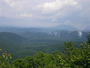
The state has four primary mountain ranges: the Arbuckle Mountains
, the Wichita Mountains
, the Ozark Mountains and the Ouachita Mountains
. Part of the U.S. Interior Highlands region, the Ozarks and Ouachitas form the only major highland region between the Rocky Mountains
and the Appalachians.
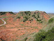
A portion of the Flint Hills
stretches into north-central Oklahoma, and in the state's southeastern corner, Cavanal Hill
is officially regarded as the world's tallest hill; at 1,999 feet (609 m), it fails the definition of a mountain by one foot. More than 500 named creeks and rivers make up Oklahoma's waterways, and with 200 lakes created by dams, it holds the highest number of reservoirs in the nation.
Oklahoma covers an area of 69898 square miles (181,035 km²), with 68667 square miles (177,846.7 km²) of land and 1231 square miles (3,188.3 km²) of water, making it the 20th-largest state in the United States. Generally, it is divided into six geographical regions: Green Country, or Northeast Oklahoma, Southeastern Oklahoma, Central Oklahoma
, South Central Oklahoma
, Southwest Oklahoma, and Northwest Oklahoma.
Situated between the Great Plains
and the Ozark Plateau in the Gulf of Mexico
watershed, Oklahoma tends to slope gradually downward from its western to eastern boundaries. Its highest and lowest points follow this trend, with its highest peak, Black Mesa, at 4368 feet (1,516 m) above sea level, situated near the far northwest corner of the Oklahoma Panhandle
. The state's lowest point is on the Little River near its far southeastern boundary, which dips to 289 feet (88 m) above sea level.
Most of the state lies in two primary drainage basin
s belonging to the Red
and Arkansas
rivers, though the Lee and Little rivers also contain significant drainage basins. In the state’s northwestern corner
, semi-arid
high plains
harbor few natural forests and rolling to flat landscape with intermittent canyons and mesa
ranges like the Glass Mountains
. Partial plains interrupted by small mountain ranges like the Antelope Hills
and the Wichita Mountains
dot southwestern Oklahoma
, and transitional prairie and woodlands cover the central portion
of the state. The Ozark and Ouachita Mountains rise from west to east over the state's eastern third, gradually increasing in elevation in an eastward direction.
 Forests cover 24 percent of Oklahoma, and prairie grasslands
, composed of shortgrass, mixed-grass, and tallgrass prairie
, harbor expansive ecosystems in the state's central and western portions. Where rainfall is sparse in the western regions of the state, shortgrass prairie and shrubland
s are the most prominent ecosystems, though pinyon pine
s, juniper
s, and ponderosa pine
s grow near rivers and creek beds in the far western reaches of the panhandle. Marshlands, cypress
forests and mixtures of shortleaf pine
, loblolly pine
and deciduous forests dominate the state's southeastern quarter
, while mixtures of largely post oak
, elm
, cedar
and pine forests cover the Ozark Mountains in northeastern Oklahoma.
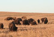
The state holds large populations of white-tailed deer
, coyotes, bobcats, elk
, and birds such as quail
, dove
s, cardinals
, bald eagles, red-tailed hawks, and pheasants. In prairie ecosystems, american bison
, greater prairie-chickens, badgers, and armadillo
are common, and some of the nation's largest prairie dog
towns inhabit shortgrass prairie in the state's panhandle. The Cross Timbers
, a region transitioning from prairie to woodlands in Central Oklahoma, harbors 351 vertebrate species
. The Ouachita Mountains are home to black bear
, red fox
, grey fox, and river otter populations, which coexist with a total of 328 vertebrate species in southeastern Oklahoma.
 Oklahoma has 50 state parks, six national parks or protected regions, two national protected forests
or grasslands, and a network of wildlife preserves and conservation areas. Six percent of the state's 10 million acres (40,000 km²) of forest is public land, including the western portions of the Ouachita National Forest
, the largest and oldest national forest in the southern United States. With 39000 acres (157.8 km²), the Tallgrass Prairie Preserve
in north-central Oklahoma is the largest protected area of tallgrass prairie
in the world and is part of an ecosystem
that encompasses only 10 percent of its former land area, once covering 14 states. In addition, the Black Kettle National Grassland covers 31300 acres (126.7 km²) of prairie in southwestern Oklahoma. The Wichita Mountains Wildlife Refuge is the oldest and largest of nine national wildlife refuges
in the state and was founded in 1901, encompassing 59020 acres (238.8 km²). Of Oklahoma's federally protected park or recreational sites, the Chickasaw National Recreation Area
is the largest, with 4500 acres (18.2 km²). Other federal protected sites include the Santa Fe and Trail of Tears
national historic trails, the Fort Smith
and Washita Battlefield
national historic sites, and the Oklahoma City National Memorial
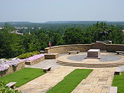
.
between regions of differing prevailing winds, making its weather widely different between relatively short distances. Much of the state is often subjected to extremes in temperature, wind, drought, and rainfall. Most of the state lies in an area known as Tornado Alley
characterized by frequent interaction between cold and warm air masses producing severe weather
. An average 54 tornadoes strike the state per year—one of the highest rates in the world. Because of its position between zones of differing prevailing temperature and winds, weather patterns within the state can vary widely between relatively short distances.
 Eastern Oklahoma has a humid subtropical climate
(Koppen Cfa) heavily influenced by southerly winds bringing moisture from the Gulf of Mexico
and provides hot, humid summers and generally mild winters with cold spells. This transitions progressively to a semi-arid
zone (Koppen BSk) in the high plains
of the Panhandle, where a drier climate prevails with somewhat colder winters and similarly hot summers but much lower humidity. Other western areas of the state, including Lawton
and Enid
in the transition zone, are also less touched by southern moisture and tend to be drier. Precipitation and temperatures fall from east to west accordingly, with areas in the southeast averaging an annual temperature of 62 °F (17 °C) and an annual rainfall of 56 inches (1,422.4 mm), while areas of the panhandle average 58 °F (14 °C), with an annual rainfall under 17 inches (431.8 mm). All of the state frequently experiences temperatures above 100 °F (38 °C) or below 0 °F (−18 °C), and snowfall ranges from an average of less than 4 inches (10 cm) in the south to just over 20 inches (51 cm) on the border of Colorado
in the panhandle. The state is home to the National Storm Prediction Center
of the National Weather Service
located at Norman
.
Oklahoma
Oklahoma is a state located in the South Central region of the United States of America. With an estimated 3,751,351 residents as of the 2010 census and a land area of 68,667 square miles , Oklahoma is the 28th most populous and 20th-largest state...
contains 11 distinct ecological regions
Ecoregion
An ecoregion , sometimes called a bioregion, is an ecologically and geographically defined area that is smaller than an ecozone and larger than an ecosystem. Ecoregions cover relatively large areas of land or water, and contain characteristic, geographically distinct assemblages of natural...
, more per square mile than in any other state by a wide margin. One of six states on the Frontier Strip
Frontier Strip
The Frontier Strip are the six states in the United States forming a north-south line from North Dakota to Texas. In the American Old West, westward from this strip was the frontier of the United States toward the latter part of the 19th century...
, it is situated in the Great Plains
Great Plains
The Great Plains are a broad expanse of flat land, much of it covered in prairie, steppe and grassland, which lies west of the Mississippi River and east of the Rocky Mountains in the United States and Canada. This area covers parts of the U.S...
and U.S. Interior Highlands region
U.S. Interior Highlands
The U.S. Interior Highlands is a mountainous region spanning eastern Oklahoma, western and northern Arkansas, southern Missouri, and the extreme southeast corner of Kansas. The name is designated by the United States Geological Survey to refer to the combined mountainous region of the Ozarks and...
near the geographical center of the 48 contiguous states. Usually considered part of the South Central United States
South Central United States
The South Central United States or South Central states is a region of the United States located in the south central part of the country. It evolved out of the archaic southwest, which originally was literally the western U.S. South...
, Oklahoma is bounded on the east by Arkansas
Arkansas
Arkansas is a state located in the southern region of the United States. Its name is an Algonquian name of the Quapaw Indians. Arkansas shares borders with six states , and its eastern border is largely defined by the Mississippi River...
and Missouri
Missouri
Missouri is a US state located in the Midwestern United States, bordered by Iowa, Illinois, Kentucky, Tennessee, Arkansas, Oklahoma, Kansas and Nebraska. With a 2010 population of 5,988,927, Missouri is the 18th most populous state in the nation and the fifth most populous in the Midwest. It...
, on the north by Kansas
Kansas
Kansas is a US state located in the Midwestern United States. It is named after the Kansas River which flows through it, which in turn was named after the Kansa Native American tribe, which inhabited the area. The tribe's name is often said to mean "people of the wind" or "people of the south...
, on the northwest by Colorado
Colorado
Colorado is a U.S. state that encompasses much of the Rocky Mountains as well as the northeastern portion of the Colorado Plateau and the western edge of the Great Plains...
, on the far west by New Mexico
New Mexico
New Mexico is a state located in the southwest and western regions of the United States. New Mexico is also usually considered one of the Mountain States. With a population density of 16 per square mile, New Mexico is the sixth-most sparsely inhabited U.S...
, and on the south and near-west by Texas
Texas
Texas is the second largest U.S. state by both area and population, and the largest state by area in the contiguous United States.The name, based on the Caddo word "Tejas" meaning "friends" or "allies", was applied by the Spanish to the Caddo themselves and to the region of their settlement in...
.
The state has four primary mountain ranges: the Arbuckle Mountains
Arbuckle Mountains
The Arbuckle Mountains are an ancient mountain range in south-central Oklahoma in the United States. The granite rocks of the Arbuckles date back to the Proterozoic Era some 1.4 billion years ago which were overlain by sediments during the Paleozoic Era. The range reaches a height of 1,412 feet...
, the Wichita Mountains
Wichita Mountains
The Wichita Mountains are located in the southwestern portion of the U.S. state of Oklahoma. The mountains are a northwest-southeast trending series of rocky promontories, many capped by 540 million-year old granite. These were exposed and rounded by weathering during the Permian Period...
, the Ozark Mountains and the Ouachita Mountains
Ouachita Mountains
The Ouachita Mountains are a mountain range in west central Arkansas and southeastern Oklahoma. The range's subterranean roots may extend as far as central Texas, or beyond it to the current location of the Marathon Uplift. Along with the Ozark Mountains, the Ouachita Mountains form the U.S...
. Part of the U.S. Interior Highlands region, the Ozarks and Ouachitas form the only major highland region between the Rocky Mountains
Rocky Mountains
The Rocky Mountains are a major mountain range in western North America. The Rocky Mountains stretch more than from the northernmost part of British Columbia, in western Canada, to New Mexico, in the southwestern United States...
and the Appalachians.
A portion of the Flint Hills
Flint Hills
The Flint Hills, historically known as Bluestem Pastures or Blue Stem Hills, are a band of hills in eastern Kansas stretching into north-central Oklahoma, extending from Marshall County, Kansas and Washington County, Kansas in the north to Cowley County, Kansas and Osage County, Oklahoma in the south...
stretches into north-central Oklahoma, and in the state's southeastern corner, Cavanal Hill
Cavanal Hill
Cavanal Hill , located near Poteau, Oklahoma, is billed by a local chamber of commerce as the tallest hill in the world at...
is officially regarded as the world's tallest hill; at 1,999 feet (609 m), it fails the definition of a mountain by one foot. More than 500 named creeks and rivers make up Oklahoma's waterways, and with 200 lakes created by dams, it holds the highest number of reservoirs in the nation.
Oklahoma covers an area of 69898 square miles (181,035 km²), with 68667 square miles (177,846.7 km²) of land and 1231 square miles (3,188.3 km²) of water, making it the 20th-largest state in the United States. Generally, it is divided into six geographical regions: Green Country, or Northeast Oklahoma, Southeastern Oklahoma, Central Oklahoma
Central Oklahoma
Central Oklahoma is the geographical name for the central region of the U.S. state of Oklahoma. It is also known by the Oklahoma Department of Tourism designation, Frontier Country....
, South Central Oklahoma
South Central Oklahoma
South Central Oklahoma, or Arbuckle Country, as officially defined by the Oklahoma Department of Tourism, is an amorphous 10-county region in the state of Oklahoma...
, Southwest Oklahoma, and Northwest Oklahoma.
Topography
Situated between the Great Plains
Great Plains
The Great Plains are a broad expanse of flat land, much of it covered in prairie, steppe and grassland, which lies west of the Mississippi River and east of the Rocky Mountains in the United States and Canada. This area covers parts of the U.S...
and the Ozark Plateau in the Gulf of Mexico
Gulf of Mexico
The Gulf of Mexico is a partially landlocked ocean basin largely surrounded by the North American continent and the island of Cuba. It is bounded on the northeast, north and northwest by the Gulf Coast of the United States, on the southwest and south by Mexico, and on the southeast by Cuba. In...
watershed, Oklahoma tends to slope gradually downward from its western to eastern boundaries. Its highest and lowest points follow this trend, with its highest peak, Black Mesa, at 4368 feet (1,516 m) above sea level, situated near the far northwest corner of the Oklahoma Panhandle
Oklahoma Panhandle
The Oklahoma Panhandle is the extreme western region of the state of Oklahoma, comprising Cimarron County, Texas County, and Beaver County. Its name comes from the similarity of shape to the handle of a cooking pan....
. The state's lowest point is on the Little River near its far southeastern boundary, which dips to 289 feet (88 m) above sea level.
Most of the state lies in two primary drainage basin
Drainage basin
A drainage basin is an extent or an area of land where surface water from rain and melting snow or ice converges to a single point, usually the exit of the basin, where the waters join another waterbody, such as a river, lake, reservoir, estuary, wetland, sea, or ocean...
s belonging to the Red
Red River (Mississippi watershed)
The Red River, or sometimes the Red River of the South, is a major tributary of the Mississippi and Atchafalaya Rivers in the southern United States of America. The river gains its name from the red-bed country of its watershed. It is one of several rivers with that name...
and Arkansas
Arkansas River
The Arkansas River is a major tributary of the Mississippi River. The Arkansas generally flows to the east and southeast as it traverses the U.S. states of Colorado, Kansas, Oklahoma, and Arkansas. The river's initial basin starts in the Western United States in Colorado, specifically the Arkansas...
rivers, though the Lee and Little rivers also contain significant drainage basins. In the state’s northwestern corner
Northwestern Oklahoma
Northwestern Oklahoma is the geographical region of the state of Oklahoma which includes the Oklahoma Panhandle and a majority of the Cherokee Outlet, stretching to an eastern extent along Interstate 35, and its southern extent along the Canadian River to Noble County...
, semi-arid
Semi-arid
A semi-arid climate or steppe climate describes climatic regions that receive precipitation below potential evapotranspiration, but not extremely...
high plains
High Plains (United States)
The High Plains are a subregion of the Great Plains mostly in the Western United States, but also partly in the Midwest states of Nebraska, Kansas, and South Dakota, generally encompassing the western part of the Great Plains before the region reaches the Rocky Mountains...
harbor few natural forests and rolling to flat landscape with intermittent canyons and mesa
Mesa
A mesa or table mountain is an elevated area of land with a flat top and sides that are usually steep cliffs. It takes its name from its characteristic table-top shape....
ranges like the Glass Mountains
Glass Mountains
The Glass Mountains or Gloss Mountains are a series of mesas and buttes that extend from the Permian red beds of the Blaine Escarpment of northwestern Oklahoma in Major County. The Glass Mountains stretch west along US Highway 412 from Orienta south of the Cimarron River...
. Partial plains interrupted by small mountain ranges like the Antelope Hills
Antelope Hills
-Communities:* Antelope Hills, California, Kern County, California* Antelope Hills, Colorado, Arapahoe County, Bennett, Colorado* Antelope Hills, Wyoming, Natrona County, Wyoming...
and the Wichita Mountains
Wichita Mountains
The Wichita Mountains are located in the southwestern portion of the U.S. state of Oklahoma. The mountains are a northwest-southeast trending series of rocky promontories, many capped by 540 million-year old granite. These were exposed and rounded by weathering during the Permian Period...
dot southwestern Oklahoma
Southwestern Oklahoma
Southwest Oklahoma is a geographical name for the southwest portion of the state of Oklahoma, typically considered to be south of the Canadian River, extending eastward from the Texas border to a line roughly from Weatherford, to Anadarko, to Duncan...
, and transitional prairie and woodlands cover the central portion
Central Oklahoma
Central Oklahoma is the geographical name for the central region of the U.S. state of Oklahoma. It is also known by the Oklahoma Department of Tourism designation, Frontier Country....
of the state. The Ozark and Ouachita Mountains rise from west to east over the state's eastern third, gradually increasing in elevation in an eastward direction.
Flora and fauna
Prairie
Prairies are considered part of the temperate grasslands, savannas, and shrublands biome by ecologists, based on similar temperate climates, moderate rainfall, and grasses, herbs, and shrubs, rather than trees, as the dominant vegetation type...
, composed of shortgrass, mixed-grass, and tallgrass prairie
Tallgrass prairie
The tallgrass prairie is an ecosystem native to central North America, with fire as its primary periodic disturbance. In the past, tallgrass prairies covered a large portion of the American Midwest, just east of the Great Plains, and portions of the Canadian Prairies. They flourished in areas with...
, harbor expansive ecosystems in the state's central and western portions. Where rainfall is sparse in the western regions of the state, shortgrass prairie and shrubland
Shrubland
Shrubland, scrubland, scrub or brush is a plant community characterized by vegetation dominated by shrubs, often also including grasses, herbs, and geophytes. Shrubland may either occur naturally or be the result of human activity...
s are the most prominent ecosystems, though pinyon pine
Pinyon pine
The pinyon pine group grows in the southwestern United States and in Mexico. The trees yield edible pinyon nuts, which were a staple of the Native Americans, and are still widely eaten...
s, juniper
Juniper
Junipers are coniferous plants in the genus Juniperus of the cypress family Cupressaceae. Depending on taxonomic viewpoint, there are between 50-67 species of juniper, widely distributed throughout the northern hemisphere, from the Arctic, south to tropical Africa in the Old World, and to the...
s, and ponderosa pine
Ponderosa Pine
Pinus ponderosa, commonly known as the Ponderosa Pine, Bull Pine, Blackjack Pine, or Western Yellow Pine, is a widespread and variable pine native to western North America. It was first described by David Douglas in 1826, from eastern Washington near present-day Spokane...
s grow near rivers and creek beds in the far western reaches of the panhandle. Marshlands, cypress
Cypress
Cypress is the name applied to many plants in the cypress family Cupressaceae, which is a conifer of northern temperate regions. Most cypress species are trees, while a few are shrubs...
forests and mixtures of shortleaf pine
Shortleaf Pine
Pinus echinata is a species of pine native to the eastern United States from southern New York south to northern Florida, west to the extreme southeast of Kansas, and southwest to eastern Texas. The tree is variable in form, sometimes straight, sometimes crooked, with an irregular crown...
, loblolly pine
Loblolly Pine
Pinus taeda is one of several pines native to the Southeastern United States, from central Texas east to Florida, and north to Delaware. It is particularly dominant in the eastern half of North Carolina, where there are huge expanses consisting solely of Loblolly Pine trees...
and deciduous forests dominate the state's southeastern quarter
Kiamichi country
Southeastern Oklahoma, also known by its official tourism designation, Kiamichi Country, encompasses the southeastern quarter of the state of Oklahoma. The term "Kiamichi Country" was coined by the Oklahoma Department of Tourism and Recreation as one of six travel destination regions within the...
, while mixtures of largely post oak
Post oak
Quercus stellata is an oak in the white oak group. It is a small tree, typically 10–15 m tall and 30–60 cm trunk diameter, though occasional specimens reach 30 m tall and 140 cm diameter. It is native to the eastern United States, from Connecticut in the northeast, west to southern Iowa, southwest...
, elm
Elm
Elms are deciduous and semi-deciduous trees comprising the genus Ulmus in the plant family Ulmaceae. The dozens of species are found in temperate and tropical-montane regions of North America and Eurasia, ranging southward into Indonesia. Elms are components of many kinds of natural forests...
, cedar
Cedar wood
Cedar wood comes from several different trees that grow in different parts of the world, and may have different uses.* California incense-cedar, from Calocedrus decurrens, is the primary type of wood used for making pencils...
and pine forests cover the Ozark Mountains in northeastern Oklahoma.
The state holds large populations of white-tailed deer
White-tailed Deer
The white-tailed deer , also known as the Virginia deer or simply as the whitetail, is a medium-sized deer native to the United States , Canada, Mexico, Central America, and South America as far south as Peru...
, coyotes, bobcats, elk
Elk
The Elk is the large deer, also called Cervus canadensis or wapiti, of North America and eastern Asia.Elk may also refer to:Other antlered mammals:...
, and birds such as quail
Quail
Quail is a collective name for several genera of mid-sized birds generally considered in the order Galliformes. Old World quail are found in the family Phasianidae, while New World quail are found in the family Odontophoridae...
, dove
Dove
Pigeons and doves constitute the bird family Columbidae within the order Columbiformes, which include some 300 species of near passerines. In general terms "dove" and "pigeon" are used somewhat interchangeably...
s, cardinals
Cardinal (bird)
The Cardinals or Cardinalidae are a family of passerine birds found in North and South America. The South American cardinals in the genus Paroaria are placed in another family, the Thraupidae ....
, bald eagles, red-tailed hawks, and pheasants. In prairie ecosystems, american bison
American Bison
The American bison , also commonly known as the American buffalo, is a North American species of bison that once roamed the grasslands of North America in massive herds...
, greater prairie-chickens, badgers, and armadillo
Armadillo
Armadillos are New World placental mammals, known for having a leathery armor shell. Dasypodidae is the only surviving family in the order Cingulata, part of the superorder Xenarthra along with the anteaters and sloths. The word armadillo is Spanish for "little armored one"...
are common, and some of the nation's largest prairie dog
Prairie dog
Prairie dogs are burrowing rodents native to the grasslands of North America. There are five different species of prairie dogs: black-tailed, white-tailed, Gunnison's, Utah and Mexican prairie dogs. They are a type of ground squirrel, found in the United States, Canada and Mexico...
towns inhabit shortgrass prairie in the state's panhandle. The Cross Timbers
Cross Timbers
The term Cross Timbers is used to describe a strip of land in the United States that runs from southeastern Kansas across Central Oklahoma to Central Texas...
, a region transitioning from prairie to woodlands in Central Oklahoma, harbors 351 vertebrate species
Vertebrate
Vertebrates are animals that are members of the subphylum Vertebrata . Vertebrates are the largest group of chordates, with currently about 58,000 species described. Vertebrates include the jawless fishes, bony fishes, sharks and rays, amphibians, reptiles, mammals, and birds...
. The Ouachita Mountains are home to black bear
American black bear
The American black bear is a medium-sized bear native to North America. It is the continent's smallest and most common bear species. Black bears are omnivores, with their diets varying greatly depending on season and location. They typically live in largely forested areas, but do leave forests in...
, red fox
Red Fox
The red fox is the largest of the true foxes, as well as being the most geographically spread member of the Carnivora, being distributed across the entire northern hemisphere from the Arctic Circle to North Africa, Central America, and the steppes of Asia...
, grey fox, and river otter populations, which coexist with a total of 328 vertebrate species in southeastern Oklahoma.
Protected lands
United States National Forest
National Forest is a classification of federal lands in the United States.National Forests are largely forest and woodland areas owned by the federal government and managed by the United States Forest Service, part of the United States Department of Agriculture. Land management of these areas...
or grasslands, and a network of wildlife preserves and conservation areas. Six percent of the state's 10 million acres (40,000 km²) of forest is public land, including the western portions of the Ouachita National Forest
Ouachita National Forest
The Ouachita National Forest is a National Forest that lies in the western portion of Arkansas and portions of eastern Oklahoma.-History:The Ouachita National Forest is the oldest National Forest in the southern United States. The Forest encompasses , including most of the scenic Ouachita Mountains...
, the largest and oldest national forest in the southern United States. With 39000 acres (157.8 km²), the Tallgrass Prairie Preserve
Tallgrass Prairie Preserve
The Tallgrass Prairie Preserve, located in Osage County, Oklahoma near Foraker, Oklahoma, is owned and managed by The Nature Conservancy. It is protected as the largest tract of remaining tallgrass prairie in the world...
in north-central Oklahoma is the largest protected area of tallgrass prairie
Tallgrass prairie
The tallgrass prairie is an ecosystem native to central North America, with fire as its primary periodic disturbance. In the past, tallgrass prairies covered a large portion of the American Midwest, just east of the Great Plains, and portions of the Canadian Prairies. They flourished in areas with...
in the world and is part of an ecosystem
Ecosystem
An ecosystem is a biological environment consisting of all the organisms living in a particular area, as well as all the nonliving , physical components of the environment with which the organisms interact, such as air, soil, water and sunlight....
that encompasses only 10 percent of its former land area, once covering 14 states. In addition, the Black Kettle National Grassland covers 31300 acres (126.7 km²) of prairie in southwestern Oklahoma. The Wichita Mountains Wildlife Refuge is the oldest and largest of nine national wildlife refuges
National Wildlife Refuge
National Wildlife Refuge is a designation for certain protected areas of the United States managed by the United States Fish and Wildlife Service. The National Wildlife Refuge System is the world's premiere system of public lands and waters set aside to conserve America's fish, wildlife and plants...
in the state and was founded in 1901, encompassing 59020 acres (238.8 km²). Of Oklahoma's federally protected park or recreational sites, the Chickasaw National Recreation Area
Chickasaw National Recreation Area
Chickasaw National Recreation Areais a National Recreation Area situated in the foothills of the Arbuckle Mountains in south-central Oklahoma near Sulphur.-History:...
is the largest, with 4500 acres (18.2 km²). Other federal protected sites include the Santa Fe and Trail of Tears
Trail of Tears
The Trail of Tears is a name given to the forced relocation and movement of Native American nations from southeastern parts of the United States following the Indian Removal Act of 1830...
national historic trails, the Fort Smith
Fort Smith National Historic Site
Fort Smith National Historic Site is a United States National Historic Site located primarily in Fort Smith, Arkansas along the Arkansas River, and also along the opposite bank of the river near Moffett, Oklahoma....
and Washita Battlefield
Washita Battlefield National Historic Site
Washita Battlefield National Historic Site protects and interprets the site of the Southern Cheyenne village of Chief Black Kettle where the Battle of Washita occurred. The site, a National Historic Landmark, is located about 150 miles west of Oklahoma City, Oklahoma, near Cheyenne, Oklahoma.Just...
national historic sites, and the Oklahoma City National Memorial
Oklahoma City National Memorial
The Oklahoma City National Memorial is a memorial in the United States that honors the victims, survivors, rescuers, and all who were affected by the Oklahoma City bombing on April 19, 1995. The memorial is located in downtown Oklahoma City on the former site of the Alfred P. Murrah Federal...
.
Climate
Oklahoma is situated in a temperate continental climateContinental climate
Continental climate is a climate characterized by important annual variation in temperature due to the lack of significant bodies of water nearby...
between regions of differing prevailing winds, making its weather widely different between relatively short distances. Much of the state is often subjected to extremes in temperature, wind, drought, and rainfall. Most of the state lies in an area known as Tornado Alley
Tornado Alley
Tornado Alley is a colloquial and popular media term that most often refers to the area of the United States where tornadoes are most frequent. Although an official location is not defined, the area between the Rocky Mountains and Appalachian Mountains is usually associated with it.The areas...
characterized by frequent interaction between cold and warm air masses producing severe weather
Severe weather
Severe weather phenomena are weather conditions that are hazardous to human life and property.- Examples Include :Severe weather can occur under a variety of situations, but three characteristics are generally needed: a temperature or moisture boundary, moisture, and , instability in the...
. An average 54 tornadoes strike the state per year—one of the highest rates in the world. Because of its position between zones of differing prevailing temperature and winds, weather patterns within the state can vary widely between relatively short distances.
Humid subtropical climate
A humid subtropical climate is a climate zone characterized by hot, humid summers and mild to cool winters...
(Koppen Cfa) heavily influenced by southerly winds bringing moisture from the Gulf of Mexico
Gulf of Mexico
The Gulf of Mexico is a partially landlocked ocean basin largely surrounded by the North American continent and the island of Cuba. It is bounded on the northeast, north and northwest by the Gulf Coast of the United States, on the southwest and south by Mexico, and on the southeast by Cuba. In...
and provides hot, humid summers and generally mild winters with cold spells. This transitions progressively to a semi-arid
Semi-arid
A semi-arid climate or steppe climate describes climatic regions that receive precipitation below potential evapotranspiration, but not extremely...
zone (Koppen BSk) in the high plains
Great Plains
The Great Plains are a broad expanse of flat land, much of it covered in prairie, steppe and grassland, which lies west of the Mississippi River and east of the Rocky Mountains in the United States and Canada. This area covers parts of the U.S...
of the Panhandle, where a drier climate prevails with somewhat colder winters and similarly hot summers but much lower humidity. Other western areas of the state, including Lawton
Lawton, Oklahoma
The city of Lawton is the county seat of Comanche County, in the U.S. state of Oklahoma. Located in the southwestern region of Oklahoma approximately southwest of Oklahoma City, it is the principal city of the Lawton Oklahoma Metropolitan Statistical Area...
and Enid
Enid, Oklahoma
Enid is a city in Garfield County, Oklahoma, United States. In 2010, the population was 49,379, making it the ninth largest city in Oklahoma. It is the county seat of Garfield County. Enid was founded during the opening of the Cherokee Outlet in the Land Run of 1893, and is named after Enid, a...
in the transition zone, are also less touched by southern moisture and tend to be drier. Precipitation and temperatures fall from east to west accordingly, with areas in the southeast averaging an annual temperature of 62 °F (17 °C) and an annual rainfall of 56 inches (1,422.4 mm), while areas of the panhandle average 58 °F (14 °C), with an annual rainfall under 17 inches (431.8 mm). All of the state frequently experiences temperatures above 100 °F (38 °C) or below 0 °F (−18 °C), and snowfall ranges from an average of less than 4 inches (10 cm) in the south to just over 20 inches (51 cm) on the border of Colorado
Colorado
Colorado is a U.S. state that encompasses much of the Rocky Mountains as well as the northeastern portion of the Colorado Plateau and the western edge of the Great Plains...
in the panhandle. The state is home to the National Storm Prediction Center
Storm Prediction Center
The Storm Prediction Center , located in Norman, Oklahoma, is tasked with forecasting the risk of severe thunderstorms and tornadoes in the contiguous United States. The agency issues convective outlooks, mesoscale discussions, and watches as a part of this process...
of the National Weather Service
National Weather Service
The National Weather Service , once known as the Weather Bureau, is one of the six scientific agencies that make up the National Oceanic and Atmospheric Administration of the United States government...
located at Norman
Norman, Oklahoma
Norman is a city in Cleveland County, Oklahoma, United States, and is located south of downtown Oklahoma City. It is part of the Oklahoma City metropolitan area. As of the 2010 census, Norman was to have 110,925 full-time residents, making it the third-largest city in Oklahoma and the...
.