

Geography of Nova Scotia
Encyclopedia
Nova Scotia
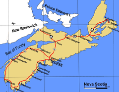
Nova Scotia is one of Canada's three Maritime provinces and is the most populous province in Atlantic Canada. The name of the province is Latin for "New Scotland," but "Nova Scotia" is the recognized, English-language name of the province. The provincial capital is Halifax. Nova Scotia is the...
is a province located in eastern Canada
Eastern Canada
Eastern Canada is generally considered to be the region of Canada east of Manitoba, consisting of the following provinces:* New Brunswick* Newfoundland and Labrador* Nova Scotia* Ontario* Prince Edward Island* Quebec...
fronting the Atlantic Ocean
Atlantic Ocean
The Atlantic Ocean is the second-largest of the world's oceanic divisions. With a total area of about , it covers approximately 20% of the Earth's surface and about 26% of its water surface area...
. One of the Maritime Provinces
Maritimes
The Maritime provinces, also called the Maritimes or the Canadian Maritimes, is a region of Eastern Canada consisting of three provinces, New Brunswick, Nova Scotia, and Prince Edward Island. On the Atlantic coast, the Maritimes are a subregion of Atlantic Canada, which also includes the...
, Nova Scotia's geography is complex, despite its relatively small size in comparison to other Canadian provinces.
Physical geography
Nova Scotia peninsula
The Nova Scotia peninsula is a peninsula on the Atlantic coast of North America.-Location:The Nova Scotia peninsula is part of the province of Nova Scotia, Canada and is connected to the neighbouring province of New Brunswick through the Isthmus of Chignecto...
is attached to North America through the Isthmus of Chignecto
Isthmus of Chignecto
The Isthmus of Chignecto is an isthmus bordering the Maritime provinces of New Brunswick and Nova Scotia which connects the Nova Scotia peninsula with North America....
. Various offshore islands, the largest of which is Cape Breton Island
Cape Breton Island
Cape Breton Island is an island on the Atlantic coast of North America. It likely corresponds to the word Breton, the French demonym for Brittany....
, form the bulk of the eastern part of the province.
The geological
Geology
Geology is the science comprising the study of solid Earth, the rocks of which it is composed, and the processes by which it evolves. Geology gives insight into the history of the Earth, as it provides the primary evidence for plate tectonics, the evolutionary history of life, and past climates...
history of the province spans more than 1.2 billion years http://museum.gov.ns.ca/mnh/nature/nhns/t2/t2-1.htm. Continental drift
Continental drift
Continental drift is the movement of the Earth's continents relative to each other. The hypothesis that continents 'drift' was first put forward by Abraham Ortelius in 1596 and was fully developed by Alfred Wegener in 1912...
led to the southern half of the province's mainland portion once being attached to Africa
Africa
Africa is the world's second largest and second most populous continent, after Asia. At about 30.2 million km² including adjacent islands, it covers 6% of the Earth's total surface area and 20.4% of the total land area...
whereas the northern half, including Cape Breton Island, was once attached to Scandinavia
Scandinavia
Scandinavia is a cultural, historical and ethno-linguistic region in northern Europe that includes the three kingdoms of Denmark, Norway and Sweden, characterized by their common ethno-cultural heritage and language. Modern Norway and Sweden proper are situated on the Scandinavian Peninsula,...
and Scotland
Scotland
Scotland is a country that is part of the United Kingdom. Occupying the northern third of the island of Great Britain, it shares a border with England to the south and is bounded by the North Sea to the east, the Atlantic Ocean to the north and west, and the North Channel and Irish Sea to the...
.
Nova Scotia has a great variety of coastal landforms. Most of the land in Nova Scotia is bedrock. As a result of erosion and transportation of unconsolidated material, landforms such as beaches and marshes are being formed. These deposits are also being eroded and/or flooded by the rising sea level.
Glaciation during the Quaternary Period had an overwhelming effect upon the landscape. Glaciers abraded and plucked at the bedrock during their advances across the country, creating various deposits that vary in thickness and form; in some places they are up to 300 meters thick.
Nova Scotia's numerous hills, several low mountain ranges (the entire province is located within the Appalachian Mountains
Appalachian Mountains
The Appalachian Mountains #Whether the stressed vowel is or ,#Whether the "ch" is pronounced as a fricative or an affricate , and#Whether the final vowel is the monophthong or the diphthong .), often called the Appalachians, are a system of mountains in eastern North America. The Appalachians...
), lush river valleys, lakes and forests, windswept barrens, and a varied sea coast ranging from extremely rugged to broad sand beaches, can be attributed to these forces.
Nova Scotia forms part of the southern shores of the Gulf of St. Lawrence and its sub-basin, the Northumberland Strait
Northumberland Strait
The Northumberland Strait is a strait in the southern part of the Gulf of Saint Lawrence in eastern Canada...
. The Cabot Strait
Cabot Strait
Cabot Strait is a strait in eastern Canada approximately 110 kilometres wide between Cape Ray, Newfoundland and Cape North, Cape Breton Island. It is the widest of the three outlets for the Gulf of Saint Lawrence into the Atlantic Ocean, the others being the Strait of Belle Isle and Strait of Canso...
lies north and east of Cape Breton Island. The main part of the Bay of Fundy
Bay of Fundy
The Bay of Fundy is a bay on the Atlantic coast of North America, on the northeast end of the Gulf of Maine between the Canadian provinces of New Brunswick and Nova Scotia, with a small portion touching the U.S. state of Maine...
lies off its northwestern shore, and large sub-basins including the Cumberland Basin, the Minas Basin
Minas Basin
The Minas Basin is an inlet of the Bay of Fundy and a sub-basin of the Fundy Basin located in Nova Scotia, Canada. It is known for its extremely high tides.- Geography :- Boundary :...
and Cobequid Bay
Cobequid Bay
Cobequid Bay is an inlet of the Bay of Fundy and the easternmost part of the Minas Basin, located in the Canadian province of Nova Scotia. The bay was carved by rivers flowing into the eastern end of the Bay of Fundy....
create major indentations into its coastline. The Gulf of Maine
Gulf of Maine
The Gulf of Maine is a large gulf of the Atlantic Ocean on the east coast of North America.It is delineated by Cape Cod at the eastern tip of Massachusetts in the southwest and Cape Sable at the southern tip of Nova Scotia in the northeast. It includes the entire coastlines of the U.S...
(of which the Bay of Fundy is a component) lies off the western shore. The South Shore
South Shore (Nova Scotia)
The South Shore is a region of Nova Scotia, Canada. Although it has no formal identity and is variously defined by geographic, county and other political boundaries, it is generally understood as the Atlantic coast running southwest from Halifax Harbour to the end of Shelburne County...
and Eastern Shore
Eastern Shore (Nova Scotia)
The Eastern Shore is a region of Nova Scotia Canada. It is the Atlantic coast running northeast from Halifax Harbour to the eastern end of the peninsula at the Strait of Canso....
, as well as the southern and eastern parts of Cape Breton Island constitute a pelagic coast, fronting the open Atlantic Ocean.
The Atlantic coast of Nova Scotia has numerous offshore fishing banks which are submerged sections of the continental shelf
Continental shelf
The continental shelf is the extended perimeter of each continent and associated coastal plain. Much of the shelf was exposed during glacial periods, but is now submerged under relatively shallow seas and gulfs, and was similarly submerged during other interglacial periods. The continental margin,...
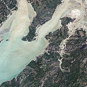
. Rising sea levels since glaciation have inundated many parts of the coatline, including these areas on the continental shelf, providing rich habitat for marine life, as well as defining other unique features such as various coastal islands, bays, harbours and the Bras d'Or Lake
Bras d'Or Lake
Bras d'Or Lake is a large body of salt water dominating the centre of Cape Breton Island in the province of Nova Scotia, Canada. Bras d'Or Lake is sometimes referred to as the Bras d'Or Lakes or the Bras d'Or Lakes system, however its official geographic name is Bras d'Or Lake as it is a singular...
- an 1100 square kilometres (424.7 sq mi) estuary
Estuary
An estuary is a partly enclosed coastal body of water with one or more rivers or streams flowing into it, and with a free connection to the open sea....
that defines the central portion of Cape Breton Island.
History Of Nova Scotia
European discovery resulted in settlements in protected natural harbours and along shorelines where convenient trade routes for sailing ships provided reliable transportation to markets in Europe
Europe
Europe is, by convention, one of the world's seven continents. Comprising the westernmost peninsula of Eurasia, Europe is generally 'divided' from Asia to its east by the watershed divides of the Ural and Caucasus Mountains, the Ural River, the Caspian and Black Seas, and the waterways connecting...
, New England
New England
New England is a region in the northeastern corner of the United States consisting of the six states of Maine, New Hampshire, Vermont, Massachusetts, Rhode Island, and Connecticut...
and the Caribbean
Caribbean
The Caribbean is a crescent-shaped group of islands more than 2,000 miles long separating the Gulf of Mexico and the Caribbean Sea, to the west and south, from the Atlantic Ocean, to the east and north...
. European settlers brought industrial fishing technologies and introduced large-scale forestry to sustain settlement construction and shipbuilding activities.
Wars between European military powers, notably Britain
Kingdom of Great Britain
The former Kingdom of Great Britain, sometimes described as the 'United Kingdom of Great Britain', That the Two Kingdoms of Scotland and England, shall upon the 1st May next ensuing the date hereof, and forever after, be United into One Kingdom by the Name of GREAT BRITAIN. was a sovereign...
and France
France
The French Republic , The French Republic , The French Republic , (commonly known as France , is a unitary semi-presidential republic in Western Europe with several overseas territories and islands located on other continents and in the Indian, Pacific, and Atlantic oceans. Metropolitan France...
, resulted in various territorial claims and numerous defense works established along Nova Scotia's coastal settlements and inland trade routes. The largest of these defensive installations was a French military fortified port at Louisbourg Harbour on Cape Breton Island. The fortified military port of Halifax
City of Halifax
Halifax is a city in Canada, which was the capital of the province of Nova Scotia and shire town of Halifax County. It was the largest city in Atlantic Canada until it was amalgamated into Halifax Regional Municipality in 1996...
on Halifax Harbour
Halifax Harbour
Halifax Harbour is a large natural harbour on the Atlantic coast of Nova Scotia, Canada, located in the Halifax Regional Municipality.-Harbour description:The harbour is called Jipugtug by the Mi'kmaq first nation, anglisized as Chebucto...
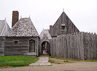
was similarly founded to counter Louisbourg's presence. A French settlement at Port-Royal
Habitation at Port-Royal
The Habitation at Port-Royal was the first successful French settlement of New France in North America, and is presently known as Port-Royal National Historic Site, a National Historic Site located on the northern side of the Annapolis Basin, Nova Scotia, Canada...
is currently the second longest continuously occupied European settlement in North America (after St. Augustine, Florida
St. Augustine, Florida
St. Augustine is a city in the northeast section of Florida and the county seat of St. Johns County, Florida, United States. Founded in 1565 by Spanish explorer and admiral Pedro Menéndez de Avilés, it is the oldest continuously occupied European-established city and port in the continental United...
).
Originally part of Acadia
Acadia
Acadia was the name given to lands in a portion of the French colonial empire of New France, in northeastern North America that included parts of eastern Quebec, the Maritime provinces, and modern-day Maine. At the end of the 16th century, France claimed territory stretching as far south as...
, the territory fluctuated for several decades through competing claims from Scotland
Scotland
Scotland is a country that is part of the United Kingdom. Occupying the northern third of the island of Great Britain, it shares a border with England to the south and is bounded by the North Sea to the east, the Atlantic Ocean to the north and west, and the North Channel and Irish Sea to the...
(under Sir William Alexander, who gave the territory the name "Nova Scotia" in honour of his homeland) and England
England
England is a country that is part of the United Kingdom. It shares land borders with Scotland to the north and Wales to the west; the Irish Sea is to the north west, the Celtic Sea to the south west, with the North Sea to the east and the English Channel to the south separating it from continental...
. France relinquished Acadia in 1713 under the Treaty of Utrecht
Treaty of Utrecht
The Treaty of Utrecht, which established the Peace of Utrecht, comprises a series of individual peace treaties, rather than a single document, signed by the belligerents in the War of Spanish Succession, in the Dutch city of Utrecht in March and April 1713...
. However, the boundaries were not delineated, and Britain only gained control of present-day peninsular Nova Scotia. Britain's colonial capital was established at Annapolis Royal
Annapolis Royal, Nova Scotia
Annapolis Royal is a town located in the western part of Annapolis County, Nova Scotia. Known as Port Royal until the Conquest of Acadia in 1710 by Britain, the town is the oldest continuous European settlement in North America, north of St...
, while France maintained control of Cape Breton Island (which they called Île Royale). The French territory of Acadia and New France finally fell permanently to Britain at the end of the Seven Years' War
Seven Years' War
The Seven Years' War was a global military war between 1756 and 1763, involving most of the great powers of the time and affecting Europe, North America, Central America, the West African coast, India, and the Philippines...
in 1756. The colonial capital was transferred from Annapolis Royal to Halifax
City of Halifax
Halifax is a city in Canada, which was the capital of the province of Nova Scotia and shire town of Halifax County. It was the largest city in Atlantic Canada until it was amalgamated into Halifax Regional Municipality in 1996...
in 1749 upon the establishment of that community.
Under British control, Acadian farming settlements that had been abandoned under the Great Upheaval
Great Upheaval
The Expulsion of the Acadians was the forced removal by the British of the Acadian people from present day Canadian Maritime provinces: Nova Scotia, New Brunswick, and Prince Edward Island...
were populated by decommissioned soldiers and settlers brought from New England. Foreign Protestants
Foreign Protestants
The "Foreign Protestants" were a group of immigrants to Nova Scotia in the mid-18th century and the ethnonymical basis behind the name "New Brunswick", as well as support behind naming "Prince Edward Island" for a representative of the Braunschweiger dynasty....
were actively recruited to settle Nova Scotia (which at that time included present-day New Brunswick
New Brunswick
New Brunswick is one of Canada's three Maritime provinces and is the only province in the federation that is constitutionally bilingual . The provincial capital is Fredericton and Saint John is the most populous city. Greater Moncton is the largest Census Metropolitan Area...
) as the Empire's "Fourteenth Colony" in America. The presence of the Royal Navy
Royal Navy
The Royal Navy is the naval warfare service branch of the British Armed Forces. Founded in the 16th century, it is the oldest service branch and is known as the Senior Service...
and British Army in the colony largely contributed to a stability that saw the colony remain loyal during the American Revolutionary War
American Revolutionary War
The American Revolutionary War , the American War of Independence, or simply the Revolutionary War, began as a war between the Kingdom of Great Britain and thirteen British colonies in North America, and ended in a global war between several European great powers.The war was the result of the...
. In 1784, Britain created the colony of New Brunswick to accommodate United Empire Loyalist refugees from the seceding American colonies. Cape Breton Island was also created as a separate colony, leaving Nova Scotia to its mainland peninsula once again. In 1820, the colony of Cape Breton Island was permanently folded back into Nova Scotia, resulting in the present-day provincial territory.
Transportation networks in the form of canals (the Shubenacadie Canal
Shubenacadie Canal
The Shubenacadie Canal is a Canadian canal in central Nova Scotia, linking Halifax Harbour with Shubenacadie Grand Lake which drains into the Bay of Fundy by way of the Shubenacadie River. Currently small craft use the river and lakes, but no locks are fully operational...
) and later railways (the Nova Scotia Railway
Nova Scotia Railway
The Nova Scotia Railway is a historic Canadian railway. It was composed of two lines, one connecting Richmond with Windsor, the other connecting Richmond with Pictou via Truro....
, followed by the Intercolonial Railway, the Dominion Atlantic Railway
Dominion Atlantic Railway
The Dominion Atlantic Railway was a historic Canadian railway which operated in the western part of Nova Scotia, primarily through an agricultural district known as the Annapolis Valley....
, the Halifax and Southwestern Railway
Halifax and Southwestern Railway
The Halifax and Southwestern Railway was a historic Canadian railway operating in the province of Nova Scotia. The H&SW was created in spring 1901 when William Mackenzie and Donald Mann approached the provincial government with plans to finish the abortive plans for a railway from Halifax to...
and the Sydney and Louisburg Railway
Sydney and Louisburg Railway
The Sydney and Louisburg Railway is a historic Canadian railway. Built to transport coal from various mines to the ports of Sydney and Louisbourg, the S&L operated in the eastern part of Cape Breton County, Nova Scotia...
), contributed to a growing trend toward urbanization in in the years leading up to the entry into Confederation
Canadian Confederation
Canadian Confederation was the process by which the federal Dominion of Canada was formed on July 1, 1867. On that day, three British colonies were formed into four Canadian provinces...
in 1867. Settlement was concentrated around major industrial towns and port communities.
Motor vehicle usage in the 20th century led to highway development and suburban sprawl around larger centres.
Economic geography
Traditionally, Nova Scotia's economy has been defined by natural resources in the primary sector.Resources available for mining include coal
Coal
Coal is a combustible black or brownish-black sedimentary rock usually occurring in rock strata in layers or veins called coal beds or coal seams. The harder forms, such as anthracite coal, can be regarded as metamorphic rock because of later exposure to elevated temperature and pressure...
, gypsum
Gypsum
Gypsum is a very soft sulfate mineral composed of calcium sulfate dihydrate, with the chemical formula CaSO4·2H2O. It is found in alabaster, a decorative stone used in Ancient Egypt. It is the second softest mineral on the Mohs Hardness Scale...
, iron ore, gold
Gold
Gold is a chemical element with the symbol Au and an atomic number of 79. Gold is a dense, soft, shiny, malleable and ductile metal. Pure gold has a bright yellow color and luster traditionally considered attractive, which it maintains without oxidizing in air or water. Chemically, gold is a...
, salt
Salt
In chemistry, salts are ionic compounds that result from the neutralization reaction of an acid and a base. They are composed of cations and anions so that the product is electrically neutral...
and barite
Barite
Baryte, or barite, is a mineral consisting of barium sulfate. The baryte group consists of baryte, celestine, anglesite and anhydrite. Baryte itself is generally white or colorless, and is the main source of barium...
. Offshore deposits of oil and natural gas have begun being exploited.
The fishing fleet operates on the continental shelf, especially on the Grand Banks
Grand Banks
The Grand Banks of Newfoundland are a group of underwater plateaus southeast of Newfoundland on the North American continental shelf. These areas are relatively shallow, ranging from in depth. The cold Labrador Current mixes with the warm waters of the Gulf Stream here.The mixing of these waters...
. Years of overfishing have led to setbacks in production. Lobster
Lobster
Clawed lobsters comprise a family of large marine crustaceans. Highly prized as seafood, lobsters are economically important, and are often one of the most profitable commodities in coastal areas they populate.Though several groups of crustaceans are known as lobsters, the clawed lobsters are most...
, scallop
Scallop
A scallop is a marine bivalve mollusk of the family Pectinidae. Scallops are a cosmopolitan family, found in all of the world's oceans. Many scallops are highly prized as a food source...
s, and haddock
Haddock
The haddock , also known as the offshore hake, is a marine fish distributed on both sides of the North Atlantic. Haddock is a popular food fish and is widely fished commercially....
are currently the biggest catches.
Inland, forests yield spruce lumber and the province's industries produce much pulp and paper. In the northwest, dairy farming is an important sector of the economy. The Annapolis Valley
Annapolis Valley
The Annapolis Valley is a valley and region in the Canadian province of Nova Scotia. It is located in the western part of the Nova Scotia peninsula, formed by a trough between two parallel mountain ranges along the shore of the Bay of Fundy.-Geography:...
and Kings County
Kings County, Nova Scotia
Kings County is a county in the Canadian province of Nova Scotia.Kings County is located in central Nova Scotia on the shore of the Bay of Fundy with its northeastern part also forming the western shore of the Minas Basin....
have orchards. There also are significant grain, hay, fruit, and vegetable crops. The bay lowlands, which were reclaimed by dikes in the 17th century, are very productive for agriculture.
The economy has been undergoing a slow transition to a post-industrial service-oriented structure in recent decades.
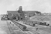
Manufacturing is becoming the largest sector of Nova Scotia's economy. Iron
Iron
Iron is a chemical element with the symbol Fe and atomic number 26. It is a metal in the first transition series. It is the most common element forming the planet Earth as a whole, forming much of Earth's outer and inner core. It is the fourth most common element in the Earth's crust...
and steel
Steel
Steel is an alloy that consists mostly of iron and has a carbon content between 0.2% and 2.1% by weight, depending on the grade. Carbon is the most common alloying material for iron, but various other alloying elements are used, such as manganese, chromium, vanadium, and tungsten...
are produced in Sydney
Sydney
Sydney is the most populous city in Australia and the state capital of New South Wales. Sydney is located on Australia's south-east coast of the Tasman Sea. As of June 2010, the greater metropolitan area had an approximate population of 4.6 million people...
. Also there is food processing (especially of fish), and manufacturing of automobiles, tires, sugar, and construction materials. Halifax is a railroad terminus and a year-round port. There are hydroelectric and tidal power-generating plants. Coast, countryside, and historical sites attract tourists.
Cape Breton Island
Central and Northern
Northumberland StraitNorthumberland Strait
The Northumberland Strait is a strait in the southern part of the Gulf of Saint Lawrence in eastern Canada...
, between Nova Scotia and Prince Edward Island, is 320 kilometres (198.8 mi) long and approximately 14 to 50 km (8.7 to 31.1 mi) wide. The shore line varies from sandstone and sand beaches in the west to granite rocky beaches in the east. The strait's fishing industry is currently in a decline, but lobster
Lobster
Clawed lobsters comprise a family of large marine crustaceans. Highly prized as seafood, lobsters are economically important, and are often one of the most profitable commodities in coastal areas they populate.Though several groups of crustaceans are known as lobsters, the clawed lobsters are most...
remains a commonly-sought species.
The areas north of the Minas Basin
Minas Basin
The Minas Basin is an inlet of the Bay of Fundy and a sub-basin of the Fundy Basin located in Nova Scotia, Canada. It is known for its extremely high tides.- Geography :- Boundary :...
contain extensive coal seams, with numerous mines in production since 1758. There have been several disasters resulting in coal miners being injured or killed, the most famous being the Springhill Mining Disaster
Springhill mining disaster
The term Springhill mining disaster can refer to any of three separate Canadian mining disasters which occurred in 1891, 1956, and 1958 in different mines within the Springhill coalfield, near the town of Springhill in Cumberland County, Nova Scotia....
and the most recent being the Westray Mine Disaster.
Gypsum
Gypsum
Gypsum is a very soft sulfate mineral composed of calcium sulfate dihydrate, with the chemical formula CaSO4·2H2O. It is found in alabaster, a decorative stone used in Ancient Egypt. It is the second softest mineral on the Mohs Hardness Scale...
mining is an industry in central Nova Scotia south of the Minas Basin. Gypsum is a component in drywall
Drywall
Drywall, also known as plasterboard, wallboard or gypsum board is a panel made of gypsum plaster pressed between two thick sheets of paper...
production, which is used as a construction material. Gypsum can be used as a soil conditioner
Soil conditioner
A soil conditioner, also called a soil amendment, is a material added to soil to improve plant growth and health. A conditioner or a combination of conditioners corrects the soil's deficiencies in structure and-or nutrients.-Purpose:...
to improve drainage and fertility of the soil.
Eastern Shore
The area between DartmouthDartmouth, Nova Scotia
Dartmouth founded in 1750, is a community and planning area of the Halifax Regional Municipality, Nova Scotia. Located on the eastern shore of Halifax Harbour, Dartmouth has been nicknamed the City of Lakes after the large number of lakes located in the city.On April 1, 1996, the provincial...
and Cape Breton is sparsely populated. The decline in the fishery has meant an outflow of people to larger urban areas and to other fishing villages in the province. Sheet Harbour, with 900 people, is the largest community.
There is a Fisherman's Life Museum in Jeddore Oyster Ponds. There is trout fishing, and Atlantic salmon serves as sport in rivers along the coast. At Eastern Passage there is a Fishermen's Village tourist attraction with a few stores.
In the Eastern Shore of Nova Scotia the forests grow close to the water. A sawmill was constructed in about 1786. In 1971, Scott Paper
Scott Paper Company
The Scott Paper Company is a USA-based corporation which manufactures mostly paper based consumer products.Scott Paper was founded in 1879 in Philadelphia, Pennsylvania by brothers E. Irvin and Clarence Scott, and is often credited as being the first to market toilet paper sold on a roll...
had their mill destroyed by Hurricane Beth. It was never rebuilt.
South Shore
Lunenburg CountyLunenburg County, Nova Scotia
Lunenburg County is a county located on the South Shore of the Canadian province of Nova Scotia, It ranges from Hubbards to the east and Vogler's Cove to the west.-History:...
's population is about 48,000,of which about 6000 people are Acadian. Many others are related to the first German settlers. It is known for its shipbuilding industry. It is also becoming a tourist destination. The Bluenose
Bluenose
Bluenose was a Canadian fishing and racing schooner from Nova Scotia built in 1921. She was later commemorated by a replica Bluenose II built in 1963. A celebrated racing ship and hard-working fishing vessel, Bluenose became a provincial icon for Nova Scotia as well as important Canadian symbol in...
was built here - the boat that appears on the Canadian dime
Dime (Canadian coin)
In Canada a dime is a coin worth ten cents. It is the smallest of the currently issued Canadian coins. According to the Royal Canadian Mint, the official national term of the coin is the 10 cent piece, but in practice the term dime is universal...
. Highliner Foods has a production facility in Lunenburg.
Mahone Bay
Mahone Bay
Mahone Bay is a bay located on the Atlantic coast of Nova Scotia, Canada along the eastern end of Lunenburg County.Opening south directly onto the Atlantic, its eastern shore is formed by the Aspotogan Peninsula and its western shore is formed by the First Peninsula...
has three churches — Trinity United, St. John Lutheran and St. James Anglican — which have stood by the head of the harbour for over one hundred years. The word "Mahone" derives from mahonne, the French word for the private ships that sailed by the shore of the Mahonne Bay.
Oak Island
Oak Island
Oak Island is a island in Lunenburg County on the south shore of Nova Scotia, Canada. The tree-covered island is one of about 360 small islands in Mahone Bay and rises to a maximum of 35 feet above sea level...
, also in Mahonne, is believed to have treasures buried in it.
Peggys Cove
Peggys Cove, Nova Scotia
Peggys Cove is one of the busiest tourist attractions in Nova Scotia and is a prime attraction on the Lighthouse Trail scenic drive. The community's famous lighthouse marks the eastern entrance of St. Margarets Bay and is officially known as the Peggys Point Lighthouse.Peggys Cove has a classic...
is a small community known for its rocky shore and lighthouses, one of which serves as a Canada Post
Canada Post
Canada Post Corporation, known more simply as Canada Post , is the Canadian crown corporation which functions as the country's primary postal operator...
office during the summer. It is also the location of the Swissair Flight 111
Swissair Flight 111
Swissair Flight 111 was a Swissair McDonnell Douglas MD-11 on a scheduled airline flight from John F. Kennedy International Airport in New York City, United States to Cointrin International Airport in Geneva, Switzerland...
memorial and a sculpture by resident William E. deGarthe
William E. deGarthe
William Edward deGarthe was born in Helsinki, Finland. After emigrating to Canada in 1926, he became a painter and sculptor and lived in Peggys Cove, Nova Scotia.-Biography:...
which serves as a monument to Nova Scotian fishermen.
Nova Scotia's provincial berry and flower
On January 11, 1996, the House of Assembly declared the wild blueberry the Provincial Berry of Nova Scotia. The blueberry mainly grows in northeastern North America.Forests cover most of Nova Scotia. In these woodlands, often nearly hidden with fallen leaves, grows the mayflower, also known as the trailing arbutus (Epigaea repens). In 1901 the mayflower was declared to be the Provincial Flower of Nova Scotia by the provincial legislature.
Climate
Located on the east coast of Canada, Nova Scotia is almose entirely surrounded by the sea, which heavily influences the climate. Due to the ocean's moderating effect Nova Scotia is the warmest province in Canada. Nova Scotia's maritime climate is influenced by the cold air masses passing from the centre of Canada and the warm air masses from the Atlantic Ocean.Because it juts out into the Atlantic, Nova Scotia is prone to tropical storms and hurricanes in the summer and autumn.
See also
- List of highest points of Canadian provinces and territories
- List of areas disputed by the United States and Canada
- Extreme communities of CanadaExtreme communities of CanadaThis is a list of the extreme communities in Canada and its provinces and territories. They are further east, north, south or west than any other community, though they are generally not further than the extreme points of Canadian provinces. The record latitude or longitude is given.*Lloydminster...
- Canadian RockiesCanadian RockiesThe Canadian Rockies comprise the Canadian segment of the North American Rocky Mountains range. They are the eastern part of the Canadian Cordillera, extending from the Interior Plains of Alberta to the Rocky Mountain Trench of British Columbia. The southern end borders Idaho and Montana of the USA...
- Canadian GeographicCanadian GeographicCanadian Geographic is the bimonthly magazine of the Royal Canadian Geographical Society . It was first published in May 1930 under the name Canadian Geographical Journal. The society's objective was to produce a popular magazine dealing primarily with Canadian geography...