

Geography of Nigeria
Encyclopedia
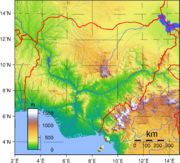
Nigeria
is a country in West Africa
. Nigeria shares land border
s with the Republic of Benin
in the west, Chad
and Cameroon
in the east, and Niger
in the north. Its coast lies on the Gulf of Guinea
in the south and it borders Lake Chad
to the northeast. Noted geographical features in Nigeria include the Adamawa highlands, Mambilla Plateau
, Jos Plateau
, Obudu Plateau
, the Niger River
, River Benue and Niger Delta
. The country's geographic coordinates are 10°00′N 8°00′E.
 The total area of Nigeria is 923,768 km². 910,768 km² of that is land, while water takes up 13 000 km². Nigeria's total boundaries are 4 047 km in length. The countries it borders account for most of this. The border with Benin
is 773 km, that with Cameroon
is 1,690 km, Chad
's is 87 km, and Niger
's is 1,497 km. Nigeria's coastline is 853 km.
Nigeria makes the following maritime
claims:
continental shelf
:
200-m depth or to the depth of exploitation
exclusive economic zone:
200 nmi (370.4 km; 230.2 mi)
territorial sea:
12 nmi (22.2 km; 13.8 mi)
, making the country a tropical country with a tropical climate type where seasons are damp and very humid.
Nigeria is affected by four climate types
; these climate types are distinguishable, as one moves from the southern part of Nigeria
to the northern part of Nigeria
through Nigeria's middle belt
.
, designated by the Köppen climate classification
as "Af", is found in the southern part of the country. This climate is influenced by the monsoon
s originating from the South Atlantic ocean
, which is brought into the country by the (maritime tropical) MT airmass
, a warm moist sea to land seasonal wind.Its warmth and high humidity gives it a strong tendency to ascend and produce copious rainfall, which is a result of the condensation of water vapour in the rapidly rising air.
The Tropical rainforest climate has a very small temperature range.The temperature ranges are almost constant throughout the year, for example, Warri town in the southern part of Nigeria, records a maximum of 28 °C (82.4 °F) for its hottest month while its lowest temperature is 26 °C (78.8 °F) in its coldest month. The temperature difference of Warri town is not more than 2 °C (5 °F).
The southern part of Nigeria experiences heavy and abundant rainfall. These storms are usually convectional
in nature due to the regions proximity, to the equatorial belt
. The annual rainfall received in this region is very high, usually above the 2000 mm (78.7 in) rainfall totals giving for tropical rainforest climates worldwide. Over 4000 mm (157.5 in) of rainfall is received in the coastal region of Nigeria around the Niger delta
area. Bonny town found in the coastal region of the Niger delta area in southern Nigeria receives well over 4000 mm (157.5 in) of rainfall annually. The rest of the southeast receives between 2,000 and 3000 mm (118.1 in) of rain per year.
The southern region of Nigeria experiences a double rainfall maxima characterised by two high rainfall peaks, with a short dry season and a longer dry season falling between and after each peaks.
The first rainy season begins around March and last to the end of July with a peak in June,this rainy season is followed by a short dry break in August known as the August break which is a short dry season lasting for two to three weeks in August.This break is broken by the Short rainy season starting around early September and lasting to Mid October with a peak period at the end of September.The ending of the short rainy season in October is followed by Long Dry Season.This period starts from late October and lasts till early March with peak dry conditions between early December and late February.
The Tropical savanna climate or Tropical wet and dry climate
, is extensive in area and covers most of Western Nigeria to central Nigeria beginning from the Tropical rainforest climate boundary in southern Nigeria to the central
part of Nigeria, where it exerts enormous influence on the region.
This climate, the tropical savanna climate exhibits a well marked Rainy season and a dry season with a single peak known as the summer maximum due to its distance from the equator. Temperatures are above 18 °C (64.4 °F) throughout the year. Abuja
, Nigeria's capital city found in central Nigeria, has a temperature range of 18.45 °C (65.2 °F) to 36.05 °C (96.9 °F), and an annual rainfall of about 1500 mm (59.1 in) with a single rainfall maxima in September.
The single Dry season experienced in this climate, the tropical savanna climate in central Nigeria beginning from December to march, is hot and dry with the Harmattan
wind, a continental tropical(CT) airmass laden with dust from the Sahara
Desert prevailing throughout this period.
With the Intertropical Convergence Zone (ITCZ)
swinging northward over West Africa from the southern hemisphere
in April, heavy showers coming from pre-monsoonal convective clouds mainly in the form of squall lines also known as the north easterlies formed mainly as a result of the interactions of the two dominant airmasses in Nigeria known as the Maritime tropical(south westerlies) and the Continental tropical(north easterlies), begins in central Nigeria while the Monsoons from the south atlantic ocean arrives in central Nigeria in July bringing with it high humidity, heavy cloud cover and heavy rainfall which can be daily occurrence lasting till September when the monsoons gradually begin retreating southward to the southern part of Nigeria.Rainfall totals in central Nigeria varies from 1100 mm (43.3 in) in the lowlands of the river Niger Benue trough to over 2000 mm (78.7 in) along the south western escarpment of the Jos Plateau
and the southern Kaduna highlands which extents into Nigeria's Federal Capital Territory, just north of Abuja city, due to orographic activities on the highlands in central Nigeria.
The Sahel Climate or Tropical dry climate
, is the predominant climate type in the northern part of Nigeria. Annual rainfall totals are lower compared to the southern and central part of Nigeria.
Rainy season in the northern part of Nigeria last for only three to four months (June–September). The rest of the year is hot and dry with temperatures climbing as high as 40 °C (104 °F) .
Alpine climate or highland climate or mountain climate
, are found on highlands regions in Nigeria. Highlands with the alpine climate in Nigeria, are well over 1520 metres (4,987 ft) above sea level. Due to their location in the tropics, this elevation is high enough to reach the temperate climate line in the tropics thereby giving the highlands, mountains and the plateau regions
standing above this height, a cool mountain climate.
The dry season is accompanied by a dust laden airmass from the Sahara Desert, locally known as Harmattan
, or by its main name, The Tropical Continental (CT) airmass , while the rainy season is heavily influenced by an airmass originating from the south atlantic ocean, locally known as the south west wind, or by its main name, The Tropical Maritime (MT) airmass. These two major wind systems in Nigeria, are known as the trade winds.
The northward retreat of the tropical continental airmass (CT), is caused by the sun's northward shift from the tropic of capricorn
in the southern hemisphere
to the tropic of cancer
in the northern hemisphere
. This shift begins from February and ends in June, when the sun is fully overhead, at the tropic of cancer
in the northern hemisphere.
During this northward migration of the sun as a result of the earth tilting along its axis, the sun crosses the equator (around March), moving over west Africa at this time on its journey to the northern hemisphere. West Africa comes directly under the sun at this time. The sun is overhead throughout west Africa and over Nigeria during this period of the sun's northward migration to the tropic of cancer
in the northern hemisphere.
The whole of West Africa is heated intensely as result of the increased insulation
received from the sun being overhead over west Africa. Temperatures can climb as high as 35 °C (95 °F) over west Africa during this time. Temperatures in the northern part of Nigeria can go as high as 48 °C (118.4 °F) in cities like Maiduguri.
The high temperatures coupled with an increase in insolation causes a region of low pressure to develop over west Africa and Nigeria (between March to May). The Tropical continental airmass (CT) from the Sahara Desert in the northern part of West Africa, is weakened due to the overheating of the land surface in west Africa and Nigeria at this time. The Tropical continental airmass (CT) begins to retreat northwards to the Sahara Desert due to massive heating of the land which transfers heat in the form of convection into the Tropical continental airmass (CT) which constitutes the main layer of air above the land. This transfer of heat in the Tropical continental airmass (CT) in turn, causes the wind to expand and become lighter as this is the normal behaviour for winds moving above intensely heated grounds.
The Tropical continental airmass (CT) loses its strength as a major airmass in the region of west Africa and over Nigeria at this time (around February in the southern part of Nigeria to June in northern Nigeria) and begins to retreat coupled with the rising of air in form of convection within this airmass (Tropical continental airmass (CT)), further weakening the dominance of the wind over west Africa and Nigeria.
The Tropical continental airmass (CT) finally retreats from most part of Nigeria, and the West African atmosphere
around April to May, leaving an empty atmosphere over Nigeria. The sun's rays enters into the atmosphere of Nigeria more intense than it does during the presence of the Tropical continental airmass, which contained dust (in form of haze) that reduced the intensity of the sun. The overheating of the west Africa land mass and Nigeria in particular creates a low pressure region over west Africa and Nigeria. This low pressure zone attracts the Tropical Maritime Airmass (MT) from the south atlantic ocean since areas of low pressures experiences inward blowing winds because winds are moving air blowing outwards from regions of high pressure to regions of low pressure.
The Tropical Maritime Airmass is a warm humid and unstable trade wind due to its warmth. Convectional currents are easily set up within the airmass whenever there is little instability in the airmass as a result of a slight to a very high orographic uplift in mountainous regions like the obudu plateau
or the heating of the land which can trigger the formation of cumulonimbus cloud leading to thunderstorms within the airmass.
During the dominance of the Tropical Maritime Airmass (MT) in the rainy season of Nigeria, mornings are bright and sunny, the sun's heating of the land in the mornings and afternoons sets up convectional currents, these currents rise vertically and cumulonimbus clouds are formed, by afternoons to evenings, torrential downpour follows.
The Easterly wave or the African easterly waves is another major contributor of rainfall during the summer monsoons months of May to September in Nigeria.
The nature of this waves changes at about the 15 degrees line
.The waves that pass south of this line carry moisture and create convection that leads to rain clouds. Nigeria's northern end is south of the 15 degrees line at about 14 degrees. Nigeria's location in the wetter part of the easterly waves south of the 15 degree line creates wetter climatic conditions for Nigeria especially during the monsoons.
, is a wind originating from North Africa
which crosses the Sahara Desert into west Africa to Nigeria. This airmass dominates Nigeria's climate during the dry season from December to March.
The Tropical continental airmass is dusty and creates a haze within the atmosphere of west Africa and Nigeria when it predominates. The haze is as a result of the dust within the airmass limiting visibility and blocking much of the sun's rays from reaching the earth.
The airmass makes life difficult as a result of low visibility which hampers transportation.
The dust haze creates an almost desert conditions in the country during the dominance of the Tropical continental airmass (the harmattan). But its coming brings some relief to farmers since the low humidity present in the air quickens the drying of their crops.
The rainy season of Nigeria brings in cooler weather to the country as a result of an increased cloud cover that acts as a blockage to the intense sunshine of the tropics by blocking much of the suns rays in the rainy season; this in turn cools the land, and the winds above the ground remains cool thereby making for cooler temperatures during the rainy season. But afternoons in the rainy season can be hot and humid, a feature of tropical climates.
The dry season of Nigeria is a period of little cloud cover in the southern part of Nigeria to virtually no cloud cover in the northern part of Nigeria. The sun shines through the atmosphere with little obstructions from the clear skies making the dry season in Nigeria a period of warm weather conditions.
In the middle of the dry season around December, a dusty wind from the Sahara Desert called the harmattan enters Nigeria from the northeastern part of the country blocking sun rays partially from shining and also creating haze in the atmosphere, this activities of the wind lowers temperatures considerably saving inhabitants for sometime, from the scorching heat that would have occurred as a result of clearer skies during the dry season. But with the withdrawal of this wind around March to April following the unset of the rainy season, temperatures can go as high as 44 °C (111.2 °F) in some parts of Nigeria.
Semi temperate weather conditions prevail on the highlands in central Nigeria
above 1200 metres (3,937 ft) above sea level, namely the Jos Plateau
. Temperatures on the Jos plateau ranges between 21°C to 25°C which are cool all year round.
Temperate
weather conditions occur on the highlands along the Nigeria Cameroon
border, in the eastern part of Nigeria. Highlands in these region attain an average height of more than 1524 m (5,000 ft) to some standing above 2000 metres (6,562 ft) above sea level. The climate on these highlands is temperate all year round. The major highlands in this region are the Obudu Plateau
above 1584 m (5,197 ft) , Mambilla Plateau
above 1524 m (5,000 ft) and Mt Chappal Waddi
above 2000 m (6,562 ft).
 Nigeria's most expansive topographical region is that of the valleys of the Niger
and Benue River
valleys (which merge into each other and form a "y" shaped confluence
at Lokoja
). Plains rise to the north of the valleys. To the southwest of the Niger there is "rugged" highland
, and to the southeast of the Benue hills and mountains are found all the way to the border with Cameroon
. Coastal plain
s are found in both the southwest and the southeast.
is located in the southern part of Nigeria. It is one of the world's largest arcuate
fan-shaped river delta
s.
The riverine area of the Niger Delta is a coastal belt of swamps bordering the Atlantic ocean
. The swamps are vegetated tidal flats formed by a reticulate pattern of interconnected meandering creek
s and distributaries of the River Niger.
of the Niger Delta
consist mainly of forest
swamps. The forest are of two types, nearest the sea
is a belt of saline/brackish Mangrove
swamp separated from the sea by sand beach ridges within the mangrove swamp. Numerous sandy islands occur with fresh water vegetation. Fresh water
swamps gradually supersede the mangrove on the landward side. About 70% of Nigeria's crude oil and gas
production is from the area.
.
. Annual rainfall totals vary from 2400 to over 4000 millimeters.
Niger Delta cities and their annually rainfall totals in millimeters:
 Nigeria is covered by three types of vegetation: forests (where there is significant tree cover), savannahs (insignificant tree cover, with grasses and flowers located between trees), and montane
land. (The latter is the least common, and is mainly found in the mountains near the Cameroonian border.) Both the forest zone and the savannah zone are divided into three parts.
Some of the forest zone's most southerly portion, especially around the Niger River
and Cross River
deltas, is mangrove
swamp (see Central African mangroves
). North of this is fresh water swamp, containing different vegetation from the salt water mangrove swamps, and north of that is rain forest.
The savannah zone's three categories are divided into mm' Guinean forest-savanna mosaic
, made up of plains of tall grass which are interrupted by trees, the most common across the country; Sudan savannah, similar but with shorter grasses and shorter trees; and Sahel
savannah patches of grass and sand, found in the northeast.
(see petroleum in Nigeria
), tin
, columbite
, iron ore, coal
, limestone
, lead
, zinc
, natural gas
, hydropower
, and arable land
.
, the points that are farther north, south, east or west than any other location.
Nigeria
Nigeria , officially the Federal Republic of Nigeria, is a federal constitutional republic comprising 36 states and its Federal Capital Territory, Abuja. The country is located in West Africa and shares land borders with the Republic of Benin in the west, Chad and Cameroon in the east, and Niger in...
is a country in West Africa
West Africa
West Africa or Western Africa is the westernmost region of the African continent. Geopolitically, the UN definition of Western Africa includes the following 16 countries and an area of approximately 5 million square km:-Flags of West Africa:...
. Nigeria shares land border
Border
Borders define geographic boundaries of political entities or legal jurisdictions, such as governments, sovereign states, federated states and other subnational entities. Some borders—such as a state's internal administrative borders, or inter-state borders within the Schengen Area—are open and...
s with the Republic of Benin
Benin
Benin , officially the Republic of Benin, is a country in West Africa. It borders Togo to the west, Nigeria to the east and Burkina Faso and Niger to the north. Its small southern coastline on the Bight of Benin is where a majority of the population is located...
in the west, Chad
Chad
Chad , officially known as the Republic of Chad, is a landlocked country in Central Africa. It is bordered by Libya to the north, Sudan to the east, the Central African Republic to the south, Cameroon and Nigeria to the southwest, and Niger to the west...
and Cameroon
Cameroon
Cameroon, officially the Republic of Cameroon , is a country in west Central Africa. It is bordered by Nigeria to the west; Chad to the northeast; the Central African Republic to the east; and Equatorial Guinea, Gabon, and the Republic of the Congo to the south. Cameroon's coastline lies on the...
in the east, and Niger
Niger
Niger , officially named the Republic of Niger, is a landlocked country in Western Africa, named after the Niger River. It borders Nigeria and Benin to the south, Burkina Faso and Mali to the west, Algeria and Libya to the north and Chad to the east...
in the north. Its coast lies on the Gulf of Guinea
Gulf of Guinea
The Gulf of Guinea is the northeasternmost part of the tropical Atlantic Ocean between Cape Lopez in Gabon, north and west to Cape Palmas in Liberia. The intersection of the Equator and Prime Meridian is in the gulf....
in the south and it borders Lake Chad
Lake Chad
Lake Chad is a historically large, shallow, endorheic lake in Africa, whose size has varied over the centuries. According to the Global Resource Information Database of the United Nations Environment Programme, it shrank as much as 95% from about 1963 to 1998; yet it also states that "the 2007 ...
to the northeast. Noted geographical features in Nigeria include the Adamawa highlands, Mambilla Plateau
Mambilla Plateau
The Mambilla Plateau is a highland region, found in Taraba State of Nigeria. This highland region, is the northern continuation of the Bamenda Highlands of Cameroon....
, Jos Plateau
Jos Plateau
The Jos Plateau is a plateau located near the center of Nigeria. It covers 8600 km² and is bounded by 300-600 meter escarpments around much of its circumference. With an average altitude of 1280 metres and its highest point is Shere Hills 1829 meters...
, Obudu Plateau
Obudu Plateau
Obudu Plateau is a montane grassland plateau found on the Oshie Ridge of the Sankwala Mountain range, in Cross River state,south east of Nigeria. The plateau is found in Obanliku local government area of the Cross river state...
, the Niger River
Niger River
The Niger River is the principal river of western Africa, extending about . Its drainage basin is in area. Its source is in the Guinea Highlands in southeastern Guinea...
, River Benue and Niger Delta
Niger Delta
The Niger Delta, the delta of the Niger River in Nigeria, is a densely populated region sometimes called the Oil Rivers because it was once a major producer of palm oil...
. The country's geographic coordinates are 10°00′N 8°00′E.
Area and boundaries
Geography of Benin
Benin, a narrow, key-shaped, north-south strip of land in West Africa, lies between the Equator and the Tropic of Cancer. Benin's latitude ranges from 6°30′ N to 12°30′ N and its longitude from 1° E to 3°40′ E. Benin is bounded by Togo to the west, Burkina Faso and Niger to the...
is 773 km, that with Cameroon
Geography of Cameroon
At , Cameroon is the world's 54th-largest country. It is comparable in size to Papua New Guinea, and somewhat larger than the U.S. state of California...
is 1,690 km, Chad
Geography of Chad
Chad is a land-locked country in north central Africa measuring , roughly three times the size of California. Most of its ethnically and linguistically diverse population lives in the south, with densities ranging from 54 persons per square kilometers in the Logone River basin to 0.1 persons in the...
's is 87 km, and Niger
Geography of Niger
Niger is a landlocked nation in West Africa located along the border between the Sahara and Sub-Saharan regions. Its geographic coordinates are a longitude of 16°N and a latitude off 8°E. Its area is 1.267 million square kilometers, of which 1 266 700 km² is land and 300 km²...
's is 1,497 km. Nigeria's coastline is 853 km.
Nigeria makes the following maritime
Sea
A sea generally refers to a large body of salt water, but the term is used in other contexts as well. Most commonly, it means a large expanse of saline water connected with an ocean, and is commonly used as a synonym for ocean...
claims:
continental shelf
Continental shelf
The continental shelf is the extended perimeter of each continent and associated coastal plain. Much of the shelf was exposed during glacial periods, but is now submerged under relatively shallow seas and gulfs, and was similarly submerged during other interglacial periods. The continental margin,...
:
200-m depth or to the depth of exploitation
exclusive economic zone:
200 nmi (370.4 km; 230.2 mi)
territorial sea:
12 nmi (22.2 km; 13.8 mi)
Climate
Nigeria is found in the TropicsTropics
The tropics is a region of the Earth surrounding the Equator. It is limited in latitude by the Tropic of Cancer in the northern hemisphere at approximately N and the Tropic of Capricorn in the southern hemisphere at S; these latitudes correspond to the axial tilt of the Earth...
, making the country a tropical country with a tropical climate type where seasons are damp and very humid.
Nigeria is affected by four climate types
Köppen climate classification
The Köppen climate classification is one of the most widely used climate classification systems. It was first published by Crimea German climatologist Wladimir Köppen in 1884, with several later modifications by Köppen himself, notably in 1918 and 1936...
; these climate types are distinguishable, as one moves from the southern part of Nigeria
Southern Nigeria Protectorate
Southern Nigeria was a British protectorate in the coastal areas of modern-day Nigeria, formed in 1900 from union of the Niger Coast Protectorate with territories chartered by the Royal Niger Company below Lokoja on the Niger River....
to the northern part of Nigeria
Northern Nigeria
Northern Nigeria is a geographical region of Nigeria. It is more arid and less densely populated than the south. The people are largely Muslim, and many are Hausa...
through Nigeria's middle belt
Middle Belt
The Middle Belt is a human geographical term designating the region of central Nigeria populated largely by minority ethnic groups and stretching across the country longitudinally. The Middle Belt is indeterminate in that it lacks designated "borders" and is charactized by a heterogeneity and...
.
Climate types found in Nigeria
The Tropical rainforest climate or the Equatorial monsoonTropical rainforest climate
A tropical rainforest climate, also known as an equatorial climate, is a tropical climate usually found along the equator...
, designated by the Köppen climate classification
Köppen climate classification
The Köppen climate classification is one of the most widely used climate classification systems. It was first published by Crimea German climatologist Wladimir Köppen in 1884, with several later modifications by Köppen himself, notably in 1918 and 1936...
as "Af", is found in the southern part of the country. This climate is influenced by the monsoon
Monsoon
Monsoon is traditionally defined as a seasonal reversing wind accompanied by corresponding changes in precipitation, but is now used to describe seasonal changes in atmospheric circulation and precipitation associated with the asymmetric heating of land and sea...
s originating from the South Atlantic ocean
Atlantic Ocean
The Atlantic Ocean is the second-largest of the world's oceanic divisions. With a total area of about , it covers approximately 20% of the Earth's surface and about 26% of its water surface area...
, which is brought into the country by the (maritime tropical) MT airmass
Airmass
In astronomy, air mass is the optical path length through Earth’s atmosphere for light from a celestial source. As it passes through the atmosphere, light is attenuated by scattering and absorption; the more atmosphere through which it passes, the greater the attenuation. Consequently, celestial...
, a warm moist sea to land seasonal wind.Its warmth and high humidity gives it a strong tendency to ascend and produce copious rainfall, which is a result of the condensation of water vapour in the rapidly rising air.
The Tropical rainforest climate has a very small temperature range.The temperature ranges are almost constant throughout the year, for example, Warri town in the southern part of Nigeria, records a maximum of 28 °C (82.4 °F) for its hottest month while its lowest temperature is 26 °C (78.8 °F) in its coldest month. The temperature difference of Warri town is not more than 2 °C (5 °F).
The southern part of Nigeria experiences heavy and abundant rainfall. These storms are usually convectional
Precipitation (meteorology)
In meteorology, precipitation In meteorology, precipitation In meteorology, precipitation (also known as one of the classes of hydrometeors, which are atmospheric water phenomena is any product of the condensation of atmospheric water vapor that falls under gravity. The main forms of precipitation...
in nature due to the regions proximity, to the equatorial belt
Equator
An equator is the intersection of a sphere's surface with the plane perpendicular to the sphere's axis of rotation and containing the sphere's center of mass....
. The annual rainfall received in this region is very high, usually above the 2000 mm (78.7 in) rainfall totals giving for tropical rainforest climates worldwide. Over 4000 mm (157.5 in) of rainfall is received in the coastal region of Nigeria around the Niger delta
Niger Delta
The Niger Delta, the delta of the Niger River in Nigeria, is a densely populated region sometimes called the Oil Rivers because it was once a major producer of palm oil...
area. Bonny town found in the coastal region of the Niger delta area in southern Nigeria receives well over 4000 mm (157.5 in) of rainfall annually. The rest of the southeast receives between 2,000 and 3000 mm (118.1 in) of rain per year.
The southern region of Nigeria experiences a double rainfall maxima characterised by two high rainfall peaks, with a short dry season and a longer dry season falling between and after each peaks.
The first rainy season begins around March and last to the end of July with a peak in June,this rainy season is followed by a short dry break in August known as the August break which is a short dry season lasting for two to three weeks in August.This break is broken by the Short rainy season starting around early September and lasting to Mid October with a peak period at the end of September.The ending of the short rainy season in October is followed by Long Dry Season.This period starts from late October and lasts till early March with peak dry conditions between early December and late February.
The Tropical savanna climate or Tropical wet and dry climate
Tropical savanna climate
Tropical savanna climate or tropical wet and dry climate is a type of climate that corresponds to the Köppen climate classification categories "Aw" and '"As."...
, is extensive in area and covers most of Western Nigeria to central Nigeria beginning from the Tropical rainforest climate boundary in southern Nigeria to the central
Middle Belt
The Middle Belt is a human geographical term designating the region of central Nigeria populated largely by minority ethnic groups and stretching across the country longitudinally. The Middle Belt is indeterminate in that it lacks designated "borders" and is charactized by a heterogeneity and...
part of Nigeria, where it exerts enormous influence on the region.
This climate, the tropical savanna climate exhibits a well marked Rainy season and a dry season with a single peak known as the summer maximum due to its distance from the equator. Temperatures are above 18 °C (64.4 °F) throughout the year. Abuja
Abuja
Abuja is the capital city of Nigeria. It is located in the centre of Nigeria, within the Federal Capital Territory . Abuja is a planned city, and was built mainly in the 1980s. It officially became Nigeria's capital on 12 December 1991, replacing Lagos...
, Nigeria's capital city found in central Nigeria, has a temperature range of 18.45 °C (65.2 °F) to 36.05 °C (96.9 °F), and an annual rainfall of about 1500 mm (59.1 in) with a single rainfall maxima in September.
The single Dry season experienced in this climate, the tropical savanna climate in central Nigeria beginning from December to march, is hot and dry with the Harmattan
Harmattan
The Harmattan is a dry and dusty West African trade wind. It blows south from the Sahara into the Gulf of Guinea between the end of November and the middle of March...
wind, a continental tropical(CT) airmass laden with dust from the Sahara
Sahara
The Sahara is the world's second largest desert, after Antarctica. At over , it covers most of Northern Africa, making it almost as large as Europe or the United States. The Sahara stretches from the Red Sea, including parts of the Mediterranean coasts, to the outskirts of the Atlantic Ocean...
Desert prevailing throughout this period.
With the Intertropical Convergence Zone (ITCZ)
Intertropical Convergence Zone
The Intertropical Convergence Zone , known by sailors as The Doldrums, is the area encircling the earth near the equator where winds originating in the northern and southern hemispheres come together....
swinging northward over West Africa from the southern hemisphere
Hemisphere
Hemisphere may refer to:*Half of a sphereAs half of the Earth:*Any half of the Earth, see Hemispheres of the Earth, see:...
in April, heavy showers coming from pre-monsoonal convective clouds mainly in the form of squall lines also known as the north easterlies formed mainly as a result of the interactions of the two dominant airmasses in Nigeria known as the Maritime tropical(south westerlies) and the Continental tropical(north easterlies), begins in central Nigeria while the Monsoons from the south atlantic ocean arrives in central Nigeria in July bringing with it high humidity, heavy cloud cover and heavy rainfall which can be daily occurrence lasting till September when the monsoons gradually begin retreating southward to the southern part of Nigeria.Rainfall totals in central Nigeria varies from 1100 mm (43.3 in) in the lowlands of the river Niger Benue trough to over 2000 mm (78.7 in) along the south western escarpment of the Jos Plateau
Jos Plateau
The Jos Plateau is a plateau located near the center of Nigeria. It covers 8600 km² and is bounded by 300-600 meter escarpments around much of its circumference. With an average altitude of 1280 metres and its highest point is Shere Hills 1829 meters...
and the southern Kaduna highlands which extents into Nigeria's Federal Capital Territory, just north of Abuja city, due to orographic activities on the highlands in central Nigeria.
The Sahel Climate or Tropical dry climate
Sahel
The Sahel is the ecoclimatic and biogeographic zone of transition between the Sahara desert in the North and the Sudanian Savannas in the south.It stretches across the North African continent between the Atlantic Ocean and the Red Sea....
, is the predominant climate type in the northern part of Nigeria. Annual rainfall totals are lower compared to the southern and central part of Nigeria.
Rainy season in the northern part of Nigeria last for only three to four months (June–September). The rest of the year is hot and dry with temperatures climbing as high as 40 °C (104 °F) .
Alpine climate or highland climate or mountain climate
Alpine climate
Alpine climate is the average weather for a region above the tree line. This climate is also referred to as mountain climate or highland climate....
, are found on highlands regions in Nigeria. Highlands with the alpine climate in Nigeria, are well over 1520 metres (4,987 ft) above sea level. Due to their location in the tropics, this elevation is high enough to reach the temperate climate line in the tropics thereby giving the highlands, mountains and the plateau regions
Plateau
In geology and earth science, a plateau , also called a high plain or tableland, is an area of highland, usually consisting of relatively flat terrain. A highly eroded plateau is called a dissected plateau...
standing above this height, a cool mountain climate.
Seasons
Nigeria, like the rest of West Africa and other tropical lands, has only two seasons. These are the Dry season and the Rainy season.The dry season is accompanied by a dust laden airmass from the Sahara Desert, locally known as Harmattan
Harmattan
The Harmattan is a dry and dusty West African trade wind. It blows south from the Sahara into the Gulf of Guinea between the end of November and the middle of March...
, or by its main name, The Tropical Continental (CT) airmass , while the rainy season is heavily influenced by an airmass originating from the south atlantic ocean, locally known as the south west wind, or by its main name, The Tropical Maritime (MT) airmass. These two major wind systems in Nigeria, are known as the trade winds.
Tropical Maritime Airmass
The Tropical Maritime Airmass (MT) is responsible for Nigeria's rainy season. This wind (the Tropical Maritime Airmass) invades the country from February in the southern part of Nigeria while it takes longer for the wind to fully cover the whole of the country, reaching the northern part of Nigeria in June. Its invasion is as a result of the northward retreat, of the tropical continental airmass (CT) known as the harmattan.The northward retreat of the tropical continental airmass (CT), is caused by the sun's northward shift from the tropic of capricorn
Tropic of Capricorn
The Tropic of Capricorn, or Southern tropic, marks the most southerly latitude on the Earth at which the Sun can be directly overhead. This event occurs at the December solstice, when the southern hemisphere is tilted towards the Sun to its maximum extent.Tropic of Capricorn is one of the five...
in the southern hemisphere
Southern Hemisphere
The Southern Hemisphere is the part of Earth that lies south of the equator. The word hemisphere literally means 'half ball' or "half sphere"...
to the tropic of cancer
Tropic of Cancer
The Tropic of Cancer, also referred to as the Northern tropic, is the circle of latitude on the Earth that marks the most northerly position at which the Sun may appear directly overhead at its zenith...
in the northern hemisphere
Northern Hemisphere
The Northern Hemisphere is the half of a planet that is north of its equator—the word hemisphere literally means “half sphere”. It is also that half of the celestial sphere north of the celestial equator...
. This shift begins from February and ends in June, when the sun is fully overhead, at the tropic of cancer
Tropic of Cancer
The Tropic of Cancer, also referred to as the Northern tropic, is the circle of latitude on the Earth that marks the most northerly position at which the Sun may appear directly overhead at its zenith...
in the northern hemisphere.
During this northward migration of the sun as a result of the earth tilting along its axis, the sun crosses the equator (around March), moving over west Africa at this time on its journey to the northern hemisphere. West Africa comes directly under the sun at this time. The sun is overhead throughout west Africa and over Nigeria during this period of the sun's northward migration to the tropic of cancer
Tropic of Cancer
The Tropic of Cancer, also referred to as the Northern tropic, is the circle of latitude on the Earth that marks the most northerly position at which the Sun may appear directly overhead at its zenith...
in the northern hemisphere.
The whole of West Africa is heated intensely as result of the increased insulation
Insulation
Insulation means:* Building insulation, added to buildings for comfort and energy efficiency* Soundproofing, also known as acoustic insulation, any means of reducing the intensity of sound...
received from the sun being overhead over west Africa. Temperatures can climb as high as 35 °C (95 °F) over west Africa during this time. Temperatures in the northern part of Nigeria can go as high as 48 °C (118.4 °F) in cities like Maiduguri.
The high temperatures coupled with an increase in insolation causes a region of low pressure to develop over west Africa and Nigeria (between March to May). The Tropical continental airmass (CT) from the Sahara Desert in the northern part of West Africa, is weakened due to the overheating of the land surface in west Africa and Nigeria at this time. The Tropical continental airmass (CT) begins to retreat northwards to the Sahara Desert due to massive heating of the land which transfers heat in the form of convection into the Tropical continental airmass (CT) which constitutes the main layer of air above the land. This transfer of heat in the Tropical continental airmass (CT) in turn, causes the wind to expand and become lighter as this is the normal behaviour for winds moving above intensely heated grounds.
The Tropical continental airmass (CT) loses its strength as a major airmass in the region of west Africa and over Nigeria at this time (around February in the southern part of Nigeria to June in northern Nigeria) and begins to retreat coupled with the rising of air in form of convection within this airmass (Tropical continental airmass (CT)), further weakening the dominance of the wind over west Africa and Nigeria.
The Tropical continental airmass (CT) finally retreats from most part of Nigeria, and the West African atmosphere
Atmosphere
An atmosphere is a layer of gases that may surround a material body of sufficient mass, and that is held in place by the gravity of the body. An atmosphere may be retained for a longer duration, if the gravity is high and the atmosphere's temperature is low...
around April to May, leaving an empty atmosphere over Nigeria. The sun's rays enters into the atmosphere of Nigeria more intense than it does during the presence of the Tropical continental airmass, which contained dust (in form of haze) that reduced the intensity of the sun. The overheating of the west Africa land mass and Nigeria in particular creates a low pressure region over west Africa and Nigeria. This low pressure zone attracts the Tropical Maritime Airmass (MT) from the south atlantic ocean since areas of low pressures experiences inward blowing winds because winds are moving air blowing outwards from regions of high pressure to regions of low pressure.
The Tropical Maritime Airmass is a warm humid and unstable trade wind due to its warmth. Convectional currents are easily set up within the airmass whenever there is little instability in the airmass as a result of a slight to a very high orographic uplift in mountainous regions like the obudu plateau
Obudu Plateau
Obudu Plateau is a montane grassland plateau found on the Oshie Ridge of the Sankwala Mountain range, in Cross River state,south east of Nigeria. The plateau is found in Obanliku local government area of the Cross river state...
or the heating of the land which can trigger the formation of cumulonimbus cloud leading to thunderstorms within the airmass.
During the dominance of the Tropical Maritime Airmass (MT) in the rainy season of Nigeria, mornings are bright and sunny, the sun's heating of the land in the mornings and afternoons sets up convectional currents, these currents rise vertically and cumulonimbus clouds are formed, by afternoons to evenings, torrential downpour follows.
The Easterly wave or the African easterly waves is another major contributor of rainfall during the summer monsoons months of May to September in Nigeria.
The nature of this waves changes at about the 15 degrees line
Latitude
In geography, the latitude of a location on the Earth is the angular distance of that location south or north of the Equator. The latitude is an angle, and is usually measured in degrees . The equator has a latitude of 0°, the North pole has a latitude of 90° north , and the South pole has a...
.The waves that pass south of this line carry moisture and create convection that leads to rain clouds. Nigeria's northern end is south of the 15 degrees line at about 14 degrees. Nigeria's location in the wetter part of the easterly waves south of the 15 degree line creates wetter climatic conditions for Nigeria especially during the monsoons.
Tropical continental airmass
The Tropical Continental Airmass (CT) locally known as the harmattanHarmattan
The Harmattan is a dry and dusty West African trade wind. It blows south from the Sahara into the Gulf of Guinea between the end of November and the middle of March...
, is a wind originating from North Africa
North Africa
North Africa or Northern Africa is the northernmost region of the African continent, linked by the Sahara to Sub-Saharan Africa. Geopolitically, the United Nations definition of Northern Africa includes eight countries or territories; Algeria, Egypt, Libya, Morocco, South Sudan, Sudan, Tunisia, and...
which crosses the Sahara Desert into west Africa to Nigeria. This airmass dominates Nigeria's climate during the dry season from December to March.
The Tropical continental airmass is dusty and creates a haze within the atmosphere of west Africa and Nigeria when it predominates. The haze is as a result of the dust within the airmass limiting visibility and blocking much of the sun's rays from reaching the earth.
Effects of the tropical continental airmass
The airmass has no ability of forming rain due to low humidity within the airmass, since it crosses the Sahara Desert, it picks up dust instead of water thereby creating little chances for rainfall.The airmass makes life difficult as a result of low visibility which hampers transportation.
The dust haze creates an almost desert conditions in the country during the dominance of the Tropical continental airmass (the harmattan). But its coming brings some relief to farmers since the low humidity present in the air quickens the drying of their crops.
Temperature
Nigeria's location in the tropics has giving her a tropical hot climate. Temperatures in Nigeria varies according to the seasons of the year as with other lands found in the tropics. Nigeria's seasons are determined by rainfall with rainy season and dry season being the major seasons in Nigeria.The rainy season of Nigeria brings in cooler weather to the country as a result of an increased cloud cover that acts as a blockage to the intense sunshine of the tropics by blocking much of the suns rays in the rainy season; this in turn cools the land, and the winds above the ground remains cool thereby making for cooler temperatures during the rainy season. But afternoons in the rainy season can be hot and humid, a feature of tropical climates.
The dry season of Nigeria is a period of little cloud cover in the southern part of Nigeria to virtually no cloud cover in the northern part of Nigeria. The sun shines through the atmosphere with little obstructions from the clear skies making the dry season in Nigeria a period of warm weather conditions.
In the middle of the dry season around December, a dusty wind from the Sahara Desert called the harmattan enters Nigeria from the northeastern part of the country blocking sun rays partially from shining and also creating haze in the atmosphere, this activities of the wind lowers temperatures considerably saving inhabitants for sometime, from the scorching heat that would have occurred as a result of clearer skies during the dry season. But with the withdrawal of this wind around March to April following the unset of the rainy season, temperatures can go as high as 44 °C (111.2 °F) in some parts of Nigeria.
Semi temperate weather conditions prevail on the highlands in central Nigeria
Middle Belt
The Middle Belt is a human geographical term designating the region of central Nigeria populated largely by minority ethnic groups and stretching across the country longitudinally. The Middle Belt is indeterminate in that it lacks designated "borders" and is charactized by a heterogeneity and...
above 1200 metres (3,937 ft) above sea level, namely the Jos Plateau
Jos Plateau
The Jos Plateau is a plateau located near the center of Nigeria. It covers 8600 km² and is bounded by 300-600 meter escarpments around much of its circumference. With an average altitude of 1280 metres and its highest point is Shere Hills 1829 meters...
. Temperatures on the Jos plateau ranges between 21°C to 25°C which are cool all year round.
Temperate
Temperate
In geography, temperate or tepid latitudes of the globe lie between the tropics and the polar circles. The changes in these regions between summer and winter are generally relatively moderate, rather than extreme hot or cold...
weather conditions occur on the highlands along the Nigeria Cameroon
Cameroon
Cameroon, officially the Republic of Cameroon , is a country in west Central Africa. It is bordered by Nigeria to the west; Chad to the northeast; the Central African Republic to the east; and Equatorial Guinea, Gabon, and the Republic of the Congo to the south. Cameroon's coastline lies on the...
border, in the eastern part of Nigeria. Highlands in these region attain an average height of more than 1524 m (5,000 ft) to some standing above 2000 metres (6,562 ft) above sea level. The climate on these highlands is temperate all year round. The major highlands in this region are the Obudu Plateau
Obudu Plateau
Obudu Plateau is a montane grassland plateau found on the Oshie Ridge of the Sankwala Mountain range, in Cross River state,south east of Nigeria. The plateau is found in Obanliku local government area of the Cross river state...
above 1584 m (5,197 ft) , Mambilla Plateau
Mambilla Plateau
The Mambilla Plateau is a highland region, found in Taraba State of Nigeria. This highland region, is the northern continuation of the Bamenda Highlands of Cameroon....
above 1524 m (5,000 ft) and Mt Chappal Waddi
Chappal Waddi
Chappal Waddi is a mountain in Nigeria and, at 2,419 meters, is the country's highest point.. It is located in Taraba State, near the border with Cameroon, in the Gashaka Forest Reserve . Chappal Wadi is sometimes cited as the highest point in West Africa if the region is defined as excluding...
above 2000 m (6,562 ft).
Topography
Niger River
The Niger River is the principal river of western Africa, extending about . Its drainage basin is in area. Its source is in the Guinea Highlands in southeastern Guinea...
and Benue River
Benue River
The Benue River is the major tributary of the Niger River. The river is approximately 1,400 km long and is almost entirely navigable during the summer months...
valleys (which merge into each other and form a "y" shaped confluence
Confluence
Confluence, in geography, describes the meeting of two or more bodies of water.Confluence may also refer to:* Confluence , a property of term rewriting systems...
at Lokoja
Lokoja
Lokoja is the capital city of Kogi State, in central Nigeria, and is a port on Niger River.-History:Founded by William Balfour Baikie according to European historical records, although there have been indigenous people living in the area for thousands of years...
). Plains rise to the north of the valleys. To the southwest of the Niger there is "rugged" highland
Highland (geography)
The term highland or upland is used to denote any mountainous region or elevated mountainous plateau. Generally speaking, the term upland tends to be used for ranges of hills, typically up to 500-600m, and highland for ranges of low mountains.The Scottish Highlands refers to the mountainous...
, and to the southeast of the Benue hills and mountains are found all the way to the border with Cameroon
Cameroon
Cameroon, officially the Republic of Cameroon , is a country in west Central Africa. It is bordered by Nigeria to the west; Chad to the northeast; the Central African Republic to the east; and Equatorial Guinea, Gabon, and the Republic of the Congo to the south. Cameroon's coastline lies on the...
. Coastal plain
Coastal plain
A coastal plain is an area of flat, low-lying land adjacent to a seacoast and separated from the interior by other features. One of the world's longest coastal plains is located in eastern South America. The southwestern coastal plain of North America is notable for its species diversity...
s are found in both the southwest and the southeast.
Niger Delta
The Niger DeltaNiger Delta
The Niger Delta, the delta of the Niger River in Nigeria, is a densely populated region sometimes called the Oil Rivers because it was once a major producer of palm oil...
is located in the southern part of Nigeria. It is one of the world's largest arcuate
Arcuate
Arcuate can refer to:* Arcuate delta, a type of river delta* Arcuate fasciculus* Arcuate line * Arcuate artery* Arcuate nucleus* Arcuate nucleus * Internal arcuate fibers of the brain...
fan-shaped river delta
River delta
A delta is a landform that is formed at the mouth of a river where that river flows into an ocean, sea, estuary, lake, reservoir, flat arid area, or another river. Deltas are formed from the deposition of the sediment carried by the river as the flow leaves the mouth of the river...
s.
The riverine area of the Niger Delta is a coastal belt of swamps bordering the Atlantic ocean
Atlantic Ocean
The Atlantic Ocean is the second-largest of the world's oceanic divisions. With a total area of about , it covers approximately 20% of the Earth's surface and about 26% of its water surface area...
. The swamps are vegetated tidal flats formed by a reticulate pattern of interconnected meandering creek
Stream
A stream is a body of water with a current, confined within a bed and stream banks. Depending on its locale or certain characteristics, a stream may be referred to as a branch, brook, beck, burn, creek, "crick", gill , kill, lick, rill, river, syke, bayou, rivulet, streamage, wash, run or...
s and distributaries of the River Niger.
Vegetation of the Niger Delta
The vegetationVegetation
Vegetation is a general term for the plant life of a region; it refers to the ground cover provided by plants. It is a general term, without specific reference to particular taxa, life forms, structure, spatial extent, or any other specific botanical or geographic characteristics. It is broader...
of the Niger Delta
Niger Delta
The Niger Delta, the delta of the Niger River in Nigeria, is a densely populated region sometimes called the Oil Rivers because it was once a major producer of palm oil...
consist mainly of forest
Forest
A forest, also referred to as a wood or the woods, is an area with a high density of trees. As with cities, depending where you are in the world, what is considered a forest may vary significantly in size and have various classification according to how and what of the forest is composed...
swamps. The forest are of two types, nearest the sea
Sea
A sea generally refers to a large body of salt water, but the term is used in other contexts as well. Most commonly, it means a large expanse of saline water connected with an ocean, and is commonly used as a synonym for ocean...
is a belt of saline/brackish Mangrove
Mangrove
Mangroves are various kinds of trees up to medium height and shrubs that grow in saline coastal sediment habitats in the tropics and subtropics – mainly between latitudes N and S...
swamp separated from the sea by sand beach ridges within the mangrove swamp. Numerous sandy islands occur with fresh water vegetation. Fresh water
Fresh Water
Fresh Water is the debut album by Australian rock and blues singer Alison McCallum, released in 1972. Rare for an Australian artist at the time, it came in a gatefold sleeve...
swamps gradually supersede the mangrove on the landward side. About 70% of Nigeria's crude oil and gas
Gas
Gas is one of the three classical states of matter . Near absolute zero, a substance exists as a solid. As heat is added to this substance it melts into a liquid at its melting point , boils into a gas at its boiling point, and if heated high enough would enter a plasma state in which the electrons...
production is from the area.
Human population in the Niger Delta
The riverine area is home to a large population of people living mainly in small villages scattered along the banks of rivers and creeksStream
A stream is a body of water with a current, confined within a bed and stream banks. Depending on its locale or certain characteristics, a stream may be referred to as a branch, brook, beck, burn, creek, "crick", gill , kill, lick, rill, river, syke, bayou, rivulet, streamage, wash, run or...
.
Rainfall in Niger Delta
Rainfall in the coastal belt of the Niger Delta is heavy due to the closeness of the Delta region to the equatorEquator
An equator is the intersection of a sphere's surface with the plane perpendicular to the sphere's axis of rotation and containing the sphere's center of mass....
. Annual rainfall totals vary from 2400 to over 4000 millimeters.
Niger Delta cities and their annually rainfall totals in millimeters:
- Warri — 2,730mm
- ForcadosForcadosForcados is a small town in Burutu LGA of Delta State, Nigeria. It is most noted for the Forcados River which is a major navigable channel of the Niger Delta, southern Nigeria. It is about downstream from Aboh and flows through zones of freshwater swamps, mangrove swamps, and coastal sand ridges...
(coastal town in the Niger Delta) — 4,870mm - Port Harcourt — 2,400mm
- CalabarCalabarCalabar is a city in Cross River State, southeastern Nigeria. The original name for Calabar was Atakpa, from the Jukun language....
(coastal city) — 3,070mm (rainiest city with over one million people in Nigeria) - Bonny (south of Port Harcourt) — 4,200mm
Vegetation
Montane
In biogeography, montane is the highland area located below the subalpine zone. Montane regions generally have cooler temperatures and often have higher rainfall than the adjacent lowland regions, and are frequently home to distinct communities of plants and animals.The term "montane" means "of the...
land. (The latter is the least common, and is mainly found in the mountains near the Cameroonian border.) Both the forest zone and the savannah zone are divided into three parts.
Some of the forest zone's most southerly portion, especially around the Niger River
Niger River
The Niger River is the principal river of western Africa, extending about . Its drainage basin is in area. Its source is in the Guinea Highlands in southeastern Guinea...
and Cross River
Cross River (Nigeria)
Cross River is the main river in southeastern Nigeria and gives its name to Cross River State.It originates in Cameroon, where it takes the name of the Manyu River....
deltas, is mangrove
Mangrove
Mangroves are various kinds of trees up to medium height and shrubs that grow in saline coastal sediment habitats in the tropics and subtropics – mainly between latitudes N and S...
swamp (see Central African mangroves
Central African mangroves
The Central African mangroves ecoregion consists of the largest area of mangrove swamp in Africa, located on the coasts of West Africa, mainly in Nigeria.-Location and description:...
). North of this is fresh water swamp, containing different vegetation from the salt water mangrove swamps, and north of that is rain forest.
The savannah zone's three categories are divided into mm' Guinean forest-savanna mosaic
Guinean forest-savanna mosaic
The Guinean forest-savanna mosaic is an ecoregion of West Africa, a band of interlaced forest, savanna, and grassland running east to west and dividing the tropical moist forests near the coast from the West Sudanian savanna of the interior.-Setting:...
, made up of plains of tall grass which are interrupted by trees, the most common across the country; Sudan savannah, similar but with shorter grasses and shorter trees; and Sahel
Sahel
The Sahel is the ecoclimatic and biogeographic zone of transition between the Sahara desert in the North and the Sudanian Savannas in the south.It stretches across the North African continent between the Atlantic Ocean and the Red Sea....
savannah patches of grass and sand, found in the northeast.
Natural resources and land use
Nigeria's natural resources include but are not limited to petroleumPetroleum
Petroleum or crude oil is a naturally occurring, flammable liquid consisting of a complex mixture of hydrocarbons of various molecular weights and other liquid organic compounds, that are found in geologic formations beneath the Earth's surface. Petroleum is recovered mostly through oil drilling...
(see petroleum in Nigeria
Petroleum in Nigeria
The petroleum industry in Nigeria is the largest industry and main generator of GDP in the West African nation which is also the continent's most populous...
), tin
Tin
Tin is a chemical element with the symbol Sn and atomic number 50. It is a main group metal in group 14 of the periodic table. Tin shows chemical similarity to both neighboring group 14 elements, germanium and lead and has two possible oxidation states, +2 and the slightly more stable +4...
, columbite
Columbite
Columbite, also called niobite, niobite-tantalite and columbate [2O6], is a black mineral group that is an ore of niobium and tantalum. It has a submetallic luster and a high density and is a niobate of iron and manganese, containing tantalate of iron. This mineral group was first found in Haddam,...
, iron ore, coal
Coal
Coal is a combustible black or brownish-black sedimentary rock usually occurring in rock strata in layers or veins called coal beds or coal seams. The harder forms, such as anthracite coal, can be regarded as metamorphic rock because of later exposure to elevated temperature and pressure...
, limestone
Limestone
Limestone is a sedimentary rock composed largely of the minerals calcite and aragonite, which are different crystal forms of calcium carbonate . Many limestones are composed from skeletal fragments of marine organisms such as coral or foraminifera....
, lead
Lead
Lead is a main-group element in the carbon group with the symbol Pb and atomic number 82. Lead is a soft, malleable poor metal. It is also counted as one of the heavy metals. Metallic lead has a bluish-white color after being freshly cut, but it soon tarnishes to a dull grayish color when exposed...
, zinc
Zinc
Zinc , or spelter , is a metallic chemical element; it has the symbol Zn and atomic number 30. It is the first element in group 12 of the periodic table. Zinc is, in some respects, chemically similar to magnesium, because its ion is of similar size and its only common oxidation state is +2...
, natural gas
Natural gas
Natural gas is a naturally occurring gas mixture consisting primarily of methane, typically with 0–20% higher hydrocarbons . It is found associated with other hydrocarbon fuel, in coal beds, as methane clathrates, and is an important fuel source and a major feedstock for fertilizers.Most natural...
, hydropower
Hydropower
Hydropower, hydraulic power, hydrokinetic power or water power is power that is derived from the force or energy of falling water, which may be harnessed for useful purposes. Since ancient times, hydropower has been used for irrigation and the operation of various mechanical devices, such as...
, and arable land
Arable land
In geography and agriculture, arable land is land that can be used for growing crops. It includes all land under temporary crops , temporary meadows for mowing or pasture, land under market and kitchen gardens and land temporarily fallow...
.
Extreme points
This is a list of the extreme points of NigeriaNigeria
Nigeria , officially the Federal Republic of Nigeria, is a federal constitutional republic comprising 36 states and its Federal Capital Territory, Abuja. The country is located in West Africa and shares land borders with the Republic of Benin in the west, Chad and Cameroon in the east, and Niger in...
, the points that are farther north, south, east or west than any other location.
- Northern-most point - unnamed location on the border with NigerNigerNiger , officially named the Republic of Niger, is a landlocked country in Western Africa, named after the Niger River. It borders Nigeria and Benin to the south, Burkina Faso and Mali to the west, Algeria and Libya to the north and Chad to the east...
immediately north-west of the town of Chadawa, Sokoto StateSokoto StateSokoto State is located in the extreme northwest of Nigeria, near to the confluence of the Sokoto River and the Rima River. As of 2005 it has an estimated population of more than 4.2 million... - Eastern-most point - unnamed location on the border with CameroonCameroonCameroon, officially the Republic of Cameroon , is a country in west Central Africa. It is bordered by Nigeria to the west; Chad to the northeast; the Central African Republic to the east; and Equatorial Guinea, Gabon, and the Republic of the Congo to the south. Cameroon's coastline lies on the...
immediately east of the village of Munyego, Borno StateBorno StateBorno State is a state in north-eastern Nigeria. Its capital is Maiduguri. The state was formed in 1976 from the split of the North-Eastern State... - Southern-most point - unnamed headland south of the town of Egeregere, Bayelsa StateBayelsa StateBayelsa State is a state in southern Nigeria in the core Niger Delta region, between Delta State and Rivers State. Its capital is Yenagoa. The language spoken here is Ijaw language and dialects of the Ijaw language such as Nembe, Atissa, Akassa, Ogbia, etc. However, like the rest of Nigeria,...
- Western-most point - unnamed location on the border with TogoTogoTogo, officially the Togolese Republic , is a country in West Africa bordered by Ghana to the west, Benin to the east and Burkina Faso to the north. It extends south to the Gulf of Guinea, on which the capital Lomé is located. Togo covers an area of approximately with a population of approximately...
immediately east of the Togolese town of Jabata, Oyo StateOyo StateỌyọ State is an inland state in south-western Nigeria, with its capital at Ibadan. It is bounded in the north by Kwara State, in the east by Osun State, in the south by Ogun State and in the west partly by Ogun State and partly by the Republic of Benin....