

Geography of New York
Encyclopedia
New York
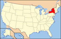
New York is a state in the Northeastern region of the United States. It is the nation's third most populous state. New York is bordered by New Jersey and Pennsylvania to the south, and by Connecticut, Massachusetts and Vermont to the east...
State varies widely.
While the state is best known for New York City
New York City
New York is the most populous city in the United States and the center of the New York Metropolitan Area, one of the most populous metropolitan areas in the world. New York exerts a significant impact upon global commerce, finance, media, art, fashion, research, technology, education, and...
's urban atmosphere, especially Manhattan
Manhattan
Manhattan is the oldest and the most densely populated of the five boroughs of New York City. Located primarily on the island of Manhattan at the mouth of the Hudson River, the boundaries of the borough are identical to those of New York County, an original county of the state of New York...
's skyscrapers, most of the state is dominated by farms, forests, rivers, mountains, and lakes. New York's Adirondack Park is larger than any U.S. National Park
National Park Service
The National Park Service is the U.S. federal agency that manages all national parks, many national monuments, and other conservation and historical properties with various title designations...
in the contiguous United States
Contiguous United States
The contiguous United States are the 48 U.S. states on the continent of North America that are south of Canada and north of Mexico, plus the District of Columbia....
. Niagara Falls
Niagara Falls
The Niagara Falls, located on the Niagara River draining Lake Erie into Lake Ontario, is the collective name for the Horseshoe Falls and the adjacent American Falls along with the comparatively small Bridal Veil Falls, which combined form the highest flow rate of any waterfalls in the world and has...
, on the Niagara River
Niagara River
The Niagara River flows north from Lake Erie to Lake Ontario. It forms part of the border between the Province of Ontario in Canada and New York State in the United States. There are differing theories as to the origin of the name of the river...
as it flows from Lake Erie
Lake Erie
Lake Erie is the fourth largest lake of the five Great Lakes in North America, and the tenth largest globally. It is the southernmost, shallowest, and smallest by volume of the Great Lakes and therefore also has the shortest average water residence time. It is bounded on the north by the...
to Lake Ontario
Lake Ontario
Lake Ontario is one of the five Great Lakes of North America. It is bounded on the north and southwest by the Canadian province of Ontario, and on the south by the American state of New York. Ontario, Canada's most populous province, was named for the lake. In the Wyandot language, ontarío means...
, is a popular attraction. The Hudson River
Hudson River
The Hudson is a river that flows from north to south through eastern New York. The highest official source is at Lake Tear of the Clouds, on the slopes of Mount Marcy in the Adirondack Mountains. The river itself officially begins in Henderson Lake in Newcomb, New York...
begins with Lake Tear of the Clouds
Lake Tear of the Clouds
Lake Tear of the Clouds is a small tarn located in the town of Keene, in Essex County, New York, on the southwest slope of Mount Marcy; it is both the highest lake in the state and the highest source of the Hudson River via Feldspar Brook and the Opalescent River...
and flows south through the eastern part of the state without draining lakes George
Lake George (New York)
Lake George, nicknamed the Queen of American Lakes, is a long, narrow oligotrophic lake draining northwards into Lake Champlain and the St. Lawrence River Drainage basin located at the southeast base of the Adirondack Mountains in northern New York, U.S.A.. It lies within the upper region of the...
or Champlain
Lake Champlain
Lake Champlain is a natural, freshwater lake in North America, located mainly within the borders of the United States but partially situated across the Canada—United States border in the Canadian province of Quebec.The New York portion of the Champlain Valley includes the eastern portions of...
. Lake George empties at its north end into Lake Champlain, whose northern end extends into Canada
Canada
Canada is a North American country consisting of ten provinces and three territories. Located in the northern part of the continent, it extends from the Atlantic Ocean in the east to the Pacific Ocean in the west, and northward into the Arctic Ocean...
, where it drains into the Richelieu River
Richelieu River
The Richelieu River is a river in Quebec, Canada. It flows from the north end of Lake Champlain about north, ending at the confluence with the St. Lawrence River at Sorel-Tracy, Quebec downstream and northeast of Montreal...
and then the St. Lawrence
Saint Lawrence River
The Saint Lawrence is a large river flowing approximately from southwest to northeast in the middle latitudes of North America, connecting the Great Lakes with the Atlantic Ocean. It is the primary drainage conveyor of the Great Lakes Basin...
. Four of New York City's five boroughs are on the three islands at the mouth of the Hudson River: Manhattan Island, Staten Island
Staten Island
Staten Island is a borough of New York City, New York, United States, located in the southwest part of the city. Staten Island is separated from New Jersey by the Arthur Kill and the Kill Van Kull, and from the rest of New York by New York Bay...
, and Brooklyn
Brooklyn
Brooklyn is the most populous of New York City's five boroughs, with nearly 2.6 million residents, and the second-largest in area. Since 1896, Brooklyn has had the same boundaries as Kings County, which is now the most populous county in New York State and the second-most densely populated...
and Queens
Queens
Queens is the easternmost of the five boroughs of New York City. The largest borough in area and the second-largest in population, it is coextensive with Queens County, an administrative division of New York state, in the United States....
on Long Island
Long Island
Long Island is an island located in the southeast part of the U.S. state of New York, just east of Manhattan. Stretching northeast into the Atlantic Ocean, Long Island contains four counties, two of which are boroughs of New York City , and two of which are mainly suburban...
.
"Upstate"
Upstate New York
Upstate New York is the region of the U.S. state of New York that is located north of the core of the New York metropolitan area.-Definition:There is no clear or official boundary between Upstate New York and Downstate New York...
is a common term for New York counties north of suburban Westchester
Westchester County, New York
Westchester County is a county located in the U.S. state of New York. Westchester covers an area of and has a population of 949,113 according to the 2010 Census, residing in 45 municipalities...
, Rockland
Rockland County, New York
Rockland County is a suburban county 15 miles to the northwest of Manhattan and part of the New York City Metropolitan Area, in the U.S. state of New York. It is the southernmost county in New York west of the Hudson River, and the smallest county in New York outside of New York City. The...
and Dutchess
Dutchess County, New York
Dutchess County is a county located in the U.S. state of New York, in the state's Mid-Hudson Region of the Hudson Valley. The 2010 census lists the population as 297,488...
counties. Upstate New York typically includes Lake George
Lake George (New York)
Lake George, nicknamed the Queen of American Lakes, is a long, narrow oligotrophic lake draining northwards into Lake Champlain and the St. Lawrence River Drainage basin located at the southeast base of the Adirondack Mountains in northern New York, U.S.A.. It lies within the upper region of the...
and Oneida Lake
Oneida Lake
Oneida Lake is the largest lake entirely within New York State . The lake is located northeast of Syracuse and near the Great Lakes. It serves as one of the links in the Erie Canal. It empties into the Oneida River which flows into the Oswego River which in turn flows into Lake Ontario...
in the northeast; and rivers such as the Delaware
Delaware River
The Delaware River is a major river on the Atlantic coast of the United States.A Dutch expedition led by Henry Hudson in 1609 first mapped the river. The river was christened the South River in the New Netherland colony that followed, in contrast to the North River, as the Hudson River was then...
, Genesee
Genesee River
The Genesee River is a North American river flowing northward through the Twin Tiers of Pennsylvania and New York. The river provided the original power for the Rochester area's 19th century mills and still provides hydroelectric power for downtown Rochester....
, Mohawk
Mohawk River
The Mohawk River is a river in the U.S. state of New York. It is the largest tributary of the Hudson River. The Mohawk flows into the Hudson in the Capital District, a few miles north of the city of Albany. The river is named for the Mohawk Nation of the Iroquois Confederacy...
, and Susquehanna
Susquehanna River
The Susquehanna River is a river located in the northeastern United States. At long, it is the longest river on the American east coast that drains into the Atlantic Ocean, and with its watershed it is the 16th largest river in the United States, and the longest river in the continental United...
. The highest elevation in New York is Mount Marcy
Mount Marcy
Mount Marcy is the highest point in New York State, with an elevation of . It is a popular destination for hikers due to its stature and great views, and the peak can get very crowded in the summer months...
in the Adirondacks
Adirondack Mountains
The Adirondack Mountains are a mountain range located in the northeastern part of New York, that runs through Clinton, Essex, Franklin, Fulton, Hamilton, Herkimer, Lewis, Saint Lawrence, Saratoga, Warren, and Washington counties....
.
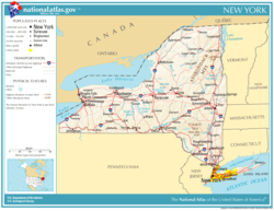
Location and size
United States Census Bureau
The United States Census Bureau is the government agency that is responsible for the United States Census. It also gathers other national demographic and economic data...
division. New York covers an area of 54,556 square miles (141,299 km²) and ranks as the 27th largest state by size. The state borders six U.S. state
U.S. state
A U.S. state is any one of the 50 federated states of the United States of America that share sovereignty with the federal government. Because of this shared sovereignty, an American is a citizen both of the federal entity and of his or her state of domicile. Four states use the official title of...
s: Pennsylvania
Pennsylvania
The Commonwealth of Pennsylvania is a U.S. state that is located in the Northeastern and Mid-Atlantic regions of the United States. The state borders Delaware and Maryland to the south, West Virginia to the southwest, Ohio to the west, New York and Ontario, Canada, to the north, and New Jersey to...
and New Jersey
New Jersey
New Jersey is a state in the Northeastern and Middle Atlantic regions of the United States. , its population was 8,791,894. It is bordered on the north and east by the state of New York, on the southeast and south by the Atlantic Ocean, on the west by Pennsylvania and on the southwest by Delaware...
to the south, and Connecticut
Connecticut
Connecticut is a state in the New England region of the northeastern United States. It is bordered by Rhode Island to the east, Massachusetts to the north, and the state of New York to the west and the south .Connecticut is named for the Connecticut River, the major U.S. river that approximately...
, Rhode Island
Rhode Island
The state of Rhode Island and Providence Plantations, more commonly referred to as Rhode Island , is a state in the New England region of the United States. It is the smallest U.S. state by area...
(across Long Island Sound
Long Island Sound
Long Island Sound is an estuary of the Atlantic Ocean, located in the United States between Connecticut to the north and Long Island, New York to the south. The mouth of the Connecticut River at Old Saybrook, Connecticut, empties into the sound. On its western end the sound is bounded by the Bronx...
), Massachusetts
Massachusetts
The Commonwealth of Massachusetts is a state in the New England region of the northeastern United States of America. It is bordered by Rhode Island and Connecticut to the south, New York to the west, and Vermont and New Hampshire to the north; at its east lies the Atlantic Ocean. As of the 2010...
, and Vermont
Vermont
Vermont is a state in the New England region of the northeastern United States of America. The state ranks 43rd in land area, , and 45th in total area. Its population according to the 2010 census, 630,337, is the second smallest in the country, larger only than Wyoming. It is the only New England...
to the east. New York also borders the Canadian
Canada
Canada is a North American country consisting of ten provinces and three territories. Located in the northern part of the continent, it extends from the Atlantic Ocean in the east to the Pacific Ocean in the west, and northward into the Arctic Ocean...
provinces
Provinces and territories of Canada
The provinces and territories of Canada combine to make up the world's second-largest country by area. There are ten provinces and three territories...
of Ontario
Ontario
Ontario is a province of Canada, located in east-central Canada. It is Canada's most populous province and second largest in total area. It is home to the nation's most populous city, Toronto, and the nation's capital, Ottawa....
and Quebec
Quebec
Quebec or is a province in east-central Canada. It is the only Canadian province with a predominantly French-speaking population and the only one whose sole official language is French at the provincial level....
to the north. Additionally, New York touches the Atlantic Ocean
Atlantic Ocean
The Atlantic Ocean is the second-largest of the world's oceanic divisions. With a total area of about , it covers approximately 20% of the Earth's surface and about 26% of its water surface area...
to the southeast, and two of the Great Lakes
Great Lakes
The Great Lakes are a collection of freshwater lakes located in northeastern North America, on the Canada – United States border. Consisting of Lakes Superior, Michigan, Huron, Erie, and Ontario, they form the largest group of freshwater lakes on Earth by total surface, coming in second by volume...
: Lake Erie
Lake Erie
Lake Erie is the fourth largest lake of the five Great Lakes in North America, and the tenth largest globally. It is the southernmost, shallowest, and smallest by volume of the Great Lakes and therefore also has the shortest average water residence time. It is bounded on the north by the...
to the west and Lake Ontario
Lake Ontario
Lake Ontario is one of the five Great Lakes of North America. It is bounded on the north and southwest by the Canadian province of Ontario, and on the south by the American state of New York. Ontario, Canada's most populous province, was named for the lake. In the Wyandot language, ontarío means...
to the northwest.
Topography
New York lies upon the portion of the Appalachian MountainsAppalachian Mountains
The Appalachian Mountains #Whether the stressed vowel is or ,#Whether the "ch" is pronounced as a fricative or an affricate , and#Whether the final vowel is the monophthong or the diphthong .), often called the Appalachians, are a system of mountains in eastern North America. The Appalachians...
system where the mountains generally assume the character of hills and finally sink to a level of the lowlands that surround the great depression filled by Lake Ontario
Lake Ontario
Lake Ontario is one of the five Great Lakes of North America. It is bounded on the north and southwest by the Canadian province of Ontario, and on the south by the American state of New York. Ontario, Canada's most populous province, was named for the lake. In the Wyandot language, ontarío means...
and the St. Lawrence River. Three distinct mountain masses can be identified in the state. The most easterly of these ranges—a continuation of the Blue Ridge Mountains
Blue Ridge Mountains
The Blue Ridge Mountains are a physiographic province of the larger Appalachian Mountains range. This province consists of northern and southern physiographic regions, which divide near the Roanoke River gap. The mountain range is located in the eastern United States, starting at its southern-most...
of Virginia
Virginia
The Commonwealth of Virginia , is a U.S. state on the Atlantic Coast of the Southern United States. Virginia is nicknamed the "Old Dominion" and sometimes the "Mother of Presidents" after the eight U.S. presidents born there...
—enters the state from New Jersey
New Jersey
New Jersey is a state in the Northeastern and Middle Atlantic regions of the United States. , its population was 8,791,894. It is bordered on the north and east by the state of New York, on the southeast and south by the Atlantic Ocean, on the west by Pennsylvania and on the southwest by Delaware...
and extends northeast through Rockland
Rockland County, New York
Rockland County is a suburban county 15 miles to the northwest of Manhattan and part of the New York City Metropolitan Area, in the U.S. state of New York. It is the southernmost county in New York west of the Hudson River, and the smallest county in New York outside of New York City. The...
and Orange
Orange County, New York
Orange County is a county located in the U.S. state of New York. It is part of the Poughkeepsie–Newburgh–Middletown, NY Metropolitan Statistical Area and is located at the northern reaches of the New York metropolitan area. The county sits in the state's scenic Mid-Hudson Region of the Hudson Valley...
counties to the Hudson River
Hudson River
The Hudson is a river that flows from north to south through eastern New York. The highest official source is at Lake Tear of the Clouds, on the slopes of Mount Marcy in the Adirondack Mountains. The river itself officially begins in Henderson Lake in Newcomb, New York...
, continuing on the east side of that river as the highlands of Putnam
Putnam County, New York
Putnam County is a county located in the U.S. state of New York, in the lower Hudson River Valley. Putnam county formed in 1812, when it detached from Dutchess County. , the population was 99,710. It is part of the New York Metropolitan Area. The county seat is the hamlet of Carmel...
and Dutchess
Dutchess County, New York
Dutchess County is a county located in the U.S. state of New York, in the state's Mid-Hudson Region of the Hudson Valley. The 2010 census lists the population as 297,488...
counties. A northerly extension of the same range passes into the Green Mountains
Green Mountains
The Green Mountains are a mountain range in the U.S. state of Vermont. The range extends approximately .-Peaks:The most notable mountains in the range include:*Mount Mansfield, , the highest point in Vermont*Killington Peak, *Mount Ellen,...
of western Massachusetts
Massachusetts
The Commonwealth of Massachusetts is a state in the New England region of the northeastern United States of America. It is bordered by Rhode Island and Connecticut to the south, New York to the west, and Vermont and New Hampshire to the north; at its east lies the Atlantic Ocean. As of the 2010...
and Vermont
Vermont
Vermont is a state in the New England region of the northeastern United States of America. The state ranks 43rd in land area, , and 45th in total area. Its population according to the 2010 census, 630,337, is the second smallest in the country, larger only than Wyoming. It is the only New England...
. This range is known in New York as the Hudson Highlands
Hudson Highlands
The Hudson Highlands are mountains on both sides of the Hudson River in the U.S. state of New York, between Newburgh Bay and Haverstraw Bay, which form the northern region of the New York - New Jersey Highlands....
. The highest peaks are 1000 to 1700 ft (304.8 to 518.2 m) above sea level. The rocks which compose these mountains are principally primitive or igneous
Igneous rock
Igneous rock is one of the three main rock types, the others being sedimentary and metamorphic rock. Igneous rock is formed through the cooling and solidification of magma or lava...
, and the mountains themselves are rough, rocky, and precipitous, and unfit for cultivation.
The second series of mountains enters the state from Pennsylvania
Pennsylvania
The Commonwealth of Pennsylvania is a U.S. state that is located in the Northeastern and Mid-Atlantic regions of the United States. The state borders Delaware and Maryland to the south, West Virginia to the southwest, Ohio to the west, New York and Ontario, Canada, to the north, and New Jersey to...
and extends northeast through Sullivan
Sullivan County, New York
Sullivan County is a county located in the U.S. state of New York. As of the 2010 census, the population was 77,547. The county seat is Monticello. The name is in honor of Major General John Sullivan, who was a hero in the American Revolutionary War...
, Ulster
Ulster County, New York
Ulster County is a county located in the state of New York, USA. It sits in the state's Mid-Hudson Region of the Hudson Valley. As of the 2010 census, the population was 182,493. Recent population estimates completed by the United States Census Bureau for the 12-month period ending July 1 are at...
, and Greene counties, terminating and culminating in the Catskill Mountains
Catskill Mountains
The Catskill Mountains, an area in New York State northwest of New York City and southwest of Albany, are a mature dissected plateau, an uplifted region that was subsequently eroded into sharp relief. They are an eastward continuation, and the highest representation, of the Allegheny Plateau...
west of the Hudson. The highest peaks are 3000 to 3800 ft (914.4 to 1,158.2 m) above sea level. The Shawangunk Mountains, a high and continuous ridge extending between Sullivan and Orange counties and into the southern part of Ulster County, is the extreme eastern range of this series. The Helderberg
Helderberg Escarpment
The Helderberg Escarpment is an escarpment in eastern New York, roughly west of the city of Albany....
and Hellibark Mountains are spurs extending north from the main range into Albany
Albany County, New York
Albany County is a county located in the U.S. state of New York, and is part of the Albany-Schenectady-Troy Metropolitan Statistical Area. The name is from the title of the Duke of York and Albany, who became James II of England . As of the 2010 census, the population was 304,204...
and Schoharie
Schoharie County, New York
As of the census of 2000, there were 31,582 people, 11,991 households and 8,177 families residing in the county. The population density was 51 people per square mile . There were 15,915 housing units at an average density of 26 per square mile...
counties. This whole mountain system is principally composed of rocks of the New York system above the Medina sandstone. The summits are generally crowned with red sandstone
Sandstone
Sandstone is a sedimentary rock composed mainly of sand-sized minerals or rock grains.Most sandstone is composed of quartz and/or feldspar because these are the most common minerals in the Earth's crust. Like sand, sandstone may be any colour, but the most common colours are tan, brown, yellow,...
and with the conglomerate
Conglomerate (geology)
A conglomerate is a rock consisting of individual clasts within a finer-grained matrix that have become cemented together. Conglomerates are sedimentary rocks consisting of rounded fragments and are thus differentiated from breccias, which consist of angular clasts...
of the coal measures. The declivities are steep and rocky, and a large share of the surface is too rough for cultivation.

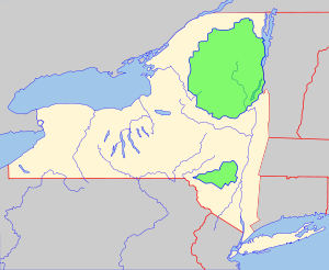
Adirondack Mountains
The Adirondack Mountains are a mountain range located in the northeastern part of New York, that runs through Clinton, Essex, Franklin, Fulton, Hamilton, Herkimer, Lewis, Saint Lawrence, Saratoga, Warren, and Washington counties....
. The region is bounded to the south by the Mohawk River
Mohawk River
The Mohawk River is a river in the U.S. state of New York. It is the largest tributary of the Hudson River. The Mohawk flows into the Hudson in the Capital District, a few miles north of the city of Albany. The river is named for the Mohawk Nation of the Iroquois Confederacy...
, south of which the highlands become part of the Allegheny Plateau
Allegheny Plateau
The Allegheny Plateau is a large dissected plateau area in western and central New York, northern and western Pennsylvania, northern and western West Virginia, and eastern Ohio...
, in the form of broad, irregular hills, broken by the deep ravines of streams. The valley of the Mohawk separates the Allegheny Plateau to the south from the highlands leading to the Adirondacks to the north, reaching its narrowest point in the neighborhood of Little Falls
Little Falls (town), New York
Little Falls is a town in Herkimer County, New York, United States. The population was 1,544 at the 2000 census. The town is named after a waterfall located nearby.The Town of Little Falls has on its eastern end a small city called Little Falls...
, the Noses, and other places. North of the Mohawk the highlands extend northeast in several distinct ranges, all terminating upon Lake Champlain
Lake Champlain
Lake Champlain is a natural, freshwater lake in North America, located mainly within the borders of the United States but partially situated across the Canada—United States border in the Canadian province of Quebec.The New York portion of the Champlain Valley includes the eastern portions of...
. The culminating point of the whole system, and the highest mountain in the state, is Mount Marcy
Mount Marcy
Mount Marcy is the highest point in New York State, with an elevation of . It is a popular destination for hikers due to its stature and great views, and the peak can get very crowded in the summer months...
, standing 5467 feet (1,666.3 m) above sea level. The rocks of all this region are principally of igneous origin, and the mountains are usually wild, rugged, and rocky. A large share of the surface is entirely unfit for cultivation, but the region is rich in minerals, and especially in an excellent variety of iron ore.
In western New York, a series of hills forming spurs of the Allegheny Mountains
Allegheny Mountains
The Allegheny Mountain Range , also spelled Alleghany, Allegany and, informally, the Alleghenies, is part of the vast Appalachian Mountain Range of the eastern United States and Canada...
enter the state from Pennsylvania and occupy the entire southern half of the west part of the state. An irregular line extending through the southerly counties forms the watershed
Drainage basin
A drainage basin is an extent or an area of land where surface water from rain and melting snow or ice converges to a single point, usually the exit of the basin, where the waters join another waterbody, such as a river, lake, reservoir, estuary, wetland, sea, or ocean...
that separates the northern and southern drainage; and from it the surface gradually declines northward until it finally terminates in the level of Lake Ontario
Lake Ontario
Lake Ontario is one of the five Great Lakes of North America. It is bounded on the north and southwest by the Canadian province of Ontario, and on the south by the American state of New York. Ontario, Canada's most populous province, was named for the lake. In the Wyandot language, ontarío means...
. The portion of the state lying south of this watershed and occupying the greater part of the two southerly tiers of counties is entirely occupied by these hills. Along the Pennsylvania line they are usually abrupt and are separated by narrow ravines, but toward the north their summits become broader and less broken. A considerable portion of the highland region is too steep for profitable cultivation and is best adapted to grazing. The highest summits in Allegany
Allegany County, New York
Allegany County is a county located in the U.S. state of New York. As of the 2010 census, the population was 48,946. Its name derives from a Delaware Indian word, applied by settlers of Western New York State to a trail that followed the Allegheny River. Its county seat is...
and Cattaraugus
Cattaraugus County, New York
Cattaraugus County is a county located in the U.S. state of New York. As of the 2010 census, the population was 80,317. The county seat is Little Valley.-History:...
counties are 2000 to 2500 ft (609.6 to 762 m) above sea level.
From the summits of the watershed, the highlands usually descend toward Lake Ontario
Lake Ontario
Lake Ontario is one of the five Great Lakes of North America. It is bounded on the north and southwest by the Canadian province of Ontario, and on the south by the American state of New York. Ontario, Canada's most populous province, was named for the lake. In the Wyandot language, ontarío means...
in a series of terraces, the edges of which are the outcrops of the different rocks which underlie the surface. These terraces are usually smooth, and, although inclined toward the north, the inclination is generally so slight that they appear to be level. Between the hills of the south and the level land of the north is a beautiful rolling region, the ridges gradually declining toward the north. In that part of the state, south of the most eastern mountain range, the surface is generally level or broken by low hills. In Manhattan
Manhattan
Manhattan is the oldest and the most densely populated of the five boroughs of New York City. Located primarily on the island of Manhattan at the mouth of the Hudson River, the boundaries of the borough are identical to those of New York County, an original county of the state of New York...
and Westchester County
Westchester County, New York
Westchester County is a county located in the U.S. state of New York. Westchester covers an area of and has a population of 949,113 according to the 2010 Census, residing in 45 municipalities...
, these hills are principally composed of primitive rocks. The surface of Long Island
Long Island
Long Island is an island located in the southeast part of the U.S. state of New York, just east of Manhattan. Stretching northeast into the Atlantic Ocean, Long Island contains four counties, two of which are boroughs of New York City , and two of which are mainly suburban...
is generally level or gently undulating. A ridge 150 to 200 ft (45.7 to 61 m) high, composed of sand, gravel, and clay, extends east and west across the island north of its center.
Rivers and lakes

Great Lakes
The Great Lakes are a collection of freshwater lakes located in northeastern North America, on the Canada – United States border. Consisting of Lakes Superior, Michigan, Huron, Erie, and Ontario, they form the largest group of freshwater lakes on Earth by total surface, coming in second by volume...
and the St. Lawrence River, and the second being those which flow in a general southerly direction. The watershed divide that separates these two systems extends in an irregular line eastward from Lake Erie
Lake Erie
Lake Erie is the fourth largest lake of the five Great Lakes in North America, and the tenth largest globally. It is the southernmost, shallowest, and smallest by volume of the Great Lakes and therefore also has the shortest average water residence time. It is bounded on the north by the...
through the southern tier of counties to near the northeast corner of Chemung County
Chemung County, New York
Chemung County is a county located in the U.S. state of New York. It is part of the 'Elmira, New York Metropolitan Statistical Area' which encompasses all of Chemung County. As of the 2010 census, the population was 88,830. Its name is derived from the name of a Delaware Indian village . Its...
. It then turns northeast to the Adirondack Mountains
Adirondack Mountains
The Adirondack Mountains are a mountain range located in the northeastern part of New York, that runs through Clinton, Essex, Franklin, Fulton, Hamilton, Herkimer, Lewis, Saint Lawrence, Saratoga, Warren, and Washington counties....
in Essex County
Essex County, New York
Essex County is a county located in the U.S. state of New York. As of the 2010 census, the population was 39,370. Its name is from the English county of Essex. Its county seat is Elizabethtown...
, then southeast to the east extremity of Lake George
Lake George (New York)
Lake George, nicknamed the Queen of American Lakes, is a long, narrow oligotrophic lake draining northwards into Lake Champlain and the St. Lawrence River Drainage basin located at the southeast base of the Adirondack Mountains in northern New York, U.S.A.. It lies within the upper region of the...
, and then nearly due east to the east border of the state.
The northerly division has five general subdivisions. The most westerly of these comprises all the streams flowing into Lake Erie and the Niagara River
Niagara River
The Niagara River flows north from Lake Erie to Lake Ontario. It forms part of the border between the Province of Ontario in Canada and New York State in the United States. There are differing theories as to the origin of the name of the river...
and those flowing into Lake Ontario west of the Genesee River
Genesee River
The Genesee River is a North American river flowing northward through the Twin Tiers of Pennsylvania and New York. The river provided the original power for the Rochester area's 19th century mills and still provides hydroelectric power for downtown Rochester....
. In Chautauqua County
Chautauqua County, New York
-Major highways:* Interstate 86/New York State Route 17 * Interstate 90 * U.S. Route 20* U.S. Route 62* New York State Route 5* New York State Route 39* New York State Route 60* New York State Route 394...
, the streams are short and rapid, as the watershed approaches within a few miles of Lake Erie. Cattaraugus
Cattaraugus Creek
Cattaraugus Creek is a stream, approximately 68 miles long, in western New York in the United States. The creek drains a wooded rural portion of western New York southwest of Buffalo into Lake Erie. In its lower course it flows primarily through the Cattaraugus Reservation of the Seneca tribe...
, Buffalo
Buffalo River (New York)
The Buffalo River is a river that empties into the eastern end of Lake Erie, one of the Great Lakes, by the City of Buffalo in the United States of America. This stream is called the Buffalo River only in the vicinity of the city and is known as Buffalo Creek as it flows through other parts of...
, Tonawanda
Tonawanda Creek
Tonawanda Creek is a small river in Western New York, in the United States. William Bright says the best that can be said of the name is that it is "probably from an Iroquoian source, but of unclear derivation".-Description:...
, and Oak Orchard creeks are the most important streams in this division. Buffalo Creek is chiefly noted for forming Buffalo
Buffalo, New York
Buffalo is the second most populous city in the state of New York, after New York City. Located in Western New York on the eastern shores of Lake Erie and at the head of the Niagara River across from Fort Erie, Ontario, Buffalo is the seat of Erie County and the principal city of the...
Harbor at its mouth; and the Tonawanda for 12 miles (19.3 km) from its mouth was once used for canal navigation. Oak Orchard and other creeks flowing into Lake Ontario descend from the interior in a series of rapids, affording a large amount of waterpower.

Genesee River
The Genesee River is a North American river flowing northward through the Twin Tiers of Pennsylvania and New York. The river provided the original power for the Rochester area's 19th century mills and still provides hydroelectric power for downtown Rochester....
and its tributaries. The Genesee rises in the northern part of Pennsylvania and flows in a generally northerly direction to Lake Ontario. Its upper course is through a narrow valley bordered by steep, rocky hills. Upon the line of Wyoming
Wyoming County, New York
Wyoming County is a county located in the U.S. state of New York. At the 2010 census, the population was 42,155. The county seat is Warsaw. The name is from a modified Delaware Indian word meaning "broad bottom lands"...
and Livingston
Livingston County, New York
As of the census of 2000, there were 64,328 people, 22,150 households, and 15,349 families residing in the county. The population density was 102 people per square mile . There were 24,023 housing units at an average density of 38 per square mile...
counties, it breaks through a mountain barrier in a deep gorge
Letchworth State Park
Letchworth State Park is a New York state park located 35 miles southwest of Rochester and 60 miles southeast of Buffalo in Livingston and Wyoming counties. The park is roughly 17 miles long, covering of land along the Genesee River...
and forms the Portage Falls. Below this point the course of the river is through a valley 1 to 2 mi (1.6 to 3.2 km) wide and bordered by banks 50 to 150 ft (15.2 to 45.7 m) high. At Rochester
Rochester, New York
Rochester is a city in Monroe County, New York, south of Lake Ontario in the United States. Known as The World's Image Centre, it was also once known as The Flour City, and more recently as The Flower City...
it flows over the precipitous edges of the Niagara limestone, forming the Upper Genesee Falls; and 3 miles (4.8 km) below it flows over the edge of the Medina sandstone, forming the Lower Genesee Falls. The principal tributaries of this stream are Canaseraga, Honeoye
Honeoye Creek
Honeoye Creek is a tributary of the Genesee River in western New York in the United States.Honeoye Creek emerges from the north end of Honeoye Lake, one of the Finger Lakes, in Richmond, Ontario County...
, and Conesus
Conesus Creek
-Geography:The creek forms from the outflow of Conesus Lake to later join the Genessee River in the Town of Avon. The creek drops over 200 feet in elevation over its short course.-Navigability:...
creeks from the south, and Oatka
Oatka Creek
Oatka Creek is the third longest tributary of the Genesee River, located entirely in the Western New York region of the U.S. state of New York. From southern Wyoming County, it flows to the Genesee near Scottsville, draining an area of that includes all or part of 23 towns and villages in...
and Black
Black Creek, New York
Black Creek is a hamlet in the town of New Hudson, in Allegany County, New York, United States. The name is derived from a stream that flows nearby. The community lies between Cuba and Belfast on Route 305....
creeks from the west. Honeoye
Honeoye Lake
Honeoye Lake is one of the Finger Lakes of New York State in the USA. The lake is in Ontario County. Honeoye is an Iroquois word translated as "a lying finger," or "where the finger lies." Most of the lake is within the town of Richmond but a smaller southwestern part is in the town of Canadice...
, Canadice
Canadice Lake
Canadice Lake is one of the minor Finger Lakes of western New York in the USA.Canadice Lake has a shoreline 6.5 miles long and a maximum depth of 95 feet . Because the lake is a water source of Rochester, New York, no houses are permitted on its shore and boats are limited to 16 feet in length...
, Hemlock
Hemlock Lake
Hemlock Lake is one of the minor Finger Lakes. It is mostly located in Livingston County, New York, south of Rochester, with a portion overlapping into Ontario County....
, and Conesus
Conesus Lake
Conesus Lake is one of the minor Finger Lakes in western New York. It is western-most of eleven total Finger Lakes. The lake's outlet is in Lakeville, New York a hamlet in the Town of Livonia, New York in Livingston County, south of Rochester, New York. The lake's inlet is in the Town of Conesus,...
lakes—four of the Finger Lakes
Finger Lakes
The Finger Lakes are a pattern of lakes in the west-central section of Upstate New York in the United States. They are a popular tourist destination. The lakes are long and thin , each oriented roughly on a north-south axis. The two longest, Cayuga Lake and Seneca Lake, are among the deepest in...
—lie within the Genesee Basin.
The third subdivision includes the Oswego River
Oswego River (New York)
The Oswego River is a river in upstate New York in the United States. This river is the second-largest river flowing into Lake Ontario. James Fenimore Cooper’s novel The Pathfinder, or The Inland Sea is set in the Oswego River valley...
and its tributaries, and the small streams flowing into Lake Ontario between the Genesee and Oswego rivers. The basin of the Oswego includes most of the inland lakes which form a peculiar feature of the landscape in the interior of the state. The principal of these lakes are Cayuga
Cayuga Lake
Cayuga Lake is the longest of central New York's glacial Finger Lakes, and is the second largest in surface area and second largest in volume. It is just under 40 miles long. Its average width is 1.7 miles , and it is at its widest point near Aurora...
, Seneca, Canandaigua
Canandaigua Lake
Canandaigua Lake is the fourth largest of the Finger Lakes, in the U.S. state of New York. The city of Canandaigua is located at the northern shore of the lake and the village of Naples is just a few miles south of the southern end...
, Skaneateles
Skaneateles Lake
Skaneateles Lake is one of the Finger Lakes in central New York in the United States. The name Skaneateles means long lake in one of the local Iroquoian languages. The lake is sometimes referred to as "The Roof Garden of the Lakes" because its altitude is higher than the other Finger Lakes. It...
, Crooked, and Owasco
Owasco Lake
Owasco Lake is the sixth largest and third easternmost of the Finger Lakes of New York in the United States of America . The name Owasco can be roughly translated from a Mohawk and Iroquois term meaning "crossing"....
lakes, all occupying long, narrow valleys, and extending from the level land in the center far into the highland region of the south (many of those lakes just mentioned are also part of the Finger Lakes). The valleys which they occupy appear like immense ravines formed by some tremendous force, which has torn the solid rocks from their original beds, from the general level of the surrounding summits, down to the present bottoms of the lakes. Oneida
Oneida Lake
Oneida Lake is the largest lake entirely within New York State . The lake is located northeast of Syracuse and near the Great Lakes. It serves as one of the links in the Erie Canal. It empties into the Oneida River which flows into the Oswego River which in turn flows into Lake Ontario...
and Onondaga
Onondaga Lake
Onondaga Lake is a lake in Central New York located northwest of Syracuse, New York. The southeastern end of the lake and the southwestern shore abut industrial areas and expressways; the northeastern shore and northwestern end border a series of parks and museums. Although it is near the Finger...
lakes occupy level land in the northeast part of the Oswego Basin. Mud Creek, the most westerly branch of the Oswego River, takes its rise in Ontario County
Ontario County, New York
As of the census of 2000, there were 100,224 people, 38,370 households, and 26,360 families residing in the county. The population density was 156 people per square mile . There were 42,647 housing units at an average density of 66 per square mile...
, flows northeast into Wayne County
Wayne County, New York
Wayne County is a county located in the US state of New York. It is part of the Rochester, New York Metropolitan Statistical Area and lies on the south shore of Lake Ontario, forming part of the northern border of the United States with Canada. The name honors General Anthony Wayne, an American...
, where it unites with Canandaigua Outlet and takes the name of Clyde River; then it flows east to the west line of Cayuga County
Cayuga County, New York
Cayuga County is a county located in the U.S. state of New York. It was named for one of the tribes of Indians in the Iroquois Confederation. Its county seat is Auburn.- History :...
, where it empties into the Seneca River
Seneca River (New York)
The Seneca River in central New York flows from west to east, from Seneca Lake, through the Montezuma Marsh at the north end of Cayuga Lake to the Seneca's confluence with the Oneida and Oswego rivers at the Three Rivers area north of Syracuse. Much of the river has been channelized to form part...
. This latter stream, made up of the outlets of Seneca and Cayuga Lakes, from this point flows in a northeasterly course, and receives successively the outlets of Owasco, Skaneateles, Onondaga, and Oneida lakes. From the mouth of the last-named stream it takes the name Oswego River, and its course is nearly due north to Lake Ontario.
The fourth subdivision includes the streams flowing into Lake Ontario and the St. Lawrence River east of the mouth of the Oswego. The principal of these are the Salmon
Salmon River (New York)
The Salmon River arises in north central New York State on the Tug Hill Plateau to the east of Lake Ontario. It flows westward off the plateau and there is a hydroelectric dam near Little America to create the Salmon River Reservoir. Both the Salmon River and Salmon River Reservoir are heavily...
, Black
Black River (New York)
The Black River is a blackwater river that empties into the eastern end of Lake Ontario on the shore of Jefferson County, New York in the United States of America...
, Oswegatchie
Oswegatchie River
The Oswegatchie River is a river in northern New York that flows north from the Adirondack Mountains to the Saint Lawrence River at the city of Ogdensburg. The river mouth was the site of a Jesuit mission, Fort de La Présentation, founded in 1749. Also a fur trading post, the village had 3,000...
, Grasse
Grasse River
The Grasse River or Grass River is a river in northern New York, in the United States...
, and Raquette
Raquette River
The Raquette River, sometimes spelled Racquette, originates at Raquette Lake in the Adirondack Mountains in New York. long, it is the third longest river entirely in the state of New York....
rivers. The water is usually very dark, being colored with iron and the vegetation of swamps.
The fifth subdivision includes all the streams flowing into Lakes George and Champlain. They are mostly mountain torrents, frequently interrupted by cascades. The principal streams are the Chazy
Chazy River
Chazy River is the name of two tributaries of Lake Champlain in Clinton County, New York in the United States.The more northerly river is the Great Chazy River, which empties into Lake Champlain at King Bay in the Town of Champlain....
, Saranac
Saranac River
Saranac River is an river in the U.S. state of New York. In its upper reaches is a region of mostly flat water and lakes. The river has more than three dozen source lakes and ponds north of Upper Saranac Lake; the highest is Mountain Pond on Long Pond Mountain...
, and Ausable rivers, and Wood Creek. Deep strata of Tertiary
Tertiary
The Tertiary is a deprecated term for a geologic period 65 million to 2.6 million years ago. The Tertiary covered the time span between the superseded Secondary period and the Quaternary...
clay extend along the shores of Lake Champlain and Wood Creek. The water of most of the streams in this region is colored by the iron over which it flows.
Allegheny River
The Allegheny River is a principal tributary of the Ohio River; it is located in the Eastern United States. The Allegheny River joins with the Monongahela River to form the Ohio River at the "Point" of Point State Park in Downtown Pittsburgh, Pennsylvania...
, Susquehanna
Susquehanna River
The Susquehanna River is a river located in the northeastern United States. At long, it is the longest river on the American east coast that drains into the Atlantic Ocean, and with its watershed it is the 16th largest river in the United States, and the longest river in the continental United...
, Delaware
Delaware River
The Delaware River is a major river on the Atlantic coast of the United States.A Dutch expedition led by Henry Hudson in 1609 first mapped the river. The river was christened the South River in the New Netherland colony that followed, in contrast to the North River, as the Hudson River was then...
, and Hudson
Hudson River
The Hudson is a river that flows from north to south through eastern New York. The highest official source is at Lake Tear of the Clouds, on the slopes of Mount Marcy in the Adirondack Mountains. The river itself officially begins in Henderson Lake in Newcomb, New York...
. The Allegheny Basin embraces the southerly half of Chautauqua
Chautauqua County, New York
-Major highways:* Interstate 86/New York State Route 17 * Interstate 90 * U.S. Route 20* U.S. Route 62* New York State Route 5* New York State Route 39* New York State Route 60* New York State Route 394...
and Cattaraugus
Cattaraugus County, New York
Cattaraugus County is a county located in the U.S. state of New York. As of the 2010 census, the population was 80,317. The county seat is Little Valley.-History:...
counties and the southwest corner of Allegany County
Allegany County, New York
Allegany County is a county located in the U.S. state of New York. As of the 2010 census, the population was 48,946. Its name derives from a Delaware Indian word, applied by settlers of Western New York State to a trail that followed the Allegheny River. Its county seat is...
. The Allegheny River enters the state from the south in the southeast corner of Cattaraugus County, flows in nearly a semicircle, with its outward curve toward the north, and flows out of the state in the southwest part of the same county. It receives several tributaries from the north and east. These streams mostly flow in deep ravines bordered by steep, rocky hillsides. The watershed between this basin and Lake Erie approaches within a few miles of the lake, and is elevated 800 to 1000 ft (243.8 to 304.8 m) above it.
The Susquehanna Basin occupies about one-third of the south border of the state. The river takes its rise in Otsego Lake, and, flowing southwest to the Pennsylvania line, receives Charlotte River from the south and the Unadilla River
Unadilla River
The Unadilla River in New York State flows from south of Utica to the village of Sidney, where it flows into the Susquehanna River, which eventually empties into the Chesapeake Bay, an arm of the Atlantic Ocean....
from the north. After a course of a few miles in Pennsylvania, it again enters New York and flows in a general westerly direction to near the western border of Tioga County
Tioga County, New York
As of the census of 2010, there were 51,125 people residing in the county, with 22,203 housing units, of these 20,350 occupied, 1,853 vacant. The population density was 98 people per square mile...
, whence it turns south and again enters Pennsylvania. Its principal tributary from the north is the Chenango River
Chenango River
The Chenango River is a tributary of the Susquehanna River in central New York in the United States. It drains a dissected plateau area in upstate New York at the northern end of the Susquehanna watershed....
. The Tioga River
Tioga River (Chemung River)
The Tioga River is a tributary of the Chemung River, approximately long, in northern Pennsylvania and western New York in the United States...
enters New York from Pennsylvania near the eastern border of Steuben County
Steuben County, New York
Steuben County is a county located in the U.S. state of New York. As of the 2010 census, the population was 98,990. Its name is in honor of Baron von Steuben, a German general who fought on the American side in the American Revolutionary War, though it is not pronounced the same...
, flows north, receives the Canisteo River
Canisteo River
The Canisteo River is a tributary of the Tioga River in western New York in the United States. It drains a dissected plateau, a portion of the northern Allegheny Plateau southwest of the Finger Lakes region, in the far northwestern reaches of the watershed of the Susquehanna River.It rises in the...
from the west and the Cohocton River
Cohocton River
The Cohocton River is a tributary of the Chemung River in western New York in the United States. Via the Chemung River, it is part of the Susquehanna River watershed, flowing to Chesapeake Bay...
from the north. From the mouth of the latter, the stream takes the name Chemung River
Chemung River
The Chemung River is a tributary of the Susquehanna River, approximately long, in south central New York and northern Pennsylvania in the United States. It drains a mountainous region of the northern Allegheny Plateau in the Southern Tier of New York...
, and flows in a southeast direction, into the Susquehanna River in Pennsylvania, a few miles south of the state line. The upper course of these streams is generally through deep ravines bordered by steep hillsides, but below they are bordered by wide intervales.
Delaware County, New York
Delaware County is a county located in the U.S. state of New York. As of 2010 the population was 47,980. The county seat is Delhi. It is named after the Delaware River, which was named in honor of Thomas West, 3rd Baron De La Warr, appointed governor of Virginia in 1609.-History:When counties...
and Sullivan
Sullivan County, New York
Sullivan County is a county located in the U.S. state of New York. As of the 2010 census, the population was 77,547. The county seat is Monticello. The name is in honor of Major General John Sullivan, who was a hero in the American Revolutionary War...
counties and portions of several of the adjacent counties. The north or principal branch of the river rises in the northeast part of Delaware County and flows southwest to near the Pennsylvania line; then it turns southwest and forms the boundary of the state to the line of New Jersey. Its principal branches are the Pepacton
Pepacton Reservoir
The Pepacton Reservoir, also known as the Downsville Reservoir or the Downsville Dam, is a reservoir in Delaware County, New York that was formed by impounding over ¼ of the East Branch of the Delaware River...
and Neversink
Neversink River
The Neversink River is a tributary of the Delaware River in southeastern New York in the United States...
rivers. These streams all flow in deep, narrow ravines bordered by steep, rocky hills.

Hudson Valley
The Hudson Valley comprises the valley of the Hudson River and its adjacent communities in New York State, United States, from northern Westchester County northward to the cities of Albany and Troy.-History:...
occupies about two-thirds of the east border of the state, and a large territory extending into the interior. The remote sources of the Hudson are among the highest peaks of the Adirondacks, more than 4000 feet (1,219.2 m) above sea level. Several of the little lakes which form reservoirs of the Upper Hudson are 2500 to 3000 ft (762 to 914.4 m) above sea level. The stream rapidly descends through the narrow defiles into Warren County
Warren County, New York
Warren County is a county in the U.S. state of New York. It is part of the Glens Falls, New York, Metropolitan Statistical Area. As of the 2010 census, the population was 65,707. It is named in honor of General Joseph Warren, an American Revolutionary War hero of the Battle of Bunker Hill...
, where it receives from the east the outlet of Schroon Lake, and the Sacandaga River
Sacandaga River
The Sacandaga River is a river in the northern part of New York in the United States. Its name comes from the Native American Sa-chen-da'-ga, meaning "overflowed lands"....
from the west. Below the mouth of the latter the river turns eastward, and breaks through the barrier of the Luzerne Mountains in a series of rapids and falls. At Fort Edward it again turns south and flows with a rapid current, frequently interrupted by falls, to Troy
Troy, New York
Troy is a city in the US State of New York and the seat of Rensselaer County. Troy is located on the western edge of Rensselaer County and on the eastern bank of the Hudson River. Troy has close ties to the nearby cities of Albany and Schenectady, forming a region popularly called the Capital...
, 160 miles (257.5 km) from the ocean. At this place the river falls into an estuary
Estuary
An estuary is a partly enclosed coastal body of water with one or more rivers or streams flowing into it, and with a free connection to the open sea....
, where its current is affected by the tide; and from this place to its mouth it is a broad, deep, sluggish stream. About 60 miles (96.6 km) from its mouth the Hudson breaks through the rocky barrier of the highlands
Hudson Highlands
The Hudson Highlands are mountains on both sides of the Hudson River in the U.S. state of New York, between Newburgh Bay and Haverstraw Bay, which form the northern region of the New York - New Jersey Highlands....
, forming the most easterly of the Appalachian Mountain ranges; and along its lower course it is bordered on the west by a nearly perpendicular wall of basaltic rock 300 to 500 ft (91.4 to 152.4 m) high, known as The Palisades. Above Troy, the Hudson receives the Hoosic River
Hoosic River
The Hoosic River, also known as the Hoosac, the Hoosick and the Hoosuck , is a tributary of the Hudson River in the northeastern United States. The different spellings are the result of varying transliterations of the river's original Algonquian name...
from the east and the Mohawk River
Mohawk River
The Mohawk River is a river in the U.S. state of New York. It is the largest tributary of the Hudson River. The Mohawk flows into the Hudson in the Capital District, a few miles north of the city of Albany. The river is named for the Mohawk Nation of the Iroquois Confederacy...
from the west. The former stream rises in western Massachusetts and Vermont, and the latter near the center of New York.
At Little Falls and The Noses, the Mohawk breaks through mountain barriers in a deep, rocky ravine; and at Cohoes
Cohoes, New York
Cohoes is an incorporated city located at the northeast corner of Albany County in the US state of New York. It is called the "Spindle City" because of the importance of textile production to its growth. As of the 2010 census, the city population was 16,168...
, about 1 miles (1.6 km) from its mouth, it flows down a perpendicular precipice of 70 feet (21.3 m). Below Troy the tributaries of the Hudson are all comparatively small streams. South of the highlands the river spreads out into a wide expanse known as Haverstraw Bay
Haverstraw Bay
Haverstraw Bay, located in New York, is the widest portion of the Hudson River. The width of Haverstraw Bay is approximately 3.4 miles . The length approximately 5 miles from river kilometer 58 at Croton Point to river kilometer 66 at Stony Point...
. A few small streams upon the extreme eastern border of the state flow eastward into the Housatonic River
Housatonic River
The Housatonic River is a river, approximately long, in western Massachusetts and western Connecticut in the United States. It flows south to southeast, and drains about of southwestern New England into Long Island Sound...
, and several small branches of the Passaic River
Passaic River
The Passaic River is a mature surface river, approximately 80 mi long, in northern New Jersey in the United States. The river in its upper course flows in a highly circuitous route, meandering through the swamp lowlands between the ridge hills of rural and suburban northern New Jersey,...
rise in the southern part of Rockland County
Rockland County, New York
Rockland County is a suburban county 15 miles to the northwest of Manhattan and part of the New York City Metropolitan Area, in the U.S. state of New York. It is the southernmost county in New York west of the Hudson River, and the smallest county in New York outside of New York City. The...
.
Lake Erie
Lake Erie
Lake Erie is the fourth largest lake of the five Great Lakes in North America, and the tenth largest globally. It is the southernmost, shallowest, and smallest by volume of the Great Lakes and therefore also has the shortest average water residence time. It is bounded on the north by the...
forms a portion of the western boundary of the state. It is 240 miles (386.2 km) long, with an average width of 38 miles (61.2 km), and it lies mostly west of the bounds of the state. It is 334 feet (101.8 m) above Lake Ontario, 565 feet (172.2 m) above sea level, and has an average depth of 120 feet (36.6 m). The greatest depth ever obtained by soundings is 270 feet (82.3 m). The harbors upon the lake are Buffalo
Buffalo, New York
Buffalo is the second most populous city in the state of New York, after New York City. Located in Western New York on the eastern shores of Lake Erie and at the head of the Niagara River across from Fort Erie, Ontario, Buffalo is the seat of Erie County and the principal city of the...
, Silver Creek
Silver Creek, New York
- Demographics :At the 2010 census there were 2,656 people, 1,048 households and 718 families residing in the village. The population density was 2,213.3 people per square mile . There were 1,174 housing units, with an average density of 978.3 per square mile...
, Dunkirk, and Barcelona.

Niagara River
The Niagara River flows north from Lake Erie to Lake Ontario. It forms part of the border between the Province of Ontario in Canada and New York State in the United States. There are differing theories as to the origin of the name of the river...
, forming the outlet of Lake Erie, is 34 miles (54.7 km) long, and, on average, more than a mile wide. About 20 miles (32.2 km) below Lake Erie the rapids commence; and 2 miles (3.2 km) further below are Niagara Falls
Niagara Falls
The Niagara Falls, located on the Niagara River draining Lake Erie into Lake Ontario, is the collective name for the Horseshoe Falls and the adjacent American Falls along with the comparatively small Bridal Veil Falls, which combined form the highest flow rate of any waterfalls in the world and has...
. For 7 miles (11.3 km) below the falls the river has a rapid course between perpendicular, rocky banks, 200 to 300 ft (61 to 91.4 m) high, but below it emerges from the highlands and flows 7 miles (11.3 km) to Lake Ontario in a broad, deep, and majestic current.
Lake Ontario
Lake Ontario
Lake Ontario is one of the five Great Lakes of North America. It is bounded on the north and southwest by the Canadian province of Ontario, and on the south by the American state of New York. Ontario, Canada's most populous province, was named for the lake. In the Wyandot language, ontarío means...
forms a part of the northern boundary to the western half of the state. Its greatest length is 130 miles (209.2 km) and its greatest width is 55 miles (88.5 km). It is 232 feet (70.7 m) above sea level, and its greatest depth is 600 feet (182.9 m). Its principal harbors on the American shore are Lewiston
Lewiston, New York
Lewiston is a village in Niagara County, New York, United States. The population was 2,781 at the 2000 census. The village is named after Morgan Lewis, an early 19th-century governor of New York. It is part of the Buffalo–Niagara Falls Metropolitan Statistical Area.The Village of Lewiston,...
, Youngstown
Youngstown, New York
Youngstown is a village in Niagara County, New York, USA. The population was 1,957 at the 2000 census. It is part of the Buffalo–Niagara Falls Metropolitan Statistical Area....
, Port Genesee, Sodus
Sodus Bay
Sodus Bay is a bay on the south shore of Lake Ontario, one of the Great Lakes. Sodus Bay is located in Wayne County, New York, USA. Most of the bay is in the Town of Huron, but the western part is in the Town of Sodus....
and Little Sodus bays, Oswego
Oswego, New York
Oswego is a city in Oswego County, New York, United States. The population was 18,142 at the 2010 census. Oswego is located on Lake Ontario in north-central New York and promotes itself as "The Port City of Central New York"...
, Sackets Harbor
Sackets Harbor, New York
Sackets Harbor is a village in Jefferson County, New York, United States. The population was 1,386 at the 2000 census. The village was named after land developer and owner Augustus Sackett, who founded it in the early 19th century.The Village of Sackets Harbor is within the western part of the...
, and Cape Vincent
Cape Vincent (village), New York
Cape Vincent is a village in Jefferson County, New York, United States. The population was 760 at the 2000 census.The Village of Cape Vincent is in the northern part of the Town of Cape Vincent and is northwest of Watertown.- History :...
. The St. Lawrence River forms the outlet of the lake and the northern boundary of the state to the east line of St. Lawrence County
St. Lawrence County, New York
St. Lawrence County is a county located in the U.S. state of New York. As of the 2010 census, the population was 111,944. The county seat is Canton. The county is named for the Saint Lawrence River, which in turn was named for the Catholic saint on whose Feast day the river was discovered by...
. It is a broad, deep river, flowing with a strong yet sluggish current until it passes the limits of this state. In the upper part of its course it encloses a great number of small islands, known as the Thousand Islands
Thousand Islands
The Thousand Islands is the name of an archipelago of islands that straddle the Canada-U.S. border in the Saint Lawrence River as it emerges from the northeast corner of Lake Ontario. They stretch for about downstream from Kingston, Ontario. The Canadian islands are in the province of Ontario, the...
.
The surfaces of the Great Lakes
Great Lakes
The Great Lakes are a collection of freshwater lakes located in northeastern North America, on the Canada – United States border. Consisting of Lakes Superior, Michigan, Huron, Erie, and Ontario, they form the largest group of freshwater lakes on Earth by total surface, coming in second by volume...
are subject to variations of level, probably due to prevailing winds, unequal amounts of rain, and evaporation. The greatest difference known in Lake Erie is 7 feet (2.1 m), and in Lake Ontario 4 feet (1.2 m). The time of these variations is irregular, and the interval between the extremes often extends through several years. A sudden rise and fall of several feet has been noticed upon Lake Ontario at rare intervals, produced by some unknown cause.
State parks
Vermont
Vermont is a state in the New England region of the northeastern United States of America. The state ranks 43rd in land area, , and 45th in total area. Its population according to the 2010 census, 630,337, is the second smallest in the country, larger only than Wyoming. It is the only New England...
and the largest state park in the United States, was established in 1892 and given state constitutional protection in 1894. The thinking that led to the creation of the park first appeared in George Perkins Marsh
George Perkins Marsh
George Perkins Marsh , an American diplomat and philologist, is considered by some to be America's first environmentalist, although "conservationist" would be more accurate...
's Man and Nature
Man and Nature
Man and nature; or, Physical geography as modified by human action is a book written by George Perkins Marsh in 1864.It is one of the first works to document the effects of human action on the environment and it helped to launch the modern conservation movement. Marsh argued that ancient...
, published in 1864. Marsh argued that deforestation
Deforestation
Deforestation is the removal of a forest or stand of trees where the land is thereafter converted to a nonforest use. Examples of deforestation include conversion of forestland to farms, ranches, or urban use....
could lead to desertification
Desertification
Desertification is the degradation of land in drylands. Caused by a variety of factors, such as climate change and human activities, desertification is one of the most significant global environmental problems.-Definitions:...
; referring to the clearing of once-lush lands surrounding the Mediterranean
Mediterranean Sea
The Mediterranean Sea is a sea connected to the Atlantic Ocean surrounded by the Mediterranean region and almost completely enclosed by land: on the north by Anatolia and Europe, on the south by North Africa, and on the east by the Levant...
, he asserted "the operation of causes set in action by man has brought the face of the earth to a desolation almost as complete as that of the moon."
The Catskill Park was protected in legislation passed in 1885, which declared that its land was to be conserved and never put up for sale or lease. Consisting of 700000 acre of land, the park is a habitat for bobcat
Bobcat
The bobcat is a North American mammal of the cat family Felidae, appearing during the Irvingtonian stage of around 1.8 million years ago . With twelve recognized subspecies, it ranges from southern Canada to northern Mexico, including most of the continental United States...
s, mink
Mink
There are two living species referred to as "mink": the European Mink and the American Mink. The extinct Sea Mink is related to the American Mink, but was much larger. All three species are dark-colored, semi-aquatic, carnivorous mammals of the family Mustelidae, which also includes the weasels and...
s and fishers
Fisher (animal)
The fisher is a medium-size mammal native to North America. It is a member of the mustelid family, commonly referred to as the weasel family. The fisher is closely related to but larger than the American Marten...
. There are some 400 black bear
American black bear
The American black bear is a medium-sized bear native to North America. It is the continent's smallest and most common bear species. Black bears are omnivores, with their diets varying greatly depending on season and location. They typically live in largely forested areas, but do leave forests in...
s living in the region. The state operates numerous campgrounds, and there are over 300 miles (482.8 km) of multi-use trails in the park.