

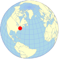
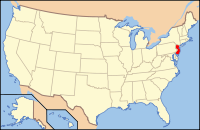
Geography of New Jersey
Encyclopedia
New York
New York is a state in the Northeastern region of the United States. It is the nation's third most populous state. New York is bordered by New Jersey and Pennsylvania to the south, and by Connecticut, Massachusetts and Vermont to the east...
along the north, ratified by both states after the New York – New Jersey Line War
New York – New Jersey Line War
The New York – New Jersey Line War refers to a series of skirmishes and raids that took place for over half a century between 1701 and 1765 at the disputed border between two American colonies, the Province of New York and the Province of New Jersey.Border wars were not unusual in the early days...
.
Along the east, New Jersey is flanked by the Atlantic Ocean
Atlantic Ocean
The Atlantic Ocean is the second-largest of the world's oceanic divisions. With a total area of about , it covers approximately 20% of the Earth's surface and about 26% of its water surface area...
. It is separated from New York, in particular the boroughs of the Bronx and Manhattan
Manhattan
Manhattan is the oldest and the most densely populated of the five boroughs of New York City. Located primarily on the island of Manhattan at the mouth of the Hudson River, the boundaries of the borough are identical to those of New York County, an original county of the state of New York...
in New York City
New York City
New York is the most populous city in the United States and the center of the New York Metropolitan Area, one of the most populous metropolitan areas in the world. New York exerts a significant impact upon global commerce, finance, media, art, fashion, research, technology, education, and...
by the Hudson River
Hudson River
The Hudson is a river that flows from north to south through eastern New York. The highest official source is at Lake Tear of the Clouds, on the slopes of Mount Marcy in the Adirondack Mountains. The river itself officially begins in Henderson Lake in Newcomb, New York...
, and from Staten Island
Staten Island
Staten Island is a borough of New York City, New York, United States, located in the southwest part of the city. Staten Island is separated from New Jersey by the Arthur Kill and the Kill Van Kull, and from the rest of New York by New York Bay...
by the Kill van Kull
Kill Van Kull
The Kill Van Kull is a tidal strait between Staten Island, New York and Bayonne, New Jersey in the United States. Approximately long and wide, it connects Newark Bay with Upper New York Bay. The Robbins Reef Light marks the eastern end of the Kill, Bergen Point its western end...
and the Arthur Kill
Arthur Kill
The Arthur Kill is a tidal strait separating Staten Island, New York from mainland New Jersey, USA, and a major navigational channel of the Port of New York and New Jersey. Kill is from the Middle Dutch word kille, meaning "riverbed" or "water channel"...
. Liberty Island
Liberty Island
Liberty Island is a small uninhabited island in New York Harbor in the United States, best known as the location of the Statue of Liberty. Though so called since the turn of the century, the name did not become official until 1956. In 1937, by proclamation 2250, President Franklin D...
is a exclave of State of New York in New Jersey
New Jersey
New Jersey is a state in the Northeastern and Middle Atlantic regions of the United States. , its population was 8,791,894. It is bordered on the north and east by the state of New York, on the southeast and south by the Atlantic Ocean, on the west by Pennsylvania and on the southwest by Delaware...
waters in Upper New York Bay
Upper New York Bay
Upper New York Bay, or Upper Bay, is the traditional heart of the Port of New York and New Jersey, and often called New York Harbor. It is enclosed by the New York City boroughs of Manhattan, Brooklyn, and Staten Island and the Hudson County, New Jersey municipalities of Jersey City and Bayonne.It...
. Ellis Island
Ellis Island
Ellis Island in New York Harbor was the gateway for millions of immigrants to the United States. It was the nation's busiest immigrant inspection station from 1892 until 1954. The island was greatly expanded with landfill between 1892 and 1934. Before that, the much smaller original island was the...
, also in the Upper Bay, and Shooter's Island, in Newark Bay
Newark Bay
Newark Bay is a tidal bay at the confluence of the Passaic and Hackensack Rivers in northeastern New Jersey. It is home to the Port Newark-Elizabeth Marine Terminal, the largest container shipping facility in Port of New York and New Jersey, 3rd largest and one of busiest in the United States...
, each have sections belonging to either of the two states.
On its west, New Jersey is flanked by the Delaware River
Delaware River
The Delaware River is a major river on the Atlantic coast of the United States.A Dutch expedition led by Henry Hudson in 1609 first mapped the river. The river was christened the South River in the New Netherland colony that followed, in contrast to the North River, as the Hudson River was then...
that forms its border with the Commonwealth of Pennsylvania
Pennsylvania
The Commonwealth of Pennsylvania is a U.S. state that is located in the Northeastern and Mid-Atlantic regions of the United States. The state borders Delaware and Maryland to the south, West Virginia to the southwest, Ohio to the west, New York and Ontario, Canada, to the north, and New Jersey to...
and Delaware Bay
Delaware Bay
Delaware Bay is a major estuary outlet of the Delaware River on the Northeast seaboard of the United States whose fresh water mixes for many miles with the waters of the Atlantic Ocean. It is in area. The bay is bordered by the State of New Jersey and the State of Delaware...
which separates New Jersey from the State of Delaware
Delaware
Delaware is a U.S. state located on the Atlantic Coast in the Mid-Atlantic region of the United States. It is bordered to the south and west by Maryland, and to the north by Pennsylvania...
. However, due to a fluke in a colonial land grant for the city of New Castle, Delaware
New Castle, Delaware
New Castle is a city in New Castle County, Delaware, six miles south of Wilmington, situated on the Delaware River. In 1900, 3,380 people lived here; in 1910, 3,351...
(called The Twelve-Mile Circle
The Twelve-Mile Circle
The Twelve-Mile Circle is an approximately circular arc which forms most of the boundary between the Commonwealth of Pennsylvania and the State of Delaware in the United States...
), there is a small amount of Delaware territory continguous New Jersey. Finns Point, piers at Penns Grove
Penns Grove, New Jersey
Penns Grove is a Borough in Salem County, New Jersey, United States. As of the 2000 United States Census, the borough population was 4,886.Penns Grove was incorporated as a borough by an Act of the New Jersey Legislature on March 8, 1894, from portions of Upper Penns Neck Township Penns Grove is a...
and Pennsville, and Artificial Island, the tip of a small peninsula at Lower Alloways Creek
Lower Alloways Creek Township, New Jersey
Lower Alloways Creek Township is a Township in Salem County, New Jersey, United States. As of the United States 2000 Census, the township population was 1,851....
are connected to Salem County
Salem County, New Jersey
-Demographics:As of the census of 2000, there were 64,285 people, 24,295 households, and 17,370 families residing in the county. The population density was 190 people per square mile . There were 26,158 housing units at an average density of 77 per square mile...
. A coal pier
Coal pier
A coal pier is a transloading facility designed for the transfer of coal between rail and ship.The typical facility for loading ships consists of a holding area and a system of conveyors for transferring the coal to dockside and loading it into the ship's cargo holds...
in Logan Township
Logan Township, New Jersey
Logan Township is a township in Gloucester County, New Jersey, United States. As of the United States 2000 Census, the township population was 6,032....
also extend into the river.
Area
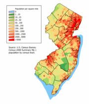
Due to its small size, New Jersey, which ranks tenth in the nation in terms of population with 8,414,350 people, ranks first in population density, with 1,134 people per square mile. However, while this offers the impression that New Jersey is entirely urban or suburban, it is not. Large swaths of northwestern and southern New Jersey are extremely rural. For example, Walpack Township
Walpack Township, New Jersey
-Local government:Walpack Township is governed under the Township form of government with a three-member Township Committee. The Township Committee is elected directly by the voters in partisan elections to serve three-year terms of office on a staggered basis, with one seat coming up for election...
in Sussex County
Sussex County, New Jersey
The County of Sussex is the northernmost county in the State of New Jersey. It is part of the New York City Metropolitan Area. As of the 2010 Federal decennial census, 149,265 persons resided in Sussex County...
, has a population of only 39 and an area of 26 square miles (67.3 km²).
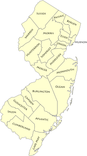
Political geography
Municipality
A municipality is essentially an urban administrative division having corporate status and usually powers of self-government. It can also be used to mean the governing body of a municipality. A municipality is a general-purpose administrative subdivision, as opposed to a special-purpose district...
. Like many New England
New England town
The New England town is the basic unit of local government in each of the six New England states. Without a direct counterpart in most other U.S. states, New England towns are conceptually similar to civil townships in other states, but are incorporated, possessing powers like cities in other...
states, all land in New Jersey is incorporated. New Jersey municipalities have a strong tradition of independent home rule
Home rule
Home rule is the power of a constituent part of a state to exercise such of the state's powers of governance within its own administrative area that have been devolved to it by the central government....
which, as a result, means that county government is comparatively weaker than in other states and more open to criticisms of waste and ineffectiveness.
Climate
Most of New Jersey has a humid mesothermalMesothermal
In climatology, the term mesothermal is used to refer to certain forms of climate found typically in the Earth's Temperate Zones. It has a moderate amount of heat, with winters not cold enough to sustain snow cover...
climate while a humid continental climate
Humid continental climate
A humid continental climate is a climatic region typified by large seasonal temperature differences, with warm to hot summers and cold winters....
(Microthermal
Microthermal
In climatology, the term microthermal is used to denote the continental climates of Eurasia and North America.The word microthermal is derived from two Greek words meaning "having little heat." This is misleading, however, since the term is intended to describe only the temperature conditions that...
Climate) prevails in the northwest, according to the Koppen climate classification
Köppen climate classification
The Köppen climate classification is one of the most widely used climate classification systems. It was first published by Crimea German climatologist Wladimir Köppen in 1884, with several later modifications by Köppen himself, notably in 1918 and 1936...
. New Jersey's climate is vastly affected by its proximity to the Atlantic Ocean
Atlantic Ocean
The Atlantic Ocean is the second-largest of the world's oceanic divisions. With a total area of about , it covers approximately 20% of the Earth's surface and about 26% of its water surface area...
.
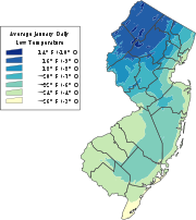
- Winter is typically cold. The lows usually hover in the 10s and 20s °F (down to -10 °C) and can frequently dip below 0 °F (-17.8 °C) in the northwestern sections of the state. New Jersey winters often feature snowstorms known as Nor'easterNor'easterA nor'easter is a type of macro-scale storm along the East Coast of the United States and Atlantic Canada, so named because the storm travels to the northeast from the south and the winds come from the northeast, especially in the coastal areas of the Northeastern United States and Atlantic Canada...
s that can paralyze the area with over a foot of snow. However, a variation in the climate also occasionally renders winter mild and almost snowless in sections of South Jersey near the Atlantic coastline.
- Springs are mild, averaging in the 50s °F (10 to 15 °C) in late March to the lower 80s °F (25-30 °C) in early June. The weather is unpredictable and brings relatively cool summers as an occasional surprise, and huge snowstorms arriving as late as the second week in April (significant snow after mid-March is fairly rare though). Thunderstorms are common in spring.
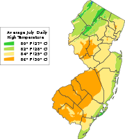
- Summers in New Jersey tend to be hot and humid, with temperatures often exceeding 90 °F (32 °C), although high temperatures above 100 °F (38 °C) are uncommon. Humidity levels are usually quite high in July and August. Thunderstorms are common in summer. Hurricanes are considered to be a major threat to the area (and especially the Jersey Shoreline communities in MonmouthMonmouth County, New JerseyMonmouth County is a county located in the U.S. state of New Jersey, within the New York metropolitan area. As of the 2010 Census, the population was 630,380, up from 615,301 at the 2000 census. Its county seat is Freehold Borough. The most populous municipality is Middletown Township with...
, OceanOcean County, New Jersey-Demographics:As of the census of 2000, there were 510,916 people, 200,402 households, and 137,876 families residing in the county. The population density was 803 people per square mile . There were 248,711 housing units at an average density of 151/km²...
, AtlanticAtlantic County, New Jersey-National protected areas:* Edwin B. Forsythe National Wildlife Refuge * Great Egg Harbor Scenic and Recreational River -Demographics:...
and Cape MayCape May County, New Jersey-Climate:Being the southernmost point in New Jersey, Cape May has fairly mild wintertime temperatures. Contrary to that, the summertime has lower temperatures than most places in the state, making the county a popular place to escape the heat. It is in zone 7a/7b, which is the same as parts of...
counties). While relatively infrequent compared to areas south and east, a direct hit could cause large loss of life and billions of dollars in damage due to the high population in coastal areas.
- Autumns are comfortable in New Jersey and similar to spring in temperature. However, the weather is notably unpredictable and travelers are advised to check forecasts and bring several layers of clothing in late fall and in the early spring months (e.g., November, March, April) as temperatures do fluctuate quickly at these times of year.
The temperatures vary greatly from the northernmost part of New Jersey to the southernmost part of New Jersey. For example, these are the average high and low temperatures for Cape May
Cape May, New Jersey
Cape May is a city at the southern tip of Cape May Peninsula in Cape May County, New Jersey, where the Delaware Bay meets the Atlantic Ocean and is one of the country's oldest vacation resort destinations. It is part of the Ocean City Metropolitan Statistical Area. As of the 2010 United States...
, near the state's southernmost ocean-facing point, Sussex
Sussex, New Jersey
Sussex is a borough in Sussex County, New Jersey, United States. As of the 2010 census, the borough population was 2,130.Sussex was incorporated as a borough by an act of the New Jersey Legislature on October 14, 1891, as Deckertown, from portions of Wantage...
, in the mountainous northwest, and Trenton, the state capital located roughly midway between the two:
| Sussex | Trenton | Cape May | ||||
|---|---|---|---|---|---|---|
| High | Low | High | Low | High | Low | |
| January | 34 | 14 | 38 | 24 | 42 | 27 |
| February | 38 | 16 | 41 | 26 | 43 | 28 |
| March | 47 | 25 | 51 | 33 | 51 | 35 |
| April | 59 | 35 | 61 | 42 | 60 | 43 |
| May | 70 | 45 | 71 | 52 | 69 | 53 |
| June | 78 | 54 | 80 | 61 | 78 | 62 |
| July | 83 | 59 | 85 | 67 | 84 | 67 |
| August | 82 | 57 | 83 | 65 | 83 | 66 |
| September | 74 | 49 | 75 | 57 | 77 | 60 |
| October | 63 | 37 | 64 | 45 | 66 | 49 |
| November | 51 | 30 | 54 | 37 | 56 | 40 |
| December | 39 | 21 | 43 | 28 | 47 | 31 |
| (Temperatures above are Fahrenheit) Data source: |
||||||
Rivers
New Jersey rivers includes streams formally designated as riverRiver
A river is a natural watercourse, usually freshwater, flowing towards an ocean, a lake, a sea, or another river. In a few cases, a river simply flows into the ground or dries up completely before reaching another body of water. Small rivers may also be called by several other names, including...
s. There are also smaller streams (i.e., branches, creeks, drains, forks, licks, runs, etc.) in the state. Major rivers include the Manasquan
Manasquan River
The Manasquan River is a waterway in central New Jersey. It flows from central Monmouth County, beginning in Freehold Township, to the Atlantic Ocean, where it empties between the communities of Manasquan and Point Pleasant via the Manasquan Inlet. It widens greatly as it nears the ocean, making...
, Maurice
Maurice River
The Maurice River is a river that empties into the Delaware Bay in southern New Jersey in the United States.The Maurice River, pronounced "Morris", is approximately long and is the second longest and largest tributary to Delaware Bay. Its watershed includes an extensive southern portion of the...
, Mullica
Mullica River
The Mullica River is a river in southern New Jersey in the United States. The Mullica was once known as the Little Egg Harbor River.The river provides one of the principal drainages into the Atlantic Ocean of the extensive Pinelands...
, Passaic
Passaic River
The Passaic River is a mature surface river, approximately 80 mi long, in northern New Jersey in the United States. The river in its upper course flows in a highly circuitous route, meandering through the swamp lowlands between the ridge hills of rural and suburban northern New Jersey,...
, Rahway
Rahway River
The Rahway River is a river, approximately 24 mi long, in northeastern New Jersey in the United States. The river drains part of the suburban and urbanized area of New Jersey west of New York City. Part of the extended area of New York Harbor, the river empties into the Arthur Kill. In its...
, Raritan
Raritan River
The Raritan River is a major river of central New Jersey in the United States. Its watershed drains much of the mountainous area of the central part of the state, emptying into the Raritan Bay on the Atlantic Ocean.-Description:...
, Musconetcong
Musconetcong River
The Musconetcong River is a tributary of the Delaware River in northwestern New Jersey in the United States. It flows through the rural mountainous country of northwestern New Jersey. Part of it is a National Wild and Scenic River....
, and Delaware
Delaware River
The Delaware River is a major river on the Atlantic coast of the United States.A Dutch expedition led by Henry Hudson in 1609 first mapped the river. The river was christened the South River in the New Netherland colony that followed, in contrast to the North River, as the Hudson River was then...
rivers. Historically, the Delaware and Raritan rivers have provided transportation of goods and people inland from the Atlantic Ocean
Atlantic Ocean
The Atlantic Ocean is the second-largest of the world's oceanic divisions. With a total area of about , it covers approximately 20% of the Earth's surface and about 26% of its water surface area...
, and were once connected by the Delaware and Raritan Canal
Delaware and Raritan Canal
The Delaware and Raritan Canal is a canal in central New Jersey, United States, built in the 1830s that served to connect the Delaware River to the Raritan River. It was intended as an efficient and reliable means of transportation of freight between Philadelphia, Pennsylvania and New York City,...
. Today, these rivers, and the streams that feed them, provide sport and recreation for many people. The Raritan River in Middlesex County
Middlesex County, New Jersey
-Demographics:As of the census of 2000, there were 750,162 people, 265,815 households, and 190,855 families residing in the county. The population density was 2,422 people per square mile . There were 273,637 housing units at an average density of 884 per square mile...
is often considered the borderline between North and South/Central Jersey, although it is not official.
Geology
Around 250 million years ago, during the PaleozoicPaleozoic
The Paleozoic era is the earliest of three geologic eras of the Phanerozoic eon, spanning from roughly...
and Mesozoic
Mesozoic
The Mesozoic era is an interval of geological time from about 250 million years ago to about 65 million years ago. It is often referred to as the age of reptiles because reptiles, namely dinosaurs, were the dominant terrestrial and marine vertebrates of the time...
eras, the area that is today New Jersey bordered northern Africa as part of the supercontinent
Supercontinent
In geology, a supercontinent is a landmass comprising more than one continental core, or craton. The assembly of cratons and accreted terranes that form Eurasia qualifies as a supercontinent today.-History:...
of Pangea. The pressure of the collision between North America and Africa gave rise to the Appalachian Mountains
Appalachian Mountains
The Appalachian Mountains #Whether the stressed vowel is or ,#Whether the "ch" is pronounced as a fricative or an affricate , and#Whether the final vowel is the monophthong or the diphthong .), often called the Appalachians, are a system of mountains in eastern North America. The Appalachians...
. Around 180 million years ago, Pangea began to break apart, separating the North American continent from the African continent. Around 18,000 years ago, the most recent ice age resulted in glaciers that reached New Jersey. As the glaciers retreated, they left behind Lake Passaic
Glacial Lake Passaic
Glacial Lake Passaic was a prehistoric proglacial lake that existed in northern New Jersey in the United States at the end of the last ice age approximately 19,000-14,000 years ago...
, as well as many rivers, swamps, and gorges.
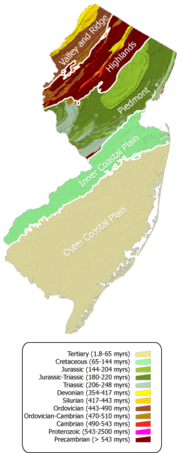
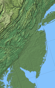
Physiographic Provinces
New Jersey
New Jersey is a state in the Northeastern and Middle Atlantic regions of the United States. , its population was 8,791,894. It is bordered on the north and east by the state of New York, on the southeast and south by the Atlantic Ocean, on the west by Pennsylvania and on the southwest by Delaware...
is a region with a high variety of geographical features in a small area. The area can be broken into five regions, corresponding roughly to geological zones. These regions from north to south are the Appalachian Valley and Ridge, Highlands, Newark Basin Piedmont, Inner Coastal Plain, and the Outer Coastal Plain.
Appalachian Valley and Ridge Physiographic Province
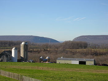
Kittatinny Mountains
The Kittatinny Mountains are a long ridge traversing across northwestern New Jersey running in a northeast-southwest axis. It is the first major ridge in the far northeastern extension of the Ridge and Valley province of the Appalachian Mountains...
, several smaller valleys and the popular Delaware Water Gap
Delaware Water Gap
The Delaware Water Gap is on the border of New Jersey and Pennsylvania where the Delaware River cuts through a large ridge of the Appalachian Mountains...
. The state's highest point, the aptly named High Point is within this area, at 1803 feet (549.6 m). Most of the state's section of the Appalachian Trail
Appalachian Trail
The Appalachian National Scenic Trail, generally known as the Appalachian Trail or simply the AT, is a marked hiking trail in the eastern United States extending between Springer Mountain in Georgia and Mount Katahdin in Maine. It is approximately long...
runs through this area. The province is bounded on the southeast by an unconformity
Unconformity
An unconformity is a buried erosion surface separating two rock masses or strata of different ages, indicating that sediment deposition was not continuous. In general, the older layer was exposed to erosion for an interval of time before deposition of the younger, but the term is used to describe...
between Cambrian
Cambrian
The Cambrian is the first geological period of the Paleozoic Era, lasting from Mya ; it is succeeded by the Ordovician. Its subdivisions, and indeed its base, are somewhat in flux. The period was established by Adam Sedgwick, who named it after Cambria, the Latin name for Wales, where Britain's...
and Precambrian
Precambrian
The Precambrian is the name which describes the large span of time in Earth's history before the current Phanerozoic Eon, and is a Supereon divided into several eons of the geologic time scale...
formations.
Highlands Physiographic Province
The Highlands Physiographic Province is a geological formation composed primarily of PrecambrianPrecambrian
The Precambrian is the name which describes the large span of time in Earth's history before the current Phanerozoic Eon, and is a Supereon divided into several eons of the geologic time scale...
igneous and metamorphic rock
Metamorphic rock
Metamorphic rock is the transformation of an existing rock type, the protolith, in a process called metamorphism, which means "change in form". The protolith is subjected to heat and pressure causing profound physical and/or chemical change...
running from the Delaware River
Delaware River
The Delaware River is a major river on the Atlantic coast of the United States.A Dutch expedition led by Henry Hudson in 1609 first mapped the river. The river was christened the South River in the New Netherland colony that followed, in contrast to the North River, as the Hudson River was then...
near Musconetcong Mountain, northeast through the Skylands Region
Skylands Region
The Skylands Region is a marketing area of the State of New Jersey located in the Northern and Central part of the state. It is one of six tourism regions established by the New Jersey State Department of Tourism, the others being the Gateway Region, Greater Atlantic City Region, the Southern...
of New Jersey
New Jersey
New Jersey is a state in the Northeastern and Middle Atlantic regions of the United States. , its population was 8,791,894. It is bordered on the north and east by the state of New York, on the southeast and south by the Atlantic Ocean, on the west by Pennsylvania and on the southwest by Delaware...
along the Bearfort Ridge and the Ramapo Mountains
Ramapo Mountains
The Ramapo Mountains are a forested chain of the Appalachian mountains in northeastern New Jersey and southeastern New York in the United States...
. Numerous abandoned mines dot the region, dating from the 18th and 19th centuries when iron, copper, zinc and other minerals were extracted from the formations. The glaciated northern half of the province has an abundance of lakes and reservoirs which serve as water supplies for the urban areas to the east. The region's watershed is protected by the Highlands Water Protection and Planning Act
Highlands Water Protection and Planning Act
The Highlands Water Protection and Planning Act is a 2004 New Jersey law aimed at protecting the Highlands region of northwest New Jersey by regulating development within the region under the supervision of the New Jersey Department of Environmental Protection. The Highland region covers , nearly...
.
Newark Basin Piedmont
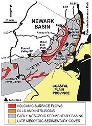
Newark Basin
The Newark Basin is a sediment-filled rift basin located mainly in northern New Jersey but also stretching into south-eastern Pennsylvania and southern New York. It is part of the system of Eastern North America Rift Basins.-Geology:...
is a region in northern New Jersey defined by the boundaries of a sediment
Sediment
Sediment is naturally occurring material that is broken down by processes of weathering and erosion, and is subsequently transported by the action of fluids such as wind, water, or ice, and/or by the force of gravity acting on the particle itself....
-filled rift basin
Rift
In geology, a rift or chasm is a place where the Earth's crust and lithosphere are being pulled apart and is an example of extensional tectonics....
. This basin was formed when the supercontinent
Supercontinent
In geology, a supercontinent is a landmass comprising more than one continental core, or craton. The assembly of cratons and accreted terranes that form Eurasia qualifies as a supercontinent today.-History:...
Pangaea
Pangaea
Pangaea, Pangæa, or Pangea is hypothesized as a supercontinent that existed during the Paleozoic and Mesozoic eras about 250 million years ago, before the component continents were separated into their current configuration....
began to split approximately 220 million years ago, causing several large depressions to form due to extension, which then filled with sediment. The basin itself extends from Rockland County
Rockland County, New York
Rockland County is a suburban county 15 miles to the northwest of Manhattan and part of the New York City Metropolitan Area, in the U.S. state of New York. It is the southernmost county in New York west of the Hudson River, and the smallest county in New York outside of New York City. The...
in the southern tip of New York
New York
New York is a state in the Northeastern region of the United States. It is the nation's third most populous state. New York is bordered by New Jersey and Pennsylvania to the south, and by Connecticut, Massachusetts and Vermont to the east...
to south-eastern Pennsylvania
Pennsylvania
The Commonwealth of Pennsylvania is a U.S. state that is located in the Northeastern and Mid-Atlantic regions of the United States. The state borders Delaware and Maryland to the south, West Virginia to the southwest, Ohio to the west, New York and Ontario, Canada, to the north, and New Jersey to...
. It lies within the broader region known as the Piedmont
Piedmont (United States)
The Piedmont is a plateau region located in the eastern United States between the Atlantic Coastal Plain and the main Appalachian Mountains, stretching from New Jersey in the north to central Alabama in the south. The Piedmont province is a physiographic province of the larger Appalachian division...
, a crescent-shaped area characterized by smooth topography
Topography
Topography is the study of Earth's surface shape and features or those ofplanets, moons, and asteroids...
and large volumes of sediments. Like the Piedmont, the Newark Basin has gentle topography consisting of red bed clastic sediments with occasional igneous rock
Igneous rock
Igneous rock is one of the three main rock types, the others being sedimentary and metamorphic rock. Igneous rock is formed through the cooling and solidification of magma or lava...
formations, such as the Palisades Sill
Palisades Sill
The Palisades Sill is a Triassic, 200 Ma diabase intrusion. It extends through portions of New York and New Jersey. It is most noteworthy for The Palisades, the cliffs that rise steeply above the western bank of the Hudson River...
and the Watchung basalt
Basalt
Basalt is a common extrusive volcanic rock. It is usually grey to black and fine-grained due to rapid cooling of lava at the surface of a planet. It may be porphyritic containing larger crystals in a fine matrix, or vesicular, or frothy scoria. Unweathered basalt is black or grey...
flows; these igneous features are responsible for the dramatic elevation changes observed in the region, such as The Palisades
New Jersey Palisades
The Palisades, also called the New Jersey Palisades or the Hudson Palisades are a line of steep cliffs along the west side of the lower Hudson River in northeastern New Jersey and southern New York in the United States. The cliffs stretch north from Jersey City approximately 20 mi to near...
and the Watchung Mountains
Watchung Mountains
The Watchung Mountains are a group of three long low ridges of volcanic origin, between 400 ft. and 500 ft. high, lying parallel to each other in northern New Jersey in the United States...
, respectively. The boundaries of the Newark Basin, as well as major highways, are shown on the map at left.
For the geological history of the region, see Newark Basin
Newark Basin
The Newark Basin is a sediment-filled rift basin located mainly in northern New Jersey but also stretching into south-eastern Pennsylvania and southern New York. It is part of the system of Eastern North America Rift Basins.-Geology:...
.
Inner Coastal Plain
The Inner Coastal Plain province consists of lowlands and rolling hills underlain by CretaceousCretaceous
The Cretaceous , derived from the Latin "creta" , usually abbreviated K for its German translation Kreide , is a geologic period and system from circa to million years ago. In the geologic timescale, the Cretaceous follows the Jurassic period and is followed by the Paleogene period of the...
deposits. Surficial geology in this region contains a number of fossils. The Monmouth County Park system, for example, includes a number of creeks where students and enthusiasts can gain real field exposure to cretaceous geology and paleontology. (Always check with the park service staff regarding permissibility before entering any field site.) The region's northwest border lies along the Piedmont fall line
Fall line
A fall line is a geomorphologic unconformity between an upland region of relatively hard crystalline basement rock and a coastal plain of softer sedimentary rock. A fall line is typically prominent when crossed by a river, for there will often be rapids or waterfalls...
. Fertile, loamy soil makes the land ideal for agriculture and is responsible for New Jersey's nickname of the "Garden State". Its deposits of Greensand
Greensand
Greensand or Green sand is either a sand or sandstone, which has a greenish color. This term is specifically applied to shallow marine sediment, that contains noticeable quantities of rounded greenish grains. These grains are called glauconies and consist of a mixture of mixed-layer clay...
marl containing potash were used since colonial days by farmers to fertilize their fields.
Outer Coastal Plain
The outer coastal plain consists of unconsolidated Tertiary deposits of sands, silt, and gravels. The soils are sandy with less clay than the inner coastal plain, and are more acidic and dry. The lack of fertility makes much of the region unsuitable for agriculture and large areas remain undeveloped. The sandy Pine BarrensPine Barrens (New Jersey)
The Pine Barrens, also known as the Pinelands, is a heavily forested area of coastal plain stretching across southern New Jersey. The name "pine barrens" refers to the area's sandy, acidic, nutrient-poor soil, to which the crops originally imported by European settlers didn't take well...
, an area that is agriculturally poor but species rich, occupy the center of the province. Blueberries and cranberries have been cultivated in lowland bogs that have accumulated depths of organic matter.
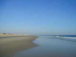
Along the coast, sandy beaches attract a recreation industry, and the offshore barrier island
Barrier island
Barrier islands, a coastal landform and a type of barrier system, are relatively narrow strips of sand that parallel the mainland coast. They usually occur in chains, consisting of anything from a few islands to more than a dozen...
s are popular vacation destinations.
Natural environment
New Jersey's natural environment preserves a range of habitats ranging from the Atlantic shore to the Appalachian Mountains. The sandy uplands of South Jersey are home to the Atlantic coastal pine barrensAtlantic coastal pine barrens
The Atlantic coastal pine barrens is a temperate coniferous forests ecoregion of the northeastern United States.-Setting:This ecoregion covers a disjunct area of 8,975 km² including the New Jersey Pine Barrens on the coastal plain of New Jersey, and smaller areas of southern Long Island in New...
. Surrounding the Pine Barrens, along the coast and covering the Inner Coastal Plain and Piedmont, are the Northeastern coastal forests
Northeastern coastal forests
The Northeastern coastal forests are a temperate broadleaf and mixed forests ecoregion of the northeastern United States. The ecoregion covers an area of 34,630 sq miles encompassing the Piedmont and coastal plain of seven states, extending from northern Maryland and Delaware through southeast...
. The Highlands consist of Appalachian-Blue Ridge forests
Appalachian-Blue Ridge forests
The Appalachian-Blue Ridge Forests is a temperate broadleaf and mixed forests ecoregion of the Eastern United States, delineated by the World Wide Fund for Nature.-Setting:...
which grade into Allegheny Highlands forests
Allegheny Highlands forests
The Allegheny Highlands forests are a temperate broadleaf and mixed forests ecoregion of North America.-Setting:The ecoregion consists of four separate blocks of mixed forest surrounded by lower lying areas of hardwood forest as follows: the Northern Allegheny Plateau in New York State and...
in the far northeast.
Tourist Regions
New Jersey State Department of Tourism distinguishes six distinct tourist regions: the GatewayGateway Region
The Gateway Region is located in the northeastern part of State of New Jersey in the United States of America. The area encompasses Bergen, Essex, Hudson, Passaic, Union and Middlesex counties...
, Greater Atlantic City
Atlantic County, New Jersey
-National protected areas:* Edwin B. Forsythe National Wildlife Refuge * Great Egg Harbor Scenic and Recreational River -Demographics:...
, the Southern Shore Region
Southern Shore Region
The Southern Shore Region is located in the southeastern part of State of New Jersey in the United States of America. It is one of six tourism regions established by the New Jersey State Department of Tourism, the others being the Gateway Region, Greater Atlantic City, the Delaware River Region,...
, the Delaware River Region
Delaware River Region
The Delaware River Region refers to an area in western New Jersey along the Delaware River border with Pennsylvania. It encompasses Burlington County, Camden County, Gloucester County, Mercer County, and Salem County. The area is primarily part of Greater Philadelphia with the exception of Mercer...
, the Shore Region
Jersey Shore
The Jersey Shore is a term used to refer to both the Atlantic coast of the U.S. state of New Jersey and the adjacent resort and residential communities. . The New Jersey State Department of Tourism considers the Shore Region, Greater Atlantic City, and the Southern Shore to be distinct, each having...
and the Skylands Region
Skylands Region
The Skylands Region is a marketing area of the State of New Jersey located in the Northern and Central part of the state. It is one of six tourism regions established by the New Jersey State Department of Tourism, the others being the Gateway Region, Greater Atlantic City Region, the Southern...
.
New Jersey's ethnic communities today
- New Jersey has one of the fastest growing Asian AmericanAsian AmericanAsian Americans are Americans of Asian descent. The U.S. Census Bureau definition of Asians as "Asian” refers to a person having origins in any of the original peoples of the Far East, Southeast Asia, or the Indian subcontinent, including, for example, Cambodia, China, India, Indonesia, Japan,...
communities in the United States. - Along with the increase in the population of Asian immigrants and their posterity, steady populations of European Americans have remained large since their immigration into New York during the 18th, 19th and 20th Century and their movement westward, the largest of this ancestry groups being Italians, Irish, German and Polish.
Regional cultural divisions
Although it is a small state, New Jersey has significant regional cultural divisions. South JerseySouth Jersey
South Jersey comprises the southern portions of the U.S. state of New Jersey between the lower Delaware River and the Atlantic Ocean. The designation is a colloquial one, reflecting not only geographical but perceived cultural differences from the northern part of the state, with no official...
culture is influenced by its proximity to Philadelphia as well as its extensive shore and beaches
Jersey Shore
The Jersey Shore is a term used to refer to both the Atlantic coast of the U.S. state of New Jersey and the adjacent resort and residential communities. . The New Jersey State Department of Tourism considers the Shore Region, Greater Atlantic City, and the Southern Shore to be distinct, each having...
. North Jersey
North Jersey
North Jersey is a colloquial term, with no precise consensus definition, for the northern portion of the U.S. state of New Jersey. A straightforward, noncolloquial term for the region is northern New Jersey.- Two-portion approaches :...
culture (particularly northeastern New Jersey) is influenced by its proximity to New York City
New York City
New York is the most populous city in the United States and the center of the New York Metropolitan Area, one of the most populous metropolitan areas in the world. New York exerts a significant impact upon global commerce, finance, media, art, fashion, research, technology, education, and...
. Sandwiched in between are the towns of Central Jersey
Central Jersey
Central Jersey is a common designation for a region of the state of New Jersey in the United States of America. Trenton is considered the boundary between designated "North Jersey" and "South Jersey"...
, which are more suburban than their northern counterparts but much less rural than towns in the south.
See also
- Geography of New York HarborGeography of New York HarborThe system of waterways of the Port of New York and New Jersey forms one of the most intricate natural harbors in the world, a fact that is reflected in the diversity of place names...
- Geography of the United StatesGeography of the United StatesThe United States is a country in the Western Hemisphere. It consists of forty-eight contiguous states in North America, Alaska, a peninsula which forms the northwestern most part of North America, and Hawaii, an archipelago in the Pacific Ocean. There are several United States territories in the...
- History of New JerseyHistory of New JerseyThe history of New Jersey began at the end of the Younger Dryas climate, about 10 millennia ago. Native Americans moved into New Jersey soon after the reversal of the Younger Dryas, which had made the area uninhabitable and, during the preceding ice age, unreachable.European contact began with the...
- List of New Jersey rivers
- New JerseyNew JerseyNew Jersey is a state in the Northeastern and Middle Atlantic regions of the United States. , its population was 8,791,894. It is bordered on the north and east by the state of New York, on the southeast and south by the Atlantic Ocean, on the west by Pennsylvania and on the southwest by Delaware...