

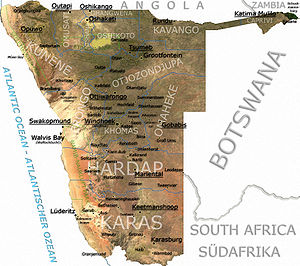
Geography of Namibia
Encyclopedia
Venezuela
Venezuela , officially called the Bolivarian Republic of Venezuela , is a tropical country on the northern coast of South America. It borders Colombia to the west, Guyana to the east, and Brazil to the south...
). After Mongolia
Mongolia
Mongolia is a landlocked country in East and Central Asia. It is bordered by Russia to the north and China to the south, east and west. Although Mongolia does not share a border with Kazakhstan, its western-most point is only from Kazakhstan's eastern tip. Ulan Bator, the capital and largest...
, Namibia is the least densely populated country in the world (2.5 PD/sqkm).
Geographical areas
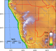
The Namibian landscape consists generally of five geographical areas, each with characteristic abiotic conditions and vegetation with some variation within and overlap between them: the Central Plateau, the Namib DesertNamib Desert
The Namib Desert is a desert in Namibia and southwest Angola that forms part of the Namib-Naukluft National Park, the largest game reserve in Africa. The name "Namib" is of Nama origin and means "vast place"...
, the Great Escarpment
Great Escarpment
The Great Escarpment is a mountainous escarpment in southern Africa. While it lies predominantly within the borders of Lesotho and South Africa, it also extends into Angola, Namibia, Swaziland, Mozambique, and Zimbabwe....
, the Bushveld
Bushveld
The Bushveld is a sub-tropical woodland ecoregion of Southern Africa that encompasses most of Limpopo Province and a small part of the North West Province of South Africa, the Central and North-East Districts of Botswana and the Matabeleland South and part of th Matabeleland North provinces of...
, and the Kalahari Desert
Kalahari Desert
The Kalahari Desert is a large semi-arid sandy savannah in Southern Africa extending , covering much of Botswana and parts of Namibia and South Africa, as semi-desert, with huge tracts of excellent grazing after good rains. The Kalahari supports more animals and plants than a true desert...
.
Central Plateau
The Central Plateau runs from north to south, bordered by the Skeleton CoastSkeleton Coast
The Skeleton Coast is the northern part of the Atlantic Ocean coast of Namibia and south of Angola from the Kunene River south to the Swakop River, although the name is sometimes used to describe the entire Namib Desert coast...
to the northwest, the Namib Desert and its coastal plains to the southwest, the Orange River
Orange River
The Orange River , Gariep River, Groote River or Senqu River is the longest river in South Africa. It rises in the Drakensberg mountains in Lesotho, flowing westwards through South Africa to the Atlantic Ocean...
to the south, and the Kalahari Desert to the east. The Central Plateau is home to the highest point in Namibia at Königstein elevation 2606 metres (8,550 ft). Within the wide, flat Central Plateau is the majority of Namibia’s population and economic activity. Windhoek
Windhoek
Windhoek is the capital and largest city of the Republic of Namibia. It is located in central Namibia in the Khomas Highland plateau area, at around above sea level. The 2001 census determined Windhoek's population was 233,529...
, the nation’s capital, is located here, as well as most of the arable land. Although arable land accounts for only 1% of Namibia, nearly half of the population is employed in agriculture.
The abiotic conditions here are similar to those found along the Escarpment; however the topographic complexity is reduced. Summer temperatures in the area can reach 40 °C (104 °F), and frosts are common in the winter.
Namib Desert
The Namib DesertNamib Desert
The Namib Desert is a desert in Namibia and southwest Angola that forms part of the Namib-Naukluft National Park, the largest game reserve in Africa. The name "Namib" is of Nama origin and means "vast place"...
is a broad expanse of hyper-arid gravel plains and dunes that stretches along the entire coastline, which varies in width between 100 to many hundreds of kilometres. Areas within the Namib include the Skeleton Coast and the Kaokoveld
Kaokoveld
The Kaokoveld Desert is a coastal desert of northern Namibia and southern Angola.-Setting:The Kaokoveld Desert occupies a coastal strip covering , and is bounded by the Atlantic Ocean to the west, the Namibian savanna woodlands to the east, and the Namib Desert to the south. It includes the...
in the north and the extensive Namib Sand Sea along the central coast. The sands that make up the sand sea are a consequence of erosional processes that take place within the Orange River valley and areas further to the south. As sand-laden waters drop their suspended loads into the Atlantic, onshore currents deposit them along the shore. The prevailing south west winds then pick up and redeposit the sand in the form of massive dunes in the widespread sand sea, the largest sand dunes in the world. In areas where the supply of sand is reduced because of the inability of the sand to cross riverbeds, the winds also scour the land to form large gravel plains. In many areas within the Namib Desert, there is little vegetation with the exception of lichens found in the gravel plains, and in dry river beds where plants can access subterranean water.
Great Escarpment
The Great Escarpment swiftly rises to over 2000 metres (6,562 ft). Average temperatures and temperature ranges increase as you move further inland from the cold Atlantic waters, while the lingering coastal fogs slowly diminish. Although the area is rocky with poorly developed soils, it is nonetheless significantly more productive than the Namib Desert. As summer winds are forced over the Escarpment, moisture is extracted as precipitation. The water, along with rapidly changing topography, is responsible for the creation of microhabitats which offer a wide range of organisms, many of them endemic. Vegetation along the escarpment varies in both form and density, with community structure ranging from dense woodlands to more shrubby areas with scattered trees. A number of AcaciaAcacia
Acacia is a genus of shrubs and trees belonging to the subfamily Mimosoideae of the family Fabaceae, first described in Africa by the Swedish botanist Carl Linnaeus in 1773. Many non-Australian species tend to be thorny, whereas the majority of Australian acacias are not...
species are found here, as well as grasses and other shrubby vegetation.
Bushveld
The Bushveld is found in north eastern Namibia along the AngolaAngola
Angola, officially the Republic of Angola , is a country in south-central Africa bordered by Namibia on the south, the Democratic Republic of the Congo on the north, and Zambia on the east; its west coast is on the Atlantic Ocean with Luanda as its capital city...
n border and in the Caprivi Strip
Caprivi Strip
Caprivi, sometimes called the Caprivi Strip , Caprivi Panhandle or the Okavango Strip and formally known as Itenge, is a narrow protrusion of Namibia eastwards about , between Botswana to the south, Angola and Zambia to the north, and Okavango Region to the west. Caprivi is bordered by the...
which is the vestige of a narrow corridor demarcated for the German Empire
German Empire
The German Empire refers to Germany during the "Second Reich" period from the unification of Germany and proclamation of Wilhelm I as German Emperor on 18 January 1871, to 1918, when it became a federal republic after defeat in World War I and the abdication of the Emperor, Wilhelm II.The German...
to access the Zambezi River. The area receives a significantly greater amount of precipitation than the rest of the country, averaging around 400 mm (15.7 in) per year. Temperatures are also cooler and more moderate, with approximate seasonal variations of between 10 and 30 °C (50 and 86 °F). The area is generally flat and the soils sandy, limiting their ability to retain water. Located adjacent to the Bushveld in north-central Namibia is one of nature’s most spectacular features: the Etosha Pan. For most of the year it is a dry, saline wasteland, but during the wet season, it forms a shallow lake covering more than 6000 square kilometres (2,317 sq mi). The area is ecologically important and vital to the huge numbers of birds and animals from the surrounding savannah
Savannah
Savannah or savanna is a type of grassland.It can also mean:-People:* Savannah King, a Canadian freestyle swimmer* Savannah Outen, a singer who gained popularity on You Tube...
that gather in the region as summer drought forces them to the scattered waterholes that ring the pan. The Bushveld area has been demarcated by the World Wildlife Fund as part of the Angolan Mopane woodlands
Angolan Mopane woodlands
Angolan Mopane woodlands are in northern Namibia and southwestern Angola. This ecosystem surrounds Etosha Pan, which is considered a separate ecoregion...
ecoregion
Ecoregion
An ecoregion , sometimes called a bioregion, is an ecologically and geographically defined area that is smaller than an ecozone and larger than an ecosystem. Ecoregions cover relatively large areas of land or water, and contain characteristic, geographically distinct assemblages of natural...
, which extends north across the Cunene River
Cunene River
The Cunene River or Kunene River is a river in Southern Africa. It flows from the Angola highlands south to the border with Namibia. It then flows west along the border until it reaches the Atlantic Ocean. It is one of the few perennial rivers in the region. It is about long, with a drainage...
into neighbouring Angola
Angola
Angola, officially the Republic of Angola , is a country in south-central Africa bordered by Namibia on the south, the Democratic Republic of the Congo on the north, and Zambia on the east; its west coast is on the Atlantic Ocean with Luanda as its capital city...
.
Kalahari Desert
The Kalahari DesertKalahari Desert
The Kalahari Desert is a large semi-arid sandy savannah in Southern Africa extending , covering much of Botswana and parts of Namibia and South Africa, as semi-desert, with huge tracts of excellent grazing after good rains. The Kalahari supports more animals and plants than a true desert...
is perhaps Namibia’s best known geographical feature. Shared with South Africa and Botswana
Botswana
Botswana, officially the Republic of Botswana , is a landlocked country located in Southern Africa. The citizens are referred to as "Batswana" . Formerly the British protectorate of Bechuanaland, Botswana adopted its new name after becoming independent within the Commonwealth on 30 September 1966...
, it has a variety of localized environments ranging from hyper-arid sandy desert, to areas that seem to defy the common definition of desert. One of these areas, known as the Succulent Karoo
Succulent Karoo
The Succulent Karoo is a desert ecoregion of South Africa and Namibia.-Setting:The Succulent Karoo stretches along the coastal strip of southwestern Namibia and South Africa's Northern Cape Province, where the cold Benguela Current offshore creates frequent fogs. The ecoregion extends inland into...
, is home to over 5,000 species of plants, nearly half of them endemic; fully one third of the world’s succulents are found in the Karoo.
The reason behind this high productivity and endemism may be the relatively stable nature of precipitation. The Karoo apparently does not experience drought on a regular basis, so even though the area is technically desert, regular winter rains provide enough moisture to support the region’s interesting plant community. Another feature of the Kalahari, indeed many parts of Namibia, are inselbergs, isolated mountains that create microclimates and habitat for organisms not adapted to life in the surrounding desert matrix.
Coastal Desert
Namibia’s Coastal Desert is one of the oldest deserts in the world. Its sand dunes, created by the strong onshore winds, are the highest in the world.The Namib Desert and the Namib-Naukluft National Park is located here. The Namibian coastal deserts are the richest source of diamond
Diamond
In mineralogy, diamond is an allotrope of carbon, where the carbon atoms are arranged in a variation of the face-centered cubic crystal structure called a diamond lattice. Diamond is less stable than graphite, but the conversion rate from diamond to graphite is negligible at ambient conditions...
s on earth, making Namibia the world's largest producer of diamonds. It is divided into the northern Skeleton Coast and the southern Diamond Coast. Because of the location of the shoreline—at the point where the Atlantic's cold water reach Africa—there is often extremely dense fog.
Sandy beach comprises 54% and mixed sand and rock add another 28%. Only 16% of the total length is rocky shoreline. The coastal plains are dune fields, gravel plains covered with lichen
Lichen
Lichens are composite organisms consisting of a symbiotic organism composed of a fungus with a photosynthetic partner , usually either a green alga or cyanobacterium...
and some scattered salt pan
Salt pan (geology)
Natural salt pans are flat expanses of ground covered with salt and other minerals, usually shining white under the sun. They are found in deserts, and should not be confused with salt evaporation ponds.A salt pan is formed where water pools...
s. Near the coast there are areas where the dunes are vegetated with hammocks. Namibia has rich coastal and marine resources that remain largely unexplored.
Weather and climate
Namibia has more than 300 days of sunshine per year. It is situated at the southern edge of the tropics; the Tropic of CapricornTropic of Capricorn
The Tropic of Capricorn, or Southern tropic, marks the most southerly latitude on the Earth at which the Sun can be directly overhead. This event occurs at the December solstice, when the southern hemisphere is tilted towards the Sun to its maximum extent.Tropic of Capricorn is one of the five...
cuts the country about in half. The winter (June - August) is generally dry, both rainy season
Season
A season is a division of the year, marked by changes in weather, ecology, and hours of daylight.Seasons result from the yearly revolution of the Earth around the Sun and the tilt of the Earth's axis relative to the plane of revolution...
s occur in summer, the small rainy season between September and November, the big one between February and April. Humidity is low, and average rainfall varies from almost zero in the coastal desert
Skeleton Coast
The Skeleton Coast is the northern part of the Atlantic Ocean coast of Namibia and south of Angola from the Kunene River south to the Swakop River, although the name is sometimes used to describe the entire Namib Desert coast...
to more than 600 mm in the Caprivi Strip
Caprivi Strip
Caprivi, sometimes called the Caprivi Strip , Caprivi Panhandle or the Okavango Strip and formally known as Itenge, is a narrow protrusion of Namibia eastwards about , between Botswana to the south, Angola and Zambia to the north, and Okavango Region to the west. Caprivi is bordered by the...
. Rainfall is however highly variable, and droughts are common. The bad rainy season occurred in summer 2006/07.
Weather and climate in the coastal area are dominated by the cold, north-flowing Benguela current
Benguela Current
The Benguela Current is the broad, northward flowing ocean current that forms the eastern portion of the South Atlantic Ocean gyre. The current extends from roughly Cape Point in the south, to the position of the Angola-Benguela Front in the north, at around 16°S. The current is driven by the...
of the Atlantic Ocean
Atlantic Ocean
The Atlantic Ocean is the second-largest of the world's oceanic divisions. With a total area of about , it covers approximately 20% of the Earth's surface and about 26% of its water surface area...
which accounts for very low precipitation
Precipitation (meteorology)
In meteorology, precipitation In meteorology, precipitation In meteorology, precipitation (also known as one of the classes of hydrometeors, which are atmospheric water phenomena is any product of the condensation of atmospheric water vapor that falls under gravity. The main forms of precipitation...
(50 mm per year or less), frequent dense fog, and overall lower temperatures than in the rest of the country. In Winter, occasionally a condition known as Bergwind
Bergwind
Bergwind is the South African name for a foehn wind, a hot dry wind blowing from the mountainous interior to the coast. It varies from mild to gusts up to 100km/h that cause structural damage...
or Oosweer (Afrikaans
Afrikaans
Afrikaans is a West Germanic language, spoken natively in South Africa and Namibia. It is a daughter language of Dutch, originating in its 17th century dialects, collectively referred to as Cape Dutch .Afrikaans is a daughter language of Dutch; see , , , , , .Afrikaans was historically called Cape...
: East weather) occurs, a hot dry wind blowing from the inland to the coast. As the area behind the coast is a desert, these winds can develop into sand storms with sand deposits in the Atlantic Ocean visible on satellite images.
The Central Plateau and Kalahari areas have wide diurnal
Diurnal temperature variation
Diurnal temperature variation is a meteorological term that relates to the variation in temperature that occurs from the highs of the day to the cool of nights.-Temperature lag:Temperature lag is an important factor in diurnal temperature variation...
temperature ranges of up to 30C.
Urbanisation
The capital and largest city, Windhoek, is in the centre of the country. It is home to the country's Central Administrative Region, Windhoek Hosea Kutako International AirportWindhoek Hosea Kutako International Airport
Although Hosea Kutako International Airport is the main international airport of Namibia, yet there are no direct flights from/to this airport to/from countries other than its neighbouring countries , Zimbabwe, Ghana & Germany. Therefore most of the passengers flying into / out of Namibia must have...
and the country's railhead. Other important towns are:
- ArandisArandis, NamibiaArandis, Namibia is a town in Erongo Region, Namibia. It is also a crossing loop on the Trans-Namib Railway. It has been called the Uranium Capital of the World as it is located just 15 km outside the world's largest open-pit uranium mine, the Rössing Uranium Mine.Established for the workers of...
, uranium mine - Walvis BayWalvis BayWalvis Bay , is a city in Namibia and the name of the bay on which it lies...
, sea port, international airport, railhead - OshakatiOshakatiOshakati is a town of 30,000 inhabitants in the Oshana Region of Namibia. It is the regional capital and was officially founded in July 1966. The city was used as a base of operations by the South African Defence Force during the South African Border War and Namibian War of Independence...
, main business centre in the North, railhead - OtjiwarongoOtjiwarongoOtjiwarongo is a city of 20,000 inhabitants in the Otjozondjupa Region of Namibia. It is the district capital of the Otjiwarongo electoral constituency and also the capital of Otjozondjupa....
, main business centre in Central-North, rail junction - LüderitzLüderitzLüderitz is a harbour town in south-west Namibia, lying on one of the least hospitable coasts in Africa. It is a port developed around Robert Harbour and Shark Island.- Overview :...
, sea port, railhead - GobabisGobabisGobabis is a town in eastern Namibia. It is the regional capital of the Omaheke Region, and the district capital of the Gobabis electoral constituency. Gobabis is situated down the B6 motorway from Windhoek to Botswana. The town is from the Buitepos border post with Botswana, and serves as an...
, farming centre - KeetmanshoopKeetmanshoopKeetmanshoop is a city in Karas Region, southern Namibia, lying on the Trans-Namib Railway from Windhoek to Upington in South Africa. It is named after Johann Keetman, a German industrialist and founder of the city....
, railhead - TsumebTsumebTsumeb is a city of 15,000 inhabitants and the largest town in Oshikoto region in northern Namibia. Tsumeb is the home of the world-famous Tsumeb mine, and the "gateway to the north" of Namibia. It is the closest town to the Etosha National Park...
, mining - SwakopmundSwakopmundSwakopmund is a city on the coast of northwestern Namibia, west of Windhoek, Namibia's capital. It is the capital of the Erongo administrative district. As a seaside resort, the weather is cooler here in December to January so the territorial administration moves to Swakopmund for these months...
, Tourism (Ex German Colonial town) - RunduRunduRundu is the capital of the Kavango Region, northern Namibia, on the border with Angola on the banks of the Okavango River about 1000 m above sea level. The place normally receives an annual average rainfall of , although in the 2010/2011 rainy season were measured.Rundu grows rapidly...
, - Katima MuliloKatima MuliloKatima Mulilo is the capital of the Caprivi Strip, Namibia's far north–east extension into central Southern Africa. It comprises two electoral constituencies, Katima Mulilo Rural and Katima Mulilo Urban...
Statistics
Location:Southern Africa
Africa
Africa is the world's second largest and second most populous continent, after Asia. At about 30.2 million km² including adjacent islands, it covers 6% of the Earth's total surface area and 20.4% of the total land area...
, bordering the South Atlantic Ocean
Atlantic Ocean
The Atlantic Ocean is the second-largest of the world's oceanic divisions. With a total area of about , it covers approximately 20% of the Earth's surface and about 26% of its water surface area...
, between Angola
Angola
Angola, officially the Republic of Angola , is a country in south-central Africa bordered by Namibia on the south, the Democratic Republic of the Congo on the north, and Zambia on the east; its west coast is on the Atlantic Ocean with Luanda as its capital city...
and South Africa
South Africa
The Republic of South Africa is a country in southern Africa. Located at the southern tip of Africa, it is divided into nine provinces, with of coastline on the Atlantic and Indian oceans...
Geographic coordinates:
22°00′S 17°00′E
Map references:
Africa
Area:
total:
825 418 km²
land:
825 418 km²
water:
0 km²
Land boundaries:
total:
3 824 km
border countries:
Angola 1 376 km, Botswana
Botswana
Botswana, officially the Republic of Botswana , is a landlocked country located in Southern Africa. The citizens are referred to as "Batswana" . Formerly the British protectorate of Bechuanaland, Botswana adopted its new name after becoming independent within the Commonwealth on 30 September 1966...
1 360 km, South Africa 855 km, Zambia
Zambia
Zambia , officially the Republic of Zambia, is a landlocked country in Southern Africa. The neighbouring countries are the Democratic Republic of the Congo to the north, Tanzania to the north-east, Malawi to the east, Mozambique, Zimbabwe, Botswana and Namibia to the south, and Angola to the west....
233 km
Coastline:
1 572 km
Maritime claims:
contiguous zone:
24 nmi (44.4 km; 27.6 mi)
exclusive economic zone:
200 nmi (370.4 km; 230.2 mi)
territorial sea:
12 nmi (22.2 km; 13.8 mi)
Terrain:
Mostly high plateau; Namib Desert
Namib Desert
The Namib Desert is a desert in Namibia and southwest Angola that forms part of the Namib-Naukluft National Park, the largest game reserve in Africa. The name "Namib" is of Nama origin and means "vast place"...
along coast; Kalahari Desert
Kalahari Desert
The Kalahari Desert is a large semi-arid sandy savannah in Southern Africa extending , covering much of Botswana and parts of Namibia and South Africa, as semi-desert, with huge tracts of excellent grazing after good rains. The Kalahari supports more animals and plants than a true desert...
in east. In the north near the border with Angola
Angola
Angola, officially the Republic of Angola , is a country in south-central Africa bordered by Namibia on the south, the Democratic Republic of the Congo on the north, and Zambia on the east; its west coast is on the Atlantic Ocean with Luanda as its capital city...
there is a flat area that has been designated by the World Wildlife Fund as part of the Angolan Mopane woodlands
Angolan Mopane woodlands
Angolan Mopane woodlands are in northern Namibia and southwestern Angola. This ecosystem surrounds Etosha Pan, which is considered a separate ecoregion...
ecoregion
Ecoregion
An ecoregion , sometimes called a bioregion, is an ecologically and geographically defined area that is smaller than an ecozone and larger than an ecosystem. Ecoregions cover relatively large areas of land or water, and contain characteristic, geographically distinct assemblages of natural...
.
Elevation extremes:
lowest point:
Atlantic Ocean 0 m
highest point:
Königstein 2 573 m
Natural resources:
diamonds, copper, uranium, gold, lead, tin, lithium, cadmium, zinc, salt, vanadium, natural gas, hydropower, fish
note:
suspected deposits of oil, coal, and iron ore
Land use:
arable land:
0.99% (1998 est.) 1% (1993 est.)
permanent crops:
0% (1998, 1993 est.)
permanent pastures:
46% (1993 est.)
forests and woodland:
22% (1993 est.)
other:
99.01 (1998 est.), 31% (1993 est.)
Irrigated land:
70 km² (1998 est.), 60 km² (1993 est.)
Natural hazards:
prolonged periods of drought
Drought
A drought is an extended period of months or years when a region notes a deficiency in its water supply. Generally, this occurs when a region receives consistently below average precipitation. It can have a substantial impact on the ecosystem and agriculture of the affected region...
Environment - current issues:
very limited natural freshwater resources; desertification
Desertification
Desertification is the degradation of land in drylands. Caused by a variety of factors, such as climate change and human activities, desertification is one of the most significant global environmental problems.-Definitions:...
Environment - international agreements:
party to:
Antarctic-Marine Living Resources, Biodiversity, Climate Change, Desertification, Endangered Species, Hazardous Wastes, Law of the Sea, Ozone Layer Protection, Wetlands
signed, but not ratified:
none of the selected agreements
Extreme points
This is a list of the extreme points of NamibiaNamibia
Namibia, officially the Republic of Namibia , is a country in southern Africa whose western border is the Atlantic Ocean. It shares land borders with Angola and Zambia to the north, Botswana to the east and South Africa to the south and east. It gained independence from South Africa on 21 March...
, the points that are farther north, south, east or west than any other location.
- Northern-most point - unnamed location on the border with AngolaAngolaAngola, officially the Republic of Angola , is a country in south-central Africa bordered by Namibia on the south, the Democratic Republic of the Congo on the north, and Zambia on the east; its west coast is on the Atlantic Ocean with Luanda as its capital city...
in the Kunene river immediately west of the Epupa FallsEpupa FallsThe Epupa Falls are created by the Kunene River on the border of Angola and Namibia, in the Kaokoland area of the Kunene Region. The river is 0.5 km wide and drops in a series of waterfalls spread over 1.5 km, with the greatest single drop being 37 m...
, Kunene RegionKunene RegionKunene is one of the thirteen regions of Namibia and home to the Himba ethnic group. Compared to the rest of Namibia, it is relatively underdeveloped... - Eastern-most point - the tripointTripointA tripoint, or trijunction , is a geographical point at which the borders of three countries or subnational entities meet....
with BotswanaBotswanaBotswana, officially the Republic of Botswana , is a landlocked country located in Southern Africa. The citizens are referred to as "Batswana" . Formerly the British protectorate of Bechuanaland, Botswana adopted its new name after becoming independent within the Commonwealth on 30 September 1966...
and ZambiaZambiaZambia , officially the Republic of Zambia, is a landlocked country in Southern Africa. The neighbouring countries are the Democratic Republic of the Congo to the north, Tanzania to the north-east, Malawi to the east, Mozambique, Zimbabwe, Botswana and Namibia to the south, and Angola to the west....
, Caprivi RegionCaprivi RegionCaprivi is one of the 13 regions of Namibia. It takes its name from the Caprivi Strip which in turn was named after Leo von Caprivi.-Geography:... - Southern-most point - unnamed location in Pella Drift on the Orange riverOrange RiverThe Orange River , Gariep River, Groote River or Senqu River is the longest river in South Africa. It rises in the Drakensberg mountains in Lesotho, flowing westwards through South Africa to the Atlantic Ocean...
border with South AfricaSouth AfricaThe Republic of South Africa is a country in southern Africa. Located at the southern tip of Africa, it is divided into nine provinces, with of coastline on the Atlantic and Indian oceans...
, Karas RegionKaras RegionThe Karas Region is the southernmost region of Namibia. The name assigned to the region reflects the prominence of the Karas mountain range in its southern part... - Western-most point - unnamed section of coast west of the Okotuso well, Kunene RegionKunene RegionKunene is one of the thirteen regions of Namibia and home to the Himba ethnic group. Compared to the rest of Namibia, it is relatively underdeveloped...
See also
- NamibiaNamibiaNamibia, officially the Republic of Namibia , is a country in southern Africa whose western border is the Atlantic Ocean. It shares land borders with Angola and Zambia to the north, Botswana to the east and South Africa to the south and east. It gained independence from South Africa on 21 March...
- Towns in Namibia
- List of rivers of Africa
Rivers in Namibia