

Geography of Mongolia
Encyclopedia
Mongolia
is a landlocked country in Northern Asia
, strategically located between China
and Russia
. The terrain is one of mountains and rolling plateaus, with a high degree of relief. Overall, the land slopes from the high Altay Mountains
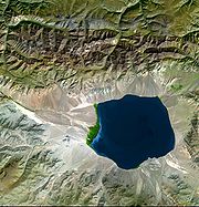
of the west and the north to plains and depressions in the east and the south. The Hüiten Peak in extreme western Mongolia on the Chinese border is the highest point (4,374 metres). The lowest is 518 metres, an otherwise undistinguished spot in the eastern Mongolian plain. The country has an average elevation of 1,580 metres. The landscape includes one of Asia's largest freshwater lakes (Lake Khövsgöl), many salt lakes, marshes, sand dunes, rolling grasslands, alpine forests, and permanent montane glaciers. Northern and western Mongolia are seismically active zones, with frequent earthquakes and many hot springs and extinct volcanoes.
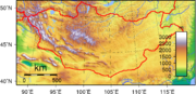
Mongolia has three major mountain ranges. The highest is the Altai Mountains, which stretch across the western and the southwestern regions of the country on a northwest-to-southeast axis. The Khangai Mountains, mountains also trending northwest to southeast, occupy much of central and north-central Mongolia. These are older, lower, and more eroded mountains, with many forests and alpine pastures. The Khentii Mountains
near the Russian border to the northeast of Ulaanbaatar
, are lower still. Much of eastern Mongolia is occupied by a plain, and the lowest area is a southwest-to-northeast trending depression that reaches from the Gobi Desert
region in the south to the eastern frontier. The rivers drain in three directions: north to the Arctic Ocean, east to the Pacific, or into the deserts and the depressions of Inner Asia. Rivers are most extensively developed in the north, and the country's major river system is that of the Selenge
, which drains into Lake Baikal
. Some minor tributaries of Siberia's Yenisei River
also rise in the mountains of northwestern Mongolia. Rivers in northeastern Mongolia drain into the Pacific through the Argun and Amur (Heilong Jiang) rivers, while the few streams of southern and western Mongolia do not reach the sea but run into lakes or deserts.
, some regions of which receive no precipitation at all in most years. The name Gobi is a Mongol word meaning desert, depression, salt marsh, or steppe, but which usually refers to a category of arid rangeland with insufficient vegetation to support marmots but with enough to support camels. Mongols distinguish Gobi from desert proper, although the distinction is not always apparent to outsiders unfamiliar with the Mongolian landscape. Gobi rangelands are fragile and are easily destroyed by overgrazing, which results in expansion of the true desert, a stony waste where not even Bactrian camels can survive.
Average temperatures over most of the country are below freezing from November through March and are about freezing in April and October. January and February averages of -20 °C are common, with winter nights of -40 °C occurring most years. Summer extremes reach as high as 38 °C (100.4 °F) in the southern Gobi region and 33 °C (91.4 °F) in Ulaanbaatar. Most of Mongolia is covered by discontinuous permafrost (grading to continuous at high altitudes), which makes construction, road building, and mining difficult. All rivers and freshwater lakes freeze over in the winter, and smaller streams commonly freeze to the bottom. Ulaanbaatar lies at 1351 metres (4,432 ft) above sea level in the valley of the Tuul River
. Located in the relatively well-watered north, it receives an annual average of 310 millimetres (12.2 in) of precipitation, almost all of which falls in July and in August. Ulaanbaatar has an average annual temperature of -2.9 °C and a frost-free period extending on the average from mid-June to late August.
Mongolia's weather is characterized by extreme variability and short-term unpredictability in the summer, and the multiyear averages conceal wide variations in precipitation, dates of frosts, and occurrences of blizzards and spring dust storms. Such weather poses severe challenges to human and livestock survival. Official statistics list less than 1 % of the country as arable, 8 to 10 % as forest, and the rest as pasture or desert. Grain, mostly wheat, is grown in the valleys of the Selenge river system in the north, but yields fluctuate widely and unpredictably as a result of the amount and the timing of rain and the dates of killing frosts. Although winters are generally cold and clear, there are occasional blizzards that do not deposit much snow but cover the grasses with enough snow and ice to make grazing impossible, killing off tens of thousands of sheep or cattle. Such losses of livestock, which are an inevitable and, in a sense, normal consequence of the climate, have made it difficult for planned increases in livestock numbers to be achieved.
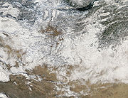 Severe blizzards can occur in the region. The winters of 1970-1971, 2000–2001, 2008–2009 and 2009-2010 were particularly harsh.
The blizzards of December 2000 blocked many roads, and killed 16,000 livestock and 10 people.
. The Mongolian State Emergency Commission said it was the coldest winter in 30 years and, like the preceding harsh summer drought
, could have been the result of global warming
. The U.N. provided major aid due to the high level of damage caused.
In the snowstorms between the 8 and 28 May 2008, 21 people were killed and 100 others went missing in seven provinces in eastern Mongolia. The toll finally reached at least 52 people and 200,000 livestock by the end of June. Most of the victims were herders who froze to death along with their livestock. It was the worst cold snap
since the founding of the modern state in 1922.
Snowstorms in December 2009 also killed 2,000 stock and 5 people.
total:
1.565 million km²
land:
1.565 million km²
water:
0 km²
Area - comparative:
slightly smaller than Alaska
Land boundaries:
total:
8,114 km
border countries:
China 4,673 km, Russia 3,441 km
Coastline:
0 km (landlocked)
Maritime claims:
none (landlocked)
Elevation extremes:
lowest point:
Hoh Nuur 518 m
highest point:
Hüiten Peak 4,374 m
petroleum
, coal
, copper
, molybdenum
, tungsten
, phosphates, tin
, nickel
, zinc
, fluorspar, gold
Land use:
arable land:
1%
permanent crops:
0%
permanent pastures:
80%
forests and woodland:
9%
other:
10% (1993 est.)
Irrigated land:
800 km² (1993 est.)
to southern Patagonia
. See Geography of Chile#Antipodes and Geography of Argentina#Antipodes for details.
Mongolia
Mongolia is a landlocked country in East and Central Asia. It is bordered by Russia to the north and China to the south, east and west. Although Mongolia does not share a border with Kazakhstan, its western-most point is only from Kazakhstan's eastern tip. Ulan Bator, the capital and largest...
is a landlocked country in Northern Asia
Asia
Asia is the world's largest and most populous continent, located primarily in the eastern and northern hemispheres. It covers 8.7% of the Earth's total surface area and with approximately 3.879 billion people, it hosts 60% of the world's current human population...
, strategically located between China
China
Chinese civilization may refer to:* China for more general discussion of the country.* Chinese culture* Greater China, the transnational community of ethnic Chinese.* History of China* Sinosphere, the area historically affected by Chinese culture...
and Russia
Russia
Russia or , officially known as both Russia and the Russian Federation , is a country in northern Eurasia. It is a federal semi-presidential republic, comprising 83 federal subjects...
. The terrain is one of mountains and rolling plateaus, with a high degree of relief. Overall, the land slopes from the high Altay Mountains
Altay Mountains
The Altai Mountains are a mountain range in East-Central Asia, where Russia, China, Mongolia and Kazakhstan come together, and where the rivers Irtysh and Ob have their sources. The Altai Mountains are known as the original locus of the speakers of Turkic as well as other members of the proposed...
of the west and the north to plains and depressions in the east and the south. The Hüiten Peak in extreme western Mongolia on the Chinese border is the highest point (4,374 metres). The lowest is 518 metres, an otherwise undistinguished spot in the eastern Mongolian plain. The country has an average elevation of 1,580 metres. The landscape includes one of Asia's largest freshwater lakes (Lake Khövsgöl), many salt lakes, marshes, sand dunes, rolling grasslands, alpine forests, and permanent montane glaciers. Northern and western Mongolia are seismically active zones, with frequent earthquakes and many hot springs and extinct volcanoes.
Mountain regions
Mongolia has three major mountain ranges. The highest is the Altai Mountains, which stretch across the western and the southwestern regions of the country on a northwest-to-southeast axis. The Khangai Mountains, mountains also trending northwest to southeast, occupy much of central and north-central Mongolia. These are older, lower, and more eroded mountains, with many forests and alpine pastures. The Khentii Mountains
Khentii Mountains
The Khentii Mountains are a mountain range in the Töv and Khentii Provinces in northern Mongolia. The chain overlaps the Khan Khentii Strictly Protected Area and includes Mongolia's sacred mountain, Burkhan Khaldun, which is associated with the origin of Genghis Khan.The range forms the watershed...
near the Russian border to the northeast of Ulaanbaatar
Ulaanbaatar
Ulan Bator or Ulaanbaatar is the capital and largest city of Mongolia. An independent municipality, the city is not part of any province, and its population as of 2008 is over one million....
, are lower still. Much of eastern Mongolia is occupied by a plain, and the lowest area is a southwest-to-northeast trending depression that reaches from the Gobi Desert
Gobi Desert
The Gobi is a large desert region in Asia. It covers parts of northern and northwestern China, and of southern Mongolia. The desert basins of the Gobi are bounded by the Altai Mountains and the grasslands and steppes of Mongolia on the north, by the Hexi Corridor and Tibetan Plateau to the...
region in the south to the eastern frontier. The rivers drain in three directions: north to the Arctic Ocean, east to the Pacific, or into the deserts and the depressions of Inner Asia. Rivers are most extensively developed in the north, and the country's major river system is that of the Selenge
Selenga
The Selenge is a major river in Mongolia and Buryatia, Russia. Its source rivers are the Ider River and the Delgermörön river. It flows into Lake Baikal and has a length of 616 miles...
, which drains into Lake Baikal
Lake Baikal
Lake Baikal is the world's oldest at 30 million years old and deepest lake with an average depth of 744.4 metres.Located in the south of the Russian region of Siberia, between Irkutsk Oblast to the northwest and the Buryat Republic to the southeast, it is the most voluminous freshwater lake in the...
. Some minor tributaries of Siberia's Yenisei River
Yenisei River
Yenisei , also written as Yenisey, is the largest river system flowing to the Arctic Ocean. It is the central of the three great Siberian rivers that flow into the Arctic Ocean...
also rise in the mountains of northwestern Mongolia. Rivers in northeastern Mongolia drain into the Pacific through the Argun and Amur (Heilong Jiang) rivers, while the few streams of southern and western Mongolia do not reach the sea but run into lakes or deserts.
Overview
Mongolia is high, cold, and dry. It has an extreme continental climate with long, cold winters and short summers, during which most precipitation falls. The country averages 257 cloudless days a year, and it is usually at the centre of a region of high atmospheric pressure. Precipitation is highest in the north, which averages 200 to 350 mm (7.9 to 13.8 in) per year, and lowest in the south, which receives 100 to 200 mm (3.9 to 7.9 in). The extreme south is the Gobi DesertGobi Desert
The Gobi is a large desert region in Asia. It covers parts of northern and northwestern China, and of southern Mongolia. The desert basins of the Gobi are bounded by the Altai Mountains and the grasslands and steppes of Mongolia on the north, by the Hexi Corridor and Tibetan Plateau to the...
, some regions of which receive no precipitation at all in most years. The name Gobi is a Mongol word meaning desert, depression, salt marsh, or steppe, but which usually refers to a category of arid rangeland with insufficient vegetation to support marmots but with enough to support camels. Mongols distinguish Gobi from desert proper, although the distinction is not always apparent to outsiders unfamiliar with the Mongolian landscape. Gobi rangelands are fragile and are easily destroyed by overgrazing, which results in expansion of the true desert, a stony waste where not even Bactrian camels can survive.
Average temperatures over most of the country are below freezing from November through March and are about freezing in April and October. January and February averages of -20 °C are common, with winter nights of -40 °C occurring most years. Summer extremes reach as high as 38 °C (100.4 °F) in the southern Gobi region and 33 °C (91.4 °F) in Ulaanbaatar. Most of Mongolia is covered by discontinuous permafrost (grading to continuous at high altitudes), which makes construction, road building, and mining difficult. All rivers and freshwater lakes freeze over in the winter, and smaller streams commonly freeze to the bottom. Ulaanbaatar lies at 1351 metres (4,432 ft) above sea level in the valley of the Tuul River
Tuul River
Tuul River is a river in central and northern Mongolia considered sacred by the Mongols. It is 704 km long and drains an area 49,840 square km. The river is called the "Duluo river" in the Suishu, a Chinese historical work completed in 636 AD...
. Located in the relatively well-watered north, it receives an annual average of 310 millimetres (12.2 in) of precipitation, almost all of which falls in July and in August. Ulaanbaatar has an average annual temperature of -2.9 °C and a frost-free period extending on the average from mid-June to late August.
Mongolia's weather is characterized by extreme variability and short-term unpredictability in the summer, and the multiyear averages conceal wide variations in precipitation, dates of frosts, and occurrences of blizzards and spring dust storms. Such weather poses severe challenges to human and livestock survival. Official statistics list less than 1 % of the country as arable, 8 to 10 % as forest, and the rest as pasture or desert. Grain, mostly wheat, is grown in the valleys of the Selenge river system in the north, but yields fluctuate widely and unpredictably as a result of the amount and the timing of rain and the dates of killing frosts. Although winters are generally cold and clear, there are occasional blizzards that do not deposit much snow but cover the grasses with enough snow and ice to make grazing impossible, killing off tens of thousands of sheep or cattle. Such losses of livestock, which are an inevitable and, in a sense, normal consequence of the climate, have made it difficult for planned increases in livestock numbers to be achieved.
Seasonal blizzards
The blizzards of December 2000 blocked many roads, and killed 16,000 livestock and 10 people.
. The Mongolian State Emergency Commission said it was the coldest winter in 30 years and, like the preceding harsh summer drought
Drought
A drought is an extended period of months or years when a region notes a deficiency in its water supply. Generally, this occurs when a region receives consistently below average precipitation. It can have a substantial impact on the ecosystem and agriculture of the affected region...
, could have been the result of global warming
Global warming
Global warming refers to the rising average temperature of Earth's atmosphere and oceans and its projected continuation. In the last 100 years, Earth's average surface temperature increased by about with about two thirds of the increase occurring over just the last three decades...
. The U.N. provided major aid due to the high level of damage caused.
In the snowstorms between the 8 and 28 May 2008, 21 people were killed and 100 others went missing in seven provinces in eastern Mongolia. The toll finally reached at least 52 people and 200,000 livestock by the end of June. Most of the victims were herders who froze to death along with their livestock. It was the worst cold snap
Cold wave
A cold wave is a weather phenomenon that is distinguished by a cooling of the air. Specifically, as used by the U.S. National Weather Service, a cold wave is a rapid fall in temperature within a 24 hour period requiring substantially increased protection to agriculture, industry, commerce, and...
since the founding of the modern state in 1922.
Snowstorms in December 2009 also killed 2,000 stock and 5 people.
Ecoregions
- Altai montane forest and forest steppe
- Khangai Mountains conifer forests
- Selenge-Orkhon forest steppe
- Sayan montane conifer forests
- Trans-Baikal conifer forests
- Daurian forest steppe
- Mongolian-Manchurian grasslandMongolian-Manchurian grasslandThe Mongolian-Manchurian grassland ecoregion, also known as the Mongolian-Manchurian steppe, in the temperate grassland Biome, is found in Mongolia, the Chinese Autonomous region of Inner Mongolia and northeastern China.-Setting:...
- Altai alpine meadow and tundra
- Khangai Mountains alpine meadow
- Sayan Alpine meadows and tundra
- Alashan Plateau semi-desert
- Eastern Gobi desert steppe
- Gobi desertGobi DesertThe Gobi is a large desert region in Asia. It covers parts of northern and northwestern China, and of southern Mongolia. The desert basins of the Gobi are bounded by the Altai Mountains and the grasslands and steppes of Mongolia on the north, by the Hexi Corridor and Tibetan Plateau to the...
- Gobi Lakes Valley desert steppe
- Great Lakes Basin desert steppe
- Junggar Basin semi-desert
Area and boundaries
Area:total:
1.565 million km²
land:
1.565 million km²
water:
0 km²
Area - comparative:
slightly smaller than Alaska
Alaska
Alaska is the largest state in the United States by area. It is situated in the northwest extremity of the North American continent, with Canada to the east, the Arctic Ocean to the north, and the Pacific Ocean to the west and south, with Russia further west across the Bering Strait...
Land boundaries:
total:
8,114 km
border countries:
China 4,673 km, Russia 3,441 km
Coastline:
0 km (landlocked)
Maritime claims:
none (landlocked)
Elevation extremes:
lowest point:
Hoh Nuur 518 m
highest point:
Hüiten Peak 4,374 m
Resources and land use
Natural resources:petroleum
Petroleum
Petroleum or crude oil is a naturally occurring, flammable liquid consisting of a complex mixture of hydrocarbons of various molecular weights and other liquid organic compounds, that are found in geologic formations beneath the Earth's surface. Petroleum is recovered mostly through oil drilling...
, coal
Coal
Coal is a combustible black or brownish-black sedimentary rock usually occurring in rock strata in layers or veins called coal beds or coal seams. The harder forms, such as anthracite coal, can be regarded as metamorphic rock because of later exposure to elevated temperature and pressure...
, copper
Copper
Copper is a chemical element with the symbol Cu and atomic number 29. It is a ductile metal with very high thermal and electrical conductivity. Pure copper is soft and malleable; an exposed surface has a reddish-orange tarnish...
, molybdenum
Molybdenum
Molybdenum , is a Group 6 chemical element with the symbol Mo and atomic number 42. The name is from Neo-Latin Molybdaenum, from Ancient Greek , meaning lead, itself proposed as a loanword from Anatolian Luvian and Lydian languages, since its ores were confused with lead ores...
, tungsten
Tungsten
Tungsten , also known as wolfram , is a chemical element with the chemical symbol W and atomic number 74.A hard, rare metal under standard conditions when uncombined, tungsten is found naturally on Earth only in chemical compounds. It was identified as a new element in 1781, and first isolated as...
, phosphates, tin
Tin
Tin is a chemical element with the symbol Sn and atomic number 50. It is a main group metal in group 14 of the periodic table. Tin shows chemical similarity to both neighboring group 14 elements, germanium and lead and has two possible oxidation states, +2 and the slightly more stable +4...
, nickel
Nickel
Nickel is a chemical element with the chemical symbol Ni and atomic number 28. It is a silvery-white lustrous metal with a slight golden tinge. Nickel belongs to the transition metals and is hard and ductile...
, zinc
Zinc
Zinc , or spelter , is a metallic chemical element; it has the symbol Zn and atomic number 30. It is the first element in group 12 of the periodic table. Zinc is, in some respects, chemically similar to magnesium, because its ion is of similar size and its only common oxidation state is +2...
, fluorspar, gold
Gold
Gold is a chemical element with the symbol Au and an atomic number of 79. Gold is a dense, soft, shiny, malleable and ductile metal. Pure gold has a bright yellow color and luster traditionally considered attractive, which it maintains without oxidizing in air or water. Chemically, gold is a...
Land use:
arable land:
1%
permanent crops:
0%
permanent pastures:
80%
forests and woodland:
9%
other:
10% (1993 est.)
Irrigated land:
800 km² (1993 est.)
Antipodes
Much of central and western Mongolia, including Ulaanbaatar, is antipodalAntipodes
In geography, the antipodes of any place on Earth is the point on the Earth's surface which is diametrically opposite to it. Two points that are antipodal to one another are connected by a straight line running through the centre of the Earth....
to southern Patagonia
Patagonia
Patagonia is a region located in Argentina and Chile, integrating the southernmost section of the Andes mountains to the southwest towards the Pacific ocean and from the east of the cordillera to the valleys it follows south through Colorado River towards Carmen de Patagones in the Atlantic Ocean...
. See Geography of Chile#Antipodes and Geography of Argentina#Antipodes for details.