

Geography of Moldova
Encyclopedia
Europe
Europe is, by convention, one of the world's seven continents. Comprising the westernmost peninsula of Eurasia, Europe is generally 'divided' from Asia to its east by the watershed divides of the Ural and Caucasus Mountains, the Ural River, the Caspian and Black Seas, and the waterways connecting...
, Moldova
Moldova
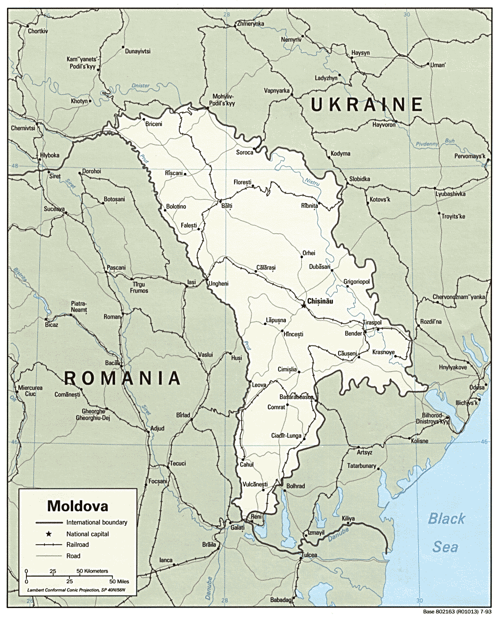
Moldova , officially the Republic of Moldova is a landlocked state in Eastern Europe, located between Romania to the West and Ukraine to the North, East and South. It declared itself an independent state with the same boundaries as the preceding Moldavian Soviet Socialist Republic in 1991, as part...
is bordered on the west by Romania
Romania
Romania is a country located at the crossroads of Central and Southeastern Europe, on the Lower Danube, within and outside the Carpathian arch, bordering on the Black Sea...
and on the north, south, and east by Ukraine
Ukraine
Ukraine is a country in Eastern Europe. It has an area of 603,628 km², making it the second largest contiguous country on the European continent, after Russia...
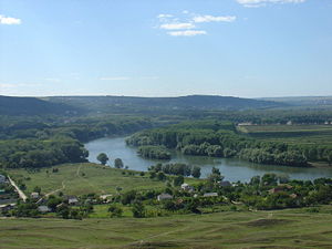
. Most of its territory lies between the area's two main rivers, the Dniester
Dniester
The Dniester is a river in Eastern Europe. It runs through Ukraine and Moldova and separates most of Moldova's territory from the breakaway de facto state of Transnistria.-Names:...
and the Prut
Prut
The Prut is a long river in Eastern Europe. In part of its course it forms the border between Romania and Moldova.-Overview:...
. The Dniester forms a small part of Moldova's border with Ukraine in the northeast and southeast, but it mainly flows through the eastern part of the country, separating Bessarabia
Bessarabia
Bessarabia is a historical term for the geographic region in Eastern Europe bounded by the Dniester River on the east and the Prut River on the west....
and Transnistria
Transnistria
Transnistria is a breakaway territory located mostly on a strip of land between the Dniester River and the eastern Moldovan border to Ukraine...
. The Prut River forms Moldova's entire western boundary with Romania. The Danube
Danube
The Danube is a river in the Central Europe and the Europe's second longest river after the Volga. It is classified as an international waterway....
touches the Moldovan border at its southernmost tip, and forms the border for 200 m (656 ft).
Phytogeographically
Phytogeography
Phytogeography , also called geobotany, is the branch of biogeography that is concerned with the geographic distribution of plant species...
, Moldova is shared between the Central European and Eastern European provinces of the Circumboreal Region
Circumboreal Region
The Circumboreal Region is a floristic region within the Holarctic Kingdom in Eurasia and North America, as delineated by such geobotanists as Josias Braun-Blanquet and Armen Takhtajan....
within the Boreal Kingdom
Boreal Kingdom
The Boreal Kingdom or Holarctic Kingdom is a floristic kingdom identified by botanist Ronald Good , which includes the temperate to Arctic portions of North America and Eurasia. Its flora is inherited from the ancient supercontinent of Laurasia...
. According to the WWF
World Wide Fund for Nature
The World Wide Fund for Nature is an international non-governmental organization working on issues regarding the conservation, research and restoration of the environment, formerly named the World Wildlife Fund, which remains its official name in Canada and the United States...
, the territory of Moldova can be subdivided into three ecoregion
Ecoregion
An ecoregion , sometimes called a bioregion, is an ecologically and geographically defined area that is smaller than an ecozone and larger than an ecosystem. Ecoregions cover relatively large areas of land or water, and contain characteristic, geographically distinct assemblages of natural...
s: the Central European mixed forests, the East European forest steppe (the most territory of the country), and Pontic steppe (in the south and southeast).
Basic data
Location:Eastern Europe
Eastern Europe
Eastern Europe is the eastern part of Europe. The term has widely disparate geopolitical, geographical, cultural and socioeconomic readings, which makes it highly context-dependent and even volatile, and there are "almost as many definitions of Eastern Europe as there are scholars of the region"...
, northeast of Romania
Geographic coordinates:
47°00′N 29°00′E
Map references:
Commonwealth of Independent States
Area:
total:
33,843 km²
land:
33,371 km²
water:
472 km²
Area - comparative:
slightly larger than Maryland
Maryland
Maryland is a U.S. state located in the Mid Atlantic region of the United States, bordering Virginia, West Virginia, and the District of Columbia to its south and west; Pennsylvania to its north; and Delaware to its east...
, United States
United States
The United States of America is a federal constitutional republic comprising fifty states and a federal district...
Land boundaries:
total:
1,389 km
border countries:
Romania 450 km, Ukraine 939 km
Coastline:
0 km (landlocked)
Maritime claims:
none (landlocked)
Natural resources:
lignite, phosphorites, gypsum, arable land
Land use:
arable land:
53%
permanent crops:
14%
permanent pastures:
13%
forests and woodland:
13%
other:
7% (1993 est.)
Irrigated land:
3,110 km² (1993 est.)
Natural hazards:
landslides (57 cases in 1998)
Extreme points
- The lowest point: Nistru river −2 m
- The highest point – Bălăneşti Hill +430 m
- North extreme: NaslavceaNaslavceaNaslavcea is a commune in Ocniţa district and the northernmost point in Moldova. It is composed of a single village, Naslavcea....
- South extreme: GiurgiuleştiGiurgiulestiGiurgiuleşti is a commune in the Cahul district of Moldova. It is also a border crossing point to Romania, located from Galaţi.- Geography :...
- West extreme: CrivaCriva, BriceniCriva is a commune in Briceni district, Moldova. It is composed of a single village, Criva.It is the westernmost point in Moldova and a border crossing point to Ukraine....
- East extreme: Palanca
Climate
Moldova's proximity to the Black SeaBlack Sea
The Black Sea is bounded by Europe, Anatolia and the Caucasus and is ultimately connected to the Atlantic Ocean via the Mediterranean and the Aegean seas and various straits. The Bosphorus strait connects it to the Sea of Marmara, and the strait of the Dardanelles connects that sea to the Aegean...
gives it a mild and sunny climate.
Moldova's climate is moderately continental: the summers are warm and long, with temperatures averaging about 20 °C (68 °F), and the winters are relatively mild and dry, with January temperatures averaging −4 °C. Annual rainfall, which ranges from around 600 millimetres (23.6 in) in the north to 400 millimetres (15.7 in) in the south, can vary greatly; long dry spells are not unusual. The heaviest rainfall occurs in early summer and again in October; heavy showers and thunderstorms are common. Because of the irregular terrain, heavy summer rains often cause erosion and river silting.
Weather records.
The highest temperature ever recorded: 41.5 °C (106.7 °F) on July 21, 2007 (Camenca).
The lowest temperature ever recorded: −35.5 °C on January 20, 1963 (Brătuşeni, Edineţ county).
Chişinău's climate. (Central Moldova)
Bălţi's climate. (Northern Moldova)
Tiraspol's climate. (Central Moldova)
Cahul's climate. (Southern Moldova)
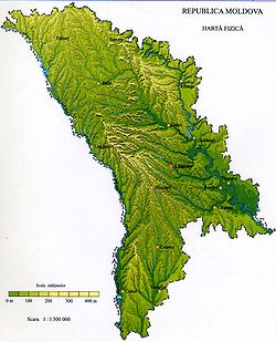
Topography
Moldavian Plateau
The Moldavian Plateau is a geographic area spanning northeast Romania, most of Moldova , and most of the Chernivtsi Oblast of Ukraine.-Limits:The Moldavian Plateau is bounded :...
, which geologically originate from the Carpathian Mountains
Carpathian Mountains
The Carpathian Mountains or Carpathians are a range of mountains forming an arc roughly long across Central and Eastern Europe, making them the second-longest mountain range in Europe...
.
The northern landscape of Moldova is characterized by gently rolling uplands of the Dniester Hills
Dniester Hills
Dniester Hills , also known as Northern Moldavian Plateau is a geographic area that comprises most of the northern Moldova, and parts of the Chernivtsi Oblast of Ukraine...
(up to 300 m or 984 ft, in elevation
Elevation
The elevation of a geographic location is its height above a fixed reference point, most commonly a reference geoid, a mathematical model of the Earth's sea level as an equipotential gravitational surface ....
) interlaced with small flat plains in the valleys of the numerous creeks
Stream
A stream is a body of water with a current, confined within a bed and stream banks. Depending on its locale or certain characteristics, a stream may be referred to as a branch, brook, beck, burn, creek, "crick", gill , kill, lick, rill, river, syke, bayou, rivulet, streamage, wash, run or...
(at 150 m or 492 ft elevation). These hills, which have an average altitude of 240 metres (787 ft) and a maximum altitude of 320 metres (1,050 ft), can be divided into the Northern Moldavian Hills and the Dniester Ridge, and continue further occupying the northern part of the Chernivtsi oblast
Chernivtsi Oblast
Chernivtsi Oblast is an oblast in western Ukraine, bordering on Romania and Moldova. It has a large variety of landforms: the Carpathian Mountains and picturesque hills at the foot of the mountains gradually change to a broad partly forested plain situated between the Dniester and Prut rivers....
in Ukraine
Ukraine
Ukraine is a country in Eastern Europe. It has an area of 603,628 km², making it the second largest contiguous country on the European continent, after Russia...
. The eastern slopes of the Dniester Ridge (average 250 metres (820 ft), max 347 metres (1,138 ft)), form the high right bank of the Dniester River.
Balti Steppe
Bălţi Steppe , also Beltsy Steppe is a hilly area with few trees , dominated by agriculturally cultivated land, and occasionally by grasses and shrubs, in the northern part of Moldova...
and the Middle Prut Valley. Originally forest
Forest
A forest, also referred to as a wood or the woods, is an area with a high density of trees. As with cities, depending where you are in the world, what is considered a forest may vary significantly in size and have various classification according to how and what of the forest is composed...
ed, it has been extensively de-forested for agriculture
Agriculture
Agriculture is the cultivation of animals, plants, fungi and other life forms for food, fiber, and other products used to sustain life. Agriculture was the key implement in the rise of sedentary human civilization, whereby farming of domesticated species created food surpluses that nurtured the...
during the 19th and 20th centuries. In contrast to the region to the north and south, which is smore slant, this area is referred to as plain, although it has relief
Terrain
Terrain, or land relief, is the vertical and horizontal dimension of land surface. When relief is described underwater, the term bathymetry is used...
very different from that of a flatland, and vegetation different from that of the steppe
Steppe
In physical geography, steppe is an ecoregion, in the montane grasslands and shrublands and temperate grasslands, savannas, and shrublands biomes, characterized by grassland plains without trees apart from those near rivers and lakes...
.
Central Moldavian Plateau
The Central Moldavian Plateau , or Codru Massif is a geographic area in Moldova. It is the central and SE part of the Moldavian Plateau. It has elevations that in the N-S direction decrease in altitude from 400 m to under 200 m....
, at an average elevation of about 350 to 400 m (1,148.3 to 1,312.3 ft), are ridges interlaced by deep, flat valleys, ravines, and landslide-scoured depressions. Steep forest-clad slopes account for much of the terrain, where the most common trees are hornbeam, oak, linden, maple, wild pear, and wild cherry. The term Codri refers more generally to all the forests between the Carpathians and the Dniester
Dniester
The Dniester is a river in Eastern Europe. It runs through Ukraine and Moldova and separates most of Moldova's territory from the breakaway de facto state of Transnistria.-Names:...
river, and even more generally to all forests in the area of the Carpathians, yet since in Moldova most of them were preserved in the central part, Codri sometimes can colloquially refer to the remaining forests in the hills west and north of Chişinău
Chisinau
Chișinău is the capital and largest municipality of Moldova. It is also its main industrial and commercial centre and is located in the middle of the country, on the river Bîc...
. The Dniester Ridge border Central Moldavian Plateau to the north along the river Răut
Raut
Răut, also referred to as Reut is a river in Moldova, a right tributary of Dniester. Răut, generally navigable until 18-19th century, is navigable today only by small recreational boats.The towns Bălţi, Orhei and Floreşti are located by the river....
.
The plateau can be divided into 5 parts: Ciuluc-Soloneţ Hills , alongated in the north along the right side of the Răut river, 1690 square kilometre, Corneşti Hills , also known as Cordi Hills , 4740 square kilometre, Lower Dniester Hills , alongated to the south of the Botna river, 3040 square kilometre, Tigheci Hills , alongated in the south along the left side of the Prut river, 3550 square kilometre, and between the latter and the Prut river, the Lower Prut Valley , 1810 square kilometre.
The country's highest point, Bălăneşti Hill, which reaches 1407 or, depending on the source, is situated in the Corneşti Hills, the western part of the Central Moldavian Plateau. Northwest of it are the Ciuluc-Soloneţ Hills (average 250 metres (820 ft), max 388 metres (1,273 ft)). In the south, the Tigheci Hills
Tigheci
Tigheci is a commune in Leova district, Moldova. It is composed of two villages, Tigheci and Cuporani....
(average 200 metres (656 ft), max 301 metres (988 ft)) are a prolongation, and run to the south parallel to the Lower Prut Valley.
To the south-east, the southern part of the Central Moldavian Plateau, which averages 150–200 m (492.1–656.2 ft), max 250 metres (820 ft), and has numerous ravines and gullies, gradually vanishs into the extensive Bugeac Plain, with most of the Budjak
Budjak
Budjak or Budzhak is a historical region in the Odessa Oblast of Ukraine. Lying along the Black Sea between the Danube and Dniester rivers this multiethnic region was the southern part of Bessarabia...
region already in Ukraine.
Transnistria
Transnistria
Transnistria is a breakaway territory located mostly on a strip of land between the Dniester River and the eastern Moldovan border to Ukraine...
(the left bank of the Dniester) has spurs of the Podolian Plateau , (average 180 metres (591 ft), max 275 metres (902 ft)), which are cut into by tributaries of the Dniester River. The southern half of Transnistria, the Lower Dniester Plain, can be regarded as the western end of the Eurasian steppe
Eurasian Steppe
The Eurasian Steppe is the vast steppe ecoregion of Eurasia in the Temperate grasslands, savannas, and shrublands Biome. It stretches from Hungary to Mongolia...
, and has an average elevation of 100 metres (328 ft), with a maximum of 170 metres (558 ft). The high right bank and low left bank of the Dniester are in sharp contrast here, where visibility is not impeded by forests.
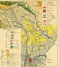
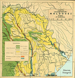
About 75 percent of Moldova is covered by a soil type called black earth
Black earth
Black earth, Black land or Dark earth may refer to:-Locations:* Black Earth, Wisconsin, a village* Black Earth , Wisconsin* Central Black Earth Region, of Central Russia-Soil science:...
or chernozem
Chernozem
Chernozem , also known as "black land" or "black earth", is a black-coloured soil containing a high percentage of humus 7% to 15%, and high percentages of phosphoric acids, phosphorus and ammonia...
. In the northern hills, more clay textured soils are found; in the south, red-earth soil is predominant. The soil becomes less fertile toward the south but can still support grape and sunflower production. The hills have woodland soils, while a small portion in southern Moldova is in the steppe
Steppe
In physical geography, steppe is an ecoregion, in the montane grasslands and shrublands and temperate grasslands, savannas, and shrublands biomes, characterized by grassland plains without trees apart from those near rivers and lakes...
zone, although most steppe areas today are cultivated. The lower reaches of the Prut and Dniester rivers and the southern river valleys are saline marshes.
Drainage in Moldova is to the south, toward the Black Sea
Black Sea
The Black Sea is bounded by Europe, Anatolia and the Caucasus and is ultimately connected to the Atlantic Ocean via the Mediterranean and the Aegean seas and various straits. The Bosphorus strait connects it to the Sea of Marmara, and the strait of the Dardanelles connects that sea to the Aegean...
lowlands, and eventually into the Black Sea, but only eight rivers and creeks extend more than 100 kilometers. Moldova's main river, the Dniester
Dniester
The Dniester is a river in Eastern Europe. It runs through Ukraine and Moldova and separates most of Moldova's territory from the breakaway de facto state of Transnistria.-Names:...
, is navigable throughout almost the entire country, and in warmer winters it does not freeze over. The Prut
Prut
The Prut is a long river in Eastern Europe. In part of its course it forms the border between Romania and Moldova.-Overview:...
river is a tributary of the Danube
Danube
The Danube is a river in the Central Europe and the Europe's second longest river after the Volga. It is classified as an international waterway....
, which it joins at the far southwestern tip of the country. Over 95% of the water circulation in Moldova flows into one of the two rivers - the Prut or Dniester. Of Moldova's well-developed network of about 3,000 creeks and streams, all draining south to the Black Sea, only 246 exceed 6 mi (9.7 km) in length, and only 8 exceed 60 mi (96.6 km).
Underground water, extensively used for the country's water supply, includes about 2,200 natural springs. The terrain favours construction of reservoirs of various size.
Elevation extremes:
lowest point:
an unnamed point on the bank of the Dniester River 2 m (6.56 ft)
highest point:
Dealul Bălăneşti 430 m (1,411 ft)
Natural habitat
Moldova's natural habitat is characterized by forest steppeForest steppe
A forest steppe is a temperate-climate ecotone and habitat type composed of grassland interspersed with areas of woodland or forest.-Locations:...
s, a temperate-climate habitat type composed of grassland
Grassland
Grasslands are areas where the vegetation is dominated by grasses and other herbaceous plants . However, sedge and rush families can also be found. Grasslands occur naturally on all continents except Antarctica...
interspersed with areas of woodland
Woodland
Ecologically, a woodland is a low-density forest forming open habitats with plenty of sunlight and limited shade. Woodlands may support an understory of shrubs and herbaceous plants including grasses. Woodland may form a transition to shrubland under drier conditions or during early stages of...
or forest
Forest
A forest, also referred to as a wood or the woods, is an area with a high density of trees. As with cities, depending where you are in the world, what is considered a forest may vary significantly in size and have various classification according to how and what of the forest is composed...
. A belt of forest steppes cross Eurasia
Eurasia
Eurasia is a continent or supercontinent comprising the traditional continents of Europe and Asia ; covering about 52,990,000 km2 or about 10.6% of the Earth's surface located primarily in the eastern and northern hemispheres...
from eastern Europe to Eastern Siberia, forming a transition between temperate broadleaf and mixed forests
Temperate broadleaf and mixed forests
Mixed forests are a temperate and humid biome. The typical structure of these forests includes four layers. The uppermost layer is the canopy composed of tall mature trees ranging from 33 to 66 m high. Below the canopy is the three-layered, shade-tolerant understory that is roughly 9 to...
and temperate grasslands. In the 19th century Moldova witnessed a sharp decrease in the forested areas, sacrificed for agriculture due to rich soil.
| land formation | area, km² | of which currently forests, km² | % forests | habitat type |
|---|---|---|---|---|
| Northern Moldavian Hills | 4,630 | 476 | 10.3% | forest steppe Forest steppe A forest steppe is a temperate-climate ecotone and habitat type composed of grassland interspersed with areas of woodland or forest.-Locations:... |
| Dniester-Rāut Ridge | 2,480 | 363 | 14.6% | forest steppe |
| Middle Prut Valley | 2,930 | 312 | 10.6% | forest steppe |
| Bălţi Steppe Balti Steppe Bălţi Steppe , also Beltsy Steppe is a hilly area with few trees , dominated by agriculturally cultivated land, and occasionally by grasses and shrubs, in the northern part of Moldova... |
1,920 | 51 | 2.7% | steppe Steppe In physical geography, steppe is an ecoregion, in the montane grasslands and shrublands and temperate grasslands, savannas, and shrublands biomes, characterized by grassland plains without trees apart from those near rivers and lakes... |
| Ciuluc-Soloneţ Hills | 1,690 | 169 | 10.0% | forest steppe |
| Corneşti Hills (Codru) | 4,740 | 1,300 | 27.5% | forest Forest A forest, also referred to as a wood or the woods, is an area with a high density of trees. As with cities, depending where you are in the world, what is considered a forest may vary significantly in size and have various classification according to how and what of the forest is composed... |
| Lower Dniester Hills | 3,040 | 371 | 12.2% | forest steppe |
| Lower Prut Valley | 1,810 | 144 | 8.0% | forest steppe |
| Tigheci Hills | 3,550 | 533 | 15.0% | forest steppe |
| Bugeac Plain | 3,210 | 195 | 6.1% | steppe |
| part of Podolian Plateau | 1,920 | 175 | 9.1% | forest steppe |
| part of Eurasian Steppe Eurasian Steppe The Eurasian Steppe is the vast steppe ecoregion of Eurasia in the Temperate grasslands, savannas, and shrublands Biome. It stretches from Hungary to Mongolia... |
1,920 | 140 | 7.3% | steppe |
| Total | 33,840 | 4,228 | 12,5% | forest steppe |
Environment
Historical references
- In the 5th century BC, HerodotusHerodotusHerodotus was an ancient Greek historian who was born in Halicarnassus, Caria and lived in the 5th century BC . He has been called the "Father of History", and was the first historian known to collect his materials systematically, test their accuracy to a certain extent and arrange them in a...
visited the countryside between the rivers Dnister and PrutPrutThe Prut is a long river in Eastern Europe. In part of its course it forms the border between Romania and Moldova.-Overview:...
and described the place as "a plain with deep black earth, reach in grass and well irrigated".
- Lithuanian Prince JogailaJogailaJogaila, later 'He is known under a number of names: ; ; . See also: Jogaila : names and titles. was Grand Duke of Lithuania , king consort of Kingdom of Poland , and sole King of Poland . He ruled in Lithuania from 1377, at first with his uncle Kęstutis...
spoke of MoldaviaMoldaviaMoldavia is a geographic and historical region and former principality in Eastern Europe, corresponding to the territory between the Eastern Carpathians and the Dniester river...
as "a rich and fructiferous country".
- According to the testimony of Venetian Mateus de Murano, "the country was very well located, reach with cattle and all kinds of fruits, pastures are perfect".
- Rich natural resources of Moldavia always attracted nomads. Fleeing their devastating incursions, inhabitants of Moldavia left the brooded places and hid in forests. French knight Guilbert de Lannoy, who visited these places in 1421, has mentioned insignificant population of the region: "we moved through large deserts".
- Counsellor of Hungarian King George Reihersdorf (middle of 16th century) was complaining of travel through "empty, uninhabited lands". In 1541, he produced the first geographical map (preserved to this day) of the Principality of Moldavia, with rivers Dnister and PrutPrutThe Prut is a long river in Eastern Europe. In part of its course it forms the border between Romania and Moldova.-Overview:...
shown, as well as cities and other localities, but also highlighted large steppes.
- A map of Moldavia was drawn by the German diplomat Sigismund von HerbersteinSigismund von HerbersteinSiegmund Freiherr von Herberstein, , was an Carniolan diplomat, writer, historian and member of the Holy Roman Empire Imperial Council...
. On his map one can see woodless spaces - Bălţi steppeBalti SteppeBălţi Steppe , also Beltsy Steppe is a hilly area with few trees , dominated by agriculturally cultivated land, and occasionally by grasses and shrubs, in the northern part of Moldova...
in the north, and Bugeac SteppeBugeac steppeThe Bugeac steppe is located in the south of Moldova from the Dnister to Prut rivers reaching down to the Black Sea. It’s the biggest steppe in Moldova and site of the foundation of most of the country’s ethnic minority colonies....
in the south.
- In the 17th century, pilgrims Pavel Aleppskii (a Syrian deacon) and Ioan Lukianov (a Russian preast) traveled on their way to the Holy landHoly LandThe Holy Land is a term which in Judaism refers to the Kingdom of Israel as defined in the Tanakh. For Jews, the Land's identifiction of being Holy is defined in Judaism by its differentiation from other lands by virtue of the practice of Judaism often possible only in the Land of Israel...
through Moldavia. These two travellers were striken by the disastrous state of the land that used to blossom: "It better be not ravaged, as no other such can be found, it may yield any kind".
- English traveller John BellJohn Bell (traveller)John Bell, Scottish doctor and traveller, was born at Antermony, near Milton of Campsie in Scotland in 1691. He studied medicine in Glasgow and in 1714 set out for St Petersburg, where, through the introduction of a fellow Scot, he was nominated medical attendant to Artemy Petrovich Volynsky,...
, who also visited Moldavia, and wrote about fecund soils and "small nice towns" situated next to RăutRautRăut, also referred to as Reut is a river in Moldova, a right tributary of Dniester. Răut, generally navigable until 18-19th century, is navigable today only by small recreational boats.The towns Bălţi, Orhei and Floreşti are located by the river....
.
- Russian geographer K. Laksman described Bălţi steppe in the beginning of the 19th century: "To the north is located a steppe with almost no trees at all. To the north-west the steppe is not as woodless".
- Scientist K. Arseniev mentioned that the north of BessarabiaBessarabiaBessarabia is a historical term for the geographic region in Eastern Europe bounded by the Dniester River on the east and the Prut River on the west....
is "a genuine mix of arid steppes with most fertile pastures, rich meadows and gardens".
- Travellers and scholars were amazed by the contrast between rich natural resources of Moldavia/Bălţi steppe and its low population in war torned 18th century, pitiful state of agriculture, as well as the poverty of the local population.
- "Desert, waste, naked steppe... The settling among limitless expanses of Bălţi steppe happened not "in accordnace" with logic, but "against" it. The life of remote ancestors of Bălţiers was full of difficulties and crosses, but they managed to resist."
- "Moldavian fields, as described by both ancient and contemporary writers, are great in their fertility, by far surpassing the richess of the mountains" (Dimitrie CantemirDimitrie CantemirDimitrie Cantemir was twice Prince of Moldavia . He was also a prolific man of letters – philosopher, historian, composer, musicologist, linguist, ethnographer, and geographer....
, "Descriptio Moldaviae"
- "Will someone describe Bessarabian steppes, indeed, they do merit a description. However for this, one needs the talent of unforgettable Gogol, who has so beautifully depicted us the steppes of his homeland. And Bessarabian steppes are not less beautiful." (Constantin Stamati-CiureaConstantin Stamati-CiureaConstantin Stamati-Ciurea was a Romanian writer and translator from Bessarabia. The son of Constantin Stamati, he followed in his father's footsteps as an author of prose, plays, and translations...
)
Current issues
Moldova's communist-era environmental legacy, like that of many other former Soviet republics, is one of environmental degradation. AgriculturalAgriculture
Agriculture is the cultivation of animals, plants, fungi and other life forms for food, fiber, and other products used to sustain life. Agriculture was the key implement in the rise of sedentary human civilization, whereby farming of domesticated species created food surpluses that nurtured the...
practices such as overuse of pesticide
Pesticide
Pesticides are substances or mixture of substances intended for preventing, destroying, repelling or mitigating any pest.A pesticide may be a chemical unicycle, biological agent , antimicrobial, disinfectant or device used against any pest...
s and artificial fertilizers were intended to increase agricultural output at all costs, without regard for the consequences. As a result, Moldova's soil and groundwater were contaminated by lingering chemicals, some of which (including DDT
DDT
DDT is one of the most well-known synthetic insecticides. It is a chemical with a long, unique, and controversial history....
) have been banned in the West.
Such practices continue in Moldova to the present day. In the early 1990s, use of pesticides in Moldova averaged approximately twenty times that of other former Soviet republics and Western nations. In addition, poor farming methods, such as destroying forests to plant vineyards, have contributed to the extensive soil erosion to which the country's rugged topography is already prone.
International environmental agreements
party to:Air Pollution
Air pollution
Air pollution is the introduction of chemicals, particulate matter, or biological materials that cause harm or discomfort to humans or other living organisms, or cause damage to the natural environment or built environment, into the atmosphere....
, Biodiversity
Biodiversity
Biodiversity is the degree of variation of life forms within a given ecosystem, biome, or an entire planet. Biodiversity is a measure of the health of ecosystems. Biodiversity is in part a function of climate. In terrestrial habitats, tropical regions are typically rich whereas polar regions...
, Climate Change
United Nations Framework Convention on Climate Change
The United Nations Framework Convention on Climate Change is an international environmental treaty produced at the United Nations Conference on Environment and Development , informally known as the Earth Summit, held in Rio de Janeiro from June 3 to 14, 1992...
, Desertification
Desertification
Desertification is the degradation of land in drylands. Caused by a variety of factors, such as climate change and human activities, desertification is one of the most significant global environmental problems.-Definitions:...
, Hazardous Wastes, Ozone Layer Protection
signed, but not ratified: Air Pollution-Persistent Organic Pollutants