
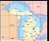
Geography of Michigan
Encyclopedia
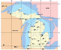
Michigan
Michigan is a U.S. state located in the Great Lakes Region of the United States of America. The name Michigan is the French form of the Ojibwa word mishigamaa, meaning "large water" or "large lake"....
consists of two peninsulas that lie between 82°30' to about 90°30' west longitude, and are separated by the Straits of Mackinac, and some nearby islands. With the exception of two small areas that are drained by the Mississippi River
Mississippi River
The Mississippi River is the largest river system in North America. Flowing entirely in the United States, this river rises in western Minnesota and meanders slowly southwards for to the Mississippi River Delta at the Gulf of Mexico. With its many tributaries, the Mississippi's watershed drains...
by way of the Wisconsin River
Wisconsin River
-External links:* * * , Wisconsin Historical Society* * * *...
in the Upper Peninsula and by way of the Kankakee
Kankakee River
The Kankakee River is a tributary of the Illinois River, approximately long, in northwestern Indiana and northeastern Illinois in the United States. At one time the river drained one of the largest wetlands in North America and furnished a significant portage between the Great Lakes and the...
-Illinois River
Illinois River
The Illinois River is a principal tributary of the Mississippi River, approximately long, in the State of Illinois. The river drains a large section of central Illinois, with a drainage basin of . This river was important among Native Americans and early French traders as the principal water route...
in the Lower Peninsula, Michigan is drained by the Great Lakes
Great Lakes
The Great Lakes are a collection of freshwater lakes located in northeastern North America, on the Canada – United States border. Consisting of Lakes Superior, Michigan, Huron, Erie, and Ontario, they form the largest group of freshwater lakes on Earth by total surface, coming in second by volume...
-St. Lawrence watershed and is the only state with the majority of its land thus drained.
Great Lakes
The Great Lakes that border Michigan from east to west are Lake ErieLake Erie
Lake Erie is the fourth largest lake of the five Great Lakes in North America, and the tenth largest globally. It is the southernmost, shallowest, and smallest by volume of the Great Lakes and therefore also has the shortest average water residence time. It is bounded on the north by the...
, Lake Huron
Lake Huron
Lake Huron is one of the five Great Lakes of North America. Hydrologically, it comprises the larger portion of Lake Michigan-Huron. It is bounded on the east by the Canadian province of Ontario and on the west by the state of Michigan in the United States...
, Lake Michigan
Lake Michigan
Lake Michigan is one of the five Great Lakes of North America and the only one located entirely within the United States. It is the second largest of the Great Lakes by volume and the third largest by surface area, after Lake Superior and Lake Huron...
, and Lake Superior
Lake Superior
Lake Superior is the largest of the five traditionally-demarcated Great Lakes of North America. It is bounded to the north by the Canadian province of Ontario and the U.S. state of Minnesota, and to the south by the U.S. states of Wisconsin and Michigan. It is the largest freshwater lake in the...
. Because of the lakes, Michigan has more lighthouse
Lighthouse
A lighthouse is a tower, building, or other type of structure designed to emit light from a system of lamps and lenses or, in older times, from a fire, and used as an aid to navigation for maritime pilots at sea or on inland waterways....
s than any other state. The state is bounded on the south by the states of Ohio
Ohio
Ohio is a Midwestern state in the United States. The 34th largest state by area in the U.S.,it is the 7th‑most populous with over 11.5 million residents, containing several major American cities and seven metropolitan areas with populations of 500,000 or more.The state's capital is Columbus...
and Indiana
Indiana
Indiana is a US state, admitted to the United States as the 19th on December 11, 1816. It is located in the Midwestern United States and Great Lakes Region. With 6,483,802 residents, the state is ranked 15th in population and 16th in population density. Indiana is ranked 38th in land area and is...
, sharing land and water boundaries with both.
Michigan's western boundaries are almost entirely water boundaries, from south to north, with Illinois
Illinois
Illinois is the fifth-most populous state of the United States of America, and is often noted for being a microcosm of the entire country. With Chicago in the northeast, small industrial cities and great agricultural productivity in central and northern Illinois, and natural resources like coal,...
and Wisconsin
Wisconsin
Wisconsin is a U.S. state located in the north-central United States and is part of the Midwest. It is bordered by Minnesota to the west, Iowa to the southwest, Illinois to the south, Lake Michigan to the east, Michigan to the northeast, and Lake Superior to the north. Wisconsin's capital is...
in Lake Michigan; then a land boundary with Wisconsin and the Upper Peninsula, that is principally demarcated by the Menominee
Menominee River
The Menominee River is a river in northwestern Michigan and northeastern Wisconsin in the United States. It is approximately 118 mi , draining a rural forested area of northern Wisconsin and the Upper Peninsula of Michigan into Lake Michigan...
and Montreal River
Montreal River (Wisconsin-Michigan)
The Montreal River is a river flowing to Lake Superior in northern Wisconsin and the Upper Peninsula of Michigan in the United States. It is approximately 40 miles long and drains approximately 270 square miles in a forested region. For most of its length, the river's course is used to define a...
s; then water boundaries again, in Lake Superior, with Wisconsin and Minnesota
Minnesota
Minnesota is a U.S. state located in the Midwestern United States. The twelfth largest state of the U.S., it is the twenty-first most populous, with 5.3 million residents. Minnesota was carved out of the eastern half of the Minnesota Territory and admitted to the Union as the thirty-second state...
to the west, capped around by the Canadian province of Ontario
Ontario
Ontario is a province of Canada, located in east-central Canada. It is Canada's most populous province and second largest in total area. It is home to the nation's most populous city, Toronto, and the nation's capital, Ottawa....
to the north and east.
The northern boundary then runs completely through Lake Superior, from the western boundary with Minnesota to a point north of and around Isle Royale
Isle Royale
Isle Royale is an island of the Great Lakes, located in the northwest of Lake Superior, and part of the state of Michigan. The island and the 450 surrounding smaller islands and waters make up Isle Royale National Park....
, thence traveling southeastward through the lake in a reasonably straight line to the Sault Ste. Marie area. In Southeastern Michigan there is a water boundary with Canada along the entire lengths of the St. Clair River, Lake St. Clair (including the First Nation reserve of Walpole Island
Walpole Island
Walpole Island is an island and Indian reserve in southwestern Ontario, Canada, on the border between Ontario and Michigan in the United States. It is located in the mouth of the St. Clair River on Lake St. Clair, approximately thirty miles northeast of Detroit, Michigan, and Windsor, Ontario.In...
) and the Detroit River). The southeastern boundary ends in the western end of Lake Erie with a three-way convergence of Michigan, Ohio and Ontario.
Michigan encompasses 58,110 square miles (150,504 km²) of land, 38,575 square miles (99,909 km²) of Great Lakes waters and 1,305 square miles (3,380 km²) of inland waters. Only Alaska
Alaska
Alaska is the largest state in the United States by area. It is situated in the northwest extremity of the North American continent, with Canada to the east, the Arctic Ocean to the north, and the Pacific Ocean to the west and south, with Russia further west across the Bering Strait...
has more territorial water.
At a total of 97,990 square miles (253,793 km²), Michigan is the largest state east of the Mississippi River
Mississippi River
The Mississippi River is the largest river system in North America. Flowing entirely in the United States, this river rises in western Minnesota and meanders slowly southwards for to the Mississippi River Delta at the Gulf of Mexico. With its many tributaries, the Mississippi's watershed drains...
(inclusive of its territorial waters). Michigan claims a land area of 58110 square miles (150,504.2 km²) of land and 97990 sq mi (253,792.9 km²) total, making it the tenth largest state, but the U.S. Census Bureau claims only 56803.82 sq mi (147,121.22 km²) of land and 96716.11 sq mi (250,493.57 km²) total, making it the eleventh largest. Michigan forest
Forest
A forest, also referred to as a wood or the woods, is an area with a high density of trees. As with cities, depending where you are in the world, what is considered a forest may vary significantly in size and have various classification according to how and what of the forest is composed...
land covers nearly 52% of the state at 19300000 acres (78,104.4 km²).
Upper Peninsula
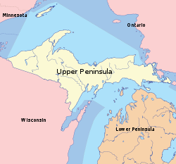
Porcupine Mountains
The Porcupine Mountains, or Porkies, are a group of small mountains spanning across the northwestern Upper Peninsula of Michigan in Ontonagon and Gogebic counties, near the shore of Lake Superior. The area is part of the Porcupine Mountains Wilderness State Park...
, which are part of one of the oldest mountain chains in the world, rise to an altitude of almost 2,000 feet (610 m) above sea level and form the watershed between the streams flowing into Lake Superior and Lake Michigan. The surface on either side of this range is rugged. The state's highest point, in the Huron Mountains
Huron Mountains
The Huron Mountains are located in the Upper Peninsula of the U.S. state of Michigan, mostly in Marquette and Baraga counties, overlooking Lake Superior. Their highest peak is Mount Arvon which, at above sea level, is the highest point in the state of Michigan. Nearby Mt...
northwest of Marquette, is Mount Arvon
Mount Arvon
Mount Arvon, elevation 1,979 feet , located in L'Anse Township, Baraga County, is the highest natural point in the U.S. state of Michigan. Like nearby Arvon Township, Michigan, Mt. Arvon takes its name from the deposits of slate in the area which were reminiscent of those around Caernarfon in...
at 1,979 feet (603 m). The peninsula is as large as Connecticut, Delaware, Massachusetts, and Rhode Island combined but has fewer than 330,000 inhabitants. They are sometimes called "Yoopers" (from "U.P.'ers"), and their speech (the "Yooper dialect
Yooper dialect
Yooper is a form of North Central American English mostly spoken in the Upper Peninsula of Michigan, which gives the dialect its name...
") has been heavily influenced by the numerous Scandinavia
Scandinavia
Scandinavia is a cultural, historical and ethno-linguistic region in northern Europe that includes the three kingdoms of Denmark, Norway and Sweden, characterized by their common ethno-cultural heritage and language. Modern Norway and Sweden proper are situated on the Scandinavian Peninsula,...
n and Canadian immigrants who settled the area during the lumbering and mining boom of the late nineteenth century.
The geographic orientation of Michigan's peninsulas makes for a long distance between the ends of the state. Ironwood
Ironwood, Michigan
Ironwood is a city in Gogebic County in the U.S. state of Michigan, about south of Lake Superior. The population was 6,293 at the 2000 census. The city is on US 2 and is situated opposite the Montreal River from Hurley, Wisconsin. It is the westernmost city in Michigan, situated on the same line...
, in the far western Upper Peninsula, lies 630 highway miles (1,015 km) from Lambertville
Lambertville, Michigan
Lambertville is an unincorporated community in Monroe County in the U.S. state of Michigan. It is also the name of the area served by the Lambertville Post Office. The Lambertville ZIP code, 48144, serves the southwest part of Bedford Township, as well as portions of adjacent Whiteford Township....
in the Lower Peninsula's southeastern corner. The geographic isolation of the Upper Peninsula from Michigan's political and population centers makes the U.P. culturally and economically distinct. Occasionally U.P. residents have called for secession
Secession
Secession is the act of withdrawing from an organization, union, or especially a political entity. Threats of secession also can be a strategy for achieving more limited goals.-Secession theory:...
from Michigan and establishment as a new state to be called "Superior."
Lower Peninsula
Moraine
A moraine is any glacially formed accumulation of unconsolidated glacial debris which can occur in currently glaciated and formerly glaciated regions, such as those areas acted upon by a past glacial maximum. This debris may have been plucked off a valley floor as a glacier advanced or it may have...
s usually not more than a few hundred feet tall. It is divided by a low water divide running north and south. The larger portion of the state is on the west of this and gradually slopes toward Lake Michigan. The highest point in the Lower Peninsula is either Briar Hill at 1,705 feet (520 m), or one of several points nearby in the vicinity of Cadillac
Cadillac, Michigan
Cadillac is a city in the U.S. state of Michigan and is the county seat of Wexford County. As of the 2000 census, the city population was 10,000. The city is situated at the junction of US 131, M-55 and M-115...
. The lowest point is the surface of Lake Erie at 571 feet (174 m).
A feature of Michigan that gives it the distinct shape of a mitten is the Thumb
The Thumb
The Thumb is a region and a peninsula of Michigan, so named because the Lower Peninsula is shaped like a mitten; thus the Thumb is the area that looks like the thumb of the mitten. The Thumb is generally considered to be in the Mid-Michigan area of the state, located east of Flint/Tri-Cities...
. This peninsula projects out into Lake Huron and the Saginaw Bay
Saginaw Bay
Saginaw Bay is a bay within Lake Huron located on the eastern side of the U.S. state of Michigan. It forms the space between Michigan's Thumb region and the rest of the Lower Peninsula of Michigan. Saginaw Bay is in area...
. The geography of the Thumb is mainly flat with a few rolling hills. Other peninsulas of Michigan include the Keweenaw Peninsula
Keweenaw Peninsula
The Keweenaw Peninsula is the northern-most part of Michigan's Upper Peninsula. It projects into Lake Superior and was the site of the first copper boom in the United States. As of the 2000 census, its population was roughly 43,200...
, making up the Copper Country
Copper Country
The Copper Country is an area in the Upper Peninsula of Michigan in the United States, including all of Keweenaw County, Michigan and most of Houghton, Baraga and Ontonagon counties. The area is so named as copper mining was prevalent there from 1845 until the late 1960s, with one mine ...
region of the state. The Leelanau Peninsula
Leelanau County, Michigan
-History:The county's name is said to be a Native American word meaning "delight of life", but it is a neologism made up by Indian agent and ethnographer Henry Schoolcraft, who sometimes gave the name "Leelinau" to Native American women in his tales. He created many faux Indian place names in...
lies in the Northern Lower Michigan
Northern Michigan
Northern Michigan, also known as Northern Lower Michigan , is a region of the U.S. state of Michigan...
region. See Also Michigan Regions
Lakes and rivers
Lake
A lake is a body of relatively still fresh or salt water of considerable size, localized in a basin, that is surrounded by land. Lakes are inland and not part of the ocean and therefore are distinct from lagoons, and are larger and deeper than ponds. Lakes can be contrasted with rivers or streams,...
s and marsh
Marsh
In geography, a marsh, or morass, is a type of wetland that is subject to frequent or continuous flood. Typically the water is shallow and features grasses, rushes, reeds, typhas, sedges, other herbaceous plants, and moss....
es mark both peninsulas, and the coast is much indented. Keweenaw Bay, Whitefish Bay
Whitefish Bay
Whitefish Bay is a large bay on the eastern end of the southern shore of Lake Superior between Michigan and Ontario. It begins in the north and west at Whitefish Point in Michigan, about 10 miles north of Paradise, Michigan and ends at the St. Marys River at Sault Ste. Marie on the southeast...
, and the Big and Little
Little Bay de Noc
Little Bay de Noc is a bay in the Upper Peninsula of the U.S. state of Michigan. The bay opens into Lake Michigan's Green Bay.The bay, consisting of approximately 30,000 acres , is enclosed by Delta County...
Bays De Noc are the principal indentations on the Upper Peninsula. The Grand
Grand Traverse Bay
Grand Traverse Bay is a bay of Lake Michigan formed by part of Northern Michigan. The bay is long, 10 miles wide, and up to deep in spots. It is divided into two arms by the Old Mission Peninsula...
and Little Traverse
Little Traverse Bay
Little Traverse Bay is a small bay, 170 feet deep, off Lake Michigan in the northern area of the Lower Peninsula of Michigan. Harbor Springs and Petoskey are on this bay.The Little Traverse Light marks its entrance....
, Thunder
Thunder Bay (Michigan)
Thunder Bay is a bay in the U.S. state of Michigan on Lake Huron. The bay extends from North Point at to South Point at .The city of Alpena lies at the mouth of the Thunder Bay River at...
, and Saginaw
Saginaw Bay
Saginaw Bay is a bay within Lake Huron located on the eastern side of the U.S. state of Michigan. It forms the space between Michigan's Thumb region and the rest of the Lower Peninsula of Michigan. Saginaw Bay is in area...
bays indent the Lower Peninsula. After Alaska, Michigan has the longest shoreline of any state—3,288 miles (5,326 km). An additional 1,056 miles (1,699 km) can be added if islands are included. This roughly equals the length of the Atlantic Coast from Maine to Florida.
The state has numerous large islands
Islands of Michigan
The following is a list of islands of Michigan. Michigan has the second longest coastline of any state after Alaska. Being bordered by four of the five Great Lakes—Erie, Huron, Michigan, and Superior—Michigan also has 64,980 inland lakes and ponds, as well as innumerable rivers, that may contain...
, the principal ones being the Manitou, Beaver
Beaver Island (Lake Michigan)
Beaver Island is the largest island in Lake Michigan and part of the Beaver Island archipelago. Once home to a unique American monarchy, the island is now a popular tourist and vacation destination....
, and Fox
Fox Islands (Michigan)
The Fox Islands consist of the North Fox and South Fox islands, in Lake Michigan. The uninhabited islands are approximately 17 miles northwest of Cathead Point near the tip of the Leelanau Peninsula of Michigan and about southwest of Beaver Island. The three islands form part of an archipelago...
groups in Lake Michigan; Isle Royale
Isle Royale
Isle Royale is an island of the Great Lakes, located in the northwest of Lake Superior, and part of the state of Michigan. The island and the 450 surrounding smaller islands and waters make up Isle Royale National Park....
and Grande Isle in Lake Superior; Drummond, Marquette
Marquette Island
Marquette Island is the largest of the 36 islands in the Les Cheneaux archipelago of northern Michigan, United States. Located in Mackinac County on the north shore of Lake Huron, the island has a small summer population. It is 6.5 miles long and 3.5 miles wide...
, Bois Blanc
Bois Blanc Island (Michigan)
Bois Blanc Island is coterminous with Bois Blanc Township, Mackinac County in the U.S. state of Michigan. The island covers about and is about 12 miles long, 6 miles wide and has 6 lakes. Bois Blanc is located in Lake Huron southeast of Mackinac Island and almost due north of the city of...
, and Mackinac
Mackinac Island
Mackinac Island is an island and resort area covering in land area, part of the U.S. state of Michigan. It is located in Lake Huron, at the eastern end of the Straits of Mackinac, between the state's Upper and Lower Peninsulas. The island was home to a Native American settlement before European...
islands in Lake Huron; and Neebish
Neebish Island
Neebish Island is an island in the U.S. state of Michigan in the St. Marys River between the United States and the Canadian province of Ontario. It is divided into two parts known as "Big Neebish" and "Little Neebish" which are divided by a river which is sometimes more mud than river and is known...
and Sugar
Sugar Island (Michigan)
Sugar Island is an island in the U.S. state of Michigan in the St. Marys River between the United States and the Canadian province of Ontario. The entire island constitutes Sugar Island Township in Chippewa County at the eastern tip of the Upper Peninsula...
islands in St. Mary's River
St. Marys River (Michigan-Ontario)
The St. Marys River , sometimes written as the St. Mary's River, drains Lake Superior, starting at the end of Whitefish Bay and flowing 74.5 miles southeast into Lake Huron, with a fall of ....
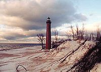
. Michigan has about 150 lighthouse
Lighthouse
A lighthouse is a tower, building, or other type of structure designed to emit light from a system of lamps and lenses or, in older times, from a fire, and used as an aid to navigation for maritime pilots at sea or on inland waterways....
s, the most of any U.S. state. The first lighthouses in Michigan were built between 1818 and 1822. They were built to project light at night and to serve as a landmark during the day to safely guide the passenger ships and freighters traveling the Great Lakes. See Lighthouses in the United States.
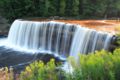
The state's rivers are small, short and shallow, and few are navigable. The principal ones include the Au Sable
Au Sable River (Michigan)
The Au Sable River in Michigan runs approximately through the northern Lower Peninsula, through the towns of Grayling and Mio, and enters Lake Huron at Oscoda. It is considered one of the best brown trout fisheries east of the Rockies and has been designated a blue ribbon trout stream by the...
, Thunder Bay
Thunder Bay River
The Thunder Bay River is a river in the U.S. state of Michigan. It drains much of Alpena County and Montmorency County, and a small portion of Oscoda County, into Thunder Bay on the eastern side of northern Michigan...
, Cheboygan
Cheboygan River
The Cheboygan River is a short but significant river in the Lake Huron drainage basin of the U.S. state of Michigan. in length, the Cheboygan River flows from the north end of Mullett Lake at to the Straits of Mackinac at . The river forms the boundary between Benton Township and Inverness...
, and Saginaw
Saginaw River
The Saginaw River is a river in the U.S. state of Michigan. It is formed by the confluence of the Tittabawassee and Shiawassee rivers southwest of Saginaw. It flows northward into the Saginaw Bay of Lake Huron just northeast of Bay City. The watershed area is .The river is an important shipping...
, all of which flow into Lake Huron; the Ontonagon
Ontonagon River
The Ontonagon River is a river flowing to Lake Superior on the western Upper Peninsula of Michigan in the United States. The main stem of the river is 25 mi long and is formed by a confluence of several longer branches, portions of which have been collectively designated as a National Wild...
, and Tahquamenon
Tahquamenon River
The Tahquamenon River is a long blackwater river in the U.S. state of Michigan that flows in a generally eastward direction through the eastern end of the Upper Peninsula. It drains approximately of the Upper Peninsula, including large sections of Luce County and Chippewa County...
, which flow into Lake Superior; and the St. Joseph
St. Joseph River (Lake Michigan)
The St. Joseph River is a river, approximately long, in southern Michigan and northern Indiana in the United States. It drains a primarily rural farming area in the watershed of Lake Michigan...
, Kalamazoo
Kalamazoo River
The Kalamazoo River is a river in the U.S. state of Michigan. The river is long from the junction of its North and South branches to its mouth at Lake Michigan, with a total length extending to when one includes the South Branch...
, Grand
Grand River (Michigan)
The Grand River is the longest river in the U.S. state of Michigan. It runs through the cities of Jackson, Eaton Rapids, Lansing, Grand Rapids, and Grand Haven.-Description:...
, Muskegon
Muskegon River
The Muskegon River is a river in the western portion of the lower peninsula of the U.S. state of Michigan. The river has its headwaters in Houghton Lake in Roscommon County, flowing out of the North Bay into neighboring Missaukee County. From there it flows mostly southwest to Muskegon, Michigan,...
, Manistee
Manistee River
The Manistee River in the U.S. state of Michigan, runs approximately 232 miles through the northern Lower Peninsula, through the villages of Sharon, Smithville, Mesick, and enters Lake Michigan at Manistee. It is considered, like the nearby Au Sable River, to be one of the best trout fisheries east...
, and Escanaba
Escanaba River
The Escanaba River is a river in the Upper Peninsula of the U.S. state of Michigan.In his poem The Song of Hiawatha, Henry Wadsworth Longfellow describes how Hiawatha "crossed the rushing Esconaba". It is a wide river that cuts into limestone beds...
, which flow into Lake Michigan. The state has 11,037 inland lakes and 38,575 square miles (62,067 km²) of Great Lakes waters and rivers in addition to 1305 square miles (3,380 km²) of inland water. No point in Michigan is more than six miles (10 km) from an inland lake or more than 85 miles (137 km) from one of the Great Lakes.
Protected areas
The state is home to one national parkNational park
A national park is a reserve of natural, semi-natural, or developed land that a sovereign state declares or owns. Although individual nations designate their own national parks differently A national park is a reserve of natural, semi-natural, or developed land that a sovereign state declares or...
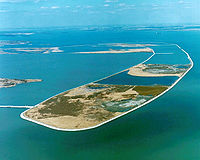
: Isle Royale National Park
Isle Royale National Park
Isle Royale National Park is a U.S. National Park in the state of Michigan. Isle Royale, the largest island in Lake Superior, is over 45 miles in length and 9 miles wide at its widest point. The park is made of Isle Royale itself and approximately 400 smaller islands, along with any submerged...
, located in Lake Superior, about 30 miles (48 km) southeast of Thunder Bay, Ontario. Other national protected areas in the state include: Keweenaw National Historical Park
Keweenaw National Historical Park
Keweenaw National Historical Park is a unit of the U.S. National Park Service. Established in 1992, the park celebrates the life and history of the Keweenaw Peninsula in the Upper Peninsula of the U.S. state of Michigan...
, Pictured Rocks National Lakeshore
Pictured Rocks National Lakeshore
Pictured Rocks National Lakeshore is a U.S. National Lakeshore on the shore of Lake Superior in the Upper Peninsula of Michigan, United States. It extends for 42 miles along the shore and covers...
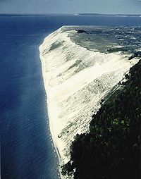
, Sleeping Bear Dunes National Lakeshore
Sleeping Bear Dunes National Lakeshore
Sleeping Bear Dunes National Lakeshore is a United States National Lakeshore located along the northwest coast of the Lower Peninsula of Michigan in Leelanau County and Benzie County....
, Huron National Forest, Manistee National Forest, Hiawatha National Forest
Hiawatha National Forest
Hiawatha National Forest is a National Forest in the Upper Peninsula of the state of Michigan in the United States. Commercial logging is conducted in some areas. The United States Forest Service administers this National Forest; it is physically divided into two subunits, commonly called the...
, Ottawa National Forest
Ottawa National Forest
The Ottawa National Forest is a 1.0 million acre national forest in the Upper Peninsula of the U.S. state of Michigan. It includes much of Gogebic and Ontonagon counties, as well as slices of Iron, Houghton, Baraga, and Marquette counties. The forest is under the jurisdiction of the U.S...
, Fumee Lake Natural Area and Father Marquette National Memorial
Father Marquette National Memorial
Father Marquette National Memorial pays tribute to the life and work of Jacques Marquette, French priest and explorer. The memorial is located in Straits State Park near St. Ignace in the modern-day U.S. state of Michigan, where he founded a Jesuit mission in 1671 and was buried in 1678...
. The largest section of the North Country National Scenic Trail also passes through Michigan.
With 78 state park
State park
State parks are parks or other protected areas managed at the federated state level within those nations which use "state" as a political subdivision. State parks are typically established by a state to preserve a location on account of its natural beauty, historic interest, or recreational...
s, 19 state recreation areas, and 6 state forests, Michigan has the largest state park and state forest
State forest
A state forest is a forest that is administered or protected by some agency of a sovereign state.The precise application of the term varies by jurisdiction...
system of any state. These parks and forests include Holland State Park
Holland State Park
Holland State Park is located in the U.S. state of Michigan, in Park Township, Ottawa County, four miles west of the city of Holland. The park covers about on the northern side of the channel connecting Lake Macatawa with Lake Michigan, and consists of separate Lake Macatawa and Lake Michigan...
, Mackinac Island State Park
Mackinac Island State Park
Mackinac Island State Park is a state park located on Mackinac Island in the U.S. state of Michigan. The island park encompasses 2.81 mi² , which is approximately 74% of the island's total area of 3.78 mi² . The park is also within the boundaries of the city of Mackinac Island and has permanent...
, Au Sable State Forest
Au Sable State Forest
The Au Sable State Forest is a state forest in the north-central Lower Peninsula of Michigan. It is operated by the Michigan Department of Natural Resources....
, and Mackinaw State Forest
Mackinaw State Forest
The Mackinaw State Forest is a forested area owned by the U.S. state of Michigan and operated by the Michigan Department of Natural Resources. It is located in the northern area of the Lower Peninsula within the eight counties of Alpena, Antrim, Charlevoix, Cheboygan, Emmet, Montmorency, Otsego,...
.
Climate
Humid continental climate
A humid continental climate is a climatic region typified by large seasonal temperature differences, with warm to hot summers and cold winters....
, although there are two distinct regions. The southern and central parts of the Lower Peninsula (south of Saginaw Bay
Saginaw Bay
Saginaw Bay is a bay within Lake Huron located on the eastern side of the U.S. state of Michigan. It forms the space between Michigan's Thumb region and the rest of the Lower Peninsula of Michigan. Saginaw Bay is in area...
and from the Grand Rapids area southward) have a warmer climate (Koppen climate classification
Köppen climate classification
The Köppen climate classification is one of the most widely used climate classification systems. It was first published by Crimea German climatologist Wladimir Köppen in 1884, with several later modifications by Köppen himself, notably in 1918 and 1936...
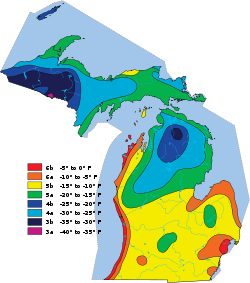
Dfa) with hot summers and cold winters. The northern part of Lower Peninsula and the entire Upper Peninsula has a more severe climate (Koppen Dfb), with warm, but shorter summers and longer, cold to very cold winters. Some parts of the state average high temperatures below freezing from December through February, and into early March in the far northern parts. During the winter through the middle of February the state is frequently subjected to heavy lake-effect snow. The state averages from 30-40 inches (75–100 cm) of precipitation annually.
The entire state averages 30 days of thunderstorm activity per year. These can be severe, especially in the southern part of the state. The state averages 17 tornado
Tornado
A tornado is a violent, dangerous, rotating column of air that is in contact with both the surface of the earth and a cumulonimbus cloud or, in rare cases, the base of a cumulus cloud. They are often referred to as a twister or a cyclone, although the word cyclone is used in meteorology in a wider...
es per year, which are more common in the extreme southern portion of the state. Portions of the southern border have been nearly as vulnerable historically as parts of Tornado Alley
Tornado Alley
Tornado Alley is a colloquial and popular media term that most often refers to the area of the United States where tornadoes are most frequent. Although an official location is not defined, the area between the Rocky Mountains and Appalachian Mountains is usually associated with it.The areas...
. Farther north, in the Upper Peninsula, tornadoes are rare.
| Monthly Normal High and Low Temperatures For Various Michigan Cities in °F(°C) | ||||||||||||
| City | Jan | Feb | Mar | Apr | May | Jun | Jul | Aug | Sep | Oct | Nov | Dec |
|---|---|---|---|---|---|---|---|---|---|---|---|---|
| Detroit | 31/18 (-1/-8) |
34/20 (1/-7) |
45/28 (7/-2) |
58/38 (14/3) |
70/49 (21/9) |
79/59 (26/15) |
83/64 (28/18) |
81/62 (27/17) |
74/54 (23/12) |
61/42 (16/6) |
48/34 (9/1) |
36/23 (2/-5) |
| Flint | 29/13 (-2/-11) |
32/15 (0/-9) |
43/24 (6/-4) |
56/35 (13/2) |
69/45 (21/7) |
78/55 (26/13) |
82/59 (28/15) |
80/57 (27/14) |
72/49 (22/9) |
60/39 (16/4) |
46/30 (8/-1) |
34/19 (1/-7) |
| Grand Rapids | 29/16 (-2/-9) |
33/17 (1/-8) |
43/26 (6/-3) |
57/36 (14/2) |
70/47 (21/8) |
78/56 (26/13) |
82/60 (28/16) |
80/59 (27/15) |
72/51 (22/11) |
60/40 (11/4) |
46/31 (8/-1) |
34/21 (1/-6) |
| Lansing | 29/14 (-2/-10) |
33/15 (1/-9) |
44/24 (7/-4) |
57/34 (14/1) |
69/45 (21/7) |
78/54 (26/12) |
82/58 (28/14) |
80/57 (27/14) |
72/49 (22/9) |
60/39 (16/4) |
46/30 (8/-1) |
34/20 (1/-7) |
| Marquette | 20/3 (-7/-16) |
24/5 (-4/-15) |
33/14 (1/-10) |
46/27 (8/-3) |
62/39 (17/4) |
70/48 (21/9) |
75/54 (24/12) |
73/52 (23/11) |
63/44 (17/7) |
51/34 (11/1) |
35/22 (2/-6) |
24/10 (-4/-12) |
| Muskegon | 30/17 (-1/-8) |
32/18 (0/-8) |
42/25 (6/-4) |
55/35 (13/2) |
67/45 (19/7) |
76/54 (24/12) |
80/60 (27/16) |
78/59 (26/15) |
70/51 (21/11) |
59/41 (15/5) |
46/32 (8/0) |
35/23 (2/-5) |
| Sault Ste Marie | 22/5 (-6/-15) |
24/7 (-4/-14) |
34/16 (1/-9) |
48/29 (9/-2) |
63/39 (17/4) |
71/46 (22/7) |
76/52 (24/11) |
74/52 (23/11) |
65/45 (18/7) |
53/36 (12/2) |
39/26 (12/-3) |
27/13 (-3/-11) |
| http://www.ustravelweather.com/weather-michigan/ | ||||||||||||
Geology
Silurian
The Silurian is a geologic period and system that extends from the end of the Ordovician Period, about 443.7 ± 1.5 Mya , to the beginning of the Devonian Period, about 416.0 ± 2.8 Mya . As with other geologic periods, the rock beds that define the period's start and end are well identified, but the...
sandstones, limestones, copper and iron bearing rocks, corresponding to the Huronian system of Canada
Canada
Canada is a North American country consisting of ten provinces and three territories. Located in the northern part of the continent, it extends from the Atlantic Ocean in the east to the Pacific Ocean in the west, and northward into the Arctic Ocean...
. The central portion of the Lower Peninsula contains coal measures and rocks of the Permo-Carboniferous
Permo-Carboniferous
The Permo-Carboniferous refers to the time period including the latter parts of the Carboniferous and early part of the Permian period. Permo-Carboniferous rocks are in places not differentiated because of the presence of transitional fossils, and also where no conspicuous stratigraphic break is...
period. Devonian
Devonian
The Devonian is a geologic period and system of the Paleozoic Era spanning from the end of the Silurian Period, about 416.0 ± 2.8 Mya , to the beginning of the Carboniferous Period, about 359.2 ± 2.5 Mya...
and sub-Carboniferous deposits are scattered over the entire state.
The soil is of a varied composition and in large areas is very fertile, especially in the south. However, the Upper Peninsula for the most part is rocky and mountainous, and the soil is unsuitable for agriculture. The climate is tempered by the proximity of the lakes and is much milder than in other locales with the same latitude. The principal forest trees include basswood, maple
Maple
Acer is a genus of trees or shrubs commonly known as maple.Maples are variously classified in a family of their own, the Aceraceae, or together with the Hippocastanaceae included in the family Sapindaceae. Modern classifications, including the Angiosperm Phylogeny Group system, favour inclusion in...
, elm
Elm
Elms are deciduous and semi-deciduous trees comprising the genus Ulmus in the plant family Ulmaceae. The dozens of species are found in temperate and tropical-montane regions of North America and Eurasia, ranging southward into Indonesia. Elms are components of many kinds of natural forests...
, sassafras
Sassafras
Sassafras is a genus of three extant and one extinct species of deciduous trees in the family Lauraceae, native to eastern North America and eastern Asia.-Overview:...
, butternut, walnut
Walnut
Juglans is a plant genus of the family Juglandaceae, the seeds of which are known as walnuts. They are deciduous trees, 10–40 meters tall , with pinnate leaves 200–900 millimetres long , with 5–25 leaflets; the shoots have chambered pith, a character shared with the wingnuts , but not the hickories...
, poplar
Poplar
Populus is a genus of 25–35 species of deciduous flowering plants in the family Salicaceae, native to most of the Northern Hemisphere. English names variously applied to different species include poplar , aspen, and cottonwood....
, hickory
Hickory
Trees in the genus Carya are commonly known as hickory, derived from the Powhatan language of Virginia. The genus includes 17–19 species of deciduous trees with pinnately compound leaves and big nuts...
, oak
Oak
An oak is a tree or shrub in the genus Quercus , of which about 600 species exist. "Oak" may also appear in the names of species in related genera, notably Lithocarpus...
, willow
Willow
Willows, sallows, and osiers form the genus Salix, around 400 species of deciduous trees and shrubs, found primarily on moist soils in cold and temperate regions of the Northern Hemisphere...
, pine
Pine
Pines are trees in the genus Pinus ,in the family Pinaceae. They make up the monotypic subfamily Pinoideae. There are about 115 species of pine, although different authorities accept between 105 and 125 species.-Etymology:...
, birch
Birch
Birch is a tree or shrub of the genus Betula , in the family Betulaceae, closely related to the beech/oak family, Fagaceae. The Betula genus contains 30–60 known taxa...
, beech
Beech
Beech is a genus of ten species of deciduous trees in the family Fagaceae, native to temperate Europe, Asia and North America.-Habit:...
, hemlock
Tsuga
Tsuga is a genus of conifers in the family Pinaceae. The common name hemlock is derived from a perceived similarity in the smell of its crushed foliage to that of the unrelated plant poison hemlock....
, witchhazel, tamarack, cedar
Cedar wood
Cedar wood comes from several different trees that grow in different parts of the world, and may have different uses.* California incense-cedar, from Calocedrus decurrens, is the primary type of wood used for making pencils...
, locust
Locust
Locusts are the swarming phase of short-horned grasshoppers of the family Acrididae. These are species that can breed rapidly under suitable conditions and subsequently become gregarious and migratory...
, dogwood
Dogwood
The genus Cornus is a group of about 30-60 species of woody plants in the family Cornaceae, commonly known as dogwoods. Most dogwoods are deciduous trees or shrubs, but a few species are nearly herbaceous perennial subshrubs, and a few of the woody species are evergreen...
, and ash.