

Geography of Mesopotamia
Encyclopedia
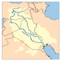
Tigris
The Tigris River is the eastern member of the two great rivers that define Mesopotamia, the other being the Euphrates. The river flows south from the mountains of southeastern Turkey through Iraq.-Geography:...
and Euphrates
Euphrates
The Euphrates is the longest and one of the most historically important rivers of Western Asia. Together with the Tigris, it is one of the two defining rivers of Mesopotamia...
. While the southern is flat and marshy; the near approach of the two rivers to one another, at a spot where the undulating plateau of the north sinks suddenly into the Babylonian alluvium, tends to separate them still more completely. In the earliest recorded times, the northern portion was included in Mesopotamia
Mesopotamia
Mesopotamia is a toponym for the area of the Tigris–Euphrates river system, largely corresponding to modern-day Iraq, northeastern Syria, southeastern Turkey and southwestern Iran.Widely considered to be the cradle of civilization, Bronze Age Mesopotamia included Sumer and the...
; it was marked off as Assyria after the rise of the Assyrian monarchy. Apart from Assur
Assur
Assur , was one of the capitals of ancient Assyria. The remains of the city are situated on the western bank of river Tigris, north of the confluence with the tributary Little Zab river, in modern day Iraq, more precisely in the Al-Shirqat District .Assur is also...
, the original capital, the chief cities of the country, Nineveh
Nineveh
Nineveh was an ancient Assyrian city on the eastern bank of the Tigris River, and capital of the Neo Assyrian Empire. Its ruins are across the river from the modern-day major city of Mosul, in the Ninawa Governorate of Iraq....
, Calah and Arbela
Arbil
Arbil / Hewlêr is the fourth largest city in Iraq after Baghdad, Basra and Mosul...
, were all on the east bank of the Tigris. The reason was its abundant supply of water, whereas the great Mesopotamian plain on the western side had to depend on streams flowing into the Euphrates.
Defining Mesopotamia
Mesopotamia literally means "(Land) between rivers" in ancient GreekAncient Greek
Ancient Greek is the stage of the Greek language in the periods spanning the times c. 9th–6th centuries BC, , c. 5th–4th centuries BC , and the c. 3rd century BC – 6th century AD of ancient Greece and the ancient world; being predated in the 2nd millennium BC by Mycenaean Greek...
. The oldest known occurrence of the name Mesopotamia dates to the 4th century BCE, when it was used to designate the land east of the Euphrates
Euphrates
The Euphrates is the longest and one of the most historically important rivers of Western Asia. Together with the Tigris, it is one of the two defining rivers of Mesopotamia...
in north Syria
Syria
Syria , officially the Syrian Arab Republic , is a country in Western Asia, bordering Lebanon and the Mediterranean Sea to the West, Turkey to the north, Iraq to the east, Jordan to the south, and Israel to the southwest....
. Later it was more generally applied to all the lands between the Euphrates and the Tigris
Tigris
The Tigris River is the eastern member of the two great rivers that define Mesopotamia, the other being the Euphrates. The river flows south from the mountains of southeastern Turkey through Iraq.-Geography:...
, thereby incorporating not only parts of Syria but also almost all of Iraq
Iraq
Iraq ; officially the Republic of Iraq is a country in Western Asia spanning most of the northwestern end of the Zagros mountain range, the eastern part of the Syrian Desert and the northern part of the Arabian Desert....
and southeastern Turkey
Turkey
Turkey , known officially as the Republic of Turkey , is a Eurasian country located in Western Asia and in East Thrace in Southeastern Europe...
. The neighbouring steppes to the west of the Euphrates and the western part of the Zagros Mountains
Zagros Mountains
The Zagros Mountains are the largest mountain range in Iran and Iraq. With a total length of 1,500 km , from northwestern Iran, and roughly correlating with Iran's western border, the Zagros range spans the whole length of the western and southwestern Iranian plateau and ends at the Strait of...
are also often included under the wider term Mesopotamia. A further distinction is usually made between Upper or Northern Mesopotamia and Lower or Southern Mesopotamia. Upper Mesopotamia, also known as the Jezirah
Al-Jazira, Mesopotamia
Upper Mesopotamia is the name used for the uplands and great outwash plain of northwestern Iraq and northeastern Syria and southeastern Turkey which is known by the traditional Arabic name of Al-Jazira , variously transliterated into Roman script as Djazirah, Djezirah and Jazirah...
, is the area between the Euphrates and the Tigris from their sources down to Baghdad
Baghdad
Baghdad is the capital of Iraq, as well as the coterminous Baghdad Governorate. The population of Baghdad in 2011 is approximately 7,216,040...
. Lower Mesopotamia is the area from Baghdad to the Persian Gulf
Persian Gulf
The Persian Gulf, in Southwest Asia, is an extension of the Indian Ocean located between Iran and the Arabian Peninsula.The Persian Gulf was the focus of the 1980–1988 Iran-Iraq War, in which each side attacked the other's oil tankers...
. In modern scientific usage, the term Mesopotamia often also has a chronological connotation. It is usually used to designate the area until the Muslim conquests
Muslim conquests
Muslim conquests also referred to as the Islamic conquests or Arab conquests, began with the Islamic prophet Muhammad. He established a new unified polity in the Arabian Peninsula which under the subsequent Rashidun and Umayyad Caliphates saw a century of rapid expansion of Muslim power.They...
in the 7th century CE, with names like Syria, Jezirah and Iraq being used to describe the region after that date.
Upper Mesopotamia
This vast flat, the modern El-Jezireh, is about 250 miles (402.3 km) in length, interrupted only by a single limestone range rising abruptly out of the plain, and branching off from the Zagros mountains under the names of Sarazur, Hainrin and SinjarSinjar
Sinjar is the name of a town and district in northwestern Iraq's Ninawa Governorate near the Syrian border. Its population at the time of the 2006 census was 39,875....
. The numerous remains of old habitations show how thickly this level tract must once have been peopled, though now mostly a wilderness. North of the plateau rises a well-watered and undulating belt of country, into which run low ranges of limestone hills, sometimes arid, sometimes covered with dwarf oak, and often shutting in, between their northern and northeastern flank and the main mountain line from which they detach themselves, rich plains and fertile valleys. Behind them tower the massive ridges of the Euphrates and Zagros ranges, where the Tigris and Euphrates take their rise, and which cut off Assyria from Armenia
Armenia
Armenia , officially the Republic of Armenia , is a landlocked mountainous country in the Caucasus region of Eurasia...
and Kurdistan. The name Assyria itself was derived from that of the city of Assur or Asur
Asur
Asur is a village in the Kumbakonam taluk of Thanjavur district, Tamil Nadu.- Demographics :As per the 2001 census, Asur had a total population of 2212 with 1095 males and 1117 females. The sex ratio was 1020. The literacy rate was 67.47....
, now Qal'at Sherqat (Kaleh Shergat), on the right bank of the Tigris, midway between the Greater
Great Zab
The Great Zab , , , ) is an approximately long river flowing through Turkey and Iraq. It rises in Turkey near Lake Van and joins the Tigris in Iraq south of Mosul. The drainage basin of the Great Zab covers approximately , and during its course, the rivers collects the water from a large number...
and the Lesser Zab
Little Zab
The Little Zab , , ) originates in Iran and joins the Tigris in Iraq. The river is approximately long and drains an area of c. . The river is fed by rainfall and snowmelt, resulting in a peak discharge in spring and low water in summer and early fall...
. It remained the capital long after the Assyrians had become the dominant power in western Asia
Asia
Asia is the world's largest and most populous continent, located primarily in the eastern and northern hemispheres. It covers 8.7% of the Earth's total surface area and with approximately 3.879 billion people, it hosts 60% of the world's current human population...
, but was finally supplanted by Calah (Nimrud
Nimrud
Nimrud is an ancient Assyrian city located south of Nineveh on the river Tigris in modern Ninawa Governorate Iraq. In ancient times the city was called Kalḫu. The Arabs called the city Nimrud after the Biblical Nimrod, a legendary hunting hero .The city covered an area of around . Ruins of the city...
), Nineveh (Nebi Vunus and Kuyunjik), and Dur-Sargina (Khorsabad), some 60 miles (96.6 km) farther north.
Lower Mesopotamia
In contrast with the arid plateau of Mesopotamia stretched the rich alluvial plain of ChaldeaChaldea
Chaldea or Chaldaea , from Greek , Chaldaia; Akkadian ; Hebrew כשדים, Kaśdim; Aramaic: ܟܐܠܕܘ, Kaldo) was a marshy land located in modern-day southern Iraq which came to briefly rule Babylon...
, formed by the deposits of the two great rivers that encircled it. The soil was extremely fertile, and teemed with an industrious population. Eastward rose the mountains of Elam, southward were the sea-marshes and the Kaldy or Chaldeans and other Aramaic tribes, while on the west the civilization of Babylonia encroached beyond the banks of the Euphrates, upon the territory of the Semitic
Semitic
In linguistics and ethnology, Semitic was first used to refer to a language family of largely Middle Eastern origin, now called the Semitic languages...
nomads (or Suti). Here stood Ur
Ur
Ur was an important city-state in ancient Sumer located at the site of modern Tell el-Muqayyar in Iraq's Dhi Qar Governorate...
(Mugheir, more correctly Muqayyar) the earliest capital of the country; and Babylon, with its suburb, Borsippa
Borsippa
Borsippa was an important ancient city of Sumer, built on both sides of a lake about southwest of Babylon on the east bank of the Euphrates. The site of Borsippa is in Babil Governorate, Iraq and now called Birs Nimrud, identifying the site with Nimrod...
(Birs Nimrud), as well as the two Sippar
Sippar
Sippar was an ancient Near Eastern city on the east bank of the Euphrates river, located at the site of modern Tell Abu Habbah in Iraq's Babil Governorate, some 60 km north of Babylon and 30 km southeast of Baghdad....
s (the Sepharvaim of Scripture, now Abu Habba), occupied both the Arabian and Chaldaean sides of the river. The Arakhtu, or "river of Babylon," flowed past the southern side of the city, and to the southwest of it on the Arabian bank lay the great inland freshwater sea of Najaf
Najaf
Najaf is a city in Iraq about 160 km south of Baghdad. Its estimated population in 2008 is 560,000 people. It is the capital of Najaf Governorate...
, surrounded by red sandstone cliffs of considerable height, 40 miles (64.4 km) in length and 35 in breadth in the widest part. Above and below this sea, from Borsippa to Kufa, extend the famous Chaldaean marshes, where Alexander the Great was nearly lost (Arrian, Eup. Al. vii. 22; Strabo xvi. I, § 12); but these depend upon the state of the Hindiya canal, disappearing altogether when it is closed.
Eastward of the Euphrates and southward of Sippara, Kutha and Babylon were Kish
Kish (Sumer)
Kish is modern Tell al-Uhaymir , and was an ancient city of Sumer. Kish is located some 12 km east of Babylon, and 80 km south of Baghdad ....
(Ultaimir, 9 miles (14.5 km) E. of Hillah), Nippur
Nippur
Nippur was one of the most ancient of all the Sumerian cities. It was the special seat of the worship of the Sumerian god Enlil, the "Lord Wind," ruler of the cosmos subject to An alone...
(Niffer)-where stood the great sanctuary of El-lu, the older Bel-Uruk or Erech
Erech
Erech according to the Book of Genesis, was an ancient city in the land of Shinar, the second city built by king Nimrod....
(Warka) and Larsa
Larsa
Larsa was an important city of ancient Sumer, the center of the cult of the sun god Utu. It lies some 25 km southeast of Uruk in Iraq's Dhi Qar Governorate, near the east bank of the Shatt-en-Nil canal at the site of the modern settlement Tell as-Senkereh or Sankarah.-History:According to...
(Senkera) with its temple of the sun-god, while eastward of the Shatt el-Hai, probably the ancient channel of the Tigris, was Lagash
Lagash
Lagash is located northwest of the junction of the Euphrates and Tigris rivers and east of Uruk, about east of the modern town of Ash Shatrah. Lagash was one of the oldest cities of the Ancient Near East...
(Tello), which played an important part in early Babylonian history.
The primitive seaport of the country, Eridu
Eridu
Eridu is an ancient Sumerian city in what is now Tell Abu Shahrain, Dhi Qar Governorate, Iraq. Eridu was considered the earliest city in southern Mesopotamia, and is one of the oldest cities in the world...
, the seat of the worship of Ea the culture-god, was a little south of Ur (at Abu Shahrain or Nowäwis on the west side of the Euphrates). It is now about 130 miles (209.2 km) from the sea; as about 46 inches of land have been formed by the silting up of the shore since the foundation of Spasinus Charax (Mu/-zamrah) in the time of Alexander the Great, or some 115 feet (35.1 m) a year, the city would have existed perhaps 6000 years ago. The marshes in the south, like the adjoining desert, were frequented by Aramaic tribes; of these, the most famous were the Kaldä or Chaldaeans who under Merodach-baladan made themselves masters of Babylon and gave their name in later days to the whole population of the country. The combined stream of the Euphrates and Tigris as it flowed through the marshes was known to the Babylonians as the ndr marrati, "the salt river" (cp. Jeremiah
Book of Jeremiah
The Book of Jeremiah is the second of the Latter Prophets in the Hebrew Bible, following the book of Isaiah and preceding Ezekiel and the Book of the Twelve....
1:21), a name originally applied to the Persian Gulf
Persian Gulf
The Persian Gulf, in Southwest Asia, is an extension of the Indian Ocean located between Iran and the Arabian Peninsula.The Persian Gulf was the focus of the 1980–1988 Iran-Iraq War, in which each side attacked the other's oil tankers...
.
The alluvial plain of Babylonia was called Edin
Edin
Edin is a Bosnian given name for males and a surname. People named Edin include:- Given name :* Edin Ademović, Bosnian footballer* Edin Bavčić, Bosnian basketball player* Edin Ćurić, Bosnian footballer* Edin Džeko, Bosnian footballer...
, though the name was properly restricted to "the plain" on the western bank of the river where the Bedouins pastured the flocks of their Babylonian masters. This "bank" or kisad, together with the corresponding western bank of the Tigris (according to Fritz Hommel
Fritz Hommel
Fritz Hommel was a German Orientalist.Hommel was born in Ansbach, Germany. He studied in Leipzig and habilitated in 1877 in Munich, where he in 1885 became an extraordinary Professor for semitic languages....
the modern Shatt el-Uai), gave its name to the land of Chesed
Chesed
The Hebrew noun khesed or chesed is the Hebrew word for "kindness." It is also commonly translated as "loving-kindness," or "love." Love is a central Jewish value, and leads to many particular commandments. Chesed is central to Jewish ethics and Jewish theology...
, whence the Kasdim/Kasdin of the Old Testament. In the early inscriptions of Lagash
Lagash
Lagash is located northwest of the junction of the Euphrates and Tigris rivers and east of Uruk, about east of the modern town of Ash Shatrah. Lagash was one of the oldest cities of the Ancient Near East...
, the whole district is known as Gu-Edinna, the Sumerian
Sumerian language
Sumerian is the language of ancient Sumer, which was spoken in southern Mesopotamia since at least the 4th millennium BC. During the 3rd millennium BC, there developed a very intimate cultural symbiosis between the Sumerians and the Akkadians, which included widespread bilingualism...
equivalent of the Semitic Kisad Edini. The coastland was similarly known as Gu-gbba (Semitic Kisad tamtim), the "bank of the sea."
A more comprehensive name of southern Mesopotamia was Kengi, "the land," or Kengi Sumer, "the land of Sumer". Sumer has been supposed to be the original of the Biblical Shinar
Shinar
Shinar was a geographical locale of uncertain boundaries in Mesopotamia. The name may be a corruption of Shene nahar , Shene or , or Sumer .It has been suggested that Shinar must have been confined to the northern part of Mesopotamia Shinar (Hebrew Šin`ar, Septuagint Σεννααρ Sennaar) was a...
and the Sankhar of the Amarna letters
Amarna letters
The Amarna letters are an archive of correspondence on clay tablets, mostly diplomatic, between the Egyptian administration and its representatives in Canaan and Amurru during the New Kingdom...
. Opposed to Kengi and Sumer were Urra
Urra
Urra may refer to:*Urra Moor, a moor in North Yorkshire, England*Urra , a city in ancient Babylonia*Urra, a parish in the district of Portalegre in Portugal*Urra, a town in the state of Uttar Pradesh in India...
(Un) and Akkad
Akkad
The Akkadian Empire was an empire centered in the city of Akkad and its surrounding region in Mesopotamia....
or northern Babylonia. The original meaning of Urra was perhaps "clayey soil," but it came to signify "the upper country" or "highlands," kengi being "the lowlands." In Semitic times, Urra was pronounced Un and confounded with uru, "city" as a geographical term, however, it was replaced by Akkadu (Akkad), the Semitic form of Agade - written Akkattim in the Elamite inscriptions - the name of the elder Sargon
Sargon of Akkad
Sargon of Akkad, also known as Sargon the Great "the Great King" , was an Akkadian emperor famous for his conquest of the Sumerian city-states in the 23rd and 22nd centuries BC. The founder of the Dynasty of Akkad, Sargon reigned in the last quarter of the third millennium BC...
's capital. The rise of Sargon's empire was the probable cause of this extension of the name of Akkad; henceforward in the imperial title, "Sumer and Akkad" denoted the whole of Babylonia. After the Kassite
Kassites
The Kassites were an ancient Near Eastern people who gained control of Babylonia after the fall of the Old Babylonian Empire after ca. 1531 BC to ca. 1155 BC...
conquest of the country, northern Babylonia came to be known as Kar-Duniyash, "the wall of the god Duniyask," from a line of forts similar to that built by Nebuchadrezzar between Sippara and Opis, to defend his kingdom from attacks from the north. As this last was "the Wall of Semiramis" mentioned by Strabo
Strabo
Strabo, also written Strabon was a Greek historian, geographer and philosopher.-Life:Strabo was born to an affluent family from Amaseia in Pontus , a city which he said was situated the approximate equivalent of 75 km from the Black Sea...
(xi. 14. 8), Kar-Duniyash may have represented the Median Wall
Median Wall
The Median Wall was a wall built to the north of the ancient city of Babylon at a point where the distance between the rivers Tigris and Euphrates decreases considerably. It was believed to have been constructed during the latter part of the reign of Nebuchadrezzar II and to have consisted of baked...
of Xenophon
Xenophon
Xenophon , son of Gryllus, of the deme Erchia of Athens, also known as Xenophon of Athens, was a Greek historian, soldier, mercenary, philosopher and a contemporary and admirer of Socrates...
(Anab. ii. 4. 12), traces of which were found by F.R. Chesney extending from Fallujah
Fallujah
Fallujah is a city in the Iraqi province of Al Anbar, located roughly west of Baghdad on the Euphrates. Fallujah dates from Babylonian times and was host to important Jewish academies for many centuries....
to Jibbar.
Perennial irrigation
The dense population arose from the elaborate irrigation of the Babylonian plain, which had originally reclaimed it from a pestiferous and uninhabitable swamp, and had made it the most fertile country in the world. The science of irrigation and engineering seems to have been first developed in Babylonia, which was covered by a network of canals, all skillfully planned and regulated. The three chief of them carried off the waters of the Euphrates to the Tigris above Babylon: the Zabzallat canal (or Nahr Sarsar) running from Faluja to CtesiphonCtesiphon
Ctesiphon, the imperial capital of the Parthian Arsacids and of the Persian Sassanids, was one of the great cities of ancient Mesopotamia.The ruins of the city are located on the east bank of the Tigris, across the river from the Hellenistic city of Seleucia...
, the Kutha canal from Sippara to Madam, passing Tell Ibrahim or Kuth'a on the way, and the King's canal or Ar-Malcha between the other two. This last, which perhaps owed its name to Hammurabi
Hammurabi
Hammurabi Hammurabi Hammurabi (Akkadian from Amorite ʻAmmurāpi, "the kinsman is a healer", from ʻAmmu, "paternal kinsman", and Rāpi, "healer"; (died c...
, was conducted from the Euphrates towards Upi or Opis, which has been shown by H. Winckler (Altorientalische Forschungen, ii. pp. 509 seq.) to have been close to Seleucia
Seleucia on the Tigris
Seleucia , also known as Seleucia on the Tigris, was one of the great cities of the world during Hellenistic and Roman times. It stood in Mesopotamia, on the west bank of the Tigris River, opposite the smaller town of Ctesiphon, in present day Babil Governorate, Iraq.-Seleucid empire:Seleucia,...
on the western side of the Tigris. The Pallacopas, called Pallukkatu in the Neo-Babylonian texts, started from Pallukkatu or Falluja, and running parallel to the western bank of the Euphrates as far as Iddaratu or Teredon, (?) watered an immense tract of land and supplied a large lake near Borsippa. B. Meissner may be right in identifying it with "the Canal of the Sun-god" of the early texts.
Thanks to this system of irrigation, the cultivation of the soil was highly advanced in Babylonia. According to Herodotus
Herodotus
Herodotus was an ancient Greek historian who was born in Halicarnassus, Caria and lived in the 5th century BC . He has been called the "Father of History", and was the first historian known to collect his materials systematically, test their accuracy to a certain extent and arrange them in a...
(1.193), wheat commonly returned two hundredfold to the sower, and occasionally three hundredfold. Pliny the Elder
Pliny the Elder
Gaius Plinius Secundus , better known as Pliny the Elder, was a Roman author, naturalist, and natural philosopher, as well as naval and army commander of the early Roman Empire, and personal friend of the emperor Vespasian...
(H. N. xviii. 11) states that it was cut twice, and afterwards was good keep for sheep, and Berossus remarked that wheat
Wheat
Wheat is a cereal grain, originally from the Levant region of the Near East, but now cultivated worldwide. In 2007 world production of wheat was 607 million tons, making it the third most-produced cereal after maize and rice...
, sesame
Sesame
Sesame is a flowering plant in the genus Sesamum. Numerous wild relatives occur in Africa and a smaller number in India. It is widely naturalized in tropical regions around the world and is cultivated for its edible seeds, which grow in pods....
, barley
Barley
Barley is a major cereal grain, a member of the grass family. It serves as a major animal fodder, as a base malt for beer and certain distilled beverages, and as a component of various health foods...
, ochrys, palms, apples and many kinds of shelled fruit grew wild, as wheat still does in the neighbourhood of Anah
Anah
Anah, or Ana, is an Iraqi town on the Euphrates river, approximately mid-way between the Gulf of Alexandretta and the Persian Gulf.-Etymology:...
. A Persian
Persian language
Persian is an Iranian language within the Indo-Iranian branch of the Indo-European languages. It is primarily spoken in Iran, Afghanistan, Tajikistan and countries which historically came under Persian influence...
poem celebrated the 360 uses of the palm (Strabo xvi. I. 14), and Ammianus Marcellinus
Ammianus Marcellinus
Ammianus Marcellinus was a fourth-century Roman historian. He wrote the penultimate major historical account surviving from Antiquity...
(xxiv. 3) says that from the point reached by Julian
Julian the Apostate
Julian "the Apostate" , commonly known as Julian, or also Julian the Philosopher, was Roman Emperor from 361 to 363 and a noted philosopher and Greek writer....
's army to the shores of the Persian Gulf was one continuous forest of verdure.
Ancient canals
The location of most of the major cities such as KishKish (Sumer)
Kish is modern Tell al-Uhaymir , and was an ancient city of Sumer. Kish is located some 12 km east of Babylon, and 80 km south of Baghdad ....
, Uruk
Uruk
Uruk was an ancient city of Sumer and later Babylonia, situated east of the present bed of the Euphrates river, on the ancient dry former channel of the Euphrates River, some 30 km east of modern As-Samawah, Al-Muthannā, Iraq.Uruk gave its name to the Uruk...
, Lagash
Lagash
Lagash is located northwest of the junction of the Euphrates and Tigris rivers and east of Uruk, about east of the modern town of Ash Shatrah. Lagash was one of the oldest cities of the Ancient Near East...
etc. is known with certainty, while the location of minor settlements, situated along a network of canals, is more difficult to reconstruct.
An important source of Mesopotamian toponymy is the great Babylonian encyclopedia Harra-hubullu and its commentaries. These texts contain lists of toponyms, but circumstantial evidence is required to correlate these with their geographical location. The most useful category of texts for this purpose are itineraries, which list settlements in the sequence they are passed by a traveller.
Important canals of Sumer included
- the Zubi canal (Izubi, Akkadian Izubitum), a short-cut of the Tigris river between the locations of modern SamarraSamarraSāmarrā is a city in Iraq. It stands on the east bank of the Tigris in the Salah ad-Din Governorate, north of Baghdad and, in 2003, had an estimated population of 348,700....
and BaghdadBaghdadBaghdad is the capital of Iraq, as well as the coterminous Baghdad Governorate. The population of Baghdad in 2011 is approximately 7,216,040...
. Settlements along this canal included Hibaritum and Push. - the Irnina canal, joined the Zubi canal above Push. Settlements along this canal included Hiritum, Hursitum, Sarru-Laba, Namzium
- the Gibil canal ran southwest from the Tigris to a point south of the frontier city of KeshKesh (Sumer)Kesh was an ancient Sumerian city and religious site, whose patron goddess was Ninhursag. Its location is uncertain; some of the possible sites put forth include Al-Ubaid, near Ur, or Tell al-Wilayah near Adab or Abu Salabikh. Robert D...
, past a branch which went north to that city. The Gibil continued on to Apisala where it intersected with the Ninagina Canal which flowed southeast from Zabalam. From Apisala, the Gibil went on to Umma, where it joined the Iturungal Canal. - The Issinnitum canal left the right bank of the Euphrates river above Nippur to run by the city of Isin, and thence to rejoin the Euphrates at Kisurra.
- The Iturungal canal left the Euphrates below Nippur running past Adab, Dabrum, Zabalam, Umma, Nagsu, Bad-tibira and Larsa and between Uruk and Enegi before rejoining the Euphrates.
- The Nanagugal canal departed from the left bank of the Iturungal canal downstream of Bad-tibira. It marked the eastern boundary of Ur and the western boundary of Lagash.
- The Ninagina canal ran from Iturungal at Zabalam southeast passing Girsu, Lagash and Nina. It intersected with the Gibil canal at Apisala
- The Susuka canal ran southeast from Ur to Eridu.
See also
- Geography of IranGeography of IranIran is located in southwest Asia and borders the Gulf of Oman, Persian Gulf, and Caspian Sea.Its mountains have helped to shape both the political and the economic history of the country for several centuries. The mountains enclose several broad basins, or plateaus, on which major agricultural and...
- Geography of IraqGeography of IraqThe geography of Iraq is diverse and falls into four main regions: the desert , Upper Mesopotamia , the northern highlands of Iraqi Kurdistan, and Lower Mesopotamia, the alluvial plain extending from around Tikrit to the Persian Gulf.The mountains in the northeast are an extension of the alpine...
- Geography of SyriaGeography of SyriaSyria is located in Southwestern Asia, north of the Arabian Peninsula in the Middle East, at the eastern end of the Mediterranean Sea. It is bordered by Turkey on the north, Lebanon and Israel on the west, Iraq on the east, and Jordan on the south. It consists of mountain ranges in the west and...
- Geography of TurkeyGeography of TurkeyTurkey is situated in Anatolia and the Balkans, bordering the Black Sea, between Bulgaria and Georgia, and bordering the Aegean Sea and the Mediterranean Sea, between Greece and Syria. The geographic coordinates of the country lie at:...
Further reading
- Douglas Frayne, The Early Dynastic List of Geographical Names (1992).
- Piotr Steinkeller, On the Reading and Location of the Toponyms ÚR×Ú.KI and A.ḪA.KI, Journal of Cuneiform Studies, Vol. 32, No. 1 (Jan., 1980), pp. 23–33.
- William W. Hallo, The Road to Emar Journal of Cuneiform Studies, Vol. 18, No. 3 (1964), pp. 57–88