

Geography of Malawi
Encyclopedia
Malawi
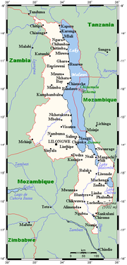
The Republic of Malawi is a landlocked country in southeast Africa that was formerly known as Nyasaland. It is bordered by Zambia to the northwest, Tanzania to the northeast, and Mozambique on the east, south and west. The country is separated from Tanzania and Mozambique by Lake Malawi. Its size...
is situated in southeastern Africa
Africa
Africa is the world's second largest and second most populous continent, after Asia. At about 30.2 million km² including adjacent islands, it covers 6% of the Earth's total surface area and 20.4% of the total land area...
. It is wholly within the tropics; from about 9°30S at its northernmost point to about 17°S at the southernmost tip.
The country occupies a thin strip of land in between Zambia
Zambia
Zambia , officially the Republic of Zambia, is a landlocked country in Southern Africa. The neighbouring countries are the Democratic Republic of the Congo to the north, Tanzania to the north-east, Malawi to the east, Mozambique, Zimbabwe, Botswana and Namibia to the south, and Angola to the west....
and Mozambique
Mozambique
Mozambique, officially the Republic of Mozambique , is a country in southeastern Africa bordered by the Indian Ocean to the east, Tanzania to the north, Malawi and Zambia to the northwest, Zimbabwe to the west and Swaziland and South Africa to the southwest...
protruding southwards into Mozambique along the valley of the Shire River
Shire River
The Shire is a river in Malawi and Mozambique. The river has been known as the Shiré or Chire River. It is the outlet of Lake Malawi and flows into the Zambezi. Its length is 402 km; including Lake Malawi and the Ruhuhu, its headstream, it has a length of about 1200 km...
. In the north and north east it also shares a border with Tanzania
Tanzania
The United Republic of Tanzania is a country in East Africa bordered by Kenya and Uganda to the north, Rwanda, Burundi, and the Democratic Republic of the Congo to the west, and Zambia, Malawi, and Mozambique to the south. The country's eastern borders lie on the Indian Ocean.Tanzania is a state...
.
Malawi is landlocked and is connected by rail to the Mozambican ports of Nacala
Nacala
Nacala, also known as Cidade de Nacala or Nacala-Porto is on the northern coast of Mozambique is the deepest natural port on the east coast of Africa. It serves as the terminal for the Nacala Railway, a rail link to the landlocked Malawi...
and Beira
Beira, Mozambique
Beira is the second largest city in Mozambique. It lies in the central region of the country in Sofala Province, where the Pungue River meets the Indian Ocean. Beira had a population of 412,588 in 1997, which grew to an estimated 546,000 in 2006...
.
Landscape
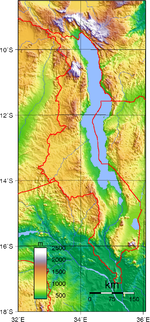
The Great Rift ValleyGreat Rift Valley
The Great Rift Valley is a name given in the late 19th century by British explorer John Walter Gregory to the continuous geographic trench, approximately in length, that runs from northern Syria in Southwest Asia to central Mozambique in South East Africa...
traverses the country from north to south. In this deep trough lies Lake Malawi
Lake Malawi
Lake Malawi , is an African Great Lake and the southernmost lake in the Great Rift Valley system of East Africa. This lake, the third largest in Africa and the eighth largest lake in the world, is located between Malawi, Mozambique, and Tanzania...
, the third-largest lake in Africa, comprising about 20% of Malawi's area. The Shire River
Shire River
The Shire is a river in Malawi and Mozambique. The river has been known as the Shiré or Chire River. It is the outlet of Lake Malawi and flows into the Zambezi. Its length is 402 km; including Lake Malawi and the Ruhuhu, its headstream, it has a length of about 1200 km...
flows from the south end of the lake and joins the Zambezi River 400 kilometres (249 mi) farther south in Mozambique.
West of the Great Rift Valley, the land forms high plateaus, generally between 900 and 1200 m (2,952.8 and 3,937 ft) above sea level. In the north, the Nyika Uplands rise as high as 2600 metres (8,530 ft). The area to the west of the lake in northern and central Malawi has been categorised by the World Wildlife Fund as part of the Central Zambezian Miombo woodlands
Central Zambezian Miombo woodlands
The densely forested Central Zambezian Miombo woodlands that cut across southern central Africa are one of the largest ecozones on the continent and home to a great variety of wildlife including many large mammals.-Location and description:...
ecoregion
Ecoregion
An ecoregion , sometimes called a bioregion, is an ecologically and geographically defined area that is smaller than an ecozone and larger than an ecosystem. Ecoregions cover relatively large areas of land or water, and contain characteristic, geographically distinct assemblages of natural...
.
South of the lake lie the Shire Highlands, with an elevation of 600–1600 m (1,968.5–5,249.3 ft), rising to elevations of 2130 and 3002 m (6,988.2 and 9,849.1 ft) at the Zomba Plateau and Mulanje Massif
Mulanje Massif
The Mulanje Massif, also known as Mount Mulanje, is a large monadnock in southern Malawi near the city of Blantyre, rising sharply from the surrounding plains of Chiradzulu, and the tea-growing Mulanje district...
respectively. In the extreme south, the elevation is only 60–90 m (196.9–295.3 ft) above sea level.
Malawi is one of Sub-Saharan Africa
Sub-Saharan Africa
Sub-Saharan Africa as a geographical term refers to the area of the African continent which lies south of the Sahara. A political definition of Sub-Saharan Africa, instead, covers all African countries which are fully or partially located south of the Sahara...
's most densely populated countries. The population of Lilongwe
Lilongwe
Lilongwe, estimated population 902,388 as of 2009, is the capital and largest city of Malawi. It lies in the country's central region, on the Lilongwe River, near the border of Malawi, Mozambique, and Zambia, and on the main north-south highway of Malawi, the M1.-History:The city started life as a...
—Malawi's capital since 1971—exceeds 400,000. All government ministries and the Parliament are located in Lilongwe. Blantyre, Malawi
Blantyre, Malawi
Blantyre or Mandala is Malawi's centre of finance and commerce, the largest city with an estimated 732,518 inhabitants . It is sometimes referred to as the commercial capital of Malawi as opposed to the political capital, Lilongwe...
remains Malawi's major commercial center and largest city, having grown from an estimated 109,000 inhabitants in 1966 to nearly 500,000 in 1998. Malawi's President resides in Blantyre. The Supreme Court is seated in Blantyre.
Malawi has five national park
National park
A national park is a reserve of natural, semi-natural, or developed land that a sovereign state declares or owns. Although individual nations designate their own national parks differently A national park is a reserve of natural, semi-natural, or developed land that a sovereign state declares or...
s:
- Cape Maclear National Park
- Kasungu National ParkKasungu National ParkKasungu National Park is a national park in Malawi. It is located west of Kasungu, about 175 km north of Lilongwe, extending along the Zambian border....
- Lengwe National ParkLengwe National ParkLengwe National Park is a national park in Malawi....
- Liwonde National ParkLiwonde National ParkLiwonde National Park is a national park in Malawi. It is located on the upper Shire River plain, east of the river, 140 km north of Limbe. Its southern gate lies about 6 km from the town center of Liwonde, and is accessible by bicycle taxi or walking...
- Nyika National ParkNyika National ParkNyika National Park is Malawi’s largest national park, with an area of 3200 km² .-Location and road access:The park covers practically the whole of the Nyika Plateau in northern Malawi, about 480 km north of Lilongwe and 60 km north of Rumphi by road...
Climate
Malawi's climate is generally tropical. A rainy season runs from November to April. There is little to no rainfall throughout much of the country from May to October.It is hot and humid from September to April along the lake and in the lower Shire Valley, with average daytime maxima around 27 to 29 °C (80.6 to 84.2 °F). Lilongwe is also hot and humid during these months, albeit far less than in the south. The rest of the country is warm during those months with a maximum temperature during the day around 25 °C (77 °F). From June through August, the lake areas and south are comfortably warm, with daytime maxima of around 23 °C (73.4 °F), but the rest of Malawi can be chilly at night, with temperatures ranging from 10–14 °C (50–57.2 °F). High altitude areas such as Mulanje and Nyika are often cold at night (around 6–8 °C (42.8–46.4 °F)) during June and July.
Karonga in the far north shows little variation in temperature with maximum daytime temperature remaining around 25 to 26 °C (77 to 78.8 °F) all year round but is unusual in that April and May are the wettest times of the year due to strengthening southerly winds along the lake.
Area
The total area of the country is 118,480 km², but this includes 24,400 km² of water surface, mainly composed of Lake Malawi, but there are other sizeable lakes, such as Lake MalombeLake Malombe
Lake Malombe is a lake in southern part of Malawi, on the Shire River, in the Southern Region. It is located at around . It has an area of about . In recent years the number of fishermen on the lake rose substantially, this led to local decline in some fish species, such as chambo.- References :*...
, Lake Chilwa
Lake Chilwa
Lake Chilwa is the second-largest lake in Malawi after Lake Malawi. It is in eastern Zomba District, near the border with Mozambique. Approximately 60 km long and 40 km wide, the lake is surrounded by extensive wetlands....
and Lake Chiuta
Lake Chiuta
Lake Chiuta is a shallow lake on the border between Malawi and Mozambique. It lies to the north of Lake Chilwa and to the south of Lake Amaramba, which has no outlet, and the lakes are separated by a sandy ridge...
. The land area is 94,080 km².
The country is dominated by Lake Malawi, which drains into the Zambezi River through the Shire River. As a result the whole of the country, except for one eastern district is part of the Zambezi drainage system. Lake Chiuta and the surrounding plain is drained by the Lugenda river, which is part of the Ruvuma River
Ruvuma River
Ruvuma River, formerly also known as the Rovuma River, is a river in East Africa, forming during the greater part of its course the border between Tanzania and Mozambique . It is long, with a drainage basin in size...
drainage system. Lake Chilwa, about 35 km south of Lake Chiuta is unusual as it has no outlet although when it overflows it flows into Lake Chiuta through a swampy plain
Zambezian flooded grasslands
The Zambezian flooded grasslands is an ecoregion of southern and eastern Africa that is rich in wildlife.-Setting:The Zambezian flooded grasslands can be found on seasonally or permanently flooded lowlands in the basin of the Zambezi and neighboring river basins...
. High rates of evaporation ensure that the lake seldom fills up – much of the lake is only 1 metre deep or less.
Environment — current issues:
Deforestation; land degradation; water pollution from agricultural runoff, sewage, industrial wastes; siltation of spawning grounds endangers fish populations
Environment — international agreements:
party to:
Biodiversity, Climate Change, Desertification, Endangered Species, Environmental Modification, Hazardous Wastes, Marine Life Conservation, Nuclear Test Ban, Ozone Layer Protection, Wetlands
signed, but not ratified:
Law of the Sea
Extreme points
This is a list of the extreme points of MalawiMalawi
The Republic of Malawi is a landlocked country in southeast Africa that was formerly known as Nyasaland. It is bordered by Zambia to the northwest, Tanzania to the northeast, and Mozambique on the east, south and west. The country is separated from Tanzania and Mozambique by Lake Malawi. Its size...
, the points that are farther north, south, east or west than any other location.
- Northern-most point - the tripointTripointA tripoint, or trijunction , is a geographical point at which the borders of three countries or subnational entities meet....
with TanzaniaTanzaniaThe United Republic of Tanzania is a country in East Africa bordered by Kenya and Uganda to the north, Rwanda, Burundi, and the Democratic Republic of the Congo to the west, and Zambia, Malawi, and Mozambique to the south. The country's eastern borders lie on the Indian Ocean.Tanzania is a state...
and ZambiaZambiaZambia , officially the Republic of Zambia, is a landlocked country in Southern Africa. The neighbouring countries are the Democratic Republic of the Congo to the north, Tanzania to the north-east, Malawi to the east, Mozambique, Zimbabwe, Botswana and Namibia to the south, and Angola to the west....
, Northern RegionNorthern Region, MalawiThe Northern Region of Malawi, population 1,698,502, covers an area of 26,931 km². Its capital city is Mzuzu. The Northern Region borders Zambia to the west, Tanzania to the north, Lake Malawi to the east, and Malawi's Central Region to its south.... - Eastern-most point - unnamed location on the border with MozambiqueMozambiqueMozambique, officially the Republic of Mozambique , is a country in southeastern Africa bordered by the Indian Ocean to the east, Tanzania to the north, Malawi and Zambia to the northwest, Zimbabwe to the west and Swaziland and South Africa to the southwest...
immediately south-west of the Mozambican village of Buena-uzi, Southern RegionSouthern Region, MalawiThe Southern Region of Malawi, population 5,876,784, covers an area of 31,753 km². Its capital city is Blantyre.Of the 28 districts in Malawi, 12 are located within the Southern Region They are: Balaka, Blantyre, Chikwawa, Chiradzulu, Machinga, Mangochi, Mulanje, Mwanza, Neno, Nsanje,... - Southern-most point - unnamed location on the border with MozambiqueMozambiqueMozambique, officially the Republic of Mozambique , is a country in southeastern Africa bordered by the Indian Ocean to the east, Tanzania to the north, Malawi and Zambia to the northwest, Zimbabwe to the west and Swaziland and South Africa to the southwest...
immediately north-east of the Mozambican village of Jossene, Southern RegionSouthern Region, MalawiThe Southern Region of Malawi, population 5,876,784, covers an area of 31,753 km². Its capital city is Blantyre.Of the 28 districts in Malawi, 12 are located within the Southern Region They are: Balaka, Blantyre, Chikwawa, Chiradzulu, Machinga, Mangochi, Mulanje, Mwanza, Neno, Nsanje,... - Western-most point - unnamed location on the border with ZambiaZambiaZambia , officially the Republic of Zambia, is a landlocked country in Southern Africa. The neighbouring countries are the Democratic Republic of the Congo to the north, Tanzania to the north-east, Malawi to the east, Mozambique, Zimbabwe, Botswana and Namibia to the south, and Angola to the west....
immediately east of the Zambian town of ChipataChipataChipata, population 98,416, is the capital of the Eastern Province of Zambia. The two languages spoken are Nyanja and English, though you might find some Indian languages, as there is a large number of Zambian Indians located in the town...
, Central RegionCentral Region, MalawiThe Central Region of Malawi, population 5,491,034 , covers an area of 35,592 km². Its capital city is Lilongwe, which is also the national capital...
See also
- MalawiMalawiThe Republic of Malawi is a landlocked country in southeast Africa that was formerly known as Nyasaland. It is bordered by Zambia to the northwest, Tanzania to the northeast, and Mozambique on the east, south and west. The country is separated from Tanzania and Mozambique by Lake Malawi. Its size...
- List of ecoregions in Malawi
- List of islands of Malawi