
Geography of Luxembourg
Encyclopedia
Luxembourg
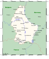
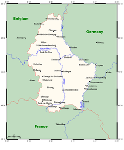
Luxembourg , officially the Grand Duchy of Luxembourg , is a landlocked country in western Europe, bordered by Belgium, France, and Germany. It has two principal regions: the Oesling in the North as part of the Ardennes massif, and the Gutland in the south...
is a small country located in the Low Countries
Low Countries
The Low Countries are the historical lands around the low-lying delta of the Rhine, Scheldt, and Meuse rivers, including the modern countries of Belgium, the Netherlands, Luxembourg and parts of northern France and western Germany....
, part of North-West Europe
North-West Europe
North-West Europe is a term that refers to a northern area of Western Europe, although the exact area or countries it comprises varies.-Geographic definition:...
It borders Belgium
Belgium
Belgium , officially the Kingdom of Belgium, is a federal state in Western Europe. It is a founding member of the European Union and hosts the EU's headquarters, and those of several other major international organisations such as NATO.Belgium is also a member of, or affiliated to, many...
(148 kilometres) to the west and north, France
France
The French Republic , The French Republic , The French Republic , (commonly known as France , is a unitary semi-presidential republic in Western Europe with several overseas territories and islands located on other continents and in the Indian, Pacific, and Atlantic oceans. Metropolitan France...
(73 km) to the south, and Germany
Germany
Germany , officially the Federal Republic of Germany , is a federal parliamentary republic in Europe. The country consists of 16 states while the capital and largest city is Berlin. Germany covers an area of 357,021 km2 and has a largely temperate seasonal climate...
(138 km) to the east. Luxembourg is landlocked, separated from the North Sea
North Sea
In the southwest, beyond the Straits of Dover, the North Sea becomes the English Channel connecting to the Atlantic Ocean. In the east, it connects to the Baltic Sea via the Skagerrak and Kattegat, narrow straits that separate Denmark from Norway and Sweden respectively...
by Belgium.
The topography of the country is divided very clearly between the hilly Oesling
Oesling
The Oesling or Ösling is a region covering the northern part of the Grand Duchy of Luxembourg, within the greater Ardennes area that also covers parts of Belgium and France...
of the northern third of the Grand Duchy and the flat Gutland
Gutland (Luxembourg)
Gutland is a region covering the southern and central parts of the Grand Duchy of Luxembourg. Gutland covers 68% of the territory of Luxembourg; to the north of Gutland lies the Oesling, which covers the remaining 32% of the Grand Duchy....
, which occupies the southern two-thirds. The country's longest river is the Sauer
Sauer
The Sauer or Sûre is a river in Belgium, Luxembourg and Germany. A left tributary of the river Moselle, its total length is 173 km....
, which is a tributary of the Moselle, the basin of which includes almost all of Luxembourg's area. Other major rivers include the Alzette
Alzette
The Alzette is a river with a length of 73 kilometers in France and Luxembourg. It is a right tributary of the Sauer.It rises in Thil near the town Villerupt in the Meurthe-et-Moselle département, France. It crosses the border with Luxembourg after a few kilometres. In Lameschmillen it is joined...
in the south and the Wiltz
Wiltz River
The Wiltz is a river flowing through Belgium and Luxembourg, joining the Sauer at Goebelsmuhle. The Clerve is a tributary of the Wiltz.-External links:...
in the north.
The capital, and by far the largest city, is Luxembourg City, which is located in the Gutland, as are most of the country's main population centres, including Esch-sur-Alzette
Esch-sur-Alzette
Esch-sur-Alzette is a commune with city status, in south-western Luxembourg. It is the country's second city, and its second-most populous commune, with a population of 29,853 people...
, Dudelange
Dudelange
Dudelange is a commune with city status in southern Luxembourg. It is the fourth-most populous commune, with over 18,300 inhabitants. Dudelange is situated close to the border to France....
, and Differdange
Differdange
Differdange is a commune with city status in south-western Luxembourg. Differdange is an industrial city that was home to much of Luxembourg's steel production, and lies near the borders with Belgium and France...
. Besides Luxembourg City, the other main towns are primarily located in the southern Red Lands
Red Lands
The Red Lands form a geographic region in southern and south-western Luxembourg. They are called this way for their red iron-laden earth.The Red Lands roughly correspond with the southern part of the canton of Esch-sur-Alzette, along the border with France...
region, which lines the border between Luxembourg and France to the south.
Topography

Ardennes
The Ardennes is a region of extensive forests, rolling hills and ridges formed within the Givetian Ardennes mountain range, primarily in Belgium and Luxembourg, but stretching into France , and geologically into the Eifel...
, where the mountain heights range from 1,500 to almost 2,000 feet (460–610 m) high. The rest of the country is made up of undulating countryside with broad valleys. The capital, Luxembourg City, is located in the southern part of the country.
Green heart of Europe
The most prominent landmark, the high plateau of the Ardennes in the north, took millions of years to carve. At its highest point, it reaches a height of 1,834 feet (559 m). Commonly known as the Oesling, the Ardennes region covers 325 square miles (841.7 km²), about 32% of the entire country. Rugged scenery predominates because river erosion over thousands of years has left a varied, low mountain landscape, densely covered with vegetation, sometimes with considerable variations in height. These differences in relief, together with stretches of water interspersed with forests, fields, and pastures are the main features that make the landscape so distinctive. Typical of this high area, however, is the infertile soil and poor drainage resulting in numerous peat bogs, which were once exploited as fuel. These factors, combined with heavy rainfall and frost, made this an inhospitable environment for the first settlers.Even today, the living conditions in such an environment are not particularly favourable. Nevertheless, some 7,800 people make a living of the land through either forestry, small-scale farming, or environment work. Because the soil is so difficult to cultivate, most of the land is used for cattle pasture. The Ardennes region also includes the Upper Sûre National Park
Upper Sûre National Park
Upper Sûre National Park is located in the far northwest of the Oesling area of Luxembourg, and is primarily an area of conservation and a specially protected area for wild birds. The objectives of the park are threefold....
, an important conservation area and a hiker's retreat.
South of the Sûre River
Sauer
The Sauer or Sûre is a river in Belgium, Luxembourg and Germany. A left tributary of the river Moselle, its total length is 173 km....
, the country is known as the Gutland
Gutland (Luxembourg)
Gutland is a region covering the southern and central parts of the Grand Duchy of Luxembourg. Gutland covers 68% of the territory of Luxembourg; to the north of Gutland lies the Oesling, which covers the remaining 32% of the Grand Duchy....
. The region covers slightly over two-thirds of the country.
The terrain gently rises and falls with an average height of 700 feet (200 m). Agriculture is the main activity as term Gutland arises from the fertile soil and warm, dry summers experienced is this part of the Duchy compared to the Oesling region.
As a result, vegetables and fruit, such as strawberries, apples, plums, and cherries, are grown in large quantities. River erosion in this area has created deep gorges and caves, resulting in some spectacular scenery.
In the extreme south of the country lies "the land of the red rocks"- a reference to the deposits of minerals found here. Rich in iron ore, the district has been a mining and heavy industrial region since Roman if not earlier times and stretches for over 12 miles (19.3 km). The tall chimneys of the iron and steel works are typical landmarks of the industrial south. To the east lies the grape-growing valley of the Moselle. Numerous villages nestle in the deep valleys and behind the vineyards along the river banks. Most villages have at least one winery. Also in the east is the "Little Switzerland
Little Switzerland (Luxembourg)
Little Switzerland is a nickname for a region in the east of Luxembourg, bestowed upon the region on account of its reputed geographic similarities to Switzerland. It is roughly contiguous with the canton of Echternach...
" area, characterized by wooded glens and ravines in unusual rock formations.
Rivers and lakes
Luxembourg has a number of minor rivers, such as the EischEisch
The Eisch is a river flowing through Belgium and Luxembourg, joining the Alzette on its left in Mersch. It flows through the towns of Eischen, Hobscheid, Septfontaines, and Marienthal....
, the Alzette
Alzette
The Alzette is a river with a length of 73 kilometers in France and Luxembourg. It is a right tributary of the Sauer.It rises in Thil near the town Villerupt in the Meurthe-et-Moselle département, France. It crosses the border with Luxembourg after a few kilometres. In Lameschmillen it is joined...
, and the Pétrusse
Pétrusse
The Pétrusse is a river flowing through Luxembourg, joining the Alzette at Luxembourg City. It flows through the town of Hollerich....
, but the main river is the Moselle with its tributaries-the Sûre and the Our
Our River
The Our is a river of Belgium, Luxembourg and Germany. It is a left tributary to the river Sauer/Sûre. Its total length is 78 km....
. Together, their courses serve as a natural boundary between Luxembourg and Germany
Germany
Germany , officially the Federal Republic of Germany , is a federal parliamentary republic in Europe. The country consists of 16 states while the capital and largest city is Berlin. Germany covers an area of 357,021 km2 and has a largely temperate seasonal climate...
. Along their banks, many of the country's medieval castles can be found.
The Moselle actually rises in northeast France
France
The French Republic , The French Republic , The French Republic , (commonly known as France , is a unitary semi-presidential republic in Western Europe with several overseas territories and islands located on other continents and in the Indian, Pacific, and Atlantic oceans. Metropolitan France...
and flows north through Luxembourg for 19 miles (30.6 km) to join the mighty Rhine at Koblenz
Koblenz
Koblenz is a German city situated on both banks of the Rhine at its confluence with the Moselle, where the Deutsches Eck and its monument are situated.As Koblenz was one of the military posts established by Drusus about 8 BC, the...
, Germany
Germany
Germany , officially the Federal Republic of Germany , is a federal parliamentary republic in Europe. The country consists of 16 states while the capital and largest city is Berlin. Germany covers an area of 357,021 km2 and has a largely temperate seasonal climate...
. The Moselle is 320 miles (515 km) long, and is navigable, due to canalization for 40 miles (64.4 km). Green slopes, covered with vines, flank the meandering course of the river.
Rising in Belgium, the Sûre River flows for 107 miles (172.2 km) in an easterly direction through Luxembourg and into the Moselle. Its sinuous course essentially cuts Luxembourg from east to west. The Our River, flowing along the northeastern border, is a tributary of the Sûre. Its valley is surrounded by unspoiled countryside.
The Upper Sûre lake is the largest stretch of water in the Grand Duchy. Surrounded by luxuriant vegetation and peaceful creeks, the lake is a centre for water sports, such as sailing, canoeing, and kayaking. Such outdoor activities, which has made it an attractive spot for tourists, have led to the growth of a local crafts industry.
The town of Esch-sur-Sûre
Esch-sur-Sûre
Esch-sur-Sûre is a commune and small town in north-western Luxembourg. It is part of the canton of Wiltz, which is part of the district of Diekirch...
nestles at one end of the lake. Immediately above it, the river has been dammed to form a hydroelectric reservoir extending some 6 miles (9.7 km) up the valley. The Upper Sûre dam was built in the 1960s to meet the country's drinking water requirements.
Extreme points
Elevation extremes:lowest point:
Moselle in Wasserbillig
Wasserbillig
Wasserbillig is a town in the commune of Mertert, in eastern Luxembourg. , Wasserbillig has 2,186 inhabitants, which makes it the largest town in Mertert. It lies at the confluence of the rivers Moselle and Sauer, which form the border with Germany at the town...
133 m
highest point:
Kneiff
Kneiff
Kneiff is a hill in the commune of Troisvierges, in northern Luxembourg, near the tripoint shared with Belgium and Germany. At 560 metres, it is the highest point in the country; it is 1 m taller than Buurgplaatz, which is often erroneously considered Luxembourg's highest point. It lies close to...
in Troisvierges
Troisvierges
Troisvierges is a commune and town in northern Luxembourg, in the canton of Clervaux. The two highest hills in Luxembourg, the Kneiff and Buurgplaatz , are located in the commune....
560 m
Climate

Seasonal weather is somewhat different between the northern and southern regions. In the north there is considerable influence from the Atlantic systems, in which the passage of frequent pressure depressions gives rise to unstable weather conditions. This results in overcast skies and considerable drizzle in the winter.
Rainfall reaches 1200 mm (47.2 in) a year in some areas. In the summer, excessive heat is rare and temperatures drop noticeably at night. Low temperatures and humidity make for what those living in this part of the country call, optimistically, an "invigorating climate".
In the south, although the rainfall is not significantly low, at around 800 mm (31.5 in), and the winters no milder, the principal difference is in the higher summer temperatures, especially in the Moselle Valley
Moselle valley
The Moselle valley is a region in north-eastern France, south-western Germany, and eastern Luxembourg, centred on the river valley formed by the Moselle...
. Crops, especially wine grapes, thrive here. With a mean annual temperature of 10 °C (50 °F), the sunniest months are May to August. In the spring, the countryside is a riot of wildflowers and blossoms.
Flora and fauna
Luxembourg's flora is characterized by the country's location at the border between the Atlantic-European and Central-European climate zones. In the north, beechEuropean Beech
Fagus sylvatica, the European Beech or Common Beech, is a deciduous tree belonging to the beech family Fagaceae.-Natural range:...
and oak
Pedunculate Oak
Quercus robur is commonly known as the Pedunculate Oak or English oak. It is native to most of Europe, and to Anatolia to the Caucasus, and also to parts of North Africa.-Taxonomy:Q...
trees are plentiful. The oak trees can grow up to 30 –, with a diameter of 1.2 –. They supply large quantities of excellent hardwood timber because of their strength.
Along the riverbanks, species like the Black Alder and willow
Willow
Willows, sallows, and osiers form the genus Salix, around 400 species of deciduous trees and shrubs, found primarily on moist soils in cold and temperate regions of the Northern Hemisphere...
s can be found. Alder wood is pale yellow to reddish brown, fine-textured and durable even under water. It is also an important timber tree mainly because of its disease-resistant properties. Willow trees can reach a height of 20 m (66 ft), and are valued for ornamental purposes.
The narrow, deeply incised valleys of the north also provide a habitat for rare plants and animals, especially the European Otter
European Otter
The European Otter , also known as the Eurasian otter, Eurasian river otter, common otter and Old World otter, is a European and Asian member of the Lutrinae or otter subfamily, and is typical of freshwater otters....
, a protected species. In the industrial south, among the abandoned quarries and deserted open pit mines, nature has reclaimed her own, and there are flowers everywhere.
International agreements
Party to:Air Pollution, Air Pollution-Nitrogen Oxides, Air Pollution-Sulphur 85, Air Pollution-Sulphur 94, Air Pollution-Volatile Organic Compounds, Biodiversity, Climate Change, Desertification, Endangered Species, Hazardous Wastes, Marine Dumping, Nuclear Test Ban, Ozone Layer Protection, Ship Pollution, Tropical Timber 83, Tropical Timber 94, Wetlands
Signed, but not ratified:
Air Pollution-Persistent Organic Pollutants, Climate Change-Kyoto Protocol, Environmental Modification, Law of the Sea
Geographical statistics
Geographic coordinates:49°45′N 6°10′E
Area:
total:
2 586 km²
land:
2 586 km²
water:
0 km²
Natural resources:
iron ore (no longer exploited), arable land
Land use:
arable land:
42%
permanent crops:
1%
permanent pastures:
20%
forests and woodland:
21%
other:
34%
Irrigated land:
10 km² (including Belgium) (1993 est.)