

Geography of Liberia
Encyclopedia
Liberia
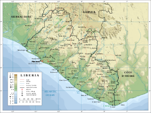
Liberia , officially the Republic of Liberia, is a country in West Africa. It is bordered by Sierra Leone on the west, Guinea on the north and Côte d'Ivoire on the east. Liberia's coastline is composed of mostly mangrove forests while the more sparsely populated inland consists of forests that open...
is a large Sub-Saharan
Sub-Saharan Africa
Sub-Saharan Africa as a geographical term refers to the area of the African continent which lies south of the Sahara. A political definition of Sub-Saharan Africa, instead, covers all African countries which are fully or partially located south of the Sahara...
nation in West Africa located at 6 °N, 9 °W. The country is shaped like a rectangle
Rectangle
In Euclidean plane geometry, a rectangle is any quadrilateral with four right angles. The term "oblong" is occasionally used to refer to a non-square rectangle...
, with a shape similar to El Salvador
El Salvador
El Salvador or simply Salvador is the smallest and the most densely populated country in Central America. The country's capital city and largest city is San Salvador; Santa Ana and San Miguel are also important cultural and commercial centers in the country and in all of Central America...
. It borders the north Atlantic Ocean to the southwest (579 km of coastline) and three other African nations on the other three sides. The total length of Liberia's land border
Border
Borders define geographic boundaries of political entities or legal jurisdictions, such as governments, sovereign states, federated states and other subnational entities. Some borders—such as a state's internal administrative borders, or inter-state borders within the Schengen Area—are open and...
s is 1,587 km: 306 km with Sierra Leone
Sierra Leone
Sierra Leone , officially the Republic of Sierra Leone, is a country in West Africa. It is bordered by Guinea to the north and east, Liberia to the southeast, and the Atlantic Ocean to the west and southwest. Sierra Leone covers a total area of and has an estimated population between 5.4 and 6.4...
on the northwest, 563 km with Guinea
Guinea
Guinea , officially the Republic of Guinea , is a country in West Africa. Formerly known as French Guinea , it is today sometimes called Guinea-Conakry to distinguish it from its neighbour Guinea-Bissau. Guinea is divided into eight administrative regions and subdivided into thirty-three prefectures...
to the north, and 716 km with Côte d'Ivoire
Côte d'Ivoire
The Republic of Côte d'Ivoire or Ivory Coast is a country in West Africa. It has an area of , and borders the countries Liberia, Guinea, Mali, Burkina Faso and Ghana; its southern boundary is along the Gulf of Guinea. The country's population was 15,366,672 in 1998 and was estimated to be...
. In total, Liberia comprises 111,370 km² of which 96,320 km² is land and 15,050 km² is water, making the country slightly smaller than the U.S. state of Washington.
Maritime Claims
Liberia currently claims a territorial sea of 200 nmi (370.4 km; 230.2 mi).Terrain
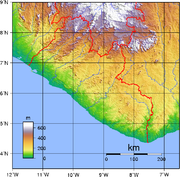
Liberia has a mostly hilly terrain, from rolling plains along the coast to a rolling plateau and low mountains in the northeast.Elevation extremes
The lowest point on Liberia is at sea level on the Atlantic Ocean. The highest point on Liberia is 1 440 meters above sea level at Mount WuteveMount Wuteve
Mount Wuteve is a mountain located in Liberia, whose summit is the highest point in Liberia. It is located in the Guinea Highlands range, whose parent range is the West Africa Mountains. Data from the Shuttle Radar Topography Mission reveals that the correct altitude of its summit is 1,440 meters,...
.
Climate
Liberia has a tropical climateTropical climate
A tropical climate is a climate of the tropics. In the Köppen climate classification it is a non-arid climate in which all twelve months have mean temperatures above...
. This means it is hot and humid throughout much of the year. The seasons are split into dry winters with hot days and cool to cold nights and wet, cloudy summers with frequent and heavy showers.
Natural resources
Natural resourcesNatural Resources
Natural Resources is a soul album released by Motown girl group Martha Reeves and the Vandellas in 1970 on the Gordy label. The album is significant for the Vietnam War ballad "I Should Be Proud" and the slow jam, "Love Guess Who"...
that are found in Liberia include iron ore, timber
Timber
Timber may refer to:* Timber, a term common in the United Kingdom and Australia for wood materials * Timber, Oregon, an unincorporated community in the U.S...
, diamonds, gold
Gold
Gold is a chemical element with the symbol Au and an atomic number of 79. Gold is a dense, soft, shiny, malleable and ductile metal. Pure gold has a bright yellow color and luster traditionally considered attractive, which it maintains without oxidizing in air or water. Chemically, gold is a...
and hydropower.
Land use and agriculture
3.43%
permanent crops:
3%
permanent pastures:
1.98%
other:
94.59% (2005)
Natural hazards
The natural hazard that occurs in Liberia is a dust-laden harmattanHarmattan
The Harmattan is a dry and dusty West African trade wind. It blows south from the Sahara into the Gulf of Guinea between the end of November and the middle of March...
wind that blows from the Sahara
Sahara
The Sahara is the world's second largest desert, after Antarctica. At over , it covers most of Northern Africa, making it almost as large as Europe or the United States. The Sahara stretches from the Red Sea, including parts of the Mediterranean coasts, to the outskirts of the Atlantic Ocean...
(December to March).
Current environmental issues
Current environmental issues include the fact that the tropical rainforest is subject to deforestation; soil erosion; loss of biodiversity and the pollution of coastal waters from oil residue and raw sewage.Environment - international agreements
party to:
Desertification
Desertification
Desertification is the degradation of land in drylands. Caused by a variety of factors, such as climate change and human activities, desertification is one of the most significant global environmental problems.-Definitions:...
, Endangered Species
Endangered species
An endangered species is a population of organisms which is at risk of becoming extinct because it is either few in numbers, or threatened by changing environmental or predation parameters...
, Marine Dumping, Nuclear Test Ban, Ozone Layer Protection, Ship Pollution, Tropical Timber 83, Tropical Timber 94
signed, but not ratified:
Biodiversity
Biodiversity
Biodiversity is the degree of variation of life forms within a given ecosystem, biome, or an entire planet. Biodiversity is a measure of the health of ecosystems. Biodiversity is in part a function of climate. In terrestrial habitats, tropical regions are typically rich whereas polar regions...
, Climate Change
United Nations Framework Convention on Climate Change
The United Nations Framework Convention on Climate Change is an international environmental treaty produced at the United Nations Conference on Environment and Development , informally known as the Earth Summit, held in Rio de Janeiro from June 3 to 14, 1992...
, Environmental Modification, Law of the Sea
Law of the sea
Law of the sea may refer to:* United Nations Convention on the Law of the Sea* Admiralty law* The Custom of the Sea...
, Marine Dumping, Marine Life Conservation
Extreme points
This is a list of the extreme points of Liberia, the points that are farther north, south, east or west than any other location.- Northern-most point – unnamed location on the border with GuineaGuineaGuinea , officially the Republic of Guinea , is a country in West Africa. Formerly known as French Guinea , it is today sometimes called Guinea-Conakry to distinguish it from its neighbour Guinea-Bissau. Guinea is divided into eight administrative regions and subdivided into thirty-three prefectures...
in the Sodia river immediately north of the town of Vonamai, Lofa CountyLofa CountyLofa is a county in the northernmost portion of the West African nation of Liberia. One of 15 counties that comprise the first-level of administrative division in the nation, it has six districts. Voinjama serves as the capital with the area of the county measuring... - Eastern-most point – unnamed headland at the confluenceConfluenceConfluence, in geography, describes the meeting of two or more bodies of water.Confluence may also refer to:* Confluence , a property of term rewriting systems...
of the Cavally riverCavalla RiverThe Cavalla River is a river in West Africa running from north of Mount Nimba in Guinea, through Côte d'Ivoire, to Zwedru in Liberia, and back to the border with Côte d'Ivoire. It ends in the Gulf of Guinea 21 km east of Harper, Liberia...
and the Hana river, River Gee CountyRiver Gee CountyRiver Gee is a county in the southern portion of the West African nation of Liberia. One of 15 counties that comprise the first-level of administrative division in the nation, it has six districts. Fish Town serves as the capital with the area of the county measuring... - Southern-most point – Kablaké headland, Maryland Country
- Western-most point - unnamed headland immediately west of the town of Sewulu at the mouth of the Mano RiverMano RiverThe Mano River is a river in west Africa, it originates in the Guinea Highlands in Liberia and forms part of the Liberia – Sierra Leone border....
, Grand Cape Mount CountyGrand Cape Mount CountyGrand Cape Mount is a county in the northwestern portion of the West African nation of Liberia. One of 15 counties that comprise the first-level of administrative division in the nation, it has five districts. Robertsport serves as the capital with the area of the county measuring...