

Geography of Lesotho
Encyclopedia
Lesotho
is a mountainous, landlocked country located in Southern Africa
. It is an enclave
, completely surrounded by South Africa
. The total length of the country's borders is 909 kilometres (565 mi). Lesotho covers an area of around 30355 square kilometres (11,720 sq mi), of which a negligible percentage is covered with water.
The most notable geographic fact about Lesotho, apart from its status as an enclave, is that it is the only independent state in the world that lies entirely above 1000 metres (3,281 ft) in elevation
. Its lowest point is at 1400 metres (4,593 ft), the highest lowest point of any country. Because of its elevation, the country's climate is cooler than in most other regions at the same latitude
. Its climate zone
can be classified as continental
.
and Vatican City
, both located within Italy
. The total length of the South African border is 909 kilometres (564.8 mi). Lesotho's status as an enclave also means that it is landlocked and largely dependent on South Africa. The nearest major shipping port is Durban
.
, and in the Senqu
river valley; the highlands formed by the Drakensberg
and Maloti
mountain ranges in the east and central parts of the country; and the foothills that form a divide between the lowlands and the highlands. The lowest elevation in the country is at the junction of the Makhaleng
and Orange
(Senqu) rivers (at the South African border), which at 1400 metres (4,593 ft) is the highest lowest point of any country. Lesotho is the only independent state in the world that lies entirely above 1000 metres (3,281 ft) in elevation. The highest point is the peak of the Thabana Ntlenyana
mountain, which reaches an elevation of 3482 metres (11,424 ft). Over 80% of Lesotho lies above 1800 metres (5,906 ft).
Even though very little of Lesotho is covered in water, the rivers that run across the country are an important part of Lesotho's economy. Much of the country's export income comes from water, and much of its power comes from hydroelectricity
. The Orange River
rises in the Drakensberg
mountains in northeastern Lesotho and flows across the entire length of the country before exiting to South Africa at the Mohale's Hoek District
in the southwest. The Caledon River
marks the northwestern part of the border with South Africa. Other rivers include the Malibamatso
, Matsoku and Senqunyane
.
The bedrock of Lesotho belongs to the Karoo Supergroup
, consisting mostly of shale
and sandstone
. Peat
lands can be found in the highlands of Lesotho, most extensively in the mountainous escarpment
near the country's eastern border. The summit of Thabana Ntlenyana is partially encircled by bogs.
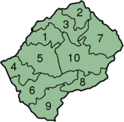
Lesotho is divided into 10 administrative district
s, each with its own capital, called a camptown. The districts are further subdivided into 80 constituencies, which consist of 129 local community councils.
Districts (in alphabetical order):
, with hot summers and cold winters. Maseru
and its surrounding lowlands often reach 30 °C (86 °F) in the summer. Winters can be cold with the lowlands getting down to -7 C and the highlands to -18 C at times.
The yearly precipitation varies from around 600 millimetres (23.6 in) in the lowland valleys to around 1200 millimetres (47.2 in) in areas of the northern and eastern escarpment bordering South Africa. Most of the rain falls as summer thunderstorm
s: 85% of the annual precipitation falls between the months of October and April. The winters—between May and September—are usually relatively dry. Snow
is common in the deserts and low valleys between May and September; the higher peaks can experience snowfall year-round. There is much yearly variance in the amounts of rainfall, which leads to periodic drought
s.
 Lesotho is poor in natural resources. Economically the most important resource is water. The Lesotho Highlands Water Project
allows exporting water from the Malibamatso
, Matsoku, Senqu
and Senqunyane
rivers to South Africa, while also generating hydroelectric power for Lesotho's needs. As of April 2008, the first phase of the project has been completed. The project already accounts for an estimated five percent of Lesotho's GDP
, and when fully completed, it could account for as much as 20 percent.
The main mineral resource is diamonds from the Letseng diamond mine
in the Maluti mountain range. The mine produces very few stones, but has the highest dollar ratio per carat of any diamond mine in the world. Other mineral resources include coal
, galena
, quartz
, agate
and uranium
deposits, but their exploitation is not considered commercially viable. Clay
deposits can be found in the country, and are used for producing tiles, bricks and other ceramics.
Much of the population engages in subsistence farming
, even though only 10.71% of the country's surface is classified as arable land and 0.13% has permanent crops. Much of the land has been ruined by soil erosion. The most fertile farmlands are in the northern and central lowlands, and in the foothills between the lowlands and the mountains. Large tracts of the fertile farmland to the north of the country—in the Free State
region of South Africa—were lost to European colonists in wars during the 19th century.
, the points that are farther north, south, east or west than any other location.
Lesotho
Lesotho , officially the Kingdom of Lesotho, is a landlocked country and enclave, surrounded by the Republic of South Africa. It is just over in size with a population of approximately 2,067,000. Its capital and largest city is Maseru. Lesotho is a member of the Commonwealth of Nations. The name...
is a mountainous, landlocked country located in Southern Africa
Southern Africa
Southern Africa is the southernmost region of the African continent, variably defined by geography or geopolitics. Within the region are numerous territories, including the Republic of South Africa ; nowadays, the simpler term South Africa is generally reserved for the country in English.-UN...
. It is an enclave
Enclave and exclave
In political geography, an enclave is a territory whose geographical boundaries lie entirely within the boundaries of another territory.An exclave, on the other hand, is a territory legally or politically attached to another territory with which it is not physically contiguous.These are two...
, completely surrounded by South Africa
South Africa
The Republic of South Africa is a country in southern Africa. Located at the southern tip of Africa, it is divided into nine provinces, with of coastline on the Atlantic and Indian oceans...
. The total length of the country's borders is 909 kilometres (565 mi). Lesotho covers an area of around 30355 square kilometres (11,720 sq mi), of which a negligible percentage is covered with water.
The most notable geographic fact about Lesotho, apart from its status as an enclave, is that it is the only independent state in the world that lies entirely above 1000 metres (3,281 ft) in elevation
Elevation
The elevation of a geographic location is its height above a fixed reference point, most commonly a reference geoid, a mathematical model of the Earth's sea level as an equipotential gravitational surface ....
. Its lowest point is at 1400 metres (4,593 ft), the highest lowest point of any country. Because of its elevation, the country's climate is cooler than in most other regions at the same latitude
Latitude
In geography, the latitude of a location on the Earth is the angular distance of that location south or north of the Equator. The latitude is an angle, and is usually measured in degrees . The equator has a latitude of 0°, the North pole has a latitude of 90° north , and the South pole has a...
. Its climate zone
Köppen climate classification
The Köppen climate classification is one of the most widely used climate classification systems. It was first published by Crimea German climatologist Wladimir Köppen in 1884, with several later modifications by Köppen himself, notably in 1918 and 1936...
can be classified as continental
Continental climate
Continental climate is a climate characterized by important annual variation in temperature due to the lack of significant bodies of water nearby...
.
Location
Lesotho is a country in Southern Africa, located at around 29°30' south latitude and 28°30' east longitude. It is the 141st largest country in the world, with a total land area of 30355 square kilometres (11,720 sq mi), of which a negligible percentage is covered with water. Lesotho is completely surrounded by South Africa, making it one of only three countries in the world that are enclaves within another country; the other two are San MarinoSan Marino
San Marino, officially the Republic of San Marino , is a state situated on the Italian Peninsula on the eastern side of the Apennine Mountains. It is an enclave surrounded by Italy. Its size is just over with an estimated population of over 30,000. Its capital is the City of San Marino...
and Vatican City
Vatican City
Vatican City , or Vatican City State, in Italian officially Stato della Città del Vaticano , which translates literally as State of the City of the Vatican, is a landlocked sovereign city-state whose territory consists of a walled enclave within the city of Rome, Italy. It has an area of...
, both located within Italy
Italy
Italy , officially the Italian Republic languages]] under the European Charter for Regional or Minority Languages. In each of these, Italy's official name is as follows:;;;;;;;;), is a unitary parliamentary republic in South-Central Europe. To the north it borders France, Switzerland, Austria and...
. The total length of the South African border is 909 kilometres (564.8 mi). Lesotho's status as an enclave also means that it is landlocked and largely dependent on South Africa. The nearest major shipping port is Durban
Durban
Durban is the largest city in the South African province of KwaZulu-Natal and the third largest city in South Africa. It forms part of the eThekwini metropolitan municipality. Durban is famous for being the busiest port in South Africa. It is also seen as one of the major centres of tourism...
.
Physical geography
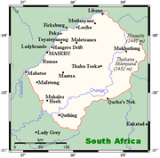
Lesotho can be roughly divided into three geographic regions: the lowlands, following the southern banks of the Caledon RiverCaledon River
The Caledon River is located in south-east Africa, rising in the Drakensberg Mountains in Lesotho. Origin in the former bantustan of QwaQwa, near the border with Lesotho, southwest of Witsieshoek. It then flows south-west, marking the border with South Africa and Lesotho before entering South...
, and in the Senqu
Senqu River
The Senqu River is a river located in the rural highlands in the district of Mokhotlong in the country of Lesotho in Southern Africa. Its tributaries include the Senqunyane River.-Wild life:...
river valley; the highlands formed by the Drakensberg
Drakensberg
The Drakensberg is the highest mountain range in Southern Africa, rising to in height. In Zulu, it is referred to as uKhahlamba , and in Sesotho as Maluti...
and Maloti
Maloti Mountains
The Maloti Mountains , are a mountain range found in the highlands of Lesotho and named the Drakensberg in South Africa. They form a high alpine basalt plateau up to 3400m in height. The highest point is Thabana Ntlenyana 3482m in the north-east...
mountain ranges in the east and central parts of the country; and the foothills that form a divide between the lowlands and the highlands. The lowest elevation in the country is at the junction of the Makhaleng
Makhaleng River
The Makhaleng River is a river of western Lesotho. The river flows southwest from the Maluti Mountains past the towns and villages of Molimo-Nthuse, Makhaleng, Ramabanta and Qaba, flowing into the Orange River at the international border...
and Orange
Orange River
The Orange River , Gariep River, Groote River or Senqu River is the longest river in South Africa. It rises in the Drakensberg mountains in Lesotho, flowing westwards through South Africa to the Atlantic Ocean...
(Senqu) rivers (at the South African border), which at 1400 metres (4,593 ft) is the highest lowest point of any country. Lesotho is the only independent state in the world that lies entirely above 1000 metres (3,281 ft) in elevation. The highest point is the peak of the Thabana Ntlenyana
Thabana Ntlenyana
Thabana Ntlenyana, which literally means "Beautiful little mountain" in Sesotho, is the highest point in Lesotho and the highest mountain in southern Africa. It is situated on the ridge of the Drakensberg mountains near Sani Pass.-External links:* *...
mountain, which reaches an elevation of 3482 metres (11,424 ft). Over 80% of Lesotho lies above 1800 metres (5,906 ft).
Even though very little of Lesotho is covered in water, the rivers that run across the country are an important part of Lesotho's economy. Much of the country's export income comes from water, and much of its power comes from hydroelectricity
Hydroelectricity
Hydroelectricity is the term referring to electricity generated by hydropower; the production of electrical power through the use of the gravitational force of falling or flowing water. It is the most widely used form of renewable energy...
. The Orange River
Orange River
The Orange River , Gariep River, Groote River or Senqu River is the longest river in South Africa. It rises in the Drakensberg mountains in Lesotho, flowing westwards through South Africa to the Atlantic Ocean...
rises in the Drakensberg
Drakensberg
The Drakensberg is the highest mountain range in Southern Africa, rising to in height. In Zulu, it is referred to as uKhahlamba , and in Sesotho as Maluti...
mountains in northeastern Lesotho and flows across the entire length of the country before exiting to South Africa at the Mohale's Hoek District
Mohale's Hoek District
Mohale's Hoek is a district of Lesotho. It has an area of 3,530 km² and a population in 2006 of approximately 174,924. Mohale's Hoek is the capital city or camptown, and only town in the district.-Geography:...
in the southwest. The Caledon River
Caledon River
The Caledon River is located in south-east Africa, rising in the Drakensberg Mountains in Lesotho. Origin in the former bantustan of QwaQwa, near the border with Lesotho, southwest of Witsieshoek. It then flows south-west, marking the border with South Africa and Lesotho before entering South...
marks the northwestern part of the border with South Africa. Other rivers include the Malibamatso
Malibamat'so River
The Malibamat'so River is a river in northern Lesotho. It flows south from close to the South African border, past the town of Ha Lejone, and joins the Senqu River close to the town of Taung. The waters of the Malibamat'so River are dammed by the Katse Dam, the continent's highest ....
, Matsoku and Senqunyane
Senqunyane River
The Senqunyane River is a river of central Lesotho. rises in the Maluti Mountains in the country's northwest, flowing south for 120 kilometres before joining the Senqu River in the country's southwest.-References:...
.
The bedrock of Lesotho belongs to the Karoo Supergroup
Karoo Supergroup
The Karoo Supergroup is the largest stratigraphic unit in Southern Africa, covering almost two thirds of the present land surface, including central Cape Province, almost all of Orange Free State, western Natal, much of south-east Transvaal, Zambia, Zimbabwe and Malawi...
, consisting mostly of shale
Shale
Shale is a fine-grained, clastic sedimentary rock composed of mud that is a mix of flakes of clay minerals and tiny fragments of other minerals, especially quartz and calcite. The ratio of clay to other minerals is variable. Shale is characterized by breaks along thin laminae or parallel layering...
and sandstone
Sandstone
Sandstone is a sedimentary rock composed mainly of sand-sized minerals or rock grains.Most sandstone is composed of quartz and/or feldspar because these are the most common minerals in the Earth's crust. Like sand, sandstone may be any colour, but the most common colours are tan, brown, yellow,...
. Peat
Peat
Peat is an accumulation of partially decayed vegetation matter or histosol. Peat forms in wetland bogs, moors, muskegs, pocosins, mires, and peat swamp forests. Peat is harvested as an important source of fuel in certain parts of the world...
lands can be found in the highlands of Lesotho, most extensively in the mountainous escarpment
Escarpment
An escarpment is a steep slope or long cliff that occurs from erosion or faulting and separates two relatively level areas of differing elevations.-Description and variants:...
near the country's eastern border. The summit of Thabana Ntlenyana is partially encircled by bogs.
Political geography
Lesotho is divided into 10 administrative district
District
Districts are a type of administrative division, in some countries managed by a local government. They vary greatly in size, spanning entire regions or counties, several municipalities, or subdivisions of municipalities.-Austria:...
s, each with its own capital, called a camptown. The districts are further subdivided into 80 constituencies, which consist of 129 local community councils.
Districts (in alphabetical order):
- BereaBerea District-References:...
- Butha-ButheButha-Buthe DistrictButha-Buthe is a district of Lesotho. It has an area of 1,767 km² and a population in 2006 of approximately 109,529. Butha-Buthe is the capital or camptown, and only town in the district.-Geography:...
- LeribeLeribe DistrictLeribè is a district of Lesotho. It has an area of 2,828 km² and a population in 2006 of approximately 298,352. Hlotse is the capital or camptown of the district. The district has one additional town, namely Maputsoe and Matukeng.-Geography:...
- MafetengMafeteng DistrictMafeteng is a district of Lesotho. It has an area of 2,119 km² and a population in 2006 of approximately 193,682. Mafeteng is the capital or camptown, and only town in the district.-Geography:...
- MaseruMaseru DistrictMaseru is a district of Lesotho. It has an area of 4,279 km² and a population in 2006 of approximately 429,823. Maseru is also the name of the district's capital, and is the only city in the district. Additionally it is the capital of the country. It is the largest urban area in the country,...
- Mohale's HoekMohale's Hoek DistrictMohale's Hoek is a district of Lesotho. It has an area of 3,530 km² and a population in 2006 of approximately 174,924. Mohale's Hoek is the capital city or camptown, and only town in the district.-Geography:...
- MokhotlongMokhotlong DistrictMokhotlong district is a district of Lesotho. It includes the highest terrain in the Maloti Range and the source of the Senqu River, Lesotho’s primary watershed. It has an area of 4,075 km² and a population in 2006 of approximately 96,340. It is one of the poorest and most remote areas of...
- Qacha's NekQacha's Nek DistrictQacha's Nek is a district of Lesotho. It has an area of 2,349 km² and a population in 2006 of approximately 71,876. Qacha's Nek is the capital or camptown, and only town in the district.-Geography:...
- QuthingQuthing DistrictQuthing is a district of Lesotho. It has an area of 2,916 km² and a population in 2006 of approximately 120,502. Quthing, also known as Moyeni, is the capital of the district or camptown, and the only town in the district...
- Thaba-TsekaThaba-Tseka DistrictThaba-Tseka is a district of Lesotho. It has an area of 4,270 km² and a population in 2006 of approximately 129,137. Thaba-Tseka is also the name of the district's capital or camptown, which is the only town in the district.-Geography:...
Climate
Because of its altitude, the country remains cooler throughout the year than most other regions at the same latitude. Lesotho has a continental climateContinental climate
Continental climate is a climate characterized by important annual variation in temperature due to the lack of significant bodies of water nearby...
, with hot summers and cold winters. Maseru
Maseru
Maseru is the capital of Lesotho. It is also the capital of the Maseru District. Located on the Caledon River, bordering South Africa, Maseru is Lesotho's only sizable city, with a population of approximately 227,880 . The city was established as a police camp and assigned as the capital after the...
and its surrounding lowlands often reach 30 °C (86 °F) in the summer. Winters can be cold with the lowlands getting down to -7 C and the highlands to -18 C at times.
The yearly precipitation varies from around 600 millimetres (23.6 in) in the lowland valleys to around 1200 millimetres (47.2 in) in areas of the northern and eastern escarpment bordering South Africa. Most of the rain falls as summer thunderstorm
Thunderstorm
A thunderstorm, also known as an electrical storm, a lightning storm, thundershower or simply a storm is a form of weather characterized by the presence of lightning and its acoustic effect on the Earth's atmosphere known as thunder. The meteorologically assigned cloud type associated with the...
s: 85% of the annual precipitation falls between the months of October and April. The winters—between May and September—are usually relatively dry. Snow
Snow
Snow is a form of precipitation within the Earth's atmosphere in the form of crystalline water ice, consisting of a multitude of snowflakes that fall from clouds. Since snow is composed of small ice particles, it is a granular material. It has an open and therefore soft structure, unless packed by...
is common in the deserts and low valleys between May and September; the higher peaks can experience snowfall year-round. There is much yearly variance in the amounts of rainfall, which leads to periodic drought
Drought
A drought is an extended period of months or years when a region notes a deficiency in its water supply. Generally, this occurs when a region receives consistently below average precipitation. It can have a substantial impact on the ecosystem and agriculture of the affected region...
s.
Natural resources
Lesotho Highlands Water Project
The Lesotho Highlands Water Project is an ongoing water supply project with a hydropower component, developed in partnership between the governments of Lesotho and South Africa. It comprises a system of several large dams and tunnels throughout Lesotho and South Africa. In Lesotho, it involves the...
allows exporting water from the Malibamatso
Malibamat'so River
The Malibamat'so River is a river in northern Lesotho. It flows south from close to the South African border, past the town of Ha Lejone, and joins the Senqu River close to the town of Taung. The waters of the Malibamat'so River are dammed by the Katse Dam, the continent's highest ....
, Matsoku, Senqu
Senqu River
The Senqu River is a river located in the rural highlands in the district of Mokhotlong in the country of Lesotho in Southern Africa. Its tributaries include the Senqunyane River.-Wild life:...
and Senqunyane
Senqunyane River
The Senqunyane River is a river of central Lesotho. rises in the Maluti Mountains in the country's northwest, flowing south for 120 kilometres before joining the Senqu River in the country's southwest.-References:...
rivers to South Africa, while also generating hydroelectric power for Lesotho's needs. As of April 2008, the first phase of the project has been completed. The project already accounts for an estimated five percent of Lesotho's GDP
Gross domestic product
Gross domestic product refers to the market value of all final goods and services produced within a country in a given period. GDP per capita is often considered an indicator of a country's standard of living....
, and when fully completed, it could account for as much as 20 percent.
The main mineral resource is diamonds from the Letseng diamond mine
Letseng diamond mine
The Letseng diamond mine, found in the landlocked Southern African kingdom of Lesotho, is owned by Gem Diamonds, Ltd. and the government of Lesotho, and at an elevation of 3,100 m it is the world's highest diamond mine.- Production :...
in the Maluti mountain range. The mine produces very few stones, but has the highest dollar ratio per carat of any diamond mine in the world. Other mineral resources include coal
Coal
Coal is a combustible black or brownish-black sedimentary rock usually occurring in rock strata in layers or veins called coal beds or coal seams. The harder forms, such as anthracite coal, can be regarded as metamorphic rock because of later exposure to elevated temperature and pressure...
, galena
Galena
Galena is the natural mineral form of lead sulfide. It is the most important lead ore mineral.Galena is one of the most abundant and widely distributed sulfide minerals. It crystallizes in the cubic crystal system often showing octahedral forms...
, quartz
Quartz
Quartz is the second-most-abundant mineral in the Earth's continental crust, after feldspar. It is made up of a continuous framework of SiO4 silicon–oxygen tetrahedra, with each oxygen being shared between two tetrahedra, giving an overall formula SiO2. There are many different varieties of quartz,...
, agate
Agate
Agate is a microcrystalline variety of silica, chiefly chalcedony, characterised by its fineness of grain and brightness of color. Although agates may be found in various kinds of rock, they are classically associated with volcanic rocks and can be common in certain metamorphic rocks.-Etymology...
and uranium
Uranium
Uranium is a silvery-white metallic chemical element in the actinide series of the periodic table, with atomic number 92. It is assigned the chemical symbol U. A uranium atom has 92 protons and 92 electrons, of which 6 are valence electrons...
deposits, but their exploitation is not considered commercially viable. Clay
Clay
Clay is a general term including many combinations of one or more clay minerals with traces of metal oxides and organic matter. Geologic clay deposits are mostly composed of phyllosilicate minerals containing variable amounts of water trapped in the mineral structure.- Formation :Clay minerals...
deposits can be found in the country, and are used for producing tiles, bricks and other ceramics.
Much of the population engages in subsistence farming
Subsistence agriculture
Subsistence agriculture is self-sufficiency farming in which the farmers focus on growing enough food to feed their families. The typical subsistence farm has a range of crops and animals needed by the family to eat and clothe themselves during the year. Planting decisions are made with an eye...
, even though only 10.71% of the country's surface is classified as arable land and 0.13% has permanent crops. Much of the land has been ruined by soil erosion. The most fertile farmlands are in the northern and central lowlands, and in the foothills between the lowlands and the mountains. Large tracts of the fertile farmland to the north of the country—in the Free State
Free State
The Free State is a province of South Africa. Its capital is Bloemfontein, which is also South Africa's judicial capital. Its historical origins lie in the Orange Free State Boer republic and later Orange Free State Province. The current borders of the province date from 1994 when the Bantustans...
region of South Africa—were lost to European colonists in wars during the 19th century.
Extreme points
This is a list of the extreme points of LesothoLesotho
Lesotho , officially the Kingdom of Lesotho, is a landlocked country and enclave, surrounded by the Republic of South Africa. It is just over in size with a population of approximately 2,067,000. Its capital and largest city is Maseru. Lesotho is a member of the Commonwealth of Nations. The name...
, the points that are farther north, south, east or west than any other location.
- Northernmost point - unnamed location on the border with Golden Gate National Park in South AfricaSouth AfricaThe Republic of South Africa is a country in southern Africa. Located at the southern tip of Africa, it is divided into nine provinces, with of coastline on the Atlantic and Indian oceans...
immediately north-west of the village of Monontsa,In Butha-Buthe DistrictButha-Buthe DistrictButha-Buthe is a district of Lesotho. It has an area of 1,767 km² and a population in 2006 of approximately 109,529. Butha-Buthe is the capital or camptown, and only town in the district.-Geography:... - Easternmost point - unnamed location on the border with South AfricaSouth AfricaThe Republic of South Africa is a country in southern Africa. Located at the southern tip of Africa, it is divided into nine provinces, with of coastline on the Atlantic and Indian oceans...
immediately west of the South African mountain Giant's CastleGiant's CastleGiant's Castle is a mountain peak in the southern African Drakensberg in KwaZulu Natal. Giants Castle offers visitors to the regions hiking opportunities with panoramic views. The Nature Reserve offers secluded accommodation, bushman rock art with easy access for everyone and about the best base to...
, Mokhotlong DistrictMokhotlong DistrictMokhotlong district is a district of Lesotho. It includes the highest terrain in the Maloti Range and the source of the Senqu River, Lesotho’s primary watershed. It has an area of 4,075 km² and a population in 2006 of approximately 96,340. It is one of the poorest and most remote areas of... - Southernmost point - Gairntoul mountain, Quthing DistrictQuthing DistrictQuthing is a district of Lesotho. It has an area of 2,916 km² and a population in 2006 of approximately 120,502. Quthing, also known as Moyeni, is the capital of the district or camptown, and the only town in the district...
- Westernmost point - unnamed location in the Caledon RiverCaledon RiverThe Caledon River is located in south-east Africa, rising in the Drakensberg Mountains in Lesotho. Origin in the former bantustan of QwaQwa, near the border with Lesotho, southwest of Witsieshoek. It then flows south-west, marking the border with South Africa and Lesotho before entering South...
on the border with South AfricaSouth AfricaThe Republic of South Africa is a country in southern Africa. Located at the southern tip of Africa, it is divided into nine provinces, with of coastline on the Atlantic and Indian oceans...
, Mafeteng DistrictMafeteng DistrictMafeteng is a district of Lesotho. It has an area of 2,119 km² and a population in 2006 of approximately 193,682. Mafeteng is the capital or camptown, and only town in the district.-Geography:...