

Geography of Kiribati
Encyclopedia
Geography
Geography is the science that studies the lands, features, inhabitants, and phenomena of Earth. A literal translation would be "to describe or write about the Earth". The first person to use the word "geography" was Eratosthenes...
of the Republic of Kiribati
Kiribati
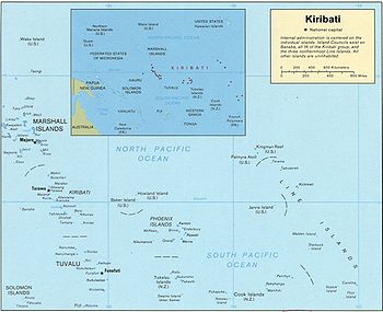
Kiribati , officially the Republic of Kiribati, is an island nation located in the central tropical Pacific Ocean. The permanent population exceeds just over 100,000 , and is composed of 32 atolls and one raised coral island, dispersed over 3.5 million square kilometres, straddling the...
. Kiribati consists of 32 atolls and one island scattered over all four hemispheres in an expanse of ocean equivalent in size to the continental United States. The islands lie roughly halfway between Hawaii
Hawaii
Hawaii is the newest of the 50 U.S. states , and is the only U.S. state made up entirely of islands. It is the northernmost island group in Polynesia, occupying most of an archipelago in the central Pacific Ocean, southwest of the continental United States, southeast of Japan, and northeast of...
and Australia
Australia
Australia , officially the Commonwealth of Australia, is a country in the Southern Hemisphere comprising the mainland of the Australian continent, the island of Tasmania, and numerous smaller islands in the Indian and Pacific Oceans. It is the world's sixth-largest country by total area...
in the Micronesia
Micronesia
Micronesia is a subregion of Oceania, comprising thousands of small islands in the western Pacific Ocean. It is distinct from Melanesia to the south, and Polynesia to the east. The Philippines lie to the west, and Indonesia to the southwest....
n region of the South Pacific. The three main island groupings are the Gilbert Islands
Gilbert Islands
The Gilbert Islands are a chain of sixteen atolls and coral islands in the Pacific Ocean. They are the main part of Republic of Kiribati and include Tarawa, the site of the country's capital and residence of almost half of the population.-Geography:The atolls and islands of the Gilbert Islands...
, Phoenix Islands
Phoenix Islands
The Phoenix Islands are a group of eight atolls and two submerged coral reefs, lying in the central Pacific Ocean east of the Gilbert Islands and west of the Line Islands. They are a part of the Republic of Kiribati. During the late 1930s they became the site of the last attempted colonial...
, and Line Islands
Line Islands
The Line Islands, Teraina Islands or Equatorial Islands, is a chain of eleven atolls and low coral islands in the central Pacific Ocean, south of the Hawaiian Islands, that stretches for 2,350 km in a northwest-southeast direction, making it one of the longest islands chains of the world...
. On 1 January 1995 Kiribati moved the International Date Line
International Date Line
The International Date Line is a generally north-south imaginary line on the surface of the Earth, passing through the middle of the Pacific Ocean, that designates the place where each calendar day begins...
to include its easternmost islands and make it the same day throughout the country.
Kiribati includes Kiritimati
Kiritimati
Kiritimati or Christmas Island is a Pacific Ocean raised coral atoll in the northern Line Islands, and part of the Republic of Kiribati....
(Christmas Atoll; in the Line Islands), the largest coral atoll (in terms of land area, not dimensions) in the world, and Banaba
Banaba Island
Banaba Island , an island in the Pacific Ocean, is a solitary raised coral island west of the Gilbert Island chain and 300 km east of Nauru. It is part of the Republic of Kiribati. It has an area of 6.5 km², and the highest point on the island is also the highest point in Kiribati, at 81...
(Ocean Island), one of the three great phosphate rock islands in the Pacific.
Most of the land on these islands is less than two metres above sea level. A 1989 United Nations
United Nations
The United Nations is an international organization whose stated aims are facilitating cooperation in international law, international security, economic development, social progress, human rights, and achievement of world peace...
report identified Kiribati as one of the countries that could completely disappear in the 21st century if steps are not taken to address global climate change.
Owing to a population growth rate of more than 2% and the overcrowding around the capital of South Tarawa
South Tarawa
South Tarawa is the official capital of the Republic of Kiribati on Tarawa Atoll. The meaning of Teinainano is "down of the mast", alluding to the sail-shape of the atoll...
, a program of migration was begun in 1989 to move nearly 5,000 inhabitants to outlying atolls, mainly in the Line Islands. A program of resettlement to the mostly uninhabited Phoenix Islands was begun in 1995.
Statistics
Location:- Oceania, group of islands in the Pacific Ocean, straddling the equator, about one-half of the way from Hawaii to Australia; note - on 1 January 1995, Kiribati unilaterally moved the International Date Line from the middle of the country to include its easternmost islands and make it the same day throughout the country
Geographic coordinates:
- 1°25′N 173°00′E
Map references:
- Oceania
Area:
- Total: 717 km² (276.8 sq mi)
- Land: 717 km2
- Water: none
- Note: includes three island groups - Gilbert IslandsGilbert IslandsThe Gilbert Islands are a chain of sixteen atolls and coral islands in the Pacific Ocean. They are the main part of Republic of Kiribati and include Tarawa, the site of the country's capital and residence of almost half of the population.-Geography:The atolls and islands of the Gilbert Islands...
, Line IslandsLine IslandsThe Line Islands, Teraina Islands or Equatorial Islands, is a chain of eleven atolls and low coral islands in the central Pacific Ocean, south of the Hawaiian Islands, that stretches for 2,350 km in a northwest-southeast direction, making it one of the longest islands chains of the world...
, Phoenix IslandsPhoenix IslandsThe Phoenix Islands are a group of eight atolls and two submerged coral reefs, lying in the central Pacific Ocean east of the Gilbert Islands and west of the Line Islands. They are a part of the Republic of Kiribati. During the late 1930s they became the site of the last attempted colonial...
Land boundaries:
- none
Coastline:
- 1143 km (710.2 mi)
Maritime claims:
- Exclusive economic zone: 200 nmi (370.4 km)
- Territorial sea: 12 nmi (22.2 km)
Climate:
- Tropical; marine, hot and humid, moderated by trade winds
Terrain:
- Mostly low-lying coral atolls surrounded by extensive reefs
Elevation extremes:
- Lowest point: Pacific OceanPacific OceanThe Pacific Ocean is the largest of the Earth's oceanic divisions. It extends from the Arctic in the north to the Southern Ocean in the south, bounded by Asia and Australia in the west, and the Americas in the east.At 165.2 million square kilometres in area, this largest division of the World...
0 m - Highest point: unnamed location on Banaba 81 m (265.7 ft)
Natural resources:
- Phosphate (production discontinued in 1979)
Land use:
- Arable land: 0%
- Permanent crops: 51%
- Permanent pastures: 0%
- Forests and woodland: 3%
- Other: 46% (1993 est.)
Irrigated land:
Natural hazards:
- Typhoons can occur any time, but usually November to March; occasional tornadoes; low-level of some of the islands make them very sensitive to sea-level rise
Environment - current issues:
- Heavy pollution in lagoon of south Tarawa atoll due to heavy migration mixed with traditional practices such as lagoon latrines and open-pit dumping; ground water at risk
Environment - international agreements:
- Party to: Biodiversity, Climate Change, Desertification, Endangered Species, Law of the SeaLaw of the seaLaw of the sea may refer to:* United Nations Convention on the Law of the Sea* Admiralty law* The Custom of the Sea...
, Marine Dumping, Ozone Layer Protection - Signed, but not ratified: None of the selected agreements
Geography - note:
- 20 of the 33 islands are inhabited; Banaba (Ocean Island) in Kiribati is one of the three great phosphate rock islands in the Pacific Ocean - the others are MakateaMakateaMakatea, or Mangaia-te-vai-tamae, is a raised coral atoll in the northwestern part of the Tuamotus. It is located 79 km southwest from Rangiroa to the west of the Palliser group. It is surrounded by spectacular cliffs, rising to a plateau 80 meters above the sea level. This island is...
in French PolynesiaFrench PolynesiaFrench Polynesia is an overseas country of the French Republic . It is made up of several groups of Polynesian islands, the most famous island being Tahiti in the Society Islands group, which is also the most populous island and the seat of the capital of the territory...
, and NauruNauruNauru , officially the Republic of Nauru and formerly known as Pleasant Island, is an island country in Micronesia in the South Pacific. Its nearest neighbour is Banaba Island in Kiribati, to the east. Nauru is the world's smallest republic, covering just...
.
Extreme points
This is a list of the extreme points of KiribatiKiribati
Kiribati , officially the Republic of Kiribati, is an island nation located in the central tropical Pacific Ocean. The permanent population exceeds just over 100,000 , and is composed of 32 atolls and one raised coral island, dispersed over 3.5 million square kilometres, straddling the...
, the points that are farther north, south, east or west than any other location.
- Northern-most point – TerainaTerainaTeraina, also known as Washington Island is a coral atoll in the central Pacific Ocean and part of the Northern Line Islands which belongs to Kiribati. Obsolete names of Teraina are Prospect Island and New York Island. The island is located approximately 4.71° North latitude and 160.76° West...
(Washington Island), Line IslandsLine IslandsThe Line Islands, Teraina Islands or Equatorial Islands, is a chain of eleven atolls and low coral islands in the central Pacific Ocean, south of the Hawaiian Islands, that stretches for 2,350 km in a northwest-southeast direction, making it one of the longest islands chains of the world... - Eastern-most point – Caroline IslandCaroline IslandCaroline Island or Caroline Atoll , is the easternmost of the uninhabited coral atolls which comprise the southern Line Islands in the central Pacific Ocean....
, Line IslandsLine IslandsThe Line Islands, Teraina Islands or Equatorial Islands, is a chain of eleven atolls and low coral islands in the central Pacific Ocean, south of the Hawaiian Islands, that stretches for 2,350 km in a northwest-southeast direction, making it one of the longest islands chains of the world... - Southern-most point – Flint IslandFlint IslandFlint Island is an uninhabited coral atoll in the central Pacific Ocean, part of the Southern Line Islands under the jurisdiction of Kiribati.-Geography:...
, Line IslandsLine IslandsThe Line Islands, Teraina Islands or Equatorial Islands, is a chain of eleven atolls and low coral islands in the central Pacific Ocean, south of the Hawaiian Islands, that stretches for 2,350 km in a northwest-southeast direction, making it one of the longest islands chains of the world... - Western-most point - Banaba IslandBanaba IslandBanaba Island , an island in the Pacific Ocean, is a solitary raised coral island west of the Gilbert Island chain and 300 km east of Nauru. It is part of the Republic of Kiribati. It has an area of 6.5 km², and the highest point on the island is also the highest point in Kiribati, at 81...