
Geography of Indiana
Encyclopedia
United States
The United States of America is a federal constitutional republic comprising fifty states and a federal district...
State
U.S. state
A U.S. state is any one of the 50 federated states of the United States of America that share sovereignty with the federal government. Because of this shared sovereignty, an American is a citizen both of the federal entity and of his or her state of domicile. Four states use the official title of...
of Indiana
Indiana
Indiana is a US state, admitted to the United States as the 19th on December 11, 1816. It is located in the Midwestern United States and Great Lakes Region. With 6,483,802 residents, the state is ranked 15th in population and 16th in population density. Indiana is ranked 38th in land area and is...
. Indiana is in the north-central U.S. and borders on Lake Michigan
Lake Michigan
Lake Michigan is one of the five Great Lakes of North America and the only one located entirely within the United States. It is the second largest of the Great Lakes by volume and the third largest by surface area, after Lake Superior and Lake Huron...
. Surrounding states are Michigan
Michigan
Michigan is a U.S. state located in the Great Lakes Region of the United States of America. The name Michigan is the French form of the Ojibwa word mishigamaa, meaning "large water" or "large lake"....
to the north, Illinois
Illinois
Illinois is the fifth-most populous state of the United States of America, and is often noted for being a microcosm of the entire country. With Chicago in the northeast, small industrial cities and great agricultural productivity in central and northern Illinois, and natural resources like coal,...
to the west, Kentucky
Kentucky
The Commonwealth of Kentucky is a state located in the East Central United States of America. As classified by the United States Census Bureau, Kentucky is a Southern state, more specifically in the East South Central region. Kentucky is one of four U.S. states constituted as a commonwealth...
to the south, and Ohio
Ohio
Ohio is a Midwestern state in the United States. The 34th largest state by area in the U.S.,it is the 7th‑most populous with over 11.5 million residents, containing several major American cities and seven metropolitan areas with populations of 500,000 or more.The state's capital is Columbus...
to the east. The entire southern boundary is the Ohio River
Ohio River
The Ohio River is the largest tributary, by volume, of the Mississippi River. At the confluence, the Ohio is even bigger than the Mississippi and, thus, is hydrologically the main stream of the whole river system, including the Allegheny River further upstream...
.
Overview
Indiana is bounded on the north by Lake MichiganLake Michigan
Lake Michigan is one of the five Great Lakes of North America and the only one located entirely within the United States. It is the second largest of the Great Lakes by volume and the third largest by surface area, after Lake Superior and Lake Huron...
and the state of Michigan
Michigan
Michigan is a U.S. state located in the Great Lakes Region of the United States of America. The name Michigan is the French form of the Ojibwa word mishigamaa, meaning "large water" or "large lake"....
; on the east by Ohio
Ohio
Ohio is a Midwestern state in the United States. The 34th largest state by area in the U.S.,it is the 7th‑most populous with over 11.5 million residents, containing several major American cities and seven metropolitan areas with populations of 500,000 or more.The state's capital is Columbus...
; on the south by Kentucky
Kentucky
The Commonwealth of Kentucky is a state located in the East Central United States of America. As classified by the United States Census Bureau, Kentucky is a Southern state, more specifically in the East South Central region. Kentucky is one of four U.S. states constituted as a commonwealth...
, with which it shares the Ohio River
Ohio River
The Ohio River is the largest tributary, by volume, of the Mississippi River. At the confluence, the Ohio is even bigger than the Mississippi and, thus, is hydrologically the main stream of the whole river system, including the Allegheny River further upstream...
as a border; and on the west by Illinois
Illinois
Illinois is the fifth-most populous state of the United States of America, and is often noted for being a microcosm of the entire country. With Chicago in the northeast, small industrial cities and great agricultural productivity in central and northern Illinois, and natural resources like coal,...
. Indiana is one of the Great Lakes
Great Lakes
The Great Lakes are a collection of freshwater lakes located in northeastern North America, on the Canada – United States border. Consisting of Lakes Superior, Michigan, Huron, Erie, and Ontario, they form the largest group of freshwater lakes on Earth by total surface, coming in second by volume...
states.
The northern boundary of the states of Ohio, Indiana, and Illinois was originally defined to be a latitudinal line drawn through the southernmost tip of Lake Michigan. Since such a line did not provide Indiana with usable frontage on the lake, its northern border was shifted ten miles (16 km) north when it was granted statehood in 1816.
The 475 mile (764 km) long Wabash River
Wabash River
The Wabash River is a river in the Midwestern United States that flows southwest from northwest Ohio near Fort Recovery across northern Indiana to southern Illinois, where it forms the Illinois-Indiana border before draining into the Ohio River, of which it is the largest northern tributary...
bisects the state from northeast to southwest before flowing south, mostly along the Indiana-Illinois border. The river has given Indiana a few theme songs, such as On the Banks of the Wabash
On the Banks of the Wabash, Far Away
"On the Banks of the Wabash, Far Away" was among the best-selling songs of the 19th century in terms of sheet music sold. Written and composed by American songwriter Paul Dresser, it was published by the Tin Pan Alley firm of Howley, Haviland & Co. in October 1897. The lyrics of the ballad...
, The Wabash Cannonball
Wabash Cannonball
"The Wabash Cannonball" is an American folk song about a fictional train, thought to have originated in the late nineteenth century. Its first documented appearance was on sheet music published in 1882, titled "" and credited to J. A. Roff...
and Back Home Again, In Indiana
Back Home Again in Indiana
" Indiana" is a song composed by Ballard MacDonald and James F. Hanley, first published in January of 1917. While it is not the official state song of the U.S...
. The Wabash is the longest free-flowing river east of the Mississippi River
Mississippi River
The Mississippi River is the largest river system in North America. Flowing entirely in the United States, this river rises in western Minnesota and meanders slowly southwards for to the Mississippi River Delta at the Gulf of Mexico. With its many tributaries, the Mississippi's watershed drains...
, traversing 400 miles (643.7 km) from the Huntington dam to the Ohio River. The White River
White River (Indiana)
The White River is a two-forked river that flows through central and southern Indiana and is the main tributary to the Wabash River. Via the west fork, considered to be the main stem of the river by the U.S. Board on Geographic Names, the White River is long.-West Fork:The West Fork, long, is...
, a tributary of the Wabash, zigzags through central Indiana.
The topography of Indiana is very diverse. Northern Indiana is mostly gently rolling forest
Forest
A forest, also referred to as a wood or the woods, is an area with a high density of trees. As with cities, depending where you are in the world, what is considered a forest may vary significantly in size and have various classification according to how and what of the forest is composed...
and prairie
Prairie
Prairies are considered part of the temperate grasslands, savannas, and shrublands biome by ecologists, based on similar temperate climates, moderate rainfall, and grasses, herbs, and shrubs, rather than trees, as the dominant vegetation type...
, with a few regional areas that are hillier, such as along rivers, on moraine
Moraine
A moraine is any glacially formed accumulation of unconsolidated glacial debris which can occur in currently glaciated and formerly glaciated regions, such as those areas acted upon by a past glacial maximum. This debris may have been plucked off a valley floor as a glacier advanced or it may have...
s, or in the dunes along Lake Michigan. Northeast Indiana has many natural lakes and is known as the "Indiana Lake Country". Northwest Indiana has many wetland areas and unique sand dune landscapes. Central Indiana is also rolling forest and prairie, but East Central Indiana is high at about 1000 feet (304.8 m) above sea level
Sea level
Mean sea level is a measure of the average height of the ocean's surface ; used as a standard in reckoning land elevation...
and features the highest point in Indiana. Southern Indiana starkly contrasts with the rest of Indiana. It is very hilly (the Knobstone Escarpment) and heavily forested.
There are 24 Indiana state parks, nine man-made reservoirs, and hundreds of lakes in the state. Areas under the control and protection of the National Park Service
National Park Service
The National Park Service is the U.S. federal agency that manages all national parks, many national monuments, and other conservation and historical properties with various title designations...
or the United States Forest Service
United States Forest Service
The United States Forest Service is an agency of the United States Department of Agriculture that administers the nation's 155 national forests and 20 national grasslands, which encompass...
include:
- George Rogers Clark National Historical ParkGeorge Rogers Clark National Historical ParkGeorge Rogers Clark National Historical Park, located in Vincennes on the banks of the Wabash River at what is believed to be the site of Fort Sackville, is a United States National Historical Park. A classical memorial here was authorized under President Calvin Coolidge and dedicated by President...
in VincennesVincennes, IndianaVincennes is a city in and the county seat of Knox County, Indiana, United States. It is located on the Wabash River in the southwestern part of the state. The population was 18,701 at the 2000 census... - Indiana Dunes National LakeshoreIndiana Dunes National LakeshoreIndiana Dunes National Lakeshore is a U.S. National Lakeshore located in northwest Indiana and managed by the National Park Service. It was authorized by Congress in 1966. The national lakeshore runs for nearly along the southern shore of Lake Michigan, from Gary, Indiana, on the west to Michigan...
near Michigan CityMichigan City, IndianaMichigan City's origins date to 1830, when the land for the city was first purchased by Isaac C. Elston. Elston Middle School, formerly Elston High School, located at 317 Detroit St., is named after the founder.... - Lincoln Boyhood National MemorialLincoln Boyhood National MemorialLincoln Boyhood National Memorial is a United States Presidential Memorial, a National Historic Landmark District in present-day Lincoln City, Indiana. It preserves the farm site where Abraham Lincoln lived with his family from 1816 to 1830. During that time, he grew from a 7-year-old boy to a...
in Lincoln CityLincoln City, IndianaLincoln City is an unincorporated community in Carter Township, Spencer County in the southwestern part of the U.S. state of Indiana. It lies five minutes south of Interstate 64, northeast of Evansville, and approximately twenty miles north of the Ohio River. It was laid out in 1872 on the site... - Hoosier National ForestHoosier National ForestThe Hoosier National Forest, in the hills of south central Indiana, is a property managed by the United States Forest Service. Composed of four separate sections, it has a total area of . It is headquartered in Bedford, with a regional office in Tell City...
in BedfordBedford, IndianaAs of the census of 2000, there were 13,768 people, 6,054 households, and 3,644 families residing in the city. The population density was 1,157.1 people per square mile . There were 6,618 housing units at an average density of 556.2 per square mile...
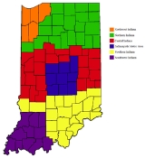
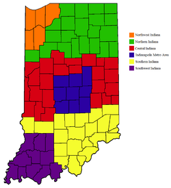
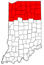
Northern Indiana
The landscape is characterized physically by fairly level terrain ranging from 600 to 1000 ft (182.9 to 304.8 m) above sea level and is probably the flattest part of the state. The Eastern Continental Divide
Eastern Continental Divide
The Eastern Continental Divide, in conjunction with other continental divides of North America, demarcates two watersheds of the Atlantic Ocean: the Gulf of Mexico watershed and the Atlantic Seaboard watershed. Prior to 1760, the divide represented the boundary between British and French colonial...
goes through Northern Indiana following the top of the Valparaiso Moraine
Valparaiso Moraine
The Valparaiso Moraine is a terminal moraine around the Lake Michigan basin in North America. It is a band of high, hilly terrain made up of glacial till and sand that reaches an elevation of near 300 feet above the level of Lake Michigan at its maximum height in Indiana and 17 miles wide at its...
part of the way. Besides some urban area
Urban area
An urban area is characterized by higher population density and vast human features in comparison to areas surrounding it. Urban areas may be cities, towns or conurbations, but the term is not commonly extended to rural settlements such as villages and hamlets.Urban areas are created and further...
s, much of Northern Indiana is farmland.
Heavy industry is as much a part of the economy in the eastern two thirds of Northern Indiana as agriculture and as a result, the region tends to be associated with the Rust Belt
Rust Belt
The Rust Belt is a term that gained currency in the 1980s as the informal description of an area straddling the Midwestern and Northeastern United States, in which local economies traditionally garnered an increased manufacturing sector to add jobs and corporate profits...
. Northern Indiana as a whole is also the most ethnically diverse region in Indiana.
The northwest corner of the state is part of the Chicago metropolitan area and has nearly one million residents. Gary
Gary, Indiana
Gary is a city in Lake County, Indiana, United States. The city is in the southeastern portion of the Chicago metropolitan area and is 25 miles from downtown Chicago. The population is 80,294 at the 2010 census, making it the seventh-largest city in the state. It borders Lake Michigan and is known...
, and the cities and towns that make up the northern half of Lake
Lake County, Indiana
Lake County is a county located in the U.S. state of Indiana. In 2010, its population was 496,005, making it Indiana's second-most populous county. The county seat is Crown Point. This county is part of Northwest Indiana and the Chicago metropolitan area. The county contains a mix of urban,...
, Porter
Porter County, Indiana
Porter County is a county located in the U.S. state of Indiana. As of 2010, the population was 164,343. Much of the population growth has to do with the expansion of the Chicago Metropolitan Area eastward into Indiana. The county seat is Valparaiso...
, and La Porte Counties bordering on Lake Michigan
Lake Michigan
Lake Michigan is one of the five Great Lakes of North America and the only one located entirely within the United States. It is the second largest of the Great Lakes by volume and the third largest by surface area, after Lake Superior and Lake Huron...
, are effectively commuter suburbs of Chicago. Porter and Lake counties are commonly referred to as "The Calumet Region". The name comes from the fact that the Grand Calumet and Little Calumet rivers run through the area. These counties are in the Central Time Zone
Time zone
A time zone is a region on Earth that has a uniform standard time for legal, commercial, and social purposes. In order for the same clock time to always correspond to the same portion of the day as the Earth rotates , different places on the Earth need to have different clock times...
, the same as Chicago. NICTD owns and operates the South Shore Line, a commuter rail line that runs electric-powered trains between South Bend and Chicago
Chicago
Chicago is the largest city in the US state of Illinois. With nearly 2.7 million residents, it is the most populous city in the Midwestern United States and the third most populous in the US, after New York City and Los Angeles...
. Sand dunes and heavy industry share the shoreline of Lake Michigan in northern Indiana. Along the shoreline of Lake Michigan in Northern Indiana
Northern Indiana
Northern Indiana is the region of Indiana including 26 counties bordering parts of Illinois, Michigan, and Ohio. The area is generally sub-classified into other regions. The northwest is economically and culturally intertwined with Chicago, and is considered part of the Chicago metropolitan area...
one can find many parks between the industrial areas. The Indiana Dunes National Lakeshore
Indiana Dunes National Lakeshore
Indiana Dunes National Lakeshore is a U.S. National Lakeshore located in northwest Indiana and managed by the National Park Service. It was authorized by Congress in 1966. The national lakeshore runs for nearly along the southern shore of Lake Michigan, from Gary, Indiana, on the west to Michigan...
and the Indiana Dunes State Park
Indiana Dunes State Park
Indiana DunesDesignationState Park; National Natural LandmarkLocationPorter County, Indiana, USAAddress1600 N 25 EChesterton, IN 46304Nearest CityPorter, IndianaCoordinatesAreaDate of Establishment1925...
are two natural landmarks of the area.
The region is marked with swell and swale
Swale (geographical feature)
A swale is a low tract of land, especially one that is moist or marshy. The term can refer to a natural landscape feature or a human-created one...
topography as it retreats South from Lake Michigan. The ecology changes dramatically between swells, or on opposite sides of the same swell. Plants and animals adapted to marshes are generally found in the swales, while forests or even prickly pear cactus
Opuntia
Opuntia, also known as nopales or paddle cactus , is a genus in the cactus family, Cactaceae.Currently, only prickly pears are included in this genus of about 200 species distributed throughout most of the Americas. Chollas are now separated into the genus Cylindropuntia, which some still consider...
are found in the dryer swells.

Kankakee River
The Kankakee River is a tributary of the Illinois River, approximately long, in northwestern Indiana and northeastern Illinois in the United States. At one time the river drained one of the largest wetlands in North America and furnished a significant portage between the Great Lakes and the...
, which winds through northern Indiana, serves somewhat as a demarcating line between suburban northwest Indiana and the rest of the state. Before it was drained and developed for agriculture, the Kankakee Marsh was one of the largest freshwater marshes in the country. South of the Kankakee is a large area of prairie
Prairie
Prairies are considered part of the temperate grasslands, savannas, and shrublands biome by ecologists, based on similar temperate climates, moderate rainfall, and grasses, herbs, and shrubs, rather than trees, as the dominant vegetation type...
, the eastern edge of the Grand Prairie that covers Iowa
Iowa
Iowa is a state located in the Midwestern United States, an area often referred to as the "American Heartland". It derives its name from the Ioway people, one of the many American Indian tribes that occupied the state at the time of European exploration. Iowa was a part of the French colony of New...
and Illinois
Illinois
Illinois is the fifth-most populous state of the United States of America, and is often noted for being a microcosm of the entire country. With Chicago in the northeast, small industrial cities and great agricultural productivity in central and northern Illinois, and natural resources like coal,...
. The Prairie Chicken
Greater Prairie Chicken
The Greater Prairie Chicken or Pinnated Grouse, Tympanuchus cupido, is a large bird in the grouse family. This North American species was once abundant, but has become extremely rare or extinct over much of its range due to habitat loss. There are current efforts to help this species gain the...
and American Bison
American Bison
The American bison , also commonly known as the American buffalo, is a North American species of bison that once roamed the grasslands of North America in massive herds...
were common in Indiana's pioneer era, but are now extinct as wild species within the state.
The South Bend metropolitan area, in north central Indiana, is the center of commerce in the region better known as Michiana
Michiana
Michiana is a region in northern Indiana and southwestern Michigan centered on the city of South Bend, Indiana. The Chamber of Commerce of St. Joseph County, Indiana defines Michiana as "counties that contribute at least 500 inbound commuting workers to St. Joseph County daily." Those counties...
. Other cities located within the area include Elkhart
Elkhart, Indiana
Elkhart is a city in Elkhart County, Indiana, United States. The city is located east of South Bend, northwest of Fort Wayne, east of Chicago, and north of Indianapolis...
, Mishawaka
Mishawaka, Indiana
Mishawaka is a city on the St. Joseph River and a Twin city of South Bend in St. Joseph County, Indiana, United States. The population was 48,252 as of the 2010 Census...
, Goshen
Goshen, Indiana
Goshen is a city in and the county seat of Elkhart County, Indiana, United States. It is the smaller of the two principal cities of the Elkhart-Goshen Metropolitan Statistical Area, which in turn is part of the South Bend-Elkhart-Mishawaka Combined Statistical Area. It is located in the northern...
, and Warsaw
Warsaw, Indiana
Warsaw is a city in and the county seat of Kosciusko County, Indiana, United States. Cradled among Winona Lake, Pike Lake, Hidden Lake and Center Lake, Warsaw is nicknamed "Lake City," though other cities in the surrounding area are also referred to by that nickname...
. Fort Wayne
Fort Wayne, Indiana
Fort Wayne is a city in the US state of Indiana and the county seat of Allen County. The population was 253,691 at the 2010 Census making it the 74th largest city in the United States and the second largest in Indiana...
, the state's second largest city, is located in the northeastern part of the state where it serves the state as a transportation hub. Other cities located within the area include Huntington
Huntington, Indiana
Huntington, known as the "Lime City", is a small city in and the county seat of Huntington County, Indiana, United States. It is in Huntington Township and Union Township...
and Marion
Marion, Indiana
Marion is a city in Grant County, Indiana, United States. The population was 29,948 as of the 2010 census. The city is the county seat of Grant County...
. East of Fort Wayne is an area of extremely flat land that, before development, was the western-most reach of the Great Black Swamp
Great Black Swamp
The Great Black Swamp, or simply Black Swamp, was a glacially caused wetland in northwest Ohio, United States, extending into extreme northeastern Indiana, that existed from the end of the Wisconsin glaciation until the late 19th century...
.
Northeastern Indiana is home to a number of lakes, many of which are the remains of the glaciers that covered Indiana thousands of years ago and Glacial Lake Maumee. Some of these lakes include Lake James in Pokagon State Park
Pokagon State Park
Pokagon State Park is located in northeastern Indiana close to the village of Fremont and north of Angola. It was named for the 19th-century Potawatomi chief, Leopold Pokagon, and his widely known son, Simon Pokagon, at Richard Lieber's suggestion...
, Lake Maxinkuckee
Lake Maxinkuckee
Lake Maxinkuckee, covering , is the second largest natural lake in the U.S. state of Indiana . It is located near the town of Culver, Indiana, in southwestern Marshall County. Lake Maxinkuckee has a maximum depth of 88 feet and an average depth of 24 feet . Local residents and visitors practice...
, Lake Wawasee
Lake Wawasee
Lake Wawasee, formerly Turkey Lake, is a natural lake southeast of Syracuse in Kosciusko County, Indiana, United States. It is the largest natural lake in Indiana. It is located just east of Indiana State Road 13.-History:...
and Lake Tippecanoe
Lake Tippecanoe
Tippecanoe Lake is a large, glacially-created lake in Kosciusko County in north-central Indiana and is the deepest natural lake in the state.-Location:...
. Lake Wawasee is the largest natural lake in Indiana, while Lake Tippecanoe is the deepest lake, reaching depths of over 120 feet (36.6 m). Both lakes are located in Kosciusko County. Chain O' Lakes State Park, located in Noble County
Noble County, Indiana
As of the census of 2000, there were 46,275 people, 16,696 households, and 12,288 families residing in the county. The population density was 113 people per square mile . There were 18,233 housing units at an average density of 44 per square mile...
, contains 11 lakes, 8 of which are connected by natural channels.
Michiana
The center third of this region is known as the Indiana section of MichianaMichiana
Michiana is a region in northern Indiana and southwestern Michigan centered on the city of South Bend, Indiana. The Chamber of Commerce of St. Joseph County, Indiana defines Michiana as "counties that contribute at least 500 inbound commuting workers to St. Joseph County daily." Those counties...
. South Bend is the cultural and economic center of the Michiana region.
Maumee Valley
The Eastern third of this region centers around the Fort WayneFort Wayne, Indiana
Fort Wayne is a city in the US state of Indiana and the county seat of Allen County. The population was 253,691 at the 2010 Census making it the 74th largest city in the United States and the second largest in Indiana...
area and the Maumee River
Maumee River
The Maumee River is a river in northwestern Ohio and northeastern Indiana in the United States. It is formed at Fort Wayne, Indiana by the confluence of the St. Joseph and St. Marys rivers, and meanders northeastwardly for through an agricultural region of glacial moraines before flowing into the...
basin.
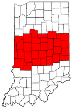
Central Indiana
Hoosier
Hoosier is the official demonym for a resident of the U.S. state of Indiana. Although residents of most U.S. states typically adopt a derivative of the state name, e.g., "Indianan" or "Indianian", natives of Indiana rarely use these. Indiana adopted the nickname "Hoosier State" more than 150...
s consider Central Indiana as the Indianapolis metropolitan area. The region's dominant city by far is Indianapolis
Indianapolis
Indianapolis is the capital of the U.S. state of Indiana, and the county seat of Marion County, Indiana. As of the 2010 United States Census, the city's population is 839,489. It is by far Indiana's largest city and, as of the 2010 U.S...
. Other prominent cities include Lafayette
Lafayette, Indiana
Lafayette is a city in and the county seat of Tippecanoe County, Indiana, United States, northwest of Indianapolis. As of the 2010 census, the city had a total population of 67,140. West Lafayette, on the other side of the Wabash River, is home to Purdue University, which has a large impact on...
, Anderson
Anderson, Indiana
Anderson is a city in and the county seat of Madison County, Indiana, United States. It is the principal city of the Anderson, Indiana Metropolitan Statistical Area which encompasses Madison county. Anderson is the headquarters of the Church of God and home of Anderson University, which is...
, Muncie
Muncie, Indiana
Muncie is a city in Center Township, Delaware County in east central Indiana, best known as the home of Ball State University and the birthplace of the Ball Corporation. It is the principal city of the Muncie, Indiana, Metropolitan Statistical Area, which has a population of 118,769...
, and Terre Haute
Terre Haute, Indiana
Terre Haute is a city and the county seat of Vigo County, Indiana, United States, near the state's western border with Illinois. As of the 2010 census, the city had a total population of 60,785 and its metropolitan area had a population of 170,943. The city is the county seat of Vigo County and...
. Central Indiana is the most populous region of Indiana. The primary economic engines of Central Indiana are education and research, agriculture and manufacturing, and as a result, some of the larger cities in the region are dealing with Rust Belt issues similar to Northern Indiana. Major universities include Purdue University
Purdue University
Purdue University, located in West Lafayette, Indiana, U.S., is the flagship university of the six-campus Purdue University system. Purdue was founded on May 6, 1869, as a land-grant university when the Indiana General Assembly, taking advantage of the Morrill Act, accepted a donation of land and...
, Indiana University Purdue University Indianapolis, Ball State University
Ball State University
Ball State University is a state-run research university located in Muncie, Indiana. It is also known as Ball State or simply BSU.Located on the northwest side of the city, Ball State's campus spans and includes 106 buildings...
, and Indiana State University
Indiana State University
Indiana State University is a public university located in Terre Haute, Indiana, United States.The Princeton Review has named Indiana State as one of the "Best in the Midwest" seven years running, and the College of Education's Graduate Program was recently named as a 'Top 100' by U.S...
.
Physically, the land in Central Indiana is characterized primarily by low, gently rolling hills and shallow valleys. Some counties of the region, like Howard County
Howard County, Indiana
Howard County is one of 92 counties in the U.S. state of Indiana. It is part of the Kokomo, Indiana, Metropolitan Statistical Area, which consists of Howard and Tipton counties. Originally named Richardville County, it was rechristened in 1844 to commemorate General Tilghman Ashurst Howard. As of...
, are more flat in nature, while others, such as Morgan County
Morgan County, Indiana
Morgan County is a county located in the U.S. state of Indiana. As of 2010, the population was 68,894. The county seat is Martinsville. Morgan is one of seven counties contiguous to Marion County, and is located between Indianapolis, in Marion County, and Bloomington, located in Monroe County...
are more rugged and hilly, while Tippecanoe County, trisected by the Wabash River, Tippecanoe River, and Wildcat Creek, has perhaps the most diverse physiography of the region. Elevation ranges from 600 to 1000 ft (182.9 to 304.8 m) (and more) above sea level. Forests and farmland line Central Indiana's gently rolling plains and river valleys. The highest point in Indiana is Hoosier Hill
Hoosier Hill
Hoosier Hill is the highest natural point in the state of Indiana at 1,257 feet . It is in a rural area of Franklin Township, Wayne County to the northwest of Bethel. The nearest intersection to the high point is Elliot Road and County Line Road...
, at 1257 feet (383.1 m) above sea level in northern Wayne County
Wayne County, Indiana
Wayne County is a county located in the U.S. state of Indiana. As of the 2010 census, the population was 68,917. The county seat is Richmond.-History:...
.
The state capital and largest city, Indianapolis
Indianapolis, Indiana
Indianapolis is the capital of the U.S. state of Indiana, and the county seat of Marion County, Indiana. As of the 2010 United States Census, the city's population is 839,489. It is by far Indiana's largest city and, as of the 2010 U.S...
, is situated in the central portion of the state. It is intersected by numerous Interstates
Interstate Highway System
The Dwight D. Eisenhower National System of Interstate and Defense Highways, , is a network of limited-access roads including freeways, highways, and expressways forming part of the National Highway System of the United States of America...
, U.S. highways
United States Numbered Highways
The system of United States Numbered Highways is an integrated system of roads and highways in the United States numbered within a nationwide grid...
, and railways giving the state its motto as "The Crossroads of America". Other large cities and located within the area include Anderson
Anderson, Indiana
Anderson is a city in and the county seat of Madison County, Indiana, United States. It is the principal city of the Anderson, Indiana Metropolitan Statistical Area which encompasses Madison county. Anderson is the headquarters of the Church of God and home of Anderson University, which is...
, Carmel
Carmel, Indiana
Carmel is a city in Hamilton County, Indiana, United States located immediately north of Indianapolis, Indiana. The population was 79,191 at the 2010 census, and is one of the most affluent communities in the Midwest....
, Columbus
Columbus, Indiana
Columbus is a city in and the county seat of Bartholomew County, Indiana, United States. The population was 44,061 at the 2010 census, and the current mayor is Fred Armstrong. Located approximately 40 miles south of Indianapolis, on the east fork of the White River, it is the state's 20th largest...
, Kokomo
Kokomo, Indiana
Kokomo is a city in and the county seat of Howard County, Indiana, United States, Indiana's 13th largest city. It is the principal city of the Kokomo, Indiana Metropolitan Statistical Area, which includes all of Howard and Tipton counties....
, Lafayette
Lafayette, Indiana
Lafayette is a city in and the county seat of Tippecanoe County, Indiana, United States, northwest of Indianapolis. As of the 2010 census, the city had a total population of 67,140. West Lafayette, on the other side of the Wabash River, is home to Purdue University, which has a large impact on...
, Richmond
Richmond, Indiana
Richmond is a city largely within Wayne Township, Wayne County, in east central Indiana, United States, which borders Ohio. The city also includes the Richmond Municipal Airport, which is in Boston Township and separated from the rest of the city...
, and Terre Haute
Terre Haute, Indiana
Terre Haute is a city and the county seat of Vigo County, Indiana, United States, near the state's western border with Illinois. As of the 2010 census, the city had a total population of 60,785 and its metropolitan area had a population of 170,943. The city is the county seat of Vigo County and...
.
Rural areas in the central portion of the state are typically composed of a patchwork of fields
Field (agriculture)
In agriculture, the word field refers generally to an area of land enclosed or otherwise and used for agricultural purposes such as:* Cultivating crops* Usage as a paddock or, generally, an enclosure of livestock...
and forest
Forest
A forest, also referred to as a wood or the woods, is an area with a high density of trees. As with cities, depending where you are in the world, what is considered a forest may vary significantly in size and have various classification according to how and what of the forest is composed...
ed areas. The geography of Central Indiana consists of gently rolling hills and sandstone
Sandstone
Sandstone is a sedimentary rock composed mainly of sand-sized minerals or rock grains.Most sandstone is composed of quartz and/or feldspar because these are the most common minerals in the Earth's crust. Like sand, sandstone may be any colour, but the most common colours are tan, brown, yellow,...
ravines carved out by the retreating glaciers. Many of these ravines can be found in west-central Indiana, specifically along Sugar Creek in Turkey Run State Park
Turkey Run State Park
Turkey Run State Park is located in Parke County, Indiana, in the west-central part of the state on State Road 47 two miles east of U.S. 41. It was Indiana's second state park, with the first parcel of land being purchased in 1916 at the cost of $40,200 when the State Park system was first...
and Shades State Park
Shades State Park
Shades State Park is a state park in Montgomery, Parke, and Fountain Counties in Indiana. It is located west-northwest of Indianapolis, Indiana. In the last decades of the 19th century, the area was a resort with a forty-room inn. In the 1930s a man named Joseph Frisz acquired the land in order...
.
Southern Indiana

Evansville, Indiana
Evansville is the third-largest city in the U.S. state of Indiana and the largest city in Southern Indiana. As of the 2010 census, the city had a total population of 117,429. It is the county seat of Vanderburgh County and the regional hub for both Southwestern Indiana and the...
, the third largest city in Indiana, is located in the southwestern corner of the state. It is located in a tri-state area
Illinois-Indiana-Kentucky Tri-State Area
The Illinois–Indiana–Kentucky Tri-State Area is a tri-state area where the states of Illinois, Indiana, and Kentucky intersect. The area is defined mainly by the television viewing area and consists of ten Illinois counties, eleven Indiana counties, and nine Kentucky counties...
that includes Illinois, Indiana, and Kentucky. The south-central cities of Clarksville
Clarksville, Indiana
Clarksville is a town in Clark County, Indiana, United States, along the Ohio River as a part of the Louisville Metropolitan area. The population was 21,724 at the 2010 census. The town, once a home site to George Rogers Clark, was founded in 1783 and is the oldest American town in the Northwest...
, Jeffersonville
Jeffersonville, Indiana
Jeffersonville is a city in Clark County, Indiana, along the Ohio River. Locally, the city is often referred to by the abbreviated name Jeff. It is directly across the Ohio River to the north of Louisville, Kentucky along I-65. The population was 44,953 at the 2010 census...
, and New Albany
New Albany, Indiana
New Albany is a city in Floyd County, Indiana, United States, situated along the Ohio River opposite Louisville, Kentucky. In 1900, 20,628 people lived in New Albany; in 1910, 20,629; in 1920, 22,992; and in 1940, 25,414. The population was 36,372 at the 2010 census. The city is the county seat of...
are part of the Louisville
Louisville, Kentucky
Louisville is the largest city in the U.S. state of Kentucky, and the county seat of Jefferson County. Since 2003, the city's borders have been coterminous with those of the county because of a city-county merger. The city's population at the 2010 census was 741,096...
metropolitan area. Vincennes
Vincennes, Indiana
Vincennes is a city in and the county seat of Knox County, Indiana, United States. It is located on the Wabash River in the southwestern part of the state. The population was 18,701 at the 2000 census...
, founded by French traders in 1732 and the oldest European settlement in the state, is located on the Wabash River
Wabash River
The Wabash River is a river in the Midwestern United States that flows southwest from northwest Ohio near Fort Recovery across northern Indiana to southern Illinois, where it forms the Illinois-Indiana border before draining into the Ohio River, of which it is the largest northern tributary...
as served as the first capitol of the Indiana Territory. Vincennes is also home of the Pantheon Theatre
Pantheon Theatre
The Pantheon Theatre was constructed in 1919 on the corner of 5th and Main Street in Vincennes, Indiana. It was built to hold 1200 people. One of the highest paid interior decorators in the world was hired to supervise the decorating of the theatre. The Pantheon's interior was highly embellished...
. Indiana was settled from southern periphery northward and the state's oldest settlements and first capital, Corydon
Corydon, Indiana
Corydon is a town in Harrison Township, Harrison County, Indiana, United States, founded in 1808, and is known as Indiana's First State Capital. After Vincennes, Corydon was the second capital of the Indiana Territory from May 1, 1813, until December 11, 1816. After statehood, the town was the...
are in southern Indiana. Until 1950, the United States Census
United States Census
The United States Census is a decennial census mandated by the United States Constitution. The population is enumerated every 10 years and the results are used to allocate Congressional seats , electoral votes, and government program funding. The United States Census Bureau The United States Census...
found the center of population to lie in southern Indiana.
Southern Indiana is a mixture of farmland, forest and very hilly areas, especially near Louisville and in the south central lime hills areas. The Hoosier National Forest
Hoosier National Forest
The Hoosier National Forest, in the hills of south central Indiana, is a property managed by the United States Forest Service. Composed of four separate sections, it has a total area of . It is headquartered in Bedford, with a regional office in Tell City...
is a 200000 acres (809.4 km²) nature preserve in south central Indiana. Southern Indiana's topography is more varied than that in the north and generally contains more hills and geographic variation than the northern portion, such as the "Knobs,"
Knobstone Escarpment
The Knobstone Escarpment is a rugged geologic region in Southern Indiana. Physically, the Knobstone Escarpment is the most rugged terrain in Indiana. The highest hill in the area is Weed Patch Hill, with an elevation of 1,056 feet above sea level....
a series of 1000 ft (304.8 m) hills that run parallel to the Ohio River in south-central Indiana. The bottomlands of Indiana, where the Wabash and Ohio converge, hosts numerous plant and animal species normally found in the Lower Mississippi and Gulf Coast region of the United States. Brown County
Brown County, Indiana
Brown County is a county located in the U.S. state of Indiana. As of 2010, the population is 15,242. The county seat is Nashville.- History :...
is well-known for its hills covered with colorful autumn foliage, T.C. Steele's former home, and Nashville
Nashville, Indiana
Nashville is a town in Washington Township, Brown County, Indiana, United States. The population was 803 at the 2010 census. The town is the county seat of Brown County and is the county's only incorporated town...
, the county seat and shopping destination. Harrison and Crawford Counties boast three of the state's most popular commercial caves at Wyandotte, Marengo
Marengo Cave
Marengo Cave is located in Marengo, Indiana. One of only four show caves in Indiana, public tours of the cave have been given since 1883. Tours commenced just days after the cave's discovery by two school children.-The Discovery:...
, and Squire Boone Caverns
Squire Boone Caverns
Squire Boone Caverns and Village is a cavern exploration attraction in Mauckport, Indiana . The park consists of a one-hour walking tour into the caverns, as well as a working pioneer village and grist mill.-Park's History:...
.
The limestone
Limestone
Limestone is a sedimentary rock composed largely of the minerals calcite and aragonite, which are different crystal forms of calcium carbonate . Many limestones are composed from skeletal fragments of marine organisms such as coral or foraminifera....
geology of Southern Indiana has created numerous caves and one of the largest limestone quarry regions in the United States. Many of Indiana's official buildings, such as the Indiana Statehouse, the downtown monuments, the Indiana University School of Law in Indianapolis, many buildings at Indiana University in Bloomington, and the Indiana Government Center are all examples of Indiana architecture made with Indiana limestone. Indiana limestone has also been used in many other famous structures in the US, such as the Empire State Building
Empire State Building
The Empire State Building is a 102-story landmark skyscraper and American cultural icon in New York City at the intersection of Fifth Avenue and West 34th Street. It has a roof height of 1,250 feet , and with its antenna spire included, it stands a total of 1,454 ft high. Its name is derived...
, the Pentagon
The Pentagon
The Pentagon is the headquarters of the United States Department of Defense, located in Arlington County, Virginia. As a symbol of the U.S. military, "the Pentagon" is often used metonymically to refer to the Department of Defense rather than the building itself.Designed by the American architect...
, and the Washington National Cathedral
Washington National Cathedral
The Washington National Cathedral, officially named the Cathedral Church of Saint Peter and Saint Paul, is a cathedral of the Episcopal Church located in Washington, D.C., the capital of the United States. Of neogothic design, it is the sixth-largest cathedral in the world, the second-largest in...
. In addition, 35 of the 50 state capitol buildings are made of Indiana limestone.