

Geography of Hungary
Encyclopedia
With a land area of 93,030 square kilometers, Hungary
is a country in Central Europe
. It measures about 250 kilometers from north to south and 524 kilometers from east to west. It has 2,258 kilometers of boundaries, shared with Austria
to the west, Serbia
, Croatia
and Slovenia
to the south and southwest, Romania
to the southeast, Ukraine
to the northeast, and Slovakia
to the north.
Hungary's modern borders were first established after World War I
when, by the terms of the Treaty of Trianon
in 1920, it lost more than 71% of what had formerly been the Kingdom of Hungary
, 58.5% of its population, and 32% of the Hungarians. The country secured some boundary revisions from 1938 to 1941: In 1938 the First Vienna Award
gave back territory from Czechoslovakia
, in 1939 Hungary occupied Carpatho-Ukraine
. In 1940 the Second Vienna Award
gave back Northern Transylvania
and finally Hungary occupied the Bácska and Muraköz regions during the Invasion of Yugoslavia
. However, Hungary lost these territories again with its defeat in World War II
. After World War II, the Trianon boundaries were restored with a small revision that benefited Czechoslovakia
.
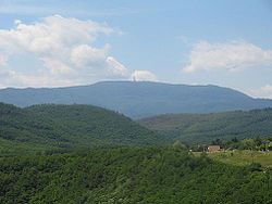
 Most of the country has an elevation of fewer than 200 meters. Although Hungary has several moderately high ranges of mountains, those reaching heights of 300 meters or more cover less than 2% of the country. The highest point in the country is Kékes
(1,014 m) in the Mátra Mountains
northeast of Budapest
. The lowest spot is 77.6 meters above sea level, located in the south of Hungary, near Szeged
.
The major rivers in the country are the Danube
and Tisza
. The Danube also flows through parts of Germany
, Austria
, Croatia
, Slovakia
, Serbia
, and Romania
.It is navigable within Hungary for 418 kilometers. The Tisza River is navigable for 444 kilometers in the country. Less important rivers include the Drava
along the Croatia
n border, the Rába
, the Szamos, the Sió
, and the Ipoly along the Slovakian border. Hungary has three major lakes. Lake Balaton
, the largest, is 78 kilometers long and from 3 to 14 kilometers wide, with an area of 592 square kilometers. Hungarians often refer to it as the Hungarian Sea. It is Central Europe
's largest freshwater
lake and an important recreation area. Its shallow waters offer good summer swimming, and in winter its frozen surface provides excellent opportunities for winter sports. Smaller bodies of water are Lake Velence
(26 square kilometers) in Fejér County and Lake Fertő (Neusiedler See
--about 82 square kilometers within Hungary).
Hungary has three major geographic regions (which are subdivided to seven smaller ones): the Great Alföld, lying east of the Danube River; the Transdanubia
, a hilly region lying west of the Danube and extending to the Austrian foothills of the Alps
; and the North Hungarian Mountains, which is a mountainous and hilly country beyond the northern boundary of the Great Hungarian Plain.
The country's best natural resource is fertile land, although soil quality varies greatly. About 70% of the country's total territory is suitable for agriculture; of this portion, 72% is arable land. Hungary lacks extensive domestic sources of energy and raw materials needed for industrial development.
The Little Alföld or Little Hungarian Plain is a plain (tectonic basin) of approximately 8,000 km2 in northwestern Hungary, southwestern Slovakia and eastern Austria, along the lower course of the Rába
River, with high quality fertile soils.
The Transdanubia region lies in the western part of the country, bounded by the Danube River, the Drava River, and the remainder of the country's border with Slovenia and Croatia. It lies south and west of the course of the Danube. It contains Lake Fertő and Lake Balaton. The region consists mostly of rolling hills. Transdanubia is primarily an agricultural area, with flourishing crops, livestock, and viticulture. Mineral deposits and oil are found in Zala
county close to the border of Croatia.
The Great Alföld contains the basin of the Tisza River and its branches. It encompasses more than half of the country's territory. Bordered by mountains on all sides, it has a variety of terrains, including regions of fertile soil, sandy areas, wastelands, and swampy areas. Hungarians have inhabited the Great Plain for at least a millennium. Here is found the puszta
, a long, and uncultivated expanse (the most famous such area still in existence is the Hortobágy
), with which much Hungarian folklore is associated. In earlier centuries, the Great Plain was unsuitable for farming because of frequent flooding. Instead, it was the home of massive herds of cattle and horses. In the last half of the nineteenth century, the government sponsored programs to control the riverways and expedite inland drainage in the Great Plain. With the danger of recurrent flooding largely eliminated, much of the land was placed under cultivation, and herding ceased to be a major contributor to the area's economy.
Although the majority of the country has an elevation lesser than 300 meters, Hungary
has several moderately high ranges of mountains. They can be classified to four geographic regions, from west to east: Alpokalja
, Transdanubian Mountains, Mecsek
and North Hungarian Mountains. Alpokalja (literally the foothills of the Alps
) is located along the Austria
n border; its highest point is Írott-kő
with an elevation of 882 metres. The Transdanubian Mountains stretch from the west part of Lake Balaton
to the Danube Bend near Budapest
, where it meets the North Hungarian Mountains. Its tallest peak is the 757 m high Pilis
. Mecsek
is the southernmost Hungarian mountain range, located north from Pécs
- Its highest point is the Zengő
with 682 metres.
The North Hungarian Mountains lie north of Budapest and run in a northeasterly direction south of the border with Slovakia. The higher ridges, which are mostly forested, have rich coal and iron deposits. Minerals are a major resource of the area and have long been the basis of the industrial economies of cities in the region. Viticulture is also important, producing the famous Tokaji
wine. The highest peak of it is the Kékes
, located in the Mátra
mountain range.
, with cold winters and warm to hot summers. The average annual temperature is about 10 °C (50 °F), in summer 27 to 35 °C (80.6 to 95 F), and in winter 0 to -15 °C (32 to 5 F), with extremes ranging from about 42 °C (107.6 °F) in summer to -29 °C in winter. Average yearly rainfall is about 600 mm (23.6 in). Distribution and frequency of rainfall are unpredictable. The western part of the country usually receives more rain than the eastern part, where severe droughts may occur in summertime. Weather conditions in the Great Plain can be especially harsh, with hot summers, cold winters, and scant rainfall.
By the 1980s, the countryside was beginning to show the effects of pollution, both from herbicides used in agriculture and from industrial pollutants. Most noticeable was the gradual contamination of the country's bodies of water, endangering fish and wildlife. Although concern was mounting over these disturbing threats to the environment, no major steps had yet been taken to arrest them.
's westernmost settlement is Felsőszölnök
in Vas county, the easternmost is Garbolc
in Szabolcs-Szatmár-Bereg
county, the northernmost is Hollóháza
in Borsod-Abaúj-Zemplén
county and the southernmost is Kásád
in Baranya county.
The country's highest point is Kékes
(1014 m) while the lowest is River Tisza
near Szeged
(78 m).
's most important natural resources is arable land
. It covers about 49.58% of the country, which is outstanding in the world (see the related map). The mass majority of the fertile soil
has a good quality.
The most important agricultural zones are the Little Hungarian Plain
(it has the highest quality fertile soil in average), Transdanubia
, and the Great Hungarian Plain
. The last covers more than half of the country (52,000 km2 in number), whereas soil quality varies extremely; the territory even contains a small, grassy semi-desert, the so-called puszta
(steppe in English). Puszta is exploited by sheep and cattle
raising.
The most important Hungarian agricultural products include corn
, wheat
, barley
, oat
, sunflower
, poppy
, potato
, millet
, sugar-beet
, flax
, and many other plants. There are also some newly naturalized plants too, for example amaranth
. Poppy seed
is part of the traditional Hungarian cuisine.
The country is well known for producing high quality green pepper, called paprika
. There are numerous fruits reared, including many subspecies of apple
, pear
, peach
, grape
, apricot
, water melon, cantaloupe
, etc.
Hungary does not grow any GMO
products, thus these products are mainly imported from the United States
. They cannot, however, be distributed without a mark on the wrapping.
in which the word for "wine" does not derive from the Latin, being Greek
– and Hungarian
. The Hungarian word is bor.
Viticulture has been recorded in the territory of today's Hungary already in the Roman times, who were responsible for the introduction of the cultivation of wines. The arriving Hungarians took over the practice and maintained it ever since.
Today, there are numerous wine regions in Hungary, producing quality and inexpensive wines as well, comparable to Western European ones. The majority of the country's wine regions are located in the mountains or in the hills, such as Transdanubian Mountains, North Hungarian Mountains, Villány Mountains
, and so on. Important ones include the regions of Eger
, Hajós
, Somló
, Sopron
, Villány
, Szekszárd
, and Tokaj-Hegyalja
.
s. These are mainly mountainous areas, such as the North Hungarian and the Transdanubian Mountains, and the Alpokalja
. The composition of forests is various, with trees like fir
, beech
, oak
, willow
, acacia
, plane
, etc.
Hungary
Hungary , officially the Republic of Hungary , is a landlocked country in Central Europe. It is situated in the Carpathian Basin and is bordered by Slovakia to the north, Ukraine and Romania to the east, Serbia and Croatia to the south, Slovenia to the southwest and Austria to the west. The...
is a country in Central Europe
Central Europe
Central Europe or alternatively Middle Europe is a region of the European continent lying between the variously defined areas of Eastern and Western Europe...
. It measures about 250 kilometers from north to south and 524 kilometers from east to west. It has 2,258 kilometers of boundaries, shared with Austria
Austria
Austria , officially the Republic of Austria , is a landlocked country of roughly 8.4 million people in Central Europe. It is bordered by the Czech Republic and Germany to the north, Slovakia and Hungary to the east, Slovenia and Italy to the south, and Switzerland and Liechtenstein to the...
to the west, Serbia
Serbia
Serbia , officially the Republic of Serbia , is a landlocked country located at the crossroads of Central and Southeast Europe, covering the southern part of the Carpathian basin and the central part of the Balkans...
, Croatia
Croatia
Croatia , officially the Republic of Croatia , is a unitary democratic parliamentary republic in Europe at the crossroads of the Mitteleuropa, the Balkans, and the Mediterranean. Its capital and largest city is Zagreb. The country is divided into 20 counties and the city of Zagreb. Croatia covers ...
and Slovenia
Slovenia
Slovenia , officially the Republic of Slovenia , is a country in Central and Southeastern Europe touching the Alps and bordering the Mediterranean. Slovenia borders Italy to the west, Croatia to the south and east, Hungary to the northeast, and Austria to the north, and also has a small portion of...
to the south and southwest, Romania
Romania
Romania is a country located at the crossroads of Central and Southeastern Europe, on the Lower Danube, within and outside the Carpathian arch, bordering on the Black Sea...
to the southeast, Ukraine
Ukraine
Ukraine is a country in Eastern Europe. It has an area of 603,628 km², making it the second largest contiguous country on the European continent, after Russia...
to the northeast, and Slovakia
Slovakia
The Slovak Republic is a landlocked state in Central Europe. It has a population of over five million and an area of about . Slovakia is bordered by the Czech Republic and Austria to the west, Poland to the north, Ukraine to the east and Hungary to the south...
to the north.
Hungary's modern borders were first established after World War I
World War I
World War I , which was predominantly called the World War or the Great War from its occurrence until 1939, and the First World War or World War I thereafter, was a major war centred in Europe that began on 28 July 1914 and lasted until 11 November 1918...
when, by the terms of the Treaty of Trianon
Treaty of Trianon
The Treaty of Trianon was the peace agreement signed in 1920, at the end of World War I, between the Allies of World War I and Hungary . The treaty greatly redefined and reduced Hungary's borders. From its borders before World War I, it lost 72% of its territory, which was reduced from to...
in 1920, it lost more than 71% of what had formerly been the Kingdom of Hungary
Kingdom of Hungary
The Kingdom of Hungary comprised present-day Hungary, Slovakia and Croatia , Transylvania , Carpatho Ruthenia , Vojvodina , Burgenland , and other smaller territories surrounding present-day Hungary's borders...
, 58.5% of its population, and 32% of the Hungarians. The country secured some boundary revisions from 1938 to 1941: In 1938 the First Vienna Award
First Vienna Award
The First Vienna Award was the result of the First Vienna Arbitration, which took place at Vienna's Belvedere Palace on November 2, 1938. The Arbitration and Award were direct consequences of the Munich Agreement...
gave back territory from Czechoslovakia
Czechoslovakia
Czechoslovakia or Czecho-Slovakia was a sovereign state in Central Europe which existed from October 1918, when it declared its independence from the Austro-Hungarian Empire, until 1992...
, in 1939 Hungary occupied Carpatho-Ukraine
Carpatho-Ukraine
Carpatho-Ukraine was an autonomous region within Czechoslovakia from late 1938 to March 15, 1939. It declared itself an independent republic on March 15, 1939, but was occupied by Hungary between March 15 and March 18, 1939, remaining under Hungarian control until the Nazi occupation of Hungary in...
. In 1940 the Second Vienna Award
Second Vienna Award
The Second Vienna Award was the second of two Vienna Awards arbitrated by the Nazi Germany and Fascist Italy. Rendered on August 30, 1940, it re-assigned the territory of Northern Transylvania from Romania to Hungary.-Prelude and historical background :After the World War I, the multi-ethnic...
gave back Northern Transylvania
Northern Transylvania
Northern Transylvania is a region of Transylvania, situated within the territory of Romania. The population is largely composed of both ethnic Romanians and Hungarians, and the region has been part of Romania since 1918 . During World War II, as a consequence of the territorial agreement known as...
and finally Hungary occupied the Bácska and Muraköz regions during the Invasion of Yugoslavia
Invasion of Yugoslavia
The Invasion of Yugoslavia , also known as the April War , was the Axis Powers' attack on the Kingdom of Yugoslavia which began on 6 April 1941 during World War II...
. However, Hungary lost these territories again with its defeat in World War II
World War II
World War II, or the Second World War , was a global conflict lasting from 1939 to 1945, involving most of the world's nations—including all of the great powers—eventually forming two opposing military alliances: the Allies and the Axis...
. After World War II, the Trianon boundaries were restored with a small revision that benefited Czechoslovakia
Czechoslovakia
Czechoslovakia or Czecho-Slovakia was a sovereign state in Central Europe which existed from October 1918, when it declared its independence from the Austro-Hungarian Empire, until 1992...
.
Topography
Kékes
Kékes is Hungary's highest mountain, at above sea level. It lies northeast of Gyöngyös, in the Mátra range of Heves county. It is Hungary's third most popular tourist attraction, after Lake Balaton and the Danube, and has a number of hotels and skiing pistes. The Kekesteto TV Tower stands at the...
(1,014 m) in the Mátra Mountains
Mátra
Mátra is a mountain range in northern Hungary, between the towns Gyöngyös and Eger. The country's highest peak, Kékestető , belongs to this mountain range....
northeast of Budapest
Budapest
Budapest is the capital of Hungary. As the largest city of Hungary, it is the country's principal political, cultural, commercial, industrial, and transportation centre. In 2011, Budapest had 1,733,685 inhabitants, down from its 1989 peak of 2,113,645 due to suburbanization. The Budapest Commuter...
. The lowest spot is 77.6 meters above sea level, located in the south of Hungary, near Szeged
Szeged
' is the third largest city of Hungary, the largest city and regional centre of the Southern Great Plain and the county town of Csongrád county. The University of Szeged is one of the most distinguished universities in Hungary....
.
The major rivers in the country are the Danube
Danube
The Danube is a river in the Central Europe and the Europe's second longest river after the Volga. It is classified as an international waterway....
and Tisza
Tisza
The Tisza or Tisa is one of the main rivers of Central Europe. It rises in Ukraine, and is formed near Rakhiv by the junction of headwaters White Tisa, whose source is in the Chornohora mountains and Black Tisa, which springs in the Gorgany range...
. The Danube also flows through parts of Germany
Germany
Germany , officially the Federal Republic of Germany , is a federal parliamentary republic in Europe. The country consists of 16 states while the capital and largest city is Berlin. Germany covers an area of 357,021 km2 and has a largely temperate seasonal climate...
, Austria
Austria
Austria , officially the Republic of Austria , is a landlocked country of roughly 8.4 million people in Central Europe. It is bordered by the Czech Republic and Germany to the north, Slovakia and Hungary to the east, Slovenia and Italy to the south, and Switzerland and Liechtenstein to the...
, Croatia
Croatia
Croatia , officially the Republic of Croatia , is a unitary democratic parliamentary republic in Europe at the crossroads of the Mitteleuropa, the Balkans, and the Mediterranean. Its capital and largest city is Zagreb. The country is divided into 20 counties and the city of Zagreb. Croatia covers ...
, Slovakia
Slovakia
The Slovak Republic is a landlocked state in Central Europe. It has a population of over five million and an area of about . Slovakia is bordered by the Czech Republic and Austria to the west, Poland to the north, Ukraine to the east and Hungary to the south...
, Serbia
Serbia
Serbia , officially the Republic of Serbia , is a landlocked country located at the crossroads of Central and Southeast Europe, covering the southern part of the Carpathian basin and the central part of the Balkans...
, and Romania
Romania
Romania is a country located at the crossroads of Central and Southeastern Europe, on the Lower Danube, within and outside the Carpathian arch, bordering on the Black Sea...
.It is navigable within Hungary for 418 kilometers. The Tisza River is navigable for 444 kilometers in the country. Less important rivers include the Drava
Drava
Drava or Drave is a river in southern Central Europe, a tributary of the Danube. It sources in Toblach/Dobbiaco, Italy, and flows east through East Tirol and Carinthia in Austria, into Slovenia , and then southeast, passing through Croatia and forming most of the border between Croatia and...
along the Croatia
Croatia
Croatia , officially the Republic of Croatia , is a unitary democratic parliamentary republic in Europe at the crossroads of the Mitteleuropa, the Balkans, and the Mediterranean. Its capital and largest city is Zagreb. The country is divided into 20 counties and the city of Zagreb. Croatia covers ...
n border, the Rába
Rába
The Rába is a river in southeastern Austria and western Hungary and a right tributary of the Danube. Its source is in Austria, some kilometres east of Bruck an der Mur below Heubodenhöhe Hill. It flows through the Austrian states of Styria and Burgenland, and the Hungarian counties of Vas and...
, the Szamos, the Sió
Sió
Sió is an artificial channel in central Hungary. It is the outlet of Lake Balaton. It flows out of the lake in the city Siófok. It flows along the city Szekszárd, and a few km east of this city it flows into the river Danube. The river Sió flows through the Hungarian counties Somogy, Fejér and Tolna....
, and the Ipoly along the Slovakian border. Hungary has three major lakes. Lake Balaton
Lake Balaton
Lake Balaton is a freshwater lake in the Transdanubian region of Hungary. It is the largest lake in Central Europe, and one of its foremost tourist destinations. As Hungary is landlocked , Lake Balaton is often affectionately called the "Hungarian Sea"...
, the largest, is 78 kilometers long and from 3 to 14 kilometers wide, with an area of 592 square kilometers. Hungarians often refer to it as the Hungarian Sea. It is Central Europe
Central Europe
Central Europe or alternatively Middle Europe is a region of the European continent lying between the variously defined areas of Eastern and Western Europe...
's largest freshwater
Freshwater
Fresh water is naturally occurring water on the Earth's surface in ice sheets, ice caps, glaciers, bogs, ponds, lakes, rivers and streams, and underground as groundwater in aquifers and underground streams. Fresh water is generally characterized by having low concentrations of dissolved salts and...
lake and an important recreation area. Its shallow waters offer good summer swimming, and in winter its frozen surface provides excellent opportunities for winter sports. Smaller bodies of water are Lake Velence
Lake Velence
Lake Velence is the third largest lake in Hungary. It is a popular holiday destination among Hungarians.The lake has an area of 26 km2., one third of which is covered by the common reed...
(26 square kilometers) in Fejér County and Lake Fertő (Neusiedler See
Neusiedler See
Lake Neusiedl is the second largest steppe lake in Central Europe, straddling the Austrian–Hungarian border. The lake covers 315 km², of which 240 km² is on the Austrian side and 75 km² on the Hungarian side. The lake's drainage basin has an area of about 1,120 km²...
--about 82 square kilometers within Hungary).
Hungary has three major geographic regions (which are subdivided to seven smaller ones): the Great Alföld, lying east of the Danube River; the Transdanubia
Transdanubia
Transdanubia is a traditional region of Hungary.-Traditional interpretation:The borders of Transdanubia are the Danube river , the Drava and Mura rivers and the foothills of the Alps roughly along the border between Hungary and Austria .Transdanubia comprises the counties of Győr-Moson-Sopron,...
, a hilly region lying west of the Danube and extending to the Austrian foothills of the Alps
Alps
The Alps is one of the great mountain range systems of Europe, stretching from Austria and Slovenia in the east through Italy, Switzerland, Liechtenstein and Germany to France in the west....
; and the North Hungarian Mountains, which is a mountainous and hilly country beyond the northern boundary of the Great Hungarian Plain.
The country's best natural resource is fertile land, although soil quality varies greatly. About 70% of the country's total territory is suitable for agriculture; of this portion, 72% is arable land. Hungary lacks extensive domestic sources of energy and raw materials needed for industrial development.
Rivers and lakes
|
| ||||||||||||||||||||||||||||||||||||||||||||||||||
Plains and hills
-
- Main articles: Little Hungarian PlainLittle Hungarian PlainThe Little Hungarian Plain or Little Alföld is a plain of appr. 8,000 km² in northwestern Hungary, south-western Slovakia , and eastern Austria...
, TransdanubiaTransdanubiaTransdanubia is a traditional region of Hungary.-Traditional interpretation:The borders of Transdanubia are the Danube river , the Drava and Mura rivers and the foothills of the Alps roughly along the border between Hungary and Austria .Transdanubia comprises the counties of Győr-Moson-Sopron,...
, Great Alföld.
- Main articles: Little Hungarian Plain
The Little Alföld or Little Hungarian Plain is a plain (tectonic basin) of approximately 8,000 km2 in northwestern Hungary, southwestern Slovakia and eastern Austria, along the lower course of the Rába
Rába
The Rába is a river in southeastern Austria and western Hungary and a right tributary of the Danube. Its source is in Austria, some kilometres east of Bruck an der Mur below Heubodenhöhe Hill. It flows through the Austrian states of Styria and Burgenland, and the Hungarian counties of Vas and...
River, with high quality fertile soils.
The Transdanubia region lies in the western part of the country, bounded by the Danube River, the Drava River, and the remainder of the country's border with Slovenia and Croatia. It lies south and west of the course of the Danube. It contains Lake Fertő and Lake Balaton. The region consists mostly of rolling hills. Transdanubia is primarily an agricultural area, with flourishing crops, livestock, and viticulture. Mineral deposits and oil are found in Zala
Zala
Zala is the name of an administrative county in Hungary. Itlies in south-western Hungary. It is named after the Zala River. It shares borders with Croatia and Slovenia and the Hungarian counties Vas, Veszprém and Somogy. The capital of Zala county is Zalaegerszeg. Its area is 3784 km²...
county close to the border of Croatia.
The Great Alföld contains the basin of the Tisza River and its branches. It encompasses more than half of the country's territory. Bordered by mountains on all sides, it has a variety of terrains, including regions of fertile soil, sandy areas, wastelands, and swampy areas. Hungarians have inhabited the Great Plain for at least a millennium. Here is found the puszta
Puszta
Puszta is a steppe biome on the Great Hungarian Plain around the River Tisza in the eastern part of Hungary as well as on the western part of Hungary and in the Austrian Burgenland. The Hungarian puszta is an enclave of the Eurasian Steppe....
, a long, and uncultivated expanse (the most famous such area still in existence is the Hortobágy
Hortobágy
Hortobágy is both the name of a village in Hajdú-Bihar county and an 800 km² national park in Eastern Hungary, rich with folklore and cultural history. The park, a part of the Alföld , was designated as a national park in 1973 , and elected among the World Heritage sites in 1999...
), with which much Hungarian folklore is associated. In earlier centuries, the Great Plain was unsuitable for farming because of frequent flooding. Instead, it was the home of massive herds of cattle and horses. In the last half of the nineteenth century, the government sponsored programs to control the riverways and expedite inland drainage in the Great Plain. With the danger of recurrent flooding largely eliminated, much of the land was placed under cultivation, and herding ceased to be a major contributor to the area's economy.
Mountains
-
- Main articles: AlpokaljaAlpokaljaAlpokalja is a geographic region in Western Hungary, which is part of the Alps. Its highest point in Hungary is Írott-kő, with 882 metres. Although there are several lower mountains, the majority of the territory is hilly...
, Transdanubian Mountains, MecsekMecsekMecsek is a mountain range in southern Hungary. It is situated in the Baranya region, in the north of the city of Pécs.-Geography:The mountains cover an area of approximately 500 km². The highest peak in the mountain range is Zengő , which has an elevation of 682 metres...
, North Hungarian Mountains.
- Main articles: Alpokalja
Although the majority of the country has an elevation lesser than 300 meters, Hungary
Hungary
Hungary , officially the Republic of Hungary , is a landlocked country in Central Europe. It is situated in the Carpathian Basin and is bordered by Slovakia to the north, Ukraine and Romania to the east, Serbia and Croatia to the south, Slovenia to the southwest and Austria to the west. The...
has several moderately high ranges of mountains. They can be classified to four geographic regions, from west to east: Alpokalja
Alpokalja
Alpokalja is a geographic region in Western Hungary, which is part of the Alps. Its highest point in Hungary is Írott-kő, with 882 metres. Although there are several lower mountains, the majority of the territory is hilly...
, Transdanubian Mountains, Mecsek
Mecsek
Mecsek is a mountain range in southern Hungary. It is situated in the Baranya region, in the north of the city of Pécs.-Geography:The mountains cover an area of approximately 500 km². The highest peak in the mountain range is Zengő , which has an elevation of 682 metres...
and North Hungarian Mountains. Alpokalja (literally the foothills of the Alps
Alps
The Alps is one of the great mountain range systems of Europe, stretching from Austria and Slovenia in the east through Italy, Switzerland, Liechtenstein and Germany to France in the west....
) is located along the Austria
Austria
Austria , officially the Republic of Austria , is a landlocked country of roughly 8.4 million people in Central Europe. It is bordered by the Czech Republic and Germany to the north, Slovakia and Hungary to the east, Slovenia and Italy to the south, and Switzerland and Liechtenstein to the...
n border; its highest point is Írott-kő
Írott-ko
Írott-kő or Geschriebenstein is the highest mountain of the Kőszeg Mountains range, located on the border between Austria and Hungary. Its height is 884 m according to Austrian sources, whereas Hungarian references mostly mention 883 m. It is the highest mountain of Western Hungary and of...
with an elevation of 882 metres. The Transdanubian Mountains stretch from the west part of Lake Balaton
Lake Balaton
Lake Balaton is a freshwater lake in the Transdanubian region of Hungary. It is the largest lake in Central Europe, and one of its foremost tourist destinations. As Hungary is landlocked , Lake Balaton is often affectionately called the "Hungarian Sea"...
to the Danube Bend near Budapest
Budapest
Budapest is the capital of Hungary. As the largest city of Hungary, it is the country's principal political, cultural, commercial, industrial, and transportation centre. In 2011, Budapest had 1,733,685 inhabitants, down from its 1989 peak of 2,113,645 due to suburbanization. The Budapest Commuter...
, where it meets the North Hungarian Mountains. Its tallest peak is the 757 m high Pilis
Pilis
-History:It was inhabited in the prehistoric times, but later it was abandoned at the end of the Roman rule. The town was then first mentioned in 1326. It was destroyed during the ottoman rule in the 16th century, and was reestablished only in 1711, by János Beleznay, the local landlord. He brought...
. Mecsek
Mecsek
Mecsek is a mountain range in southern Hungary. It is situated in the Baranya region, in the north of the city of Pécs.-Geography:The mountains cover an area of approximately 500 km². The highest peak in the mountain range is Zengő , which has an elevation of 682 metres...
is the southernmost Hungarian mountain range, located north from Pécs
Pécs
Pécs is the fifth largest city of Hungary, located on the slopes of the Mecsek mountains in the south-west of the country, close to its border with Croatia. It is the administrative and economical centre of Baranya county...
- Its highest point is the Zengő
Zengo
Zengő is the highest mountain in Mecsek Mountains in southern Hungary – its height is 682 metres. The peak is situated in the southeastern part of the range...
with 682 metres.
The North Hungarian Mountains lie north of Budapest and run in a northeasterly direction south of the border with Slovakia. The higher ridges, which are mostly forested, have rich coal and iron deposits. Minerals are a major resource of the area and have long been the basis of the industrial economies of cities in the region. Viticulture is also important, producing the famous Tokaji
Tokaji
Tokaji is the name of the wines from the region of Tokaj-Hegyalja in Hungary and Slovakia. The name Tokaji is used for labeling wines from this wine district. This region is noted for its sweet wines made from grapes affected by noble rot, a style of wine which has a long history in this region...
wine. The highest peak of it is the Kékes
Kékes
Kékes is Hungary's highest mountain, at above sea level. It lies northeast of Gyöngyös, in the Mátra range of Heves county. It is Hungary's third most popular tourist attraction, after Lake Balaton and the Danube, and has a number of hotels and skiing pistes. The Kekesteto TV Tower stands at the...
, located in the Mátra
Mátra
Mátra is a mountain range in northern Hungary, between the towns Gyöngyös and Eger. The country's highest peak, Kékestető , belongs to this mountain range....
mountain range.
Highest peaks
| # | Name | Height | Mountain range | Geographic region |
| 1. | Kékes Kékes Kékes is Hungary's highest mountain, at above sea level. It lies northeast of Gyöngyös, in the Mátra range of Heves county. It is Hungary's third most popular tourist attraction, after Lake Balaton and the Danube, and has a number of hotels and skiing pistes. The Kekesteto TV Tower stands at the... |
1014 m | Mátra Mátra Mátra is a mountain range in northern Hungary, between the towns Gyöngyös and Eger. The country's highest peak, Kékestető , belongs to this mountain range.... |
North Hungarian Mountains |
| 2. | Galyatető Galyateto Galya-tető is the third highest mountain in Hungary and in the Mátra mountain range . It is a major tourist attraction. Altitude: 964 m.The area officially belongs to Mátraszentimre, Heves county. Its a "holiday village". Permanent residents: 45 people.Pictures: http://www.varrojanos.net/matra/... |
964 m | Mátra Mátra Mátra is a mountain range in northern Hungary, between the towns Gyöngyös and Eger. The country's highest peak, Kékestető , belongs to this mountain range.... |
North Hungarian Mountains |
| 3. | Istállós-kő | 959 m | Bükk Bükk The Bükk Mountains are a section of the North Hungarian Mountains of the Inner Western Carpathians. Much of the area is included in the Bükk National Park.-Geography:... |
North Hungarian Mountains |
| 4. | Bálvány | 956 m | Bükk Bükk The Bükk Mountains are a section of the North Hungarian Mountains of the Inner Western Carpathians. Much of the area is included in the Bükk National Park.-Geography:... |
North Hungarian Mountains |
| 5. | Tar-kő | 950 m | Bükk Bükk The Bükk Mountains are a section of the North Hungarian Mountains of the Inner Western Carpathians. Much of the area is included in the Bükk National Park.-Geography:... |
North Hungarian Mountains |
| 6. | Csóványos Csóványos Csóványos is a mountain in the Börzsöny range of the North Hungarian Mountains. It has an altitude of 938 metres and spans the border of Nógrád County and Pest County. This area was geologically active in the Miocene era, 18 to 19 million years ago. In the Quaternary, when volcanic activity... |
938 m | Börzsöny Börzsöny Börzsöny is a mountain range in Northern Hungary. Its tallest peak is the Csóványos with 938 metres.It is the westernmost member of the North Hungarian Mountains, which in turn are part of the Inner Western Carpathians. The varied landscape offers good hiking opportunities. A large part of the... |
North Hungarian Mountains |
| 7. | Nagy-Milic Nagy-Milic Nagy-Milic in Hungarian, or Veľký Milič in Slovak, is the highest peak of the Hungarian part of the Zemplén Mountains, which is part of the Carpathian Mountains. The mountain is situated on the border of Hungary and Slovakia. It is 894 metres tall and is near the northernmost point of Hungary.... |
894 m | Zemplén Mountains Zemplén Mountains Zemplén Mountains or Tokaj Mountains is a mountain range in Hungary.Its highest peak is the Nagy-Milic at 894 metres above sea level. The range is part of the North Hungarian Mountains within the Carpathian Mountains. Its steep peaks are the bases for many medieval stone castles, such as the... |
North Hungarian Mountains |
| 8. | Írott-kő Írott-ko Írott-kő or Geschriebenstein is the highest mountain of the Kőszeg Mountains range, located on the border between Austria and Hungary. Its height is 884 m according to Austrian sources, whereas Hungarian references mostly mention 883 m. It is the highest mountain of Western Hungary and of... |
882 m | Kőszeg Mountains Koszeg Mountains Kőszeg Mountains is a mountain range in the Alpokalja area, the easternmost region of the Alps. The territory of the range is shared between Austria and Hungary. Its highest point is the Írott-kő with a height of 883 metres.... |
Alpokalja Alpokalja Alpokalja is a geographic region in Western Hungary, which is part of the Alps. Its highest point in Hungary is Írott-kő, with 882 metres. Although there are several lower mountains, the majority of the territory is hilly... |
| 9. | Nagyhideghegy | 864 m | Börzsöny Börzsöny Börzsöny is a mountain range in Northern Hungary. Its tallest peak is the Csóványos with 938 metres.It is the westernmost member of the North Hungarian Mountains, which in turn are part of the Inner Western Carpathians. The varied landscape offers good hiking opportunities. A large part of the... |
North Hungarian Mountains |
| 10. | Tót-hegyes | 814 m | Mátra Mátra Mátra is a mountain range in northern Hungary, between the towns Gyöngyös and Eger. The country's highest peak, Kékestető , belongs to this mountain range.... |
Northern Medium Mountains |
Climate
Hungary has a continental climateContinental climate
Continental climate is a climate characterized by important annual variation in temperature due to the lack of significant bodies of water nearby...
, with cold winters and warm to hot summers. The average annual temperature is about 10 °C (50 °F), in summer 27 to 35 °C (80.6 to 95 F), and in winter 0 to -15 °C (32 to 5 F), with extremes ranging from about 42 °C (107.6 °F) in summer to -29 °C in winter. Average yearly rainfall is about 600 mm (23.6 in). Distribution and frequency of rainfall are unpredictable. The western part of the country usually receives more rain than the eastern part, where severe droughts may occur in summertime. Weather conditions in the Great Plain can be especially harsh, with hot summers, cold winters, and scant rainfall.
By the 1980s, the countryside was beginning to show the effects of pollution, both from herbicides used in agriculture and from industrial pollutants. Most noticeable was the gradual contamination of the country's bodies of water, endangering fish and wildlife. Although concern was mounting over these disturbing threats to the environment, no major steps had yet been taken to arrest them.
Extreme points
HungaryHungary
Hungary , officially the Republic of Hungary , is a landlocked country in Central Europe. It is situated in the Carpathian Basin and is bordered by Slovakia to the north, Ukraine and Romania to the east, Serbia and Croatia to the south, Slovenia to the southwest and Austria to the west. The...
's westernmost settlement is Felsőszölnök
Felsoszölnök
Felsőszölnök is a village in Vas County, Hungary. It is the westernmost point of Hungary, and lies on the borders with Slovenia and Austria.-Location:...
in Vas county, the easternmost is Garbolc
Garbolc
right|200px|thumbGarbolc is a settlement in Szabolcs-Szatmár-Bereg county, Hungary. Garbolc is located near to the eastern geographical point of Hungary.-References:...
in Szabolcs-Szatmár-Bereg
Szabolcs-Szatmár-Bereg
Szabolcs-Szatmár-Bereg is an administrative county in north-eastern Hungary, bordering Slovakia, Ukraine and Romania. It shares borders with the Hungarian counties Hajdú-Bihar and Borsod-Abaúj-Zemplén...
county, the northernmost is Hollóháza
Hollóháza
Hollóháza is a village in Borsod-Abaúj-Zemplén County in northeastern Hungary.-References:...
in Borsod-Abaúj-Zemplén
Borsod-Abaúj-Zemplén
Borsod-Abaúj-Zemplén is the name of an administrative county in north-eastern Hungary , on the border with Slovakia. It shares borders with the Hungarian counties Nógrád, Heves, Hajdú-Bihar and Szabolcs-Szatmár-Bereg. The capital of Borsod-Abaúj-Zemplén county is Miskolc...
county and the southernmost is Kásád
Kásád
- External links :*...
in Baranya county.
The country's highest point is Kékes
Kékes
Kékes is Hungary's highest mountain, at above sea level. It lies northeast of Gyöngyös, in the Mátra range of Heves county. It is Hungary's third most popular tourist attraction, after Lake Balaton and the Danube, and has a number of hotels and skiing pistes. The Kekesteto TV Tower stands at the...
(1014 m) while the lowest is River Tisza
Tisza
The Tisza or Tisa is one of the main rivers of Central Europe. It rises in Ukraine, and is formed near Rakhiv by the junction of headwaters White Tisa, whose source is in the Chornohora mountains and Black Tisa, which springs in the Gorgany range...
near Szeged
Szeged
' is the third largest city of Hungary, the largest city and regional centre of the Southern Great Plain and the county town of Csongrád county. The University of Szeged is one of the most distinguished universities in Hungary....
(78 m).
Agriculture
Hungary, with its plains and hilly regions, is highly suitable for agriculture.Arable land
Doubtless, one of HungaryHungary
Hungary , officially the Republic of Hungary , is a landlocked country in Central Europe. It is situated in the Carpathian Basin and is bordered by Slovakia to the north, Ukraine and Romania to the east, Serbia and Croatia to the south, Slovenia to the southwest and Austria to the west. The...
's most important natural resources is arable land
Arable land
In geography and agriculture, arable land is land that can be used for growing crops. It includes all land under temporary crops , temporary meadows for mowing or pasture, land under market and kitchen gardens and land temporarily fallow...
. It covers about 49.58% of the country, which is outstanding in the world (see the related map). The mass majority of the fertile soil
Fertile soil
Fertile soil has the following properties:*It is rich in nutrients necessary for basic plant nutrition, including nitrogen, phosphorus and potassium....
has a good quality.
The most important agricultural zones are the Little Hungarian Plain
Little Hungarian Plain
The Little Hungarian Plain or Little Alföld is a plain of appr. 8,000 km² in northwestern Hungary, south-western Slovakia , and eastern Austria...
(it has the highest quality fertile soil in average), Transdanubia
Transdanubia
Transdanubia is a traditional region of Hungary.-Traditional interpretation:The borders of Transdanubia are the Danube river , the Drava and Mura rivers and the foothills of the Alps roughly along the border between Hungary and Austria .Transdanubia comprises the counties of Győr-Moson-Sopron,...
, and the Great Hungarian Plain
Great Hungarian Plain
The Great Hungarian Plain is a plain occupying the southern and eastern part of Hungary, some parts of the Eastern Slovak Lowland, southwestern Ukraine, the Transcarpathian Lowland , western Romania , northern Serbia , and eastern Croatia...
. The last covers more than half of the country (52,000 km2 in number), whereas soil quality varies extremely; the territory even contains a small, grassy semi-desert, the so-called puszta
Puszta
Puszta is a steppe biome on the Great Hungarian Plain around the River Tisza in the eastern part of Hungary as well as on the western part of Hungary and in the Austrian Burgenland. The Hungarian puszta is an enclave of the Eurasian Steppe....
(steppe in English). Puszta is exploited by sheep and cattle
Cattle
Cattle are the most common type of large domesticated ungulates. They are a prominent modern member of the subfamily Bovinae, are the most widespread species of the genus Bos, and are most commonly classified collectively as Bos primigenius...
raising.
The most important Hungarian agricultural products include corn
Maize
Maize known in many English-speaking countries as corn or mielie/mealie, is a grain domesticated by indigenous peoples in Mesoamerica in prehistoric times. The leafy stalk produces ears which contain seeds called kernels. Though technically a grain, maize kernels are used in cooking as a vegetable...
, wheat
Wheat
Wheat is a cereal grain, originally from the Levant region of the Near East, but now cultivated worldwide. In 2007 world production of wheat was 607 million tons, making it the third most-produced cereal after maize and rice...
, barley
Barley
Barley is a major cereal grain, a member of the grass family. It serves as a major animal fodder, as a base malt for beer and certain distilled beverages, and as a component of various health foods...
, oat
Oat
The common oat is a species of cereal grain grown for its seed, which is known by the same name . While oats are suitable for human consumption as oatmeal and rolled oats, one of the most common uses is as livestock feed...
, sunflower
Sunflower
Sunflower is an annual plant native to the Americas. It possesses a large inflorescence . The sunflower got its name from its huge, fiery blooms, whose shape and image is often used to depict the sun. The sunflower has a rough, hairy stem, broad, coarsely toothed, rough leaves and circular heads...
, poppy
Poppy
A poppy is one of a group of a flowering plants in the poppy family, many of which are grown in gardens for their colorful flowers. Poppies are sometimes used for symbolic reasons, such as in remembrance of soldiers who have died during wartime....
, potato
Potato
The potato is a starchy, tuberous crop from the perennial Solanum tuberosum of the Solanaceae family . The word potato may refer to the plant itself as well as the edible tuber. In the region of the Andes, there are some other closely related cultivated potato species...
, millet
Millet
The millets are a group of small-seeded species of cereal crops or grains, widely grown around the world for food and fodder. They do not form a taxonomic group, but rather a functional or agronomic one. Their essential similarities are that they are small-seeded grasses grown in difficult...
, sugar-beet
Beet
The beet is a plant in the Chenopodiaceae family which is now included in Amaranthaceae family. It is best known in its numerous cultivated varieties, the most well known of which is the purple root vegetable known as the beetroot or garden beet...
, flax
Flax
Flax is a member of the genus Linum in the family Linaceae. It is native to the region extending from the eastern Mediterranean to India and was probably first domesticated in the Fertile Crescent...
, and many other plants. There are also some newly naturalized plants too, for example amaranth
Amaranth
Amaranthus, collectively known as amaranth, is a cosmopolitan genus of herbs. Approximately 60 species are recognized, with inflorescences and foliage ranging from purple and red to gold...
. Poppy seed
Poppy seed
Poppy seed is an oilseed obtained from the opium poppy . The tiny kidney-shaped seeds have been harvested from dried seed pods by various civilizations for thousands of years...
is part of the traditional Hungarian cuisine.
The country is well known for producing high quality green pepper, called paprika
Paprika
Paprika is a spice made from the grinding of dried fruits of Capsicum annuum . In many European languages, the word paprika refers to bell peppers themselves. The seasoning is used in many cuisines to add color and flavor to dishes. Paprika can range from mild to hot...
. There are numerous fruits reared, including many subspecies of apple
Apple
The apple is the pomaceous fruit of the apple tree, species Malus domestica in the rose family . It is one of the most widely cultivated tree fruits, and the most widely known of the many members of genus Malus that are used by humans. Apple grow on small, deciduous trees that blossom in the spring...
, pear
Pear
The pear is any of several tree species of genus Pyrus and also the name of the pomaceous fruit of these trees. Several species of pear are valued by humans for their edible fruit, but the fruit of other species is small, hard, and astringent....
, peach
Peach
The peach tree is a deciduous tree growing to tall and 6 in. in diameter, belonging to the subfamily Prunoideae of the family Rosaceae. It bears an edible juicy fruit called a peach...
, grape
Grape
A grape is a non-climacteric fruit, specifically a berry, that grows on the perennial and deciduous woody vines of the genus Vitis. Grapes can be eaten raw or they can be used for making jam, juice, jelly, vinegar, wine, grape seed extracts, raisins, molasses and grape seed oil. Grapes are also...
, apricot
Apricot
The apricot, Prunus armeniaca, is a species of Prunus, classified with the plum in the subgenus Prunus. The native range is somewhat uncertain due to its extensive prehistoric cultivation.- Description :...
, water melon, cantaloupe
Cantaloupe
"Rockmelon" redirects here, for the band see Rockmelons. See also Cantaloupe .Cantaloupe refers to a variety of Cucumis melo, a species in the family Cucurbitaceae which includes nearly all melons and squashes. Cantaloupes range in size from...
, etc.
Hungary does not grow any GMO
Genetically modified organism
A genetically modified organism or genetically engineered organism is an organism whose genetic material has been altered using genetic engineering techniques. These techniques, generally known as recombinant DNA technology, use DNA molecules from different sources, which are combined into one...
products, thus these products are mainly imported from the United States
United States
The United States of America is a federal constitutional republic comprising fifty states and a federal district...
. They cannot, however, be distributed without a mark on the wrapping.
Viticulture
Wine production has a long history in Hungary. There are two languages in EuropeEurope
Europe is, by convention, one of the world's seven continents. Comprising the westernmost peninsula of Eurasia, Europe is generally 'divided' from Asia to its east by the watershed divides of the Ural and Caucasus Mountains, the Ural River, the Caspian and Black Seas, and the waterways connecting...
in which the word for "wine" does not derive from the Latin, being Greek
Greek language
Greek is an independent branch of the Indo-European family of languages. Native to the southern Balkans, it has the longest documented history of any Indo-European language, spanning 34 centuries of written records. Its writing system has been the Greek alphabet for the majority of its history;...
– and Hungarian
Hungarian language
Hungarian is a Uralic language, part of the Ugric group. With some 14 million speakers, it is one of the most widely spoken non-Indo-European languages in Europe....
. The Hungarian word is bor.
Viticulture has been recorded in the territory of today's Hungary already in the Roman times, who were responsible for the introduction of the cultivation of wines. The arriving Hungarians took over the practice and maintained it ever since.
Today, there are numerous wine regions in Hungary, producing quality and inexpensive wines as well, comparable to Western European ones. The majority of the country's wine regions are located in the mountains or in the hills, such as Transdanubian Mountains, North Hungarian Mountains, Villány Mountains
Villány Mountains
Villány Mountains is a relatively low mountain range located west from the town of Villány, in Baranya county, Southern Hungary.Its highest summit, the Szársomlyó is just 442 metres high. The latter has an extraordinary flora: on its southern slopes, the climate is mediterranean; the percentage...
, and so on. Important ones include the regions of Eger
Eger
Eger is the second largest city in Northern Hungary, the county seat of Heves, east of the Mátra Mountains. Eger is best known for its castle, thermal baths, historic buildings , and red and white wines.- Name :...
, Hajós
Hajós
- History :Hajós's name comes from the Hungarian word "hajó" which means boat or ship. It is possible that in the Middle Ages Hajós was surrounded by a large area of water. The medieval Hajós lost much of its population during the Ottoman conquest...
, Somló
Somló
thumb|250px|Somló Hill, HungarySomló is a 832 hectare wine region in the Veszprém and Vas counties, in the North-West of Hungary...
, Sopron
Sopron
In 1910 Sopron had 33,932 inhabitants . Religions: 64.1% Roman Catholic, 27.8% Lutheran, 6.6% Jewish, 1.2% Calvinist, 0.3% other. In 2001 the city had 56,125 inhabitants...
, Villány
Villány
Villány is a town in Baranya county, Hungary that is famous for its wine.-Etymology:The name derives from the Hungarian word for lightning, villám...
, Szekszárd
Szekszárd
Szekszárd is a city in Hungary and the capital of Tolna county. By population, Szekszárd is the smallest county capital in Hungary; by area, it is the second smallest -Location:...
, and Tokaj-Hegyalja
Tokaj-Hegyalja
Tokaj-Hegyalja is a historical wine region located in southeastern Slovakia and northeastern Hungary. Hegyalja means "foothills" in Hungarian, and this was the original name of the region....
.
Forestry
19% of the country is covered by forestForest
A forest, also referred to as a wood or the woods, is an area with a high density of trees. As with cities, depending where you are in the world, what is considered a forest may vary significantly in size and have various classification according to how and what of the forest is composed...
s. These are mainly mountainous areas, such as the North Hungarian and the Transdanubian Mountains, and the Alpokalja
Alpokalja
Alpokalja is a geographic region in Western Hungary, which is part of the Alps. Its highest point in Hungary is Írott-kő, with 882 metres. Although there are several lower mountains, the majority of the territory is hilly...
. The composition of forests is various, with trees like fir
Fir
Firs are a genus of 48–55 species of evergreen conifers in the family Pinaceae. They are found through much of North and Central America, Europe, Asia, and North Africa, occurring in mountains over most of the range...
, beech
Beech
Beech is a genus of ten species of deciduous trees in the family Fagaceae, native to temperate Europe, Asia and North America.-Habit:...
, oak
Oak
An oak is a tree or shrub in the genus Quercus , of which about 600 species exist. "Oak" may also appear in the names of species in related genera, notably Lithocarpus...
, willow
Willow
Willows, sallows, and osiers form the genus Salix, around 400 species of deciduous trees and shrubs, found primarily on moist soils in cold and temperate regions of the Northern Hemisphere...
, acacia
Acacia
Acacia is a genus of shrubs and trees belonging to the subfamily Mimosoideae of the family Fabaceae, first described in Africa by the Swedish botanist Carl Linnaeus in 1773. Many non-Australian species tend to be thorny, whereas the majority of Australian acacias are not...
, plane
Platanus
Platanus is a small genus of trees native to the Northern Hemisphere. They are the sole living members of the family Platanaceae....
, etc.
Statistics and notes
| Geography of Hungary | |
| Geographic coordinates: | 47°00′N 20°00′E |
| Map references: | Europe |
| Area: | |
| total: | 93,030 km2 |
| land: | 92,340 km2 |
| water: | 690 km2 |
| Land boundaries, total: | 2,009 km |
| border countries: | Austria Austria Austria , officially the Republic of Austria , is a landlocked country of roughly 8.4 million people in Central Europe. It is bordered by the Czech Republic and Germany to the north, Slovakia and Hungary to the east, Slovenia and Italy to the south, and Switzerland and Liechtenstein to the... (366 km), Croatia Croatia Croatia , officially the Republic of Croatia , is a unitary democratic parliamentary republic in Europe at the crossroads of the Mitteleuropa, the Balkans, and the Mediterranean. Its capital and largest city is Zagreb. The country is divided into 20 counties and the city of Zagreb. Croatia covers ... (329 km), Romania Romania Romania is a country located at the crossroads of Central and Southeastern Europe, on the Lower Danube, within and outside the Carpathian arch, bordering on the Black Sea... (443 km), Serbia Serbia Serbia , officially the Republic of Serbia , is a landlocked country located at the crossroads of Central and Southeast Europe, covering the southern part of the Carpathian basin and the central part of the Balkans... (151 km), Slovakia Slovakia The Slovak Republic is a landlocked state in Central Europe. It has a population of over five million and an area of about . Slovakia is bordered by the Czech Republic and Austria to the west, Poland to the north, Ukraine to the east and Hungary to the south... (679 km), Slovenia Slovenia Slovenia , officially the Republic of Slovenia , is a country in Central and Southeastern Europe touching the Alps and bordering the Mediterranean. Slovenia borders Italy to the west, Croatia to the south and east, Hungary to the northeast, and Austria to the north, and also has a small portion of... (102 km), Ukraine Ukraine Ukraine is a country in Eastern Europe. It has an area of 603,628 km², making it the second largest contiguous country on the European continent, after Russia... (103 km) |
| Coastline: | 0 km (landlocked) |
| Maritime claims: | none (landlocked) |
| Climate: | temperate; cold, cloudy, humid winters; warm summers |
| Terrain: | mostly flat to rolling plains; hills and low mountains on the Slovakian border |
| Elevation extremes: | |
| lowest point: | Tisza River 78 m |
| highest point: | Kékes Kékes Kékes is Hungary's highest mountain, at above sea level. It lies northeast of Gyöngyös, in the Mátra range of Heves county. It is Hungary's third most popular tourist attraction, after Lake Balaton and the Danube, and has a number of hotels and skiing pistes. The Kekesteto TV Tower stands at the... 1,014 m |
| Natural resources: | bauxite, coal, natural gas, fertile soils, arable land |
| Land use: | |
| arable land: | 51% |
| permanent crops: | 3.6% |
| permanent pastures: | 12.4% |
| forests and woodland: | 19% |
| other: | 14% (1999) |
| Irrigated land: | 2,060 km2 (1993 est.) |
| Environment - current issues: | the approximation of Hungary's standards in waste management, energy efficiency, and air, soil, and water pollution with environmental requirements for EU accession will require large investments |
| Environment - international agreements: | |
| party to: | Air Pollution, Air Pollution-Nitrogen Oxides, Air Pollution-Sulphur 85, Air Pollution-Volatile Organic Compounds, Antarctic Treaty, Biodiversity, Climate Change, Desertification, Endangered Species, Environmental Modification, Hazardous Wastes, Law of the Sea Law of the sea Law of the sea may refer to:* United Nations Convention on the Law of the Sea* Admiralty law* The Custom of the Sea... , Marine Dumping, Nuclear Test Ban, Ozone Layer Protection, Ship Pollution, Wetlands |
| signed, but not ratified: | Air Pollution-Persistent Organic Pollutants, Air Pollution-Sulphur 94, Antarctic-Environmental Protocol |
| Geography - note: | landlocked; strategic location astride main land routes between Western Europe and Balkan Peninsula as well as between Ukraine and Mediterranean basin |