

Geography of Guyana
Encyclopedia
Guyana
Guyana , officially the Co-operative Republic of Guyana, previously the colony of British Guiana, is a sovereign state on the northern coast of South America that is culturally part of the Anglophone Caribbean. Guyana was a former colony of the Dutch and of the British...
comprises the physical characteristics of the country in Northern South America
South America
South America is a continent situated in the Western Hemisphere, mostly in the Southern Hemisphere, with a relatively small portion in the Northern Hemisphere. The continent is also considered a subcontinent of the Americas. It is bordered on the west by the Pacific Ocean and on the north and east...
and part of Caribbean South America
Caribbean South America
Caribbean South America is a region of South America consisting of the nations that border the Caribbean Sea, namely:*Colombia*Venezuela...
, bordering the North Atlantic Ocean
Atlantic Ocean
The Atlantic Ocean is the second-largest of the world's oceanic divisions. With a total area of about , it covers approximately 20% of the Earth's surface and about 26% of its water surface area...
, between Suriname
Suriname
Suriname , officially the Republic of Suriname , is a country in northern South America. It borders French Guiana to the east, Guyana to the west, Brazil to the south, and on the north by the Atlantic Ocean. Suriname was a former colony of the British and of the Dutch, and was previously known as...
and Venezuela
Venezuela
Venezuela , officially called the Bolivarian Republic of Venezuela , is a tropical country on the northern coast of South America. It borders Colombia to the west, Guyana to the east, and Brazil to the south...
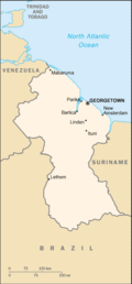
, with a land area of approximately 214,970 square kilometres. The country is situated between 1 and 9 north latitude and between 56 and 62 west longitude. With a 430-kilometre Atlantic coastline on the northeast, Guyana is bounded by Venezuela on the west, Brazil
Brazil
Brazil , officially the Federative Republic of Brazil , is the largest country in South America. It is the world's fifth largest country, both by geographical area and by population with over 192 million people...
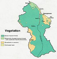
on the west and south, and Suriname on the east. The land comprises three main geographical zones: the coastal plain, the white sand belt, and the interior highlands.
Description
The coastal plain, which occupies about 5 percent of the country's area, is home to more than 90 percent of its inhabitants. The plain ranges from five to six kilometers wide and extends from the Courantyne RiverCourantyne River
The Corentyne / Courantyne / Corantijn River is a river in northern South America in the country of Suriname, it is the longest river in the state. The river originates in the Acarai Mountains and flows northward for approximately between Guyana and Suriname, emptying into the Atlantic Ocean near...
in the east to the Venezuelan border in the northwest.
The coastal plain is made up largely of alluvial mud swept out to sea by the Amazon River, carried north by ocean currents, and deposited on the Guyanese shores. A rich clay of great fertility, this mud overlays the white sands and clays formed from the erosion of the interior bedrock and carried seaward by the rivers of Guyana. Because much of the coastal plain floods at high tide, efforts to dam and drain this area have gone on since the 18th century.
Guyana has no well-defined shoreline or sandy beaches. Approaching the ocean, the land gradually loses elevation until it includes many areas of marsh and swamp. Seaward from the vegetation line is a region of mud flats, shallow brown water, and sandbars. Off New Amsterdam, these mud flats extend almost 25 kilometres (15.5 mi). The sandbars and shallow water are a major impediment to shipping, and incoming vessels must partially unload their cargoes offshore in order to reach the docks at Georgetown
Georgetown, Guyana
Georgetown, estimated population 239,227 , is the capital and largest city of Guyana, located in the Demerara-Mahaica region. It is situated on the Atlantic Ocean coast at the mouth of the Demerara River and it was nicknamed 'Garden City of the Caribbean.' Georgetown is located at . The city serves...
and New Amsterdam
New Amsterdam, Guyana
New Amsterdam , located in the East Berbice-Corentyne Region, 62 miles from the capital, Georgetown, is one of the largest towns in Guyana. It is located four miles upriver from the Atlantic Ocean mouth of the Berbice River, on its eastern bank, immediately south of the Canje River...
.
A line of swamps forms a barrier between the white sandy hills of the interior and the coastal plain. These swamps, formed when water was prevented from flowing onto coastal croplands by a series of dams, serve as reservoirs during periods of drought.
The white sand belt lies south of the coastal zone. This area is 150 to 250 kilometers wide and consists of low sandy hills interspersed with rocky outcroppings. The white sands support a dense hardwood forest. These sands cannot support crops, and if the trees are removed erosion is rapid and severe. Most of Guyana's reserves of bauxite, gold, and diamonds are found in this region.
The largest of Guyana's three geographical regions is the interior highlands, a series of plateaus, flat-topped mountains, and savannahs that extend from the white sand belt to the country's southern borders. The Pacaraima Mountains
Pacaraima Mountains
The Pacaraima or Pakaraima Mountains are the mountains of Guyana, lying in southwestern part of this country and shares borders with Brazil, Guyana, and Venezuela, extending from west to east for over . Its highest peak is Mount Roraima at above sea level, surrounded by cliffs high....
dominate the western part of the interior highlands. In this region are found some of the oldest sedimentary rocks in the Western Hemisphere. Mount Roraima, on the Venezuelan border, is part of the Pakaraima range and, at 2,762 meters, is Guyana's tallest peak. Farther south lies the Kaieteur Plateau, a broad, rocky area about 600 meters in elevation; the 1,000-meter high Kanuku Mountains
Kanuku Mountains
The Kanuku Mountains are a group of mountains in Guyana, located in the Upper Takutu-Upper Essequibo region. The name means 'forest' in the Wapishana language, a reference to the rich diversity of wildlife found there...
; and the low Acarai Mountains
Acarai Mountains
The Acarai Mountains are a wet, forested highland region of low mountains located in the southern part of Guyana. This range lies along the common border between Guyana and Brazil. The Acarai Mountains is one of four mountain ranges in Guyana, the others being the Imataka, Kanuku and Pakaraima...
situated on the southern border with Brazil.
Much of the interior highlands consist of grassland. The largest expanse of grassland, the Rupununi Savannah, covers about 15,000 square kilometers in southern Guyana. This savannah also extends far into Venezuela and Brazil. The part in Guyana is split into northern and southern regions by the Kanuku Mountains. The sparse grasses of the savannah in general support only grazing, although Amerindian groups cultivate a few areas along the Rupununi River and in the foothills of the Kanuku Mountains.
Hydrology
Essequibo River
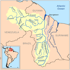
The Esequibo River is the largest river in Guyana, and the largest river between the Orinoco and Amazon. Rising in the Acarai Mountains near the Brazil-Guyana border, the Essequibo flows to the north for 1,010 km through forest and savanna into the Atlantic Ocean.-Geography:There are countless...
, draining the Kaieteur Plateau. The Essequibo, the country's major river, runs from the Brazilian border in the south to a wide delta west of Georgetown. The rivers of eastern Guyana cut across the coastal zone, making east-west travel difficult, but they also provide limited water access to the interior. Waterfalls generally limit water transport to the lower reaches of each river. Some of the waterfalls are spectacular; for example, Kaieteur Falls
Kaieteur Falls
Kaieteur Falls is a high-volume waterfall on the Potaro River in central Guyana, Potaro-Siparuni region. It is located inKaieteur National Park. It is 226 meters high when measured from its plunge over a sandstone and conglomerate cliff to the first break...
on the Potaro River
Potaro River
The Potaro River is a river in Guyana in northern South America.The source of the Potaro River is in the Mount Ayanganna area of the Pakaraima Mountains in the North Rupununi Savannahs...
drops 227 metres, more than four times the height of Niagara Falls
Niagara Falls
The Niagara Falls, located on the Niagara River draining Lake Erie into Lake Ontario, is the collective name for the Horseshoe Falls and the adjacent American Falls along with the comparatively small Bridal Veil Falls, which combined form the highest flow rate of any waterfalls in the world and has...
.
See also :Category:Rivers of Guyana, :Category:Waterfalls of Guyana.
Drainage throughout most of Guyana is poor and river flow sluggish because the average gradient of the main rivers is only one meter every five kilometers. Swamps and areas of periodic flooding are found in all but the mountainous regions, and all new land projects require extensive drainage networks before they are suitable for agricultural use. The average square kilometer on a sugar plantation, for example, has six kilometers of irrigation canals, eighteen kilometers of large drains, and eighteen kilometers of small drains. These canals occupy nearly one-eighth of the surface area of the average sugarcane field. Some of the larger estates have more than 550 kilometers of canals; Guyana itself has a total of more than 8,000 kilometers. Even Georgetown is below sea level and must depend on dikes for protection from the Demerara River
Demerara River
The Demerara River is a river in eastern Guyana that rises in the central rainforests of the country and flows to the north for 346 kilometres until it reaches the Atlantic Ocean. Georgetown, Guyana's largest seaport and capital, is situated on the east bank of the river's mouth. The Demerara's...
and the Atlantic Ocean.
Climate
Equator
An equator is the intersection of a sphere's surface with the plane perpendicular to the sphere's axis of rotation and containing the sphere's center of mass....
, Guyana has a tropical climate
Tropical climate
A tropical climate is a climate of the tropics. In the Köppen climate classification it is a non-arid climate in which all twelve months have mean temperatures above...
, and temperatures do not vary much throughout the year. The year has two wet season
Wet season
The the wet season, or rainy season, is the time of year, covering one or more months, when most of the average annual rainfall in a region occurs. The term green season is also sometimes used as a euphemism by tourist authorities. Areas with wet seasons are dispersed across portions of the...
s, from December to early February and from late April to mid-August.
Although the temperature never gets dangerously high, the combination of heat and humidity can at times seem oppressive. The entire area is under the influence of the northeast trade winds, and during the midday and afternoon sea breezes bring relief to the coast. Guyana lies south of the path of Caribbean hurricanes and none is known to have hit the country.
Temperatures in Georgetown
Georgetown, Guyana
Georgetown, estimated population 239,227 , is the capital and largest city of Guyana, located in the Demerara-Mahaica region. It is situated on the Atlantic Ocean coast at the mouth of the Demerara River and it was nicknamed 'Garden City of the Caribbean.' Georgetown is located at . The city serves...
are quite constant, with an average high of 32 °C (89.6 °F) and an average low of 24 °C (75.2 °F) in the hottest month (July), and an average range of 29 to 23 °C (84.2 to 73.4 °F) in February, the coolest month. The highest temperature ever recorded in the capital was 37.7 °C (99.9 °F) and the lowest 16.6 °C (61.9 °F). Humidity averages 70 percent year-round. Locations in the interior, away from the moderating influence of the ocean, experience slightly wider variations in daily temperature, and nighttime readings as low as 12 °C (53.6 °F) have been recorded. Humidity in the interior is also slightly lower, averaging around 60 percent.
Rainfall is heaviest in the northwest and lightest in the southeast and interior. Annual averages on the coast near the Venezuelan border are near 2500 millimetres (98.4 in), farther east at New Amsterdam
New Amsterdam, Guyana
New Amsterdam , located in the East Berbice-Corentyne Region, 62 miles from the capital, Georgetown, is one of the largest towns in Guyana. It is located four miles upriver from the Atlantic Ocean mouth of the Berbice River, on its eastern bank, immediately south of the Canje River...
, between 2000 and 1500 mm (78.7 and 59.1 in) in southern Guyana's Rupununi Savannah
Rupununi savannah
The Rupununi savannah is a savanna plain in Guyana, in the Upper Takutu-Upper Essequibo region. It is an ecoregion of the Tropical and subtropical grasslands, savannas, and shrublands Biome.-Description:...
. Areas on the northeast sides of mountains that catch the trade winds average as much as 3500 millimetres (137.8 in) of precipitation annually. Although rain falls throughout the year, about 50 percent of the annual total arrives in the summer rainy season that extends from May to the end of July along the coast and from April through September farther inland. Coastal areas have a second rainy season from November through January. Rain generally falls in heavy afternoon showers or thunderstorms. Overcast days are rare; most days include four to eight hours of sunshine from morning through early afternoon.
Characteristics
Geographic coordinates:5°00′N 59°00′W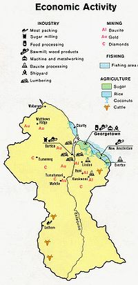
Land boundaries
- Total: 2,462 km
- Border countries: BrazilBrazilBrazil , officially the Federative Republic of Brazil , is the largest country in South America. It is the world's fifth largest country, both by geographical area and by population with over 192 million people...
1,119 km, Suriname 600 km, Venezuela 743 km
Maritime claims
- Continental shelf: 200 nmi (370.4 km; 230.2 mi) or to the outer edge of the continental margin
- Exclusive fishing zone: 200 nmi (370.4 km; 230.2 mi)
- Territorial sea: 12 nmi (22.2 km; 13.8 mi)
Elevation extremes
- Lowest point: Atlantic Ocean, 0 m
- Highest point: Mount Roraima, 2,835 m
Natural resources
BauxiteBauxite
Bauxite is an aluminium ore and is the main source of aluminium. This form of rock consists mostly of the minerals gibbsite Al3, boehmite γ-AlO, and diaspore α-AlO, in a mixture with the two iron oxides goethite and hematite, the clay mineral kaolinite, and small amounts of anatase TiO2...
, gold
Gold
Gold is a chemical element with the symbol Au and an atomic number of 79. Gold is a dense, soft, shiny, malleable and ductile metal. Pure gold has a bright yellow color and luster traditionally considered attractive, which it maintains without oxidizing in air or water. Chemically, gold is a...
, diamonds, hardwood timber, shrimp
Shrimp
Shrimp are swimming, decapod crustaceans classified in the infraorder Caridea, found widely around the world in both fresh and salt water. Adult shrimp are filter feeding benthic animals living close to the bottom. They can live in schools and can swim rapidly backwards. Shrimp are an important...
, fish
Fish
Fish are a paraphyletic group of organisms that consist of all gill-bearing aquatic vertebrate animals that lack limbs with digits. Included in this definition are the living hagfish, lampreys, and cartilaginous and bony fish, as well as various extinct related groups...
.
Land use
- Arable land: 2%
- Permanent crops: 0%
- Permanent pastures: 6%
- Forests and woodland: 84%
- Other: 8% (1993 est.)
Environment, current issues
- Water pollution from sewage and agricultural and industrial chemicals; deforestation
Environment - international agreements
Party to: BiodiversityBiodiversity
Biodiversity is the degree of variation of life forms within a given ecosystem, biome, or an entire planet. Biodiversity is a measure of the health of ecosystems. Biodiversity is in part a function of climate. In terrestrial habitats, tropical regions are typically rich whereas polar regions...
, Climate Change
United Nations Framework Convention on Climate Change
The United Nations Framework Convention on Climate Change is an international environmental treaty produced at the United Nations Conference on Environment and Development , informally known as the Earth Summit, held in Rio de Janeiro from June 3 to 14, 1992...
, Desertification
Desertification
Desertification is the degradation of land in drylands. Caused by a variety of factors, such as climate change and human activities, desertification is one of the most significant global environmental problems.-Definitions:...
, Endangered Species
Endangered species
An endangered species is a population of organisms which is at risk of becoming extinct because it is either few in numbers, or threatened by changing environmental or predation parameters...
, Law of the Sea
Law of the sea
Law of the sea may refer to:* United Nations Convention on the Law of the Sea* Admiralty law* The Custom of the Sea...
, Ozone Layer Protection, Ship Pollution, Tropical Timber 83, Tropical Timber 94