

Geography of Guinea-Bissau
Encyclopedia
Guinea-Bissau
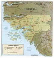
The Republic of Guinea-Bissau is a country in West Africa. It is bordered by Senegal to the north, and Guinea to the south and east, with the Atlantic Ocean to its west....
.
Climate
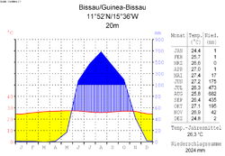
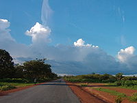
Guinea-Bissau is warm all year around and there is little temperature fluctuation; it averages 26.3 °C (79.3 °F). The average rainfall for Bissau is 2024 millimetres (79.7 in) although this is almost entirely accounted for during the rainy season which falls between June and September/October. From December through April, the country experiences drought
Drought
A drought is an extended period of months or years when a region notes a deficiency in its water supply. Generally, this occurs when a region receives consistently below average precipitation. It can have a substantial impact on the ecosystem and agriculture of the affected region...
.
Terrain and ecology
The terrain of Guinea-Bissau is mostly low coastal plain with swamps of Guinean mangrovesGuinean mangroves
The Guinean mangroves are a coastal ecoregion of mangrove swamps in rivers and estuaries near the ocean of West Africa from Senegal to Sierra Leone.-Location and description:...
rising to Guinean forest-savanna mosaic
Guinean forest-savanna mosaic
The Guinean forest-savanna mosaic is an ecoregion of West Africa, a band of interlaced forest, savanna, and grassland running east to west and dividing the tropical moist forests near the coast from the West Sudanian savanna of the interior.-Setting:...
in the east.
The lowest point on Guinea-Bissau is at sea level at the Atlantic Ocean. The highest point on Guinea-Bissau is 300 metres above sea level at an unnamed location in the northeast corner of the country.
Natural resources found in Guinea-Bissau include fish, timber, phosphates, bauxite
Bauxite
Bauxite is an aluminium ore and is the main source of aluminium. This form of rock consists mostly of the minerals gibbsite Al3, boehmite γ-AlO, and diaspore α-AlO, in a mixture with the two iron oxides goethite and hematite, the clay mineral kaolinite, and small amounts of anatase TiO2...
, clay, granite, limestone and unexploited deposits of petroleum. 8.31% of the land is arable and 250 square kilometres is irrigated. Natural hazards include a hot, dry, dusty harmattan
Harmattan
The Harmattan is a dry and dusty West African trade wind. It blows south from the Sahara into the Gulf of Guinea between the end of November and the middle of March...
haze that may reduce visibility during the dry season and brush fires. Severe environmental issues include deforestation; soil erosion; overgrazing and overfishing.
Near the Senegal border there have been historic sightings of the Painted Hunting Dog, Lycaon pictus, but that endangered canid may now be extirpated in that locale.
Information from the CIA World Factbook
LocationLocation (geography)
The terms location and place in geography are used to identify a point or an area on the Earth's surface or elsewhere. The term 'location' generally implies a higher degree of can certainty than "place" which often has an ambiguous boundary relying more on human/social attributes of place identity...
:
- Western AfricaAfricaAfrica is the world's second largest and second most populous continent, after Asia. At about 30.2 million km² including adjacent islands, it covers 6% of the Earth's total surface area and 20.4% of the total land area...
, bordering the North Atlantic OceanAtlantic OceanThe Atlantic Ocean is the second-largest of the world's oceanic divisions. With a total area of about , it covers approximately 20% of the Earth's surface and about 26% of its water surface area...
, between GuineaGuineaGuinea , officially the Republic of Guinea , is a country in West Africa. Formerly known as French Guinea , it is today sometimes called Guinea-Conakry to distinguish it from its neighbour Guinea-Bissau. Guinea is divided into eight administrative regions and subdivided into thirty-three prefectures...
and SenegalSenegalSenegal , officially the Republic of Senegal , is a country in western Africa. It owes its name to the Sénégal River that borders it to the east and north...
Geographic coordinates:
- 12°00′N 15°00′W
Map references
Area:
- Total: 36,120 km²
- Land: 28,000 km²
- Water: 8,120 km²
Area—comparative:
- Slightly less than three times the size of ConnecticutConnecticutConnecticut is a state in the New England region of the northeastern United States. It is bordered by Rhode Island to the east, Massachusetts to the north, and the state of New York to the west and the south .Connecticut is named for the Connecticut River, the major U.S. river that approximately...
Land boundaries:
- Total: 724 km
- Border countries: Guinea 386 km, Senegal 338 km
Coastline:
- 350 km
Maritime claims:
- Exclusive economic zone: 200 nmi (370.4 km; 230.2 mi)
- Territorial sea: 12 nmi (22.2 km; 13.8 mi)
Terrain:
- Mostly low coastal plain rising to savannaSavannaA savanna, or savannah, is a grassland ecosystem characterized by the trees being sufficiently small or widely spaced so that the canopy does not close. The open canopy allows sufficient light to reach the ground to support an unbroken herbaceous layer consisting primarily of C4 grasses.Some...
in east
Elevation extremes:
- Lowest point: Atlantic Ocean 0 m
- Highest point: Unnamed location in the northeast corner of the country 300 m
Natural resources:
- FishFishFish are a paraphyletic group of organisms that consist of all gill-bearing aquatic vertebrate animals that lack limbs with digits. Included in this definition are the living hagfish, lampreys, and cartilaginous and bony fish, as well as various extinct related groups...
, timberTimberTimber may refer to:* Timber, a term common in the United Kingdom and Australia for wood materials * Timber, Oregon, an unincorporated community in the U.S...
, phosphates, bauxiteBauxiteBauxite is an aluminium ore and is the main source of aluminium. This form of rock consists mostly of the minerals gibbsite Al3, boehmite γ-AlO, and diaspore α-AlO, in a mixture with the two iron oxides goethite and hematite, the clay mineral kaolinite, and small amounts of anatase TiO2...
, unexploited deposits of petroleumPetroleumPetroleum or crude oil is a naturally occurring, flammable liquid consisting of a complex mixture of hydrocarbons of various molecular weights and other liquid organic compounds, that are found in geologic formations beneath the Earth's surface. Petroleum is recovered mostly through oil drilling...
Land use:
- Arable land: 11%
- Permanent crops: 1%
- Permanent pastures: 38%
- Forests and woodland: 38%
- Other: 12% (1993 est.)
Irrigated land:
- 17 km² (1993 est.)
Natural hazards:
- Hot, dry, dusty harmattan haze may reduce visibility during dry season; brush fires
Environment—current issues:
- Deforestation; soil erosion; overgrazing; overfishing
Environment—international agreements:
- Party to: BiodiversityBiodiversityBiodiversity is the degree of variation of life forms within a given ecosystem, biome, or an entire planet. Biodiversity is a measure of the health of ecosystems. Biodiversity is in part a function of climate. In terrestrial habitats, tropical regions are typically rich whereas polar regions...
, Climate ChangeUnited Nations Framework Convention on Climate ChangeThe United Nations Framework Convention on Climate Change is an international environmental treaty produced at the United Nations Conference on Environment and Development , informally known as the Earth Summit, held in Rio de Janeiro from June 3 to 14, 1992...
, DesertificationDesertificationDesertification is the degradation of land in drylands. Caused by a variety of factors, such as climate change and human activities, desertification is one of the most significant global environmental problems.-Definitions:...
, Endangered SpeciesEndangered speciesAn endangered species is a population of organisms which is at risk of becoming extinct because it is either few in numbers, or threatened by changing environmental or predation parameters...
, Law of the SeaLaw of the seaLaw of the sea may refer to:* United Nations Convention on the Law of the Sea* Admiralty law* The Custom of the Sea...
, Wetlands - Signed, but not ratified: None of the selected agreements https://www.cia.gov/library/publications/the-world-factbook/geos/pu.html
Extreme points
This is a list of the extreme points of Guinea-BissauGuinea-Bissau
The Republic of Guinea-Bissau is a country in West Africa. It is bordered by Senegal to the north, and Guinea to the south and east, with the Atlantic Ocean to its west....
, the points that are farther north, south, east or west than any other location.
- Northern-most point – the northern section of the border with SenegalSenegalSenegal , officially the Republic of Senegal , is a country in western Africa. It owes its name to the Sénégal River that borders it to the east and north...
* - Eastern-most point – unnamed location on the border with GuineaGuineaGuinea , officially the Republic of Guinea , is a country in West Africa. Formerly known as French Guinea , it is today sometimes called Guinea-Conakry to distinguish it from its neighbour Guinea-Bissau. Guinea is divided into eight administrative regions and subdivided into thirty-three prefectures...
immediately south-west of the Guinean village of Sofan, Gabú RegionGabú RegionGabú region is the eastern-most region in Guinea-Bissau. Its capital is Gabú. The region borders Senegal to the north, Guinea to the east and south and the Guinea-Bissau regions of Tombali and Bafatá to the east. It covers an area of 9,150 km2, making it the largest of Guinea-Bissau's... - Southern-most point – unnamed headland on Ilha Cataque, Tombali RegionTombali RegionTombali is a region in southern Guinea-Bissau. Its capital is Catió.Tombali is divided into 4 sectors:*Bedanda*Cacine*Catio*QueboSee also:*Regions of Guinea-Bissau*Sectors of Guinea-Bissau...
- Western-most point - Cap Roxo at the point where the border with SenegalSenegalSenegal , officially the Republic of Senegal , is a country in western Africa. It owes its name to the Sénégal River that borders it to the east and north...
enters the Atlantic OceanAtlantic OceanThe Atlantic Ocean is the second-largest of the world's oceanic divisions. With a total area of about , it covers approximately 20% of the Earth's surface and about 26% of its water surface area...
, Cacheu RegionCacheu RegionCacheu is a region in western Guinea-Bissau, on the border with Senegal. It has an area of 5,175 km2 and a population estimated in 2004 at 164,676. Its capital is Cacheu.Cacheu is divided into 6 administrative sectors:*Bigene*Bula*Cacheu*Caió...
- *Note: Guinea-Bissau does not have a northern-most point, the border here being formed by a straight horizontal line