

Geography of Guinea
Encyclopedia
Guinea
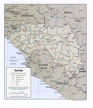
Guinea , officially the Republic of Guinea , is a country in West Africa. Formerly known as French Guinea , it is today sometimes called Guinea-Conakry to distinguish it from its neighbour Guinea-Bissau. Guinea is divided into eight administrative regions and subdivided into thirty-three prefectures...
Coast of West Africa and is bordered by Guinea-Bissau
Guinea-Bissau
The Republic of Guinea-Bissau is a country in West Africa. It is bordered by Senegal to the north, and Guinea to the south and east, with the Atlantic Ocean to its west....
, Senegal
Senegal
Senegal , officially the Republic of Senegal , is a country in western Africa. It owes its name to the Sénégal River that borders it to the east and north...
, Mali
Mali
Mali , officially the Republic of Mali , is a landlocked country in Western Africa. Mali borders Algeria on the north, Niger on the east, Burkina Faso and the Côte d'Ivoire on the south, Guinea on the south-west, and Senegal and Mauritania on the west. Its size is just over 1,240,000 km² with...
, Côte d'Ivoire
Côte d'Ivoire
The Republic of Côte d'Ivoire or Ivory Coast is a country in West Africa. It has an area of , and borders the countries Liberia, Guinea, Mali, Burkina Faso and Ghana; its southern boundary is along the Gulf of Guinea. The country's population was 15,366,672 in 1998 and was estimated to be...
, Liberia
Liberia
Liberia , officially the Republic of Liberia, is a country in West Africa. It is bordered by Sierra Leone on the west, Guinea on the north and Côte d'Ivoire on the east. Liberia's coastline is composed of mostly mangrove forests while the more sparsely populated inland consists of forests that open...
, and Sierra Leone
Sierra Leone
Sierra Leone , officially the Republic of Sierra Leone, is a country in West Africa. It is bordered by Guinea to the north and east, Liberia to the southeast, and the Atlantic Ocean to the west and southwest. Sierra Leone covers a total area of and has an estimated population between 5.4 and 6.4...
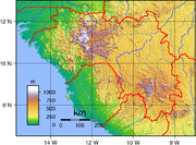
. The country is divided into four geographic regions: A lowland belt running north to south behind the coast (Lower Guinea
Lower Guinea
Lower Guinea can refer to the coastal part of either* the Republic of Guinea* the wider Guinea region-See also:*Lower Guinean forests*Middle Guinea*Upper Guinea...
), which is part of the Guinean forest-savanna mosaic
Guinean forest-savanna mosaic
The Guinean forest-savanna mosaic is an ecoregion of West Africa, a band of interlaced forest, savanna, and grassland running east to west and dividing the tropical moist forests near the coast from the West Sudanian savanna of the interior.-Setting:...
ecoregion; the pastoral Fouta Djallon
Fouta Djallon
Fouta Djallon is a highland region in the centre of Guinea, West Africa. The indigenous name is Fuuta-Jaloo...
highlands (Middle Guinea
Middle Guinea
Middle Guinea refers to the central part of the Republic of Guinea....
); the northern savanna
Savanna
A savanna, or savannah, is a grassland ecosystem characterized by the trees being sufficiently small or widely spaced so that the canopy does not close. The open canopy allows sufficient light to reach the ground to support an unbroken herbaceous layer consisting primarily of C4 grasses.Some...
(Upper Guinea
Upper Guinea
Upper Guinea or la Haute-Guinée is a large plain covering eastern Guinea, Sierra Leone, Liberia and extending into north western Côte d'Ivoire. Mostly forming the upper watershed of the River Niger, it is sparsely populated and is home to the Haut Niger National Park.Upper Guinea can also refer to...
); and a southeastern rain-forest region (Forest Guinea). The Niger, Gambia, and Senegal Rivers are among the 22 West African rivers that have their origins in Guinea.
Climate
The coastal region of Guinea and most of the inland have a tropical climate, with a rainy season lasting from April to November, relatively high and uniform temperatures, and high humidity. Conakry's year-round average high is 29 °C (84.2 °F), and the low is 23 °C (73.4 °F); its average annual rainfall is 4300 mm (169.3 in). Sahelian Upper Guinea has a shorter rainy season and greater daily temperature variations.General information
Location:Western Africa
Africa
Africa is the world's second largest and second most populous continent, after Asia. At about 30.2 million km² including adjacent islands, it covers 6% of the Earth's total surface area and 20.4% of the total land area...
, bordering the North Atlantic Ocean
Atlantic Ocean
The Atlantic Ocean is the second-largest of the world's oceanic divisions. With a total area of about , it covers approximately 20% of the Earth's surface and about 26% of its water surface area...
, between Guinea-Bissau
Guinea-Bissau
The Republic of Guinea-Bissau is a country in West Africa. It is bordered by Senegal to the north, and Guinea to the south and east, with the Atlantic Ocean to its west....
and Sierra Leone
Sierra Leone
Sierra Leone , officially the Republic of Sierra Leone, is a country in West Africa. It is bordered by Guinea to the north and east, Liberia to the southeast, and the Atlantic Ocean to the west and southwest. Sierra Leone covers a total area of and has an estimated population between 5.4 and 6.4...
Geographic coordinates:
11°00′N 10°00′W
Map references:
Africa
Area:
total:
245,857 km²
land:
245,857 km²
water:
0 km²
Area - comparative:
slightly smaller than Oregon
Oregon
Oregon is a state in the Pacific Northwest region of the United States. It is located on the Pacific coast, with Washington to the north, California to the south, Nevada on the southeast and Idaho to the east. The Columbia and Snake rivers delineate much of Oregon's northern and eastern...
Land boundaries:
- total:
3,399 km
- border countries:
Côte d'Ivoire
Côte d'Ivoire
The Republic of Côte d'Ivoire or Ivory Coast is a country in West Africa. It has an area of , and borders the countries Liberia, Guinea, Mali, Burkina Faso and Ghana; its southern boundary is along the Gulf of Guinea. The country's population was 15,366,672 in 1998 and was estimated to be...
610 km, Guinea-Bissau
Guinea-Bissau
The Republic of Guinea-Bissau is a country in West Africa. It is bordered by Senegal to the north, and Guinea to the south and east, with the Atlantic Ocean to its west....
386 km, Liberia
Liberia
Liberia , officially the Republic of Liberia, is a country in West Africa. It is bordered by Sierra Leone on the west, Guinea on the north and Côte d'Ivoire on the east. Liberia's coastline is composed of mostly mangrove forests while the more sparsely populated inland consists of forests that open...
563 km, Mali
Mali
Mali , officially the Republic of Mali , is a landlocked country in Western Africa. Mali borders Algeria on the north, Niger on the east, Burkina Faso and the Côte d'Ivoire on the south, Guinea on the south-west, and Senegal and Mauritania on the west. Its size is just over 1,240,000 km² with...
858 km, Senegal
Senegal
Senegal , officially the Republic of Senegal , is a country in western Africa. It owes its name to the Sénégal River that borders it to the east and north...
330 km, Sierra Leone
Sierra Leone
Sierra Leone , officially the Republic of Sierra Leone, is a country in West Africa. It is bordered by Guinea to the north and east, Liberia to the southeast, and the Atlantic Ocean to the west and southwest. Sierra Leone covers a total area of and has an estimated population between 5.4 and 6.4...
652 km
Coastline:
320 km
Maritime claims:
exclusive economic zone
Exclusive Economic Zone
Under the law of the sea, an exclusive economic zone is a seazone over which a state has special rights over the exploration and use of marine resources, including production of energy from water and wind. It stretches from the seaward edge of the state's territorial sea out to 200 nautical...
:
200 nmi (370.4 km; 230.2 mi)
territorial sea:
12 nmi (22.2 km; 13.8 mi)
Climate:
generally hot and humid; monsoon
Monsoon
Monsoon is traditionally defined as a seasonal reversing wind accompanied by corresponding changes in precipitation, but is now used to describe seasonal changes in atmospheric circulation and precipitation associated with the asymmetric heating of land and sea...
al-type rainy season (June to November) with southwesterly winds; dry season (December to May) with northeasterly harmattan
Harmattan
The Harmattan is a dry and dusty West African trade wind. It blows south from the Sahara into the Gulf of Guinea between the end of November and the middle of March...
winds
Terrain:
generally flat coastal plain, hilly to mountainous interior
Elevation extremes:
lowest point:
Atlantic Ocean 0 m
highest point:
Mont Nimba 1,752 m
Natural resources:
bauxite
Bauxite
Bauxite is an aluminium ore and is the main source of aluminium. This form of rock consists mostly of the minerals gibbsite Al3, boehmite γ-AlO, and diaspore α-AlO, in a mixture with the two iron oxides goethite and hematite, the clay mineral kaolinite, and small amounts of anatase TiO2...
, iron ore, diamond
Diamond
In mineralogy, diamond is an allotrope of carbon, where the carbon atoms are arranged in a variation of the face-centered cubic crystal structure called a diamond lattice. Diamond is less stable than graphite, but the conversion rate from diamond to graphite is negligible at ambient conditions...
s, gold
Gold
Gold is a chemical element with the symbol Au and an atomic number of 79. Gold is a dense, soft, shiny, malleable and ductile metal. Pure gold has a bright yellow color and luster traditionally considered attractive, which it maintains without oxidizing in air or water. Chemically, gold is a...
, uranium
Uranium
Uranium is a silvery-white metallic chemical element in the actinide series of the periodic table, with atomic number 92. It is assigned the chemical symbol U. A uranium atom has 92 protons and 92 electrons, of which 6 are valence electrons...
, hydropower, fish
Land use:
arable land:
2%
permanent crops:
0%
permanent pastures:
22%
forests and woodland:
59%
other:
17% (1993 est.)
Irrigated land:
930 km² (1993 est.)
Natural hazards:
hot, dry, dusty harmattan haze may reduce visibility during dry season
Environment - current issues:
deforestation
Deforestation
Deforestation is the removal of a forest or stand of trees where the land is thereafter converted to a nonforest use. Examples of deforestation include conversion of forestland to farms, ranches, or urban use....
; inadequate supplies of potable water; desertification
Desertification
Desertification is the degradation of land in drylands. Caused by a variety of factors, such as climate change and human activities, desertification is one of the most significant global environmental problems.-Definitions:...
; soil contamination and erosion; overfishing, overpopulation
Overpopulation
Overpopulation is a condition where an organism's numbers exceed the carrying capacity of its habitat. The term often refers to the relationship between the human population and its environment, the Earth...
in forest region
Environment - international agreements:
party to:
Biodiversity, Climate Change, Desertification, Endangered Species, Hazardous Wastes, Law of the Sea, Ozone Layer Protection, Wetlands
signed, but not ratified:
none of the selected agreements
Extreme points
This is a list of the extreme points of GuineaGuinea
Guinea , officially the Republic of Guinea , is a country in West Africa. Formerly known as French Guinea , it is today sometimes called Guinea-Conakry to distinguish it from its neighbour Guinea-Bissau. Guinea is divided into eight administrative regions and subdivided into thirty-three prefectures...
, the points that are farther north, south, east or west than any other location.
- Northern-most point – the northern section of the border with SenegalSenegalSenegal , officially the Republic of Senegal , is a country in western Africa. It owes its name to the Sénégal River that borders it to the east and north...
, Boké RegionBoké RegionThe Boké Region is located in western Guinea. It is bordered by the countries of Senegal and Guinea-Bissau and the Guinean regions of Kindia and Labé...
* - Eastern-most point – the confluenceConfluenceConfluence, in geography, describes the meeting of two or more bodies of water.Confluence may also refer to:* Confluence , a property of term rewriting systems...
of the Gben river and the Férédougouba river on the border with Cote d'IvoireCôte d'IvoireThe Republic of Côte d'Ivoire or Ivory Coast is a country in West Africa. It has an area of , and borders the countries Liberia, Guinea, Mali, Burkina Faso and Ghana; its southern boundary is along the Gulf of Guinea. The country's population was 15,366,672 in 1998 and was estimated to be...
, Nzérékoré RegionNzérékoré RegionThe Nzérékoré Region is a region in the southern part of Guinea. Its capital and largest city is Nzérékoré. It is one of the eight regions of Guinea... - Southern-most point – unnamed location on the border with LiberiaLiberiaLiberia , officially the Republic of Liberia, is a country in West Africa. It is bordered by Sierra Leone on the west, Guinea on the north and Côte d'Ivoire on the east. Liberia's coastline is composed of mostly mangrove forests while the more sparsely populated inland consists of forests that open...
immediately south of the village of Gonon, Nzérékoré RegionNzérékoré RegionThe Nzérékoré Region is a region in the southern part of Guinea. Its capital and largest city is Nzérékoré. It is one of the eight regions of Guinea... - Western-most point - Ile du Noufrage, Boké RegionBoké RegionThe Boké Region is located in western Guinea. It is bordered by the countries of Senegal and Guinea-Bissau and the Guinean regions of Kindia and Labé...
- Western-most point (mainland) - the point at which the border with Guinea-BissauGuinea-BissauThe Republic of Guinea-Bissau is a country in West Africa. It is bordered by Senegal to the north, and Guinea to the south and east, with the Atlantic Ocean to its west....
enters the Rio Compony estuary
- *Note: Guinea does not have a northern-most point, this section of the border being formed by a straight horizontal line
See also
- GuineaGuineaGuinea , officially the Republic of Guinea , is a country in West Africa. Formerly known as French Guinea , it is today sometimes called Guinea-Conakry to distinguish it from its neighbour Guinea-Bissau. Guinea is divided into eight administrative regions and subdivided into thirty-three prefectures...