
Geography of Guatemala
Encyclopedia
|
||
| Continent Continent A continent is one of several very large landmasses on Earth. They are generally identified by convention rather than any strict criteria, with seven regions commonly regarded as continents—they are : Asia, Africa, North America, South America, Antarctica, Europe, and Australia.Plate tectonics is... |
North America North America North America is a continent wholly within the Northern Hemisphere and almost wholly within the Western Hemisphere. It is also considered a northern subcontinent of the Americas... |
|
| Subregion Subregion A subregion is a conceptual unit which derives from a larger region or continent and is usually based on location. Cardinal directions, such as south or southern, are commonly used to define a subregion.- United Nations subregions :... |
Central America Central America Central America is the central geographic region of the Americas. It is the southernmost, isthmian portion of the North American continent, which connects with South America on the southeast. When considered part of the unified continental model, it is considered a subcontinent... |
|
| Geographic coordinates | 15°30′N 90°15′W | |
| Area Area Area is a quantity that expresses the extent of a two-dimensional surface or shape in the plane. Area can be understood as the amount of material with a given thickness that would be necessary to fashion a model of the shape, or the amount of paint necessary to cover the surface with a single coat... - Total - Water |
Ranked 106th 108,890 km² approx. 950 km² |
|
| Coastline | 400 km | |
| Land boundaries | 1,687 km | |
| Countries bordered | Mexico Mexico The United Mexican States , commonly known as Mexico , is a federal constitutional republic in North America. It is bordered on the north by the United States; on the south and west by the Pacific Ocean; on the southeast by Guatemala, Belize, and the Caribbean Sea; and on the east by the Gulf of... , 962 km Belize Belize Belize is a constitutional monarchy and the northernmost country in Central America. Belize has a diverse society, comprising many cultures and languages. Even though Kriol and Spanish are spoken among the population, Belize is the only country in Central America where English is the official... , 266 km El Salvador El Salvador El Salvador or simply Salvador is the smallest and the most densely populated country in Central America. The country's capital city and largest city is San Salvador; Santa Ana and San Miguel are also important cultural and commercial centers in the country and in all of Central America... , 203 km Honduras Honduras Honduras is a republic in Central America. It was previously known as Spanish Honduras to differentiate it from British Honduras, which became the modern-day state of Belize... , 256 km |
|
| Maritime claims | 200 nmi (370.4 km; 230.2 mi) | |
| Highest point | Tajumulco volcano Volcán Tajumulco Volcán Tajumulco is a large stratovolcano in the department of San Marcos in western Guatemala. It is the highest mountain in Guatemala and Central America at... , 4,220 m |
|
| Lowest point | Pacific Ocean Pacific Ocean The Pacific Ocean is the largest of the Earth's oceanic divisions. It extends from the Arctic in the north to the Southern Ocean in the south, bounded by Asia and Australia in the west, and the Americas in the east.At 165.2 million square kilometres in area, this largest division of the World... , 0 m |
|
| Longest river | Motagua River Motagua River The Motagua River is a long river in Guatemala. It rises in the western highlands of Guatemala where it is also called Río Grande, and runs in an easterly direction to the Gulf of Honduras. The final few kilometres of the river form part of the Guatemala/Honduras border... , 486 km |
|
| Largest inland body of water | Lake Izabal Lake Izabal Lago de Izabal, also known as the Golfo Dulce, is the largest lake in Guatemala with a surface area of 589.6 km² and a maximum depth is 18 meters . The Polochic River is the largest river that drains into the lake... 589.6 km² |
|
| Land Use - Arable land - Permanent crops - Permanent pastures - Forests and woodlands - Other |
12 % 5 % 24 % 54 % 5 % (1993 est.) |
|
| Climate Climate Climate encompasses the statistics of temperature, humidity, atmospheric pressure, wind, rainfall, atmospheric particle count and other meteorological elemental measurements in a given region over long periods... : |
Tropical to temperate Temperate In geography, temperate or tepid latitudes of the globe lie between the tropics and the polar circles. The changes in these regions between summer and winter are generally relatively moderate, rather than extreme hot or cold... |
|
| Terrain Terrain Terrain, or land relief, is the vertical and horizontal dimension of land surface. When relief is described underwater, the term bathymetry is used... : |
plain Plain In geography, a plain is land with relatively low relief, that is flat or gently rolling. Prairies and steppes are types of plains, and the archetype for a plain is often thought of as a grassland, but plains in their natural state may also be covered in shrublands, woodland and forest, or... s, mountain Mountain Image:Himalaya_annotated.jpg|thumb|right|The Himalayan mountain range with Mount Everestrect 58 14 160 49 Chomo Lonzorect 200 28 335 52 Makalurect 378 24 566 45 Mount Everestrect 188 581 920 656 Tibetan Plateaurect 250 406 340 427 Rong River... s |
|
| Natural resources | petroleum Petroleum Petroleum or crude oil is a naturally occurring, flammable liquid consisting of a complex mixture of hydrocarbons of various molecular weights and other liquid organic compounds, that are found in geologic formations beneath the Earth's surface. Petroleum is recovered mostly through oil drilling... , nickel Nickel Nickel is a chemical element with the chemical symbol Ni and atomic number 28. It is a silvery-white lustrous metal with a slight golden tinge. Nickel belongs to the transition metals and is hard and ductile... , rare woods, fish Fish Fish are a paraphyletic group of organisms that consist of all gill-bearing aquatic vertebrate animals that lack limbs with digits. Included in this definition are the living hagfish, lampreys, and cartilaginous and bony fish, as well as various extinct related groups... , wildlife Wildlife Wildlife includes all non-domesticated plants, animals and other organisms. Domesticating wild plant and animal species for human benefit has occurred many times all over the planet, and has a major impact on the environment, both positive and negative.... , hydropower Hydropower Hydropower, hydraulic power, hydrokinetic power or water power is power that is derived from the force or energy of falling water, which may be harnessed for useful purposes. Since ancient times, hydropower has been used for irrigation and the operation of various mechanical devices, such as... |
|
| Natural hazards | earthquake Earthquake An earthquake is the result of a sudden release of energy in the Earth's crust that creates seismic waves. The seismicity, seismism or seismic activity of an area refers to the frequency, type and size of earthquakes experienced over a period of time... s, volcanic eruptions, flood Flood A flood is an overflow of an expanse of water that submerges land. The EU Floods directive defines a flood as a temporary covering by water of land not normally covered by water... ings, landslide Landslide A landslide or landslip is a geological phenomenon which includes a wide range of ground movement, such as rockfalls, deep failure of slopes and shallow debris flows, which can occur in offshore, coastal and onshore environments... s |
|
| Environmental issues | deforestation Deforestation Deforestation is the removal of a forest or stand of trees where the land is thereafter converted to a nonforest use. Examples of deforestation include conversion of forestland to farms, ranches, or urban use.... , air Air pollution Air pollution is the introduction of chemicals, particulate matter, or biological materials that cause harm or discomfort to humans or other living organisms, or cause damage to the natural environment or built environment, into the atmosphere.... and water pollution Water pollution Water pollution is the contamination of water bodies . Water pollution occurs when pollutants are discharged directly or indirectly into water bodies without adequate treatment to remove harmful compounds.... |
|
Guatemala
Guatemala
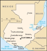
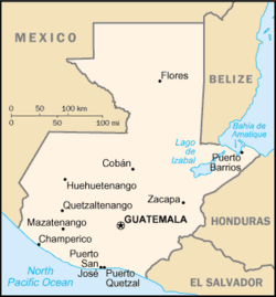
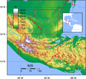
Guatemala is a country in Central America bordered by Mexico to the north and west, the Pacific Ocean to the southwest, Belize to the northeast, the Caribbean to the east, and Honduras and El Salvador to the southeast...
is mountainous, except for the south coastal area and the northern vast lowlands of Petén
Petén (department)
Petén is a department of the nation of Guatemala. It is geographically the northernmost department of Guatemala, as well as the largest in size — at it accounts for about one third of Guatemala's area. The capital is Flores...
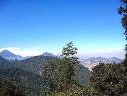
department. Two mountain chains enter Guatemala from west to east, dividing the country into three major regions: the highlands
Guatemalan Highlands
The Guatemalan Highlands is an upland region in southern Guatemala, lying between the Sierra Madre de Chiapas to the south and the Petén lowlands to the north....
, where the mountains are located; the Pacific coast, south of the mountains; and the Petén region, north of the mountains. These areas vary in climate, elevation, and landscape, providing dramatic contrasts between hot and humid tropical lowlands and highland peaks and valleys.
Overview
Guatemalan Highlands
The Guatemalan Highlands is an upland region in southern Guatemala, lying between the Sierra Madre de Chiapas to the south and the Petén lowlands to the north....
is marked by the Sierra Madre
Sierra Madre de Chiapas
Sierra Madre is a mountain range which runs northwest-southeast from the state of Chiapas in Mexico across Guatemala and into El Salvador and Honduras. Most of the volcanoes of Guatemala are a part of this range.A narrow coastal plain lies south the range, between the Sierra Madre and the Pacific...
, which stretches from the Mexican border south and east, and continues at lower elevations toward El Salvador
El Salvador
El Salvador or simply Salvador is the smallest and the most densely populated country in Central America. The country's capital city and largest city is San Salvador; Santa Ana and San Miguel are also important cultural and commercial centers in the country and in all of Central America...
. The mountain chain is characterized by steep volcanic cones, including Tajumulco Volcano
Volcán Tajumulco
Volcán Tajumulco is a large stratovolcano in the department of San Marcos in western Guatemala. It is the highest mountain in Guatemala and Central America at...
(4220 m (13,845 ft), the highest point in the country and Central America
Central America
Central America is the central geographic region of the Americas. It is the southernmost, isthmian portion of the North American continent, which connects with South America on the southeast. When considered part of the unified continental model, it is considered a subcontinent...
. All of Guatemala’s 37 volcanoes (4 of them active Pacaya
Pacaya
Pacaya is an active complex volcano in Guatemala, which first erupted approximately 23,000 years ago and has erupted at least 23 times since the Spanish conquest of Guatemala. Pacaya rises to an elevation of . After being dormant for a century, it erupted violently in 1965 and has been...
, Santiaguito, Fuego
Fuego
- Places :*Volcán de Fuego, strato volcano in Guatemala*Tierra del Fuego, island in South America MAGALING SYA- Music :*Fuego Miguel Duran Jr, A Dominican American Merengue Singer-songwrite...
and Tacaná
Tacaná
Tacaná is a municipality in the Guatemalan department of San Marcos....
), are in this mountain chain, and are frequent in the highlands.
The northern chain of mountains begins near the Mexican border with the Cuchumatanes range, then stretches east through the Chuacús
Sierra de Chuacús
The Sierra de Chuacús is situated in the central highlands of Guatemala, and runs southeast from El Quiché to Baja Verapaz. Its northwestern border is marked by the Chixoy River basin in Uspantán, which separates it from the Sierra de los Cuchumatanes. Its eastern border is marked by the Salamá...
and Chamá sierras, down to the Santa Cruz
Sierra de Santa Cruz (Guatemala)
The Sierra de Santa Cruz is a small mountain range in eastern Guatemala. It is situated north of Lake Izabal, in the department of Izabal. The mountain range has a south-west to north-east orientation, and is approximately 55 km long and 13 km wide....
and Minas
Sierra de las Minas
Sierra de las Minas is a mountain range in eastern Guatemala, extending 130 km west of the Lake Izabal. It is 15–30 km wide and bordered by the valleys of the rivers Polochic in the north and the Motagua in the south. Its western border is marked by the Salamá River valley which separates it...
sierras, near the Caribbean Sea
Caribbean Sea
The Caribbean Sea is a sea of the Atlantic Ocean located in the tropics of the Western hemisphere. It is bounded by Mexico and Central America to the west and southwest, to the north by the Greater Antilles, and to the east by the Lesser Antilles....
. The northern and southern mountains are separated by the Motagua valley, where the Motagua river
Motagua River
The Motagua River is a long river in Guatemala. It rises in the western highlands of Guatemala where it is also called Río Grande, and runs in an easterly direction to the Gulf of Honduras. The final few kilometres of the river form part of the Guatemala/Honduras border...
and its tributaries drains from the highlands into the Caribbean
Caribbean
The Caribbean is a crescent-shaped group of islands more than 2,000 miles long separating the Gulf of Mexico and the Caribbean Sea, to the west and south, from the Atlantic Ocean, to the east and north...
being navigable in its lower end, where it forms the boundary with Honduras
Honduras
Honduras is a republic in Central America. It was previously known as Spanish Honduras to differentiate it from British Honduras, which became the modern-day state of Belize...
.
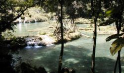
Its climate is hot and humid in the Pacific and Petén
Petén
Petén or Peten may refer to:*Petén , a department of Guatemala*Petén Basin, the geographical / archaeological region of Mesoamerica and a center of the Maya civilization*Lake Petén Itzá, a lake in the Petén Basin region...
Lowlands – more temperate in the highlands, to freezing cold at the high of the Cuchumatanes range, and hot/drier in the easternmost departments.
Polochic River
The Polochic River is a 194 km long river in eastern Guatemala. It flows eastwards through a deep valley and flows into Lake Izabal at . The river is navigable for length of 30 km to Panzós. It was used many years ago to transport coffee and timber, but most commercial transport in the river valley...
which drains in Lake Izabal
Lake Izabal
Lago de Izabal, also known as the Golfo Dulce, is the largest lake in Guatemala with a surface area of 589.6 km² and a maximum depth is 18 meters . The Polochic River is the largest river that drains into the lake...
, Río Dulce, Motagua and Sarstún
Sarstoon River
Sarstoon River is a river in the Toledo District of Belize. It forms the country's southern boundary with Guatemala.The river's sources are located in neighbouring Guatemala, where it is known by its Spanish name, Río Sarstún. It flows through the Guatemalan departments of Alta Verapaz and Izabal...
that forms the boundary with Belize
Belize
Belize is a constitutional monarchy and the northernmost country in Central America. Belize has a diverse society, comprising many cultures and languages. Even though Kriol and Spanish are spoken among the population, Belize is the only country in Central America where English is the official...
in the Caribbean
Caribbean
The Caribbean is a crescent-shaped group of islands more than 2,000 miles long separating the Gulf of Mexico and the Caribbean Sea, to the west and south, from the Atlantic Ocean, to the east and north...
and the Gulf of Mexico
Gulf of Mexico
The Gulf of Mexico is a partially landlocked ocean basin largely surrounded by the North American continent and the island of Cuba. It is bounded on the northeast, north and northwest by the Gulf Coast of the United States, on the southwest and south by Mexico, and on the southeast by Cuba. In...
vertient (Usumacinta, which forms the boundary between Chiapas
Chiapas
Chiapas officially Estado Libre y Soberano de Chiapas is one of the 31 states that, with the Federal District, comprise the 32 Federal Entities of Mexico. It is divided in 118 municipalities and its capital city is Tuxtla Gutierrez. Other important cites in Chiapas include San Cristóbal de las...
, Mexico
Mexico
The United Mexican States , commonly known as Mexico , is a federal constitutional republic in North America. It is bordered on the north by the United States; on the south and west by the Pacific Ocean; on the southeast by Guatemala, Belize, and the Caribbean Sea; and on the east by the Gulf of...
and Petén and its tributaries such as La Pasión
Pasión River
The Pasión River is a river located in the northern lowlands region of Guatemala. The river is fed by a number of upstream tributaries whose sources lie in the hills of Alta Verapaz. These flow in a general northerly direction to form the Pasión, which then tends westwards to meet up with the...
and San Pedro
San Pedro River (Guatemala)
The Río San Pedro is a river of Guatemala and Mexico. Its sources are located in the Guatemalan department of El Petén. at . The river flows westwards until it reaches the Mexican border and crosses into the state of Tabasco at . From there it continues northwest and joins the Usumacinta River...
.
All major cities are in the Highlands and the Pacific Lowlands. Major cities are the capital Guatemala City
Guatemala City
Guatemala City , is the capital and largest city of the Republic of Guatemala and Central America...
, elevation 1,600 m (Central Highlands
Guatemalan Highlands
The Guatemalan Highlands is an upland region in southern Guatemala, lying between the Sierra Madre de Chiapas to the south and the Petén lowlands to the north....
), Antigua Guatemala
Antigua Guatemala
Antigua Guatemala is a city in the central highlands of Guatemala famous for its well-preserved Spanish Mudéjar-influenced Baroque architecture as well as a number of spectacular ruins of colonial churches...
, elevation 1,533 m (Central Highlands
Guatemalan Highlands
The Guatemalan Highlands is an upland region in southern Guatemala, lying between the Sierra Madre de Chiapas to the south and the Petén lowlands to the north....
), Quetzaltenango
Quetzaltenango
Quetzaltenango, also commonly known by its indigenous name, Xelajú , or more commonly, Xela , is the second largest city of Guatemala. It is both the capital of Quetzaltenango Department and the municipal seat of Quetzaltenango municipality....
elevation 2,350 m (Western Highlands
Guatemalan Highlands
The Guatemalan Highlands is an upland region in southern Guatemala, lying between the Sierra Madre de Chiapas to the south and the Petén lowlands to the north....
), Escuintla
Escuintla
Escuintla is a city in south central Guatemala. It is the capital of the Escuintla Department and the administrative seat of Escuintla Municipality....
elevation 300 m, Mazatenango elevation 220 m and Coatepeque
Coatepeque
Coatepeque may refer to either of the following geographical locations:*El Salvador**Coatepeque, Santa Ana**Coatepeque Caldera*Guatemala**Coatepeque, Quetzaltenango...
elevation 515 m, (Pacific Lowlands). The largest lake Lago de Izabal (589.6 km²), is close to the Caribbean coast. Volcán Tajumulco
Volcán Tajumulco
Volcán Tajumulco is a large stratovolcano in the department of San Marcos in western Guatemala. It is the highest mountain in Guatemala and Central America at...
, 4,220 m, the highest point in Central America, is located in the western department of San Marcos.
Guatemala's location on the Caribbean Sea and Pacific Ocean makes it a target for hurricanes, including Hurricane Mitch
Hurricane Mitch
Hurricane Mitch was the most powerful hurricane and the most destructive of the 1998 Atlantic hurricane season, with maximum sustained winds of 180 mph . The storm was the thirteenth tropical storm, ninth hurricane, and third major hurricane of the season. Along with Hurricane Georges, Mitch...
in 1998 and Hurricane Stan
Hurricane Stan
Hurricane Stan was the eighteenth named tropical storm and eleventh hurricane of the 2005 Atlantic hurricane season. It was also the sixth of seven tropical cyclones to make landfall in Mexico. Stan was a relatively weak storm that only briefly reached hurricane status...
in October 2005, which killed more than 1,500 people. (The damage was not wind related, but caused by flooding and landslides).
The last major earthquake
1976 Guatemala earthquake
The 1976 Guatemala earthquake struck on February 4, 1976 at 03:01:43 local time . It was a 7.5 Mw earthquake, centered in the Motagua Fault, about 160 km northeast of Guatemala City, Guatemala...
was on February 4, 1976, killing more than 23,000 in the Central Highlands (see also: Earthquakes in Guatemala
Earthquakes in Guatemala
Earthquakes are relatively frequent occurrences in Guatemala. The country lies in a major fault zone, known as the Motagua and Chixoy-Polochic fault complex, which cuts across Guatemala and forms the tectonic boundary between the Caribbean plate and the North American plate...
).
Geographic data
- Central AmericaCentral AmericaCentral America is the central geographic region of the Americas. It is the southernmost, isthmian portion of the North American continent, which connects with South America on the southeast. When considered part of the unified continental model, it is considered a subcontinent...
, bordering the Caribbean SeaCaribbean SeaThe Caribbean Sea is a sea of the Atlantic Ocean located in the tropics of the Western hemisphere. It is bounded by Mexico and Central America to the west and southwest, to the north by the Greater Antilles, and to the east by the Lesser Antilles....
, between HondurasHondurasHonduras is a republic in Central America. It was previously known as Spanish Honduras to differentiate it from British Honduras, which became the modern-day state of Belize...
and BelizeBelizeBelize is a constitutional monarchy and the northernmost country in Central America. Belize has a diverse society, comprising many cultures and languages. Even though Kriol and Spanish are spoken among the population, Belize is the only country in Central America where English is the official...
and bordering the North Pacific Ocean, between El SalvadorEl SalvadorEl Salvador or simply Salvador is the smallest and the most densely populated country in Central America. The country's capital city and largest city is San Salvador; Santa Ana and San Miguel are also important cultural and commercial centers in the country and in all of Central America...
and MexicoMexicoThe United Mexican States , commonly known as Mexico , is a federal constitutional republic in North America. It is bordered on the north by the United States; on the south and west by the Pacific Ocean; on the southeast by Guatemala, Belize, and the Caribbean Sea; and on the east by the Gulf of...
Geographic coordinates:
- 15°30′N 90°15′W
Map references:
- Central America and the CaribbeanCaribbeanThe Caribbean is a crescent-shaped group of islands more than 2,000 miles long separating the Gulf of Mexico and the Caribbean Sea, to the west and south, from the Atlantic Ocean, to the east and north...
Area:
- Total: 108,890 km²
- Land: 107,940 km²
Land boundaries:
- Total: 1,687 km
- Border countries: Belize 266 km, El Salvador 203 km, Honduras 256 km, Mexico 962 km
Coastline:
- 400 km
Maritime claims:
- Continental shelf: 200 m depth or to the depth of exploitation
- Exclusive economic zone: 200 nmi (370.4 km)
- Territorial sea: 12 nmi (22.2 km)
Terrain:
- Mostly mountains with narrow coastal plains and rolling limestone plateau (Peten)
Elevation extremes:
- Lowest point: Pacific OceanPacific OceanThe Pacific Ocean is the largest of the Earth's oceanic divisions. It extends from the Arctic in the north to the Southern Ocean in the south, bounded by Asia and Australia in the west, and the Americas in the east.At 165.2 million square kilometres in area, this largest division of the World...
0 m - Highest point: Volcán TajumulcoVolcán TajumulcoVolcán Tajumulco is a large stratovolcano in the department of San Marcos in western Guatemala. It is the highest mountain in Guatemala and Central America at...
4,220 m
Natural resources:
- PetroleumPetroleumPetroleum or crude oil is a naturally occurring, flammable liquid consisting of a complex mixture of hydrocarbons of various molecular weights and other liquid organic compounds, that are found in geologic formations beneath the Earth's surface. Petroleum is recovered mostly through oil drilling...
, nickelNickelNickel is a chemical element with the chemical symbol Ni and atomic number 28. It is a silvery-white lustrous metal with a slight golden tinge. Nickel belongs to the transition metals and is hard and ductile...
, rare woods, fishFishFish are a paraphyletic group of organisms that consist of all gill-bearing aquatic vertebrate animals that lack limbs with digits. Included in this definition are the living hagfish, lampreys, and cartilaginous and bony fish, as well as various extinct related groups...
, chicleChicleManilkara chicle is a tropical evergreen tree native to Mexico and Central America. The tree ranges from Veracruz in Mexico south to Atlántico in Colombia...
, hydropowerHydropowerHydropower, hydraulic power, hydrokinetic power or water power is power that is derived from the force or energy of falling water, which may be harnessed for useful purposes. Since ancient times, hydropower has been used for irrigation and the operation of various mechanical devices, such as...
Land use:
- Arable land: 12%
- Permanent crops: 5%
- Permanent pastures: 24%
- Forests and woodland: 54%
- Other: 5% (1993 est.)
Irrigated land:
- 1,250 km² (1993 est.)
Natural hazards:
- Several active volcanoes, occasional violent earthquakesEarthquakes in GuatemalaEarthquakes are relatively frequent occurrences in Guatemala. The country lies in a major fault zone, known as the Motagua and Chixoy-Polochic fault complex, which cuts across Guatemala and forms the tectonic boundary between the Caribbean plate and the North American plate...
; Caribbean coast subject to hurricanes and other tropical storms, causing flooding, mudflows and landslides
Environment—current issues:
- Deforestation; soil erosion; water pollution
Environment—international agreements:
- Party to: Antarctic Treaty, BiodiversityBiodiversityBiodiversity is the degree of variation of life forms within a given ecosystem, biome, or an entire planet. Biodiversity is a measure of the health of ecosystems. Biodiversity is in part a function of climate. In terrestrial habitats, tropical regions are typically rich whereas polar regions...
, Climate ChangeUnited Nations Framework Convention on Climate ChangeThe United Nations Framework Convention on Climate Change is an international environmental treaty produced at the United Nations Conference on Environment and Development , informally known as the Earth Summit, held in Rio de Janeiro from June 3 to 14, 1992...
, Climate Change-Kyoto Protocol, DesertificationDesertificationDesertification is the degradation of land in drylands. Caused by a variety of factors, such as climate change and human activities, desertification is one of the most significant global environmental problems.-Definitions:...
, Endangered SpeciesEndangered speciesAn endangered species is a population of organisms which is at risk of becoming extinct because it is either few in numbers, or threatened by changing environmental or predation parameters...
, Environmental Modification, Hazardous Wastes, Law of the SeaLaw of the seaLaw of the sea may refer to:* United Nations Convention on the Law of the Sea* Admiralty law* The Custom of the Sea...
, Marine Dumping, Nuclear Test Ban, Ozone Layer Protection, Ship Pollution (MARPOL 73/78MARPOL 73/78Marpol 73/78 is the International Convention for the Prevention of Pollution From Ships, 1973 as modified by the Protocol of 1978....
), Wetlands - Signed, but not ratified: Antarctic-Environmental Protocol
Geography—note:
- No natural harbors on west coast
See also
- List of places in Guatemala
- Guatemala BiodiversityGuatemala BiodiversityAccording to Parkswatch and the IUCN, Guatemala is considered the fifth biodiversity hotspot in the world. The country has 14 ecoregions ranging from mangrove forest , in both ocean littorals, dry forests and scrublands in the eastern highlands, subtropical and tropical rain forests, wetlands,...
- Earthquakes in GuatemalaEarthquakes in GuatemalaEarthquakes are relatively frequent occurrences in Guatemala. The country lies in a major fault zone, known as the Motagua and Chixoy-Polochic fault complex, which cuts across Guatemala and forms the tectonic boundary between the Caribbean plate and the North American plate...