
Geography of Ghana
Encyclopedia
 |
|
| Continent Continent A continent is one of several very large landmasses on Earth. They are generally identified by convention rather than any strict criteria, with seven regions commonly regarded as continents—they are : Asia, Africa, North America, South America, Antarctica, Europe, and Australia.Plate tectonics is... |
Africa Africa Africa is the world's second largest and second most populous continent, after Asia. At about 30.2 million km² including adjacent islands, it covers 6% of the Earth's total surface area and 20.4% of the total land area... |
| Geographic coordinates | 8°00′N 2°00′W |
| Area Area Area is a quantity that expresses the extent of a two-dimensional surface or shape in the plane. Area can be understood as the amount of material with a given thickness that would be necessary to fashion a model of the shape, or the amount of paint necessary to cover the surface with a single coat... - Total - % water |
Ranked 81st 238,540 km² 3.5% (8,520 km²) |
| Coastline | 700 km |
| Highest point | Mount Afadjato Mount Afadjato Mount Afadjato is the highest mountain in Ghana, at an altitude of . The mountain is located in the Agumatsa Range near the villages of Liati Wote and Gbledi, in the Volta Region of Ghana at the border with Togo... , 880 m |
| Lowest point | Atlantic Ocean Atlantic Ocean The Atlantic Ocean is the second-largest of the world's oceanic divisions. With a total area of about , it covers approximately 20% of the Earth's surface and about 26% of its water surface area... , 0 m |
| Longest river | Volta Volta River The Volta is a river in western Africa that drains into the Gulf of Guinea. It has three main tributaries—the Black Volta, White Volta and Red Volta... |
| Largest inland body of water | Lake Volta Lake Volta Lake Volta is the largest reservoir by surface area in the world, and the fourth largest one by water volume. It is located completely within the country of Ghana, and it has a surface area of about 8,502 km² . Lake Volta lies along the Greenwich Meridian, and just six degrees of latitude... |
| Land Use - Arable land - Permanent crops - Permanent pastures - Forests and woodlands - Other |
12 % 7 % 22 % 35 % 24 % (1993 est.) |
| Climate Climate Climate encompasses the statistics of temperature, humidity, atmospheric pressure, wind, rainfall, atmospheric particle count and other meteorological elemental measurements in a given region over long periods... |
Tropical Tropics The tropics is a region of the Earth surrounding the Equator. It is limited in latitude by the Tropic of Cancer in the northern hemisphere at approximately N and the Tropic of Capricorn in the southern hemisphere at S; these latitudes correspond to the axial tilt of the Earth... |
| HDI Index | ---- |
| Natural resources | gold Gold Gold is a chemical element with the symbol Au and an atomic number of 79. Gold is a dense, soft, shiny, malleable and ductile metal. Pure gold has a bright yellow color and luster traditionally considered attractive, which it maintains without oxidizing in air or water. Chemically, gold is a... , timber Timber Timber may refer to:* Timber, a term common in the United Kingdom and Australia for wood materials * Timber, Oregon, an unincorporated community in the U.S... , industrial diamond Diamond In mineralogy, diamond is an allotrope of carbon, where the carbon atoms are arranged in a variation of the face-centered cubic crystal structure called a diamond lattice. Diamond is less stable than graphite, but the conversion rate from diamond to graphite is negligible at ambient conditions... s, bauxite Bauxite Bauxite is an aluminium ore and is the main source of aluminium. This form of rock consists mostly of the minerals gibbsite Al3, boehmite γ-AlO, and diaspore α-AlO, in a mixture with the two iron oxides goethite and hematite, the clay mineral kaolinite, and small amounts of anatase TiO2... , manganese Manganese Manganese is a chemical element, designated by the symbol Mn. It has the atomic number 25. It is found as a free element in nature , and in many minerals... , fish Fish Fish are a paraphyletic group of organisms that consist of all gill-bearing aquatic vertebrate animals that lack limbs with digits. Included in this definition are the living hagfish, lampreys, and cartilaginous and bony fish, as well as various extinct related groups... , rubber Rubber Natural rubber, also called India rubber or caoutchouc, is an elastomer that was originally derived from latex, a milky colloid produced by some plants. The plants would be ‘tapped’, that is, an incision made into the bark of the tree and the sticky, milk colored latex sap collected and refined... , hydropower Hydropower Hydropower, hydraulic power, hydrokinetic power or water power is power that is derived from the force or energy of falling water, which may be harnessed for useful purposes. Since ancient times, hydropower has been used for irrigation and the operation of various mechanical devices, such as... , oil Oil An oil is any substance that is liquid at ambient temperatures and does not mix with water but may mix with other oils and organic solvents. This general definition includes vegetable oils, volatile essential oils, petrochemical oils, and synthetic oils.... |
| Environmental issues | drought Drought A drought is an extended period of months or years when a region notes a deficiency in its water supply. Generally, this occurs when a region receives consistently below average precipitation. It can have a substantial impact on the ecosystem and agriculture of the affected region... , deforestation Deforestation Deforestation is the removal of a forest or stand of trees where the land is thereafter converted to a nonforest use. Examples of deforestation include conversion of forestland to farms, ranches, or urban use.... , overgrazing Overgrazing Overgrazing occurs when plants are exposed to intensive grazing for extended periods of time, or without sufficient recovery periods. It can be caused by either livestock in poorly managed agricultural applications, or by overpopulations of native or non-native wild animals.Overgrazing reduces the... , soil erosion, poaching Poaching Poaching is the illegal taking of wild plants or animals contrary to local and international conservation and wildlife management laws. Violations of hunting laws and regulations are normally punishable by law and, collectively, such violations are known as poaching.It may be illegal and in... , habitat destruction Habitat destruction Habitat destruction is the process in which natural habitat is rendered functionally unable to support the species present. In this process, the organisms that previously used the site are displaced or destroyed, reducing biodiversity. Habitat destruction by human activity mainly for the purpose of... , water pollution Water pollution Water pollution is the contamination of water bodies . Water pollution occurs when pollutants are discharged directly or indirectly into water bodies without adequate treatment to remove harmful compounds.... , drinking water Drinking water Drinking water or potable water is water pure enough to be consumed or used with low risk of immediate or long term harm. In most developed countries, the water supplied to households, commerce and industry is all of drinking water standard, even though only a very small proportion is actually... |
Ghana
Ghana
Ghana , officially the Republic of Ghana, is a country located in West Africa. It is bordered by Côte d'Ivoire to the west, Burkina Faso to the north, Togo to the east, and the Gulf of Guinea to the south...
is a country in West Africa
West Africa
West Africa or Western Africa is the westernmost region of the African continent. Geopolitically, the UN definition of Western Africa includes the following 16 countries and an area of approximately 5 million square km:-Flags of West Africa:...
, along the Gulf of Guinea
Gulf of Guinea
The Gulf of Guinea is the northeasternmost part of the tropical Atlantic Ocean between Cape Lopez in Gabon, north and west to Cape Palmas in Liberia. The intersection of the Equator and Prime Meridian is in the gulf....
, just a few degrees north of the equator
Equator
An equator is the intersection of a sphere's surface with the plane perpendicular to the sphere's axis of rotation and containing the sphere's center of mass....
.
Location and size
Ghana, which lies in the center of the West African coast, shares 2,093 km of land borders with the three French-speaking nations of Burkina FasoBurkina Faso
Burkina Faso – also known by its short-form name Burkina – is a landlocked country in west Africa. It is surrounded by six countries: Mali to the north, Niger to the east, Benin to the southeast, Togo and Ghana to the south, and Côte d'Ivoire to the southwest.Its size is with an estimated...
(548 km) to the north, Côte d'Ivoire
Côte d'Ivoire
The Republic of Côte d'Ivoire or Ivory Coast is a country in West Africa. It has an area of , and borders the countries Liberia, Guinea, Mali, Burkina Faso and Ghana; its southern boundary is along the Gulf of Guinea. The country's population was 15,366,672 in 1998 and was estimated to be...
(668 km) to the west, and Togo
Togo
Togo, officially the Togolese Republic , is a country in West Africa bordered by Ghana to the west, Benin to the east and Burkina Faso to the north. It extends south to the Gulf of Guinea, on which the capital Lomé is located. Togo covers an area of approximately with a population of approximately...
(877 km) to the east. To the south are the Gulf of Guinea and the Atlantic Ocean.
With a total area of 238,533 square kilometers, Ghana is about the size of the United Kingdom
United Kingdom
The United Kingdom of Great Britain and Northern IrelandIn the United Kingdom and Dependencies, other languages have been officially recognised as legitimate autochthonous languages under the European Charter for Regional or Minority Languages...
, or slightly smaller than Oregon
Oregon
Oregon is a state in the Pacific Northwest region of the United States. It is located on the Pacific coast, with Washington to the north, California to the south, Nevada on the southeast and Idaho to the east. The Columbia and Snake rivers delineate much of Oregon's northern and eastern...
. Its southernmost coast at Cape Three Points
Cape Three Points
Cape Three Points is a small peninsula in the Western Region of Ghana, West Africa.Forming the southernmost tip of Ghana, it is located between the coastal towns of Dixcove and Princes Town, Ghana...
is 4° 30' north of the equator. From here, the country extends inland for some 670 kilometers to about 11° north
11th parallel north
The 11th parallel north is a circle of latitude that is 11 degrees north of the Earth's equatorial plane. It crosses Africa, the Indian Ocean, South Asia, Southeast Asia, the Pacific Ocean, Central America, South America and the Atlantic Ocean....
. The distance across the widest part, between longitude 1° 12' east and longitude 3° 15' west, measures about 560 kilometers. The Greenwich Meridian, which passes through London, also traverses the eastern part of Ghana at Tema
Tema
Tema is a city on the Atlantic coast of Ghana, lying east of the Ghanaian capital city, Accra, in the region of Greater Accra. As of 2005, Tema had a population of 209,000. The Greenwich Meridian passes directly through the city...
.
Maritime claims:
contiguous zone:
24 nmi (44.4 km; 27.6 mi)
continental shelf:
200 nmi (370.4 km; 230.2 mi)
exclusive economic zone:
200 nmi (370.4 km; 230.2 mi)
territorial sea:
12 nmi (22.2 km; 13.8 mi)
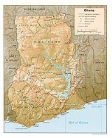
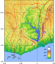
Terrain of Ghana
The terrain consists mostly low plains with the Kwahu PlateauKwahu Plateau
The Kwahu Plateau is a long plateau in Ghana. It forms the country's watershed, separating the two main river networks in the country....
in the south-central area. Half of the country lies less than 152 metres (499 ft) above sea level, and the highest point is 883 metres (2,897 ft). The 537 kilometres (334 mi) coastline is mostly a low, sandy shore backed by plains and scrub and intersected by several rivers and streams, most of which are navigable only by canoe
Canoe
A canoe or Canadian canoe is a small narrow boat, typically human-powered, though it may also be powered by sails or small electric or gas motors. Canoes are usually pointed at both bow and stern and are normally open on top, but can be decked over A canoe (North American English) or Canadian...
. A tropical rain forest belt, broken by heavily forested hills and many streams and rivers, extends northward from the shore, near the Côte d'Ivoire
Côte d'Ivoire
The Republic of Côte d'Ivoire or Ivory Coast is a country in West Africa. It has an area of , and borders the countries Liberia, Guinea, Mali, Burkina Faso and Ghana; its southern boundary is along the Gulf of Guinea. The country's population was 15,366,672 in 1998 and was estimated to be...
frontier. This area, known as the "Ashanti," produces most of the country's cocoa, minerals, and timber
Timber
Timber may refer to:* Timber, a term common in the United Kingdom and Australia for wood materials * Timber, Oregon, an unincorporated community in the U.S...
. North of this belt, the country varies from 91 to 396 m (298.6 to 1,299.2 ft) above sea level and is covered by low bush, park-like savanna
Savanna
A savanna, or savannah, is a grassland ecosystem characterized by the trees being sufficiently small or widely spaced so that the canopy does not close. The open canopy allows sufficient light to reach the ground to support an unbroken herbaceous layer consisting primarily of C4 grasses.Some...
, and grassy plains.
Irrigated land:
60 km² (1993 est)
Geographical regions
Terrain
Terrain, or land relief, is the vertical and horizontal dimension of land surface. When relief is described underwater, the term bathymetry is used...
. Indeed, the Precambrian
Precambrian
The Precambrian is the name which describes the large span of time in Earth's history before the current Phanerozoic Eon, and is a Supereon divided into several eons of the geologic time scale...
rock system that underlies most of the nation has been worn down by erosion almost to a plain. The highest elevation in Ghana, Mount Afadjato
Mount Afadjato
Mount Afadjato is the highest mountain in Ghana, at an altitude of . The mountain is located in the Agumatsa Range near the villages of Liati Wote and Gbledi, in the Volta Region of Ghana at the border with Togo...
in the Akwapim-Togo Ranges, rises only 880 meters above sea level.Due to many of the years that have passed that make it 889 meters above sea level
There are, nonetheless, four distinct geographical regions. Low plains stretch across the southern part of the country. To their north lie three regions--the Ashanti Uplands, the Akwapim-Togo Ranges, and the Volta Basin. The fourth region, the high plains, occupies the northern and northwestern sector of the country. Like most West African countries, Ghana has no natural harbors. Because strong surf pounds the shoreline, two artificial harbors were built at Takoradi and Tema
Tema
Tema is a city on the Atlantic coast of Ghana, lying east of the Ghanaian capital city, Accra, in the region of Greater Accra. As of 2005, Tema had a population of 209,000. The Greenwich Meridian passes directly through the city...
(the latter completed in 1961) to accommodate Ghana's shipping needs.
Low Plains
The low plains comprise the four subregions of the coastal savanna, the Volta Delta, the Accra Plains, and the Akan lowlands or peneplains. A narrow strip of grassy and scrubby coast runs from a point near Takoradi in the west to the TogoTogo
Togo, officially the Togolese Republic , is a country in West Africa bordered by Ghana to the west, Benin to the east and Burkina Faso to the north. It extends south to the Gulf of Guinea, on which the capital Lomé is located. Togo covers an area of approximately with a population of approximately...
border in the east. This coastal savanna, only about eight kilometers in width at its western end, stretches eastward through the Accra Plains, where it widens to more than eighty kilometers, and terminates at the southeastern corner of the country at the lower end of the Akwapim-Togo Ranges.
Almost flat and featureless, the Accra Plains descend gradually to the gulf from a height of about 150 meters. The topography east of the city of Accra is marked by a succession of ridges and spoonshaped valleys. The hills and slopes in this area are the favored lands for cultivation. Shifting cultivation
Shifting cultivation
Shifting cultivation is an agricultural system in which plots of land are cultivated temporarily, then abandoned. This system often involves clearing of a piece of land followed by several years of wood harvesting or farming, until the soil loses fertility...
is the usual agricultural practice because of the swampy nature of the very lowlying areas during the rainy seasons and the periodic blocking of the rivers at the coast by sandbars that form lagoons. A plan to irrigate the Accra Plains was announced in 1984. Should this plan come to reality, much of the area could be opened to large-scale cultivation.
To the west of Accra, the low plains contain wider valleys and rounded low hills, with occasional rocky headlands. In general, however, the land is flat and covered with grass and scrub. Dense groves of coconut palms front the coastline. Several commercial centers, including Winneba, Saltpond, and Cape Coast, are located here. Although Winneba has a small livestock industry and palm tree cultivation is expanding in the area away from the coast, the predominant occupation of the coastal inhabitants is fishing by dug-out canoe.
The Volta Delta, which forms a distinct subregion of the low plains, extends into the Gulf of Guinea
Gulf of Guinea
The Gulf of Guinea is the northeasternmost part of the tropical Atlantic Ocean between Cape Lopez in Gabon, north and west to Cape Palmas in Liberia. The intersection of the Equator and Prime Meridian is in the gulf....
in the extreme southeast. The delta's rock formation--consisting of thick layers of sandstone
Sandstone
Sandstone is a sedimentary rock composed mainly of sand-sized minerals or rock grains.Most sandstone is composed of quartz and/or feldspar because these are the most common minerals in the Earth's crust. Like sand, sandstone may be any colour, but the most common colours are tan, brown, yellow,...
, some limestone
Limestone
Limestone is a sedimentary rock composed largely of the minerals calcite and aragonite, which are different crystal forms of calcium carbonate . Many limestones are composed from skeletal fragments of marine organisms such as coral or foraminifera....
, and silt
Silt
Silt is granular material of a size somewhere between sand and clay whose mineral origin is quartz and feldspar. Silt may occur as a soil or as suspended sediment in a surface water body...
deposits--is flat, featureless, and relatively young. As the delta grew outward over the centuries, sandbars developed across the mouths of the Volta and smaller rivers that empty into the gulf in the same area, forming numerous lagoons, some quite large, making road construction difficult. To avoid the lowest-lying areas, for example, the road between Accra and Keta makes an unusual detour inland just before reaching Ada and finally approaches Keta from the east along the narrow spit on which the town stands. This notwithstanding, road links with Keta continue to be a problem. By 1989 it was estimated that more than 3,000 houses in the town had been swallowed by flooding from the lagoon. In addition, about 1,500 other houses were destroyed by erosion caused by the powerful waves of the sea.
Ironically, it is this flat, silt-composed delta region with its abundance of water that supports shallot
Shallot
The shallot is the botanical variety of Allium cepa to which the multiplier onion also belongs. It was formerly classified as the species A. ascalonicum, a name now considered a synonym of the correct name...
, corn
Maize
Maize known in many English-speaking countries as corn or mielie/mealie, is a grain domesticated by indigenous peoples in Mesoamerica in prehistoric times. The leafy stalk produces ears which contain seeds called kernels. Though technically a grain, maize kernels are used in cooking as a vegetable...
, and cassava
Cassava
Cassava , also called yuca or manioc, a woody shrub of the Euphorbiaceae native to South America, is extensively cultivated as an annual crop in tropical and subtropical regions for its edible starchy tuberous root, a major source of carbohydrates...
cultivation in the region. Moreover, the sandy soil of the delta gave rise to the copra
Copra
Copra is the dried meat, or kernel, of the coconut. Coconut oil extracted from it has made copra an important agricultural commodity for many coconut-producing countries. It also yields coconut cake which is mainly used as feed for livestock.-Production:...
industry. Salt
Salt
In chemistry, salts are ionic compounds that result from the neutralization reaction of an acid and a base. They are composed of cations and anions so that the product is electrically neutral...
-making, from the plentiful supply in the dried beds of the lagoons, provides additional employment. The main occupation of the delta people, however, continues to be fishing, an industry that supplies dried and salted fish to other parts of the country.
The largest part of the low plains is the Akan Lowlands. Some experts prefer to classify this region as a subdivision of the Ashanti Uplands because of the many characteristics they share. Unlike the uplands, however, the height of the Akan Lowlands is generally between sea level and 150 meters. Some ranges and hills rise to about 300 meters, but few exceed 600 meters. The lowlands that lie to the south of the Ashanti Uplands receive the many rivers that make their way to the sea.
The Akan Lowlands contain the basins of the Densu River
Densu River
The Densu River is a 116km long river in Ghana rising in the Atewa Range. It flows through an economically important agricultural region, supplies half the drinking water to Ghana's capital city of Accra, and ends in an ecologically significant but environmentally threatened wetlands at the edge...
, the Pra River
Pra River (Ghana)
The Pra River is a river in Ghana, the easternmost and the largest of the three principal rivers that drain the area south of the Volta divide. Rising in the Kwahu Plateau near Mpraeso and flowing southward for 240 km through rich cocoa and farming areas and valuable forests in the Akan...
, the Ankobra River
Ankobra River
The Ankobra River is situated in Western Africa. Rising north east of Wiawso, it flows about 120 miles south to the Gulf of Guinea. Its entire course is in southern Ghana...
, and the Tano River
Tano River
The Tano or Tanoé River is a river in Ghana. It flows for 400 kilometres from Techiman to Ehy, Tendo and finally Aby Lagoon where it enters the Atlantic Ocean...
, all of which play important roles in the economy of Ghana. The Densu River Basin, location of the important urban centers of Koforidua
Koforidua
Koforidua, also popularly known as Kof-town, is a city in the West African republic of Ghana, about an hour by road from Accra. It is the capital of the Eastern Region of Ghana and has a population of 87,315 ....
and Nsawam
Nsawam
Nsawam is a town in the Eastern Region of Ghana approximately 40 km northwest from the capital, Accra. It is controlled by the Akwapim Society....
in the eastern lowlands, has an undulating topography. Many of the hills here have craggy summits, which give a striking appearance to the landscape. The upper section of the Pra River Basin, to the west of the Densu, is relatively flat; the topography of its lower reaches, however, resembles that of the Densu Basin and is a rich cocoa and food-producing region. The valley of the Birim River, one of the main tributaries of the Pra, is the country's most important diamond-producing area.
The Ankobra River Basin and the middle and lower basins of the Tano River to the west of the lowlands form the largest subdivision of the Akan Lowlands. Here annual rainfall between 1,500 and 2,150 millimeters helps assure a dense forest cover. In addition to timber, the area is rich in minerals. The Tarkwa goldfield, the diamond operations of the Bonsa Valley, and high-grade manganese deposits are all found in this area. The middle and lower Tano basins have been intensely explored for oil and natural gas since the mid-1980s. The lower basins of the Pra, Birim, Densu, and Ankobra rivers are also sites for palm tree cultivation.
Ashanti Uplands
Comprising the Southern Ashanti Uplands and the Kwahu Plateau, the Ashanti Uplands lie just north of the Akan Lowlands and stretch from the Côte d'Ivoire border in the west to the elevated edge of the Volta Basin in the east. Stretching in a northwest-to-southeast direction, the Kwahu Plateau extends 193 kilometers between Koforidua in the east and Wenchi in the northwest. The average elevation of the plateau is about 450 meters, rising to a maximum of 762 meters. The relatively cool temperatures of the plateau were attractive to Europeans, particularly missionaries, who founded many well-known schools and colleges in this region.The plateau forms one of the important physical divides in Ghana. From its northeastern slopes, the Afram and Pru Rivers flow into the Volta River, while from the opposite side, the Pra, Birim, Ofin, Tano, and other rivers flow south toward the sea. The plateau also marks the northernmost limit of the forest zone. Although large areas of the forest cover have been destroyed through farming, enough deciduous forest remains to shade the head waters of the rivers that flow from the plateau.
The Southern Ashanti Uplands, extending from the foot of the Kwahu Plateau in the north to the lowlands in the south, slope gently from an elevation of about 300 meters in the north to about 150 meters in the south. The region, however, contains several hills and ranges as well as several towns of historical and economic importance, including Kumasi
Kumasi
Kumasi is a city in southern central Ghana's Ashanti region. It is located near Lake Bosomtwe, in the Rain Forest Region about northwest of Accra. Kumasi is approximately north of the Equator and north of the Gulf of Guinea...
, Ghana's second largest city and former capital of the Asante. Obuasi
Obuasi
Obuasi is a city in southern Ghana, lying south of Kumasi. It has a population of 115,564 On the railway line from Kumasi to Sekondi, it is known for its gold mine, now one of the ten largest in the world, gold having been mined on the site since at least the seventeenth century. Tourists can...
and Konongo
Konongo
The Konongo are an ethnic and linguistic group based in the Mpanda District of Rukwa Region in western Tanzania. In 1987 the Konongo population was estimated to number 51,000 ....
, two of the country's gold-mining centers, are also located here. The region is the country's chief producer of cocoa, and its tropical forests continue to be a vital source of timber for the lumber industry.
Volta Basin
Occupying the central part of Ghana, the Volta Basin covers about 45 percent of the nation's total land surface. Its northern section, which lies above the upper part of Lake VoltaLake Volta
Lake Volta is the largest reservoir by surface area in the world, and the fourth largest one by water volume. It is located completely within the country of Ghana, and it has a surface area of about 8,502 km² . Lake Volta lies along the Greenwich Meridian, and just six degrees of latitude...
, rises to a height of 150 to 215 meters above sea level. Elevations of the Konkori Scarp to the west and the Gambaga Scarp to the north reach from 300 to 460 meters. To the south and the southwest, the basin is less than 300 meters. The Kwahu Plateau marks the southern end of the basin, although it forms a natural part of the Ashanti Uplands.
The basin is characterized by poor soil, generally of Voltaian sandstone
Sandstone
Sandstone is a sedimentary rock composed mainly of sand-sized minerals or rock grains.Most sandstone is composed of quartz and/or feldspar because these are the most common minerals in the Earth's crust. Like sand, sandstone may be any colour, but the most common colours are tan, brown, yellow,...
. Annual rainfall averages between 1,000 and 1,140 millimeters. The most widespread vegetation type is savanna
Savanna
A savanna, or savannah, is a grassland ecosystem characterized by the trees being sufficiently small or widely spaced so that the canopy does not close. The open canopy allows sufficient light to reach the ground to support an unbroken herbaceous layer consisting primarily of C4 grasses.Some...
, the woodlands of which, depending on local soil and climatic conditions, may contain such trees as Red Ironwood and Shea.
The basin's population, principally farmers, is low in density, especially in the central and northwestern areas of the basin, where tsetse flies are common. Archeological finds indicate, however, that the region was once more heavily populated. Periodic burning evidently occurred over extensive areas for perhaps more than a millennium, exposing the soil to excessive drying and erosion, rendering the area less attractive to cultivators.
In contrast with the rest of the region are the Afram Plains, located in the southeastern corner of the basin. Here the terrain is low, averaging 60 to 150 meters in elevation, and annual rainfall is between 1,140 and about 1,400 millimeters. Near the Afram River, much of the surrounding countryside is flooded or swampy during the rainy seasons. With the creation of Lake Volta (8500 km² in area) in the mid-1960s, much of the Afram Plains was submerged. Despite the construction of roads to connect communities displaced by the lake, road transportation in the region remains poor. Renewed efforts to improve communications, to enhance agricultural production, and to improve standards of living began in earnest only in the mid-1980s.
High plains
The general terrain in the northern and northwestern part of Ghana outside the Volta Basin consists of a dissected plateau, which averages between 150 and 300 meters in elevation and, in some places, is even higher. Rainfall averages between 1,000 and 1,150 millimeters annually, although in the northwest it is closer to 1,350 millimeters. Soils in the high plains are more arable than those in the Volta Basin, and the population density is considerably higher. Grain and cattle production are the major economic activities in the high plains of the northern region. Since the mid-1980s, when former United States President Jimmy Carter's Global 2000 program (see Glossary) adopted Ghana as one of a select number of African countries whose local farmers were to be educated and financially supported to improve agricultural production, there has been a dramatic increase in grain production in northern Ghana. The virtual absence of tsetse flies in the region has led, moreover, to increased livestock raising as a major occupation in the north. In fact, the region is the country's largest producer of cattle.Rivers and lakes
Ghana is drained by a large number of streams and rivers. In addition, there are a number of coastal lagoons, the huge man-made Lake VoltaLake Volta
Lake Volta is the largest reservoir by surface area in the world, and the fourth largest one by water volume. It is located completely within the country of Ghana, and it has a surface area of about 8,502 km² . Lake Volta lies along the Greenwich Meridian, and just six degrees of latitude...
, and Lake Bosumtwi
Lake Bosumtwi
Lake Bosumtwi , situated within an ancient meteorite impact crater, is approximately 8 km across and the only natural lake in Ghana. It is situated about 30 km south-east of Kumasi and is a popular recreational area. There are about 30 villages near the lake, with a combined population of...
created by a meteorite
Meteorite
A meteorite is a natural object originating in outer space that survives impact with the Earth's surface. Meteorites can be big or small. Most meteorites derive from small astronomical objects called meteoroids, but they are also sometimes produced by impacts of asteroids...
, southeast of Kumasi
Kumasi
Kumasi is a city in southern central Ghana's Ashanti region. It is located near Lake Bosomtwe, in the Rain Forest Region about northwest of Accra. Kumasi is approximately north of the Equator and north of the Gulf of Guinea...
and which has no outlet to the sea. In the wetter south and southwest areas of Ghana, the river and stream pattern is denser, but in the area north of the Kwahu Plateau
Kwahu Plateau
The Kwahu Plateau is a long plateau in Ghana. It forms the country's watershed, separating the two main river networks in the country....
, the pattern is much more open, making access to water more difficult. Several streams and rivers also dry up or experience reduced flow during the dry seasons of the year, while flooding during the rainy seasons is common.
The major drainage divide runs from the southwest part of the Akwapim-Togo Ranges northwest through the Kwahu Plateau and then irregularly westward to the Côte d'Ivoire border. Almost all the rivers and streams north of this divide form part of the Volta system. Extending about 1,600 kilometers in length and draining an area of about 388,000 square kilometers, of which about 158,000 km² lie within Ghana, the Volta and its tributaries, such as the Afram River
Afram River
The Afram River is a 100 km river in Ghana. Prior to the construction of the Akosombo Dam in the 1960s, the Afram is a principal tributary of the Volta River and today is an equally important tributary of Lake Volta. The river runs roughly in a southwesterly direction. It collects all the...
and the Oti River, drain more than twothirds of the country. To the south of the divide are several smaller, independent rivers. The most important of these are the Pra River, the Tano River, the Ankobra River, the Birim River
Birim River
The Birim River is one of the main tributaries of the Pra River in Ghana and the country's most important diamond-producing area, flowing through most of the width of the Eastern region. The river rises in the east of the Atewa Range, flows north through the gap between this range and the Kwahu...
, and the Densu River
Densu River
The Densu River is a 116km long river in Ghana rising in the Atewa Range. It flows through an economically important agricultural region, supplies half the drinking water to Ghana's capital city of Accra, and ends in an ecologically significant but environmentally threatened wetlands at the edge...
. With the exception of smaller streams that dry up in the dry seasons or rivers that empty into inland lakes, all the major rivers in the country flow into the Gulf of Guinea directly or as tributaries to other major rivers. The Ankobra and Tano are navigable for considerable distances in their lower reaches.
Navigation on the Volta River has changed significantly since 1964. Construction of the dam at Akosombo, about 80 kilometers upstream from the coast, created the vast Lake Volta and the associated 1020 megawatt hydroelectric project. Arms of the lake extended into the lower-lying areas, forcing the relocation of 78,000 people to newly created townships on the lake's higher banks. The Black Volta River and the White Volta River flow separately into the lake. Before their confluence was submerged, the rivers came together in the middle of the country to form the main Volta River. The Oti River and the Daka River, the principal tributaries of the Volta in the eastern part of the country, and the Pru River, the Sene River, and the Afram River, major tributaries to the north of the Kawhu Plateau, also empty into flooded extensions of the lake in their river valleys. Lake Volta is a rich source of fish, and its potential as a source for irrigation is reflected in agricultural mechanization agreement signed in the late 1980s to irrigate the Afram Plains. The lake is navigable from Akosombo through Yeji in the middle of the country; a 24 meter pontoon
Pontoon (boat)
A pontoon is a flotation device with buoyancy sufficient to float itself as well as a heavy load. A pontoon boat is a flattish boat that relies on pontoons to float. Pontoons may be used on boats, rafts, barges, docks, floatplanes or seaplanes. Pontoons may support a platform, creating a raft. A...
was commissioned in 1989 to link the Afram Plains to the west of the lake with the lower Volta region to the east. Hydroelectricity generated from Akosombo supplies Ghana, Togo, and Benin.
On the other side of the Kwahu Plateau from Lake Volta are several river systems, including the Pra, Ankobra, Tano and Densu. The Pra is the easternmost and the largest of the three principal rivers that drain the area south of the Volta divide. Rising south of the Kwahu Plateau and flowing southward, the Pra enters the Gulf of Guinea east of Takoradi. In the early part of the twentieth century, the Pra was used extensively to float timber to the coast for export. This trade is now carried by road and rail transportation.
The Ankobra, which flows to the west of the Pra, has a relatively small drainage basin. It rises in the hilly region of Bibiani
Bibiani
Bibiani is the town capital of the Bibiani / Anhwiaso / Bekwai district in the Western Region of Ghana....
and flows in a southerly direction to enter the gulf just west of Axim
Axim
Axim is a town, district and kingdom on the coast of Ghana. It lies 64 kilometers west of the port city of Takoradi, south of the highway leading to the Côte d'Ivoire border, in the Western Region to the west of Cape Three Points....
. Small craft can navigate approximately eighty kilometers inland from its mouth. At one time, the Ankobra helped transport machinery to the gold-mining areas in the vicinity of Tarkwa. The Tano, which is the westernmost of the three rivers, rises near Techiman
Techiman
Techiman is the leading market town in Ghana and is, together with Sunyani, one of the two chief cities of the Brong-Ahafo Region. This city of nearly 80,000 is located at a historical crossroads of trade routes and the Tano River, and serves as capital of the Techiman Municipal...
in the center of the country. It also flows in a southerly direction, but it empties into a lagoon in the southeast corner of Côte d'Ivoire. Navigation by steam launch is possible on the southern sector of the Tano for about 70 kilometers.
A number of rivers are found to the east of the Pra. The two most important are the Densu and Ayensu, both of which rise in the Atewa Range
Atewa Range
The Atewa Range is in the Akyem Abuakwa region of southeastern Ghana, near the town of Kibi, and south-west of the Kwahu Plateau which forms the south-west boundary of Lake Volta. The range runs roughly north-south, consisting of steep-sided hills with fairly flat summits...
, and which are important as sources of water for Accra
Accra
Accra is the capital and largest city of Ghana, with an urban population of 1,658,937 according to the 2000 census. Accra is also the capital of the Greater Accra Region and of the Accra Metropolitan District, with which it is coterminous...
and Winneba
Winneba
Winneba, traditionally known as Simpa, also known as the Land of the Gharteys because its royals and many of its inhabitants bear this name,...
respectively. The country has one large natural lake, Lake Bosumtwi, located about 32 kilometers southeast of Kumasi. It occupies the steep-sided meteoric crater and has an area of about 47 square kilometers. A number of small streams flow into Lake Bosumtwi, but there is no drainage from it. Apart from providing an opportunity for fishing for local inhabitants, the lake serves as a tourist attraction!
Natural hazards
Dry, dusty, harmattanHarmattan
The Harmattan is a dry and dusty West African trade wind. It blows south from the Sahara into the Gulf of Guinea between the end of November and the middle of March...
winds occur from January to March. The country is also prone to droughts, and was severely affected by floods in 2007 and 2009.
Environment
Droughts in the north have had a severe effect on agricultureAgriculture
Agriculture is the cultivation of animals, plants, fungi and other life forms for food, fiber, and other products used to sustain life. Agriculture was the key implement in the rise of sedentary human civilization, whereby farming of domesticated species created food surpluses that nurtured the...
. Wildlife is threatened by poaching
Poaching
Poaching is the illegal taking of wild plants or animals contrary to local and international conservation and wildlife management laws. Violations of hunting laws and regulations are normally punishable by law and, collectively, such violations are known as poaching.It may be illegal and in...
and habitat destruction
Habitat destruction
Habitat destruction is the process in which natural habitat is rendered functionally unable to support the species present. In this process, the organisms that previously used the site are displaced or destroyed, reducing biodiversity. Habitat destruction by human activity mainly for the purpose of...
threatens wildlife populations.
International agreements (ratified):
Biodiversity
Biodiversity
Biodiversity is the degree of variation of life forms within a given ecosystem, biome, or an entire planet. Biodiversity is a measure of the health of ecosystems. Biodiversity is in part a function of climate. In terrestrial habitats, tropical regions are typically rich whereas polar regions...
, Climate Change
United Nations Framework Convention on Climate Change
The United Nations Framework Convention on Climate Change is an international environmental treaty produced at the United Nations Conference on Environment and Development , informally known as the Earth Summit, held in Rio de Janeiro from June 3 to 14, 1992...
, Desertification
Desertification
Desertification is the degradation of land in drylands. Caused by a variety of factors, such as climate change and human activities, desertification is one of the most significant global environmental problems.-Definitions:...
, Endangered Species
Endangered species
An endangered species is a population of organisms which is at risk of becoming extinct because it is either few in numbers, or threatened by changing environmental or predation parameters...
, Environmental Modification, Law of the Sea
Law of the sea
Law of the sea may refer to:* United Nations Convention on the Law of the Sea* Admiralty law* The Custom of the Sea...
, Nuclear Test Ban, Ozone Layer Protection, Ship Pollution, Tropical Timber 83, Tropical Timber 94, Wetlands
International agreements (signed, but not ratified)
Marine Life Conservation
Other
Volta Lake, the largest artificial lake in the world, extends from the Akosombo DamAkosombo Dam
The Akosombo Dam , is a hydroelectric dam on the Volta River in southeastern Ghana in the Akosombo gorge and part of the Volta River Authority. The construction of the dam flooded part of the Volta River Basin, and the subsequent creation of Lake Volta...
in southeastern Ghana to the town of Yapei, 520 kilometres (323 mi) to the north. The lake generates electricity
Electricity
Electricity is a general term encompassing a variety of phenomena resulting from the presence and flow of electric charge. These include many easily recognizable phenomena, such as lightning, static electricity, and the flow of electrical current in an electrical wire...
, provides inland transportation, and is a potentially valuable resource for irrigation
Irrigation
Irrigation may be defined as the science of artificial application of water to the land or soil. It is used to assist in the growing of agricultural crops, maintenance of landscapes, and revegetation of disturbed soils in dry areas and during periods of inadequate rainfall...
and fish farming
Fish farming
Fish farming is the principal form of aquaculture, while other methods may fall under mariculture. Fish farming involves raising fish commercially in tanks or enclosures, usually for food. A facility that releases young fish into the wild for recreational fishing or to supplement a species'...
.
Ghana
Ghana
Ghana , officially the Republic of Ghana, is a country located in West Africa. It is bordered by Côte d'Ivoire to the west, Burkina Faso to the north, Togo to the east, and the Gulf of Guinea to the south...
has a large and well preserved national park system that includes Kakum National Park
Kakum National Park
Kakum National Park is a 375 square km national park located in the Central Region of Ghana. The park was first established in 1960. It is located 30km north of Cape Coast and Elmina near the small town of Abrafo. The entire area is covered with tropical rainforest.In the park gamekeepers are...
in the Central Region, Mole National Park
Mole National Park
Mole National Park is Ghana's largest wildlife refuge. The park is located in northwest Ghana on grassland savanna and riparian ecosystems at an elevation of 150 m, with sharp escarpment forming the southern boundary of the park. The park's entrance is reached through the nearby town of...
in the Northern Region, Digya National Park
Digya National Park
Digya National Park is the second largest national park and the oldest protected area in Ghana. It is located in the Brong-Ahafo Region. It was created in 1900 and given national park status in 1971...
along the western bank of the Volta Lake.
Extreme points
This is a list of the extreme points of GhanaGhana
Ghana , officially the Republic of Ghana, is a country located in West Africa. It is bordered by Côte d'Ivoire to the west, Burkina Faso to the north, Togo to the east, and the Gulf of Guinea to the south...
, the points that are farther north, south, east or west than any other location.
- Northern-most point – the point at which the border with Burkina FasoBurkina FasoBurkina Faso – also known by its short-form name Burkina – is a landlocked country in west Africa. It is surrounded by six countries: Mali to the north, Niger to the east, Benin to the southeast, Togo and Ghana to the south, and Côte d'Ivoire to the southwest.Its size is with an estimated...
enters the Morbira river immeidately south of the Burkinabè village of Kanhiré, Upper East RegionUpper East RegionThe Upper East Region is the smallest of 10 administrative regions in Ghana, occupying a total land surface of 8,842 square kilometers or 2.7 per cent of the total land area of Ghana. In terms of population, it is the ninth most populated region with a population of 920,089 in 2000, accounting for... - Eastern-most point – the southern section of the border with TogoTogoTogo, officially the Togolese Republic , is a country in West Africa bordered by Ghana to the west, Benin to the east and Burkina Faso to the north. It extends south to the Gulf of Guinea, on which the capital Lomé is located. Togo covers an area of approximately with a population of approximately...
, Volta RegionVolta RegionVolta Region is one of Ghana's ten administrative regions. It is to the east of Lake Volta. Its capital is Ho.-List of districts:The region has 18 districts consisting of 3 municipal and 15 ordinary districts:-Background:...
* - Southern-most point – Cape Three PointsCape Three PointsCape Three Points is a small peninsula in the Western Region of Ghana, West Africa.Forming the southernmost tip of Ghana, it is located between the coastal towns of Dixcove and Princes Town, Ghana...
, Western RegionWestern Region (Ghana)The Western Region of Ghana, reaching from the Côte d'Ivoire border in the west to the Central Region in the east, includes the large twin city of Sekondi-Takoradi on the coast, coastal Axim, and a hilly inland area including Elubo. It includes Ghana's southernmost location, Cape Three Points,... - Western-most point - the point where the border with Cote d'IvoireCôte d'IvoireThe Republic of Côte d'Ivoire or Ivory Coast is a country in West Africa. It has an area of , and borders the countries Liberia, Guinea, Mali, Burkina Faso and Ghana; its southern boundary is along the Gulf of Guinea. The country's population was 15,366,672 in 1998 and was estimated to be...
enters the Manzan river, Western RegionWestern Region (Ghana)The Western Region of Ghana, reaching from the Côte d'Ivoire border in the west to the Central Region in the east, includes the large twin city of Sekondi-Takoradi on the coast, coastal Axim, and a hilly inland area including Elubo. It includes Ghana's southernmost location, Cape Three Points,...
- *Note: Ghana does not have an eastern-most point, the border at this section being formed by a straight vertical line