Geography of Gabon
Encyclopedia
 |
|
| Continent | Africa Africa Africa is the world's second largest and second most populous continent, after Asia. At about 30.2 million km² including adjacent islands, it covers 6% of the Earth's total surface area and 20.4% of the total land area... |
| Geographic coordinates | 1°00′N 11°45′E |
| Area Area Area is a quantity that expresses the extent of a two-dimensional surface or shape in the plane. Area can be understood as the amount of material with a given thickness that would be necessary to fashion a model of the shape, or the amount of paint necessary to cover the surface with a single coat... - Total - % water |
Ranked 74th 267,667 km² 1 E11 m² To help compare orders of magnitude of different geographical regions we list here surface areas between 100,000 km2 and 1,000,000 km2. See also areas of other orders of magnitude.* Areas smaller than 100,000 km2* 100,000 km2 is equal to:... 3.7 % (10,000 km²) |
| Coastline | 885 km |
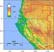
| Highest point | Mont Bengoué Mont Bengoué Mont Bengoué is the highest mountain in Gabon. Mont Bengoué is located in the Ogooué-Ivindo Province.... , 1070m at 00°57′21"N 13°41′09"E |
| Lowest point | Atlantic Ocean Atlantic Ocean The Atlantic Ocean is the second-largest of the world's oceanic divisions. With a total area of about , it covers approximately 20% of the Earth's surface and about 26% of its water surface area... , 0 m |
| Longest river | Ogooué River Ogooué River The Ogooué , some 1,200 km long, is the principal river of Gabon in west central Africa. Its watershed drains nearly the entire country of Gabon, with some tributaries reaching into the Republic of the Congo, Cameroon, and Equatorial Guinea.... |
| Largest inland body of water | ?? |
| Land Use - Arable land - Permanent crops - Permanent pastures - Forests and woodlands - Other |
1 % 1 % 18 % 77 % 3 % (1993 est.) |
| Climate Climate Climate encompasses the statistics of temperature, humidity, atmospheric pressure, wind, rainfall, atmospheric particle count and other meteorological elemental measurements in a given region over long periods... : |
Tropical Tropics The tropics is a region of the Earth surrounding the Equator. It is limited in latitude by the Tropic of Cancer in the northern hemisphere at approximately N and the Tropic of Capricorn in the southern hemisphere at S; these latitudes correspond to the axial tilt of the Earth... |
| Natural resources | Petroleum Petroleum Petroleum or crude oil is a naturally occurring, flammable liquid consisting of a complex mixture of hydrocarbons of various molecular weights and other liquid organic compounds, that are found in geologic formations beneath the Earth's surface. Petroleum is recovered mostly through oil drilling... , manganese Manganese Manganese is a chemical element, designated by the symbol Mn. It has the atomic number 25. It is found as a free element in nature , and in many minerals... , uranium Uranium Uranium is a silvery-white metallic chemical element in the actinide series of the periodic table, with atomic number 92. It is assigned the chemical symbol U. A uranium atom has 92 protons and 92 electrons, of which 6 are valence electrons... , gold Gold Gold is a chemical element with the symbol Au and an atomic number of 79. Gold is a dense, soft, shiny, malleable and ductile metal. Pure gold has a bright yellow color and luster traditionally considered attractive, which it maintains without oxidizing in air or water. Chemically, gold is a... , timber Timber Timber may refer to:* Timber, a term common in the United Kingdom and Australia for wood materials * Timber, Oregon, an unincorporated community in the U.S... , iron ore, hydropower Hydropower Hydropower, hydraulic power, hydrokinetic power or water power is power that is derived from the force or energy of falling water, which may be harnessed for useful purposes. Since ancient times, hydropower has been used for irrigation and the operation of various mechanical devices, such as... |
| Environmental issues | deforestation Deforestation Deforestation is the removal of a forest or stand of trees where the land is thereafter converted to a nonforest use. Examples of deforestation include conversion of forestland to farms, ranches, or urban use.... , poaching Poaching Poaching is the illegal taking of wild plants or animals contrary to local and international conservation and wildlife management laws. Violations of hunting laws and regulations are normally punishable by law and, collectively, such violations are known as poaching.It may be illegal and in... |
Gabon
Gabon
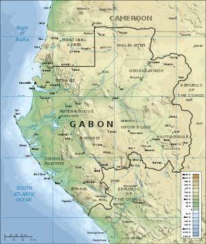
Gabon , officially the Gabonese Republic is a state in west central Africa sharing borders with Equatorial Guinea to the northwest, Cameroon to the north, and with the Republic of the Congo curving around the east and south. The Gulf of Guinea, an arm of the Atlantic Ocean is to the west...
is a country in West Africa
West Africa
West Africa or Western Africa is the westernmost region of the African continent. Geopolitically, the UN definition of Western Africa includes the following 16 countries and an area of approximately 5 million square km:-Flags of West Africa:...
, lying along the Atlantic Ocean
Atlantic Ocean
The Atlantic Ocean is the second-largest of the world's oceanic divisions. With a total area of about , it covers approximately 20% of the Earth's surface and about 26% of its water surface area...
, just south of the Bight of Biafra.
Borders
Gabon has a total of 2,551 km of international boundaries. It borders Equatorial GuineaEquatorial Guinea
Equatorial Guinea, officially the Republic of Equatorial Guinea where the capital Malabo is situated.Annobón is the southernmost island of Equatorial Guinea and is situated just south of the equator. Bioko island is the northernmost point of Equatorial Guinea. Between the two islands and to the...
(350 km) and Cameroon
Cameroon
Cameroon, officially the Republic of Cameroon , is a country in west Central Africa. It is bordered by Nigeria to the west; Chad to the northeast; the Central African Republic to the east; and Equatorial Guinea, Gabon, and the Republic of the Congo to the south. Cameroon's coastline lies on the...
(298 km) to the north and the Republic of the Congo
Republic of the Congo
The Republic of the Congo , sometimes known locally as Congo-Brazzaville, is a state in Central Africa. It is bordered by Gabon, Cameroon, the Central African Republic, the Democratic Republic of the Congo , the Angolan exclave province of Cabinda, and the Gulf of Guinea.The region was dominated by...
(1,903 km) to the west and south. Gabon lies on the equator
Equator
An equator is the intersection of a sphere's surface with the plane perpendicular to the sphere's axis of rotation and containing the sphere's center of mass....
.
Maritime claims:
- Contiguous zone: 24 nmi (44.4 km)
- Exclusive economic zone: 200 nmi (370.4 km)
- Territorial sea: 12 nmi (22.2 km)
Climate
Gabon has the moist, hot climate typical of tropical regions. The hottest month is January, with an average high at LibrevilleLibreville
Libreville is the capital and largest city of Gabon, in west central Africa. The city is a port on the Komo River, near the Gulf of Guinea, and a trade center for a timber region. As of 2005, it has a population of 578,156.- History :...
of 31 °C (87.8 °F) and an average low of 23 °C (73.4 °F). Average July temperatures in the capital range between 20 and 28 °C (68 and 82.4 °F). From June to September there is virtually no rain but high humidity; there is occasional rain in December and January. During the remaining months, rainfall is heavy. The excessive rainfall is caused by the condensation of moist air resulting from the meeting, directly off the coast, of the cold Benguela Current
Benguela Current
The Benguela Current is the broad, northward flowing ocean current that forms the eastern portion of the South Atlantic Ocean gyre. The current extends from roughly Cape Point in the south, to the position of the Angola-Benguela Front in the north, at around 16°S. The current is driven by the...
from the south and the warm Guinea Current
Guinea Current
The Guinea Current is a slow warm water current that flows to the east along the Guinea coast of West Africa. It has some similarity to the Equatorial Counter Current in the Indian and Pacific Oceans....
from the north. At Libreville, the average annual rainfall is more than 2540 mm (100 in). Farther north on the coast, it is 3810 mm (150 in).
Terrain
Narrow coastal plain with patches of Central African mangrovesCentral African mangroves
The Central African mangroves ecoregion consists of the largest area of mangrove swamp in Africa, located on the coasts of West Africa, mainly in Nigeria.-Location and description:...
; hilly interior; savanna
Savanna
A savanna, or savannah, is a grassland ecosystem characterized by the trees being sufficiently small or widely spaced so that the canopy does not close. The open canopy allows sufficient light to reach the ground to support an unbroken herbaceous layer consisting primarily of C4 grasses.Some...
in east and south.
- Irrigated land: 40 km² (1993 est.)
Environment
International agreements:Party to: Biodiversity
Biodiversity
Biodiversity is the degree of variation of life forms within a given ecosystem, biome, or an entire planet. Biodiversity is a measure of the health of ecosystems. Biodiversity is in part a function of climate. In terrestrial habitats, tropical regions are typically rich whereas polar regions...
, Climate Change
United Nations Framework Convention on Climate Change
The United Nations Framework Convention on Climate Change is an international environmental treaty produced at the United Nations Conference on Environment and Development , informally known as the Earth Summit, held in Rio de Janeiro from June 3 to 14, 1992...
, Desertification
Desertification
Desertification is the degradation of land in drylands. Caused by a variety of factors, such as climate change and human activities, desertification is one of the most significant global environmental problems.-Definitions:...
, Endangered Species
Endangered species
An endangered species is a population of organisms which is at risk of becoming extinct because it is either few in numbers, or threatened by changing environmental or predation parameters...
, Law of the Sea
Law of the sea
Law of the sea may refer to:* United Nations Convention on the Law of the Sea* Admiralty law* The Custom of the Sea...
, Marine Dumping, Nuclear Test Ban, Ozone Layer Protection, Ship Pollution, Tropical Timber 83, Tropical Timber 94, Wetlands, International Convention for the Regulation of Whaling
International Convention for the Regulation of Whaling
The International Convention for the Regulation of Whaling is an international environmental agreement signed in 1946 in order to "provide for the proper conservation of whale stocks and thus make possible the orderly development of the whaling industry"...
Signed, but not ratified: None of the selected agreements
Extreme points
This is a list of the extreme points of the GabonGabon
Gabon , officially the Gabonese Republic is a state in west central Africa sharing borders with Equatorial Guinea to the northwest, Cameroon to the north, and with the Republic of the Congo curving around the east and south. The Gulf of Guinea, an arm of the Atlantic Ocean is to the west...
, the points that are farther north, south, east or west than any other location.
- Northern-most point - unnamed location on the border with CameroonCameroonCameroon, officially the Republic of Cameroon , is a country in west Central Africa. It is bordered by Nigeria to the west; Chad to the northeast; the Central African Republic to the east; and Equatorial Guinea, Gabon, and the Republic of the Congo to the south. Cameroon's coastline lies on the...
on the Ntem riverNtem RiverThe Ntem River is a border river in Cameroon, Equatorial Guinea and Gabon. It rises in Gabon, but flows into the Atlantic Ocean in Cameroon. A tributary continues along the border towards the east.- Towns :* Campo* Minvoul, Gabon...
, Woleu-NtemWoleu-NtemWoleu-Ntem is one of Gabon's nine provinces. It covers an area of 38,465 km². The provincial capital is Oyem.As Woleu-Ntem is the most northerly province of Gabon, it is the only province that borders Cameroon, as well as bordering the Republics of Equatorial Guinea and of the Congo...
province - Eastern-most point - unnamed location on the border with the Republic of Congo immediately south-west of the Congolese village of Mbeyi-Mbola, Haut-OgoouéHaut-OgoouéHaut-Ogooué is one of Gabon's nine provinces. It is named after the Ogooué River. It covers an area of 36,547 km². The provincial capital is Franceville. One of its primary industries is mining, with manganese, gold and uranium being found in the region. The uranium-bearing mineral Francevillite...
province - Southern-most point - the point at which the border with the Republic of Congo enters the Atlantic OceanAtlantic OceanThe Atlantic Ocean is the second-largest of the world's oceanic divisions. With a total area of about , it covers approximately 20% of the Earth's surface and about 26% of its water surface area...
, Nyanga Province - Western-most point - the north-west point of Cape LopezCape LopezCape Lopez is a 55 km-long peninsula on the coast of west central Africa, in the country of Gabon. It separates the Gulf of Guinea from the South Atlantic Ocean, and is located at latitude -0.63° and longitude 8.7° . Lying in the delta of the Ogooué River, it shelters the seaport of Port-Gentil...
, Ogooué Maritime province