
Geography of French Polynesia
Encyclopedia
This article describes the geography
of French Polynesia
.
Location:
Geographic coordinates:
Map references:
Area:
Land boundaries:
Coastline:
Maritime claims:
Climate:
Terrain:
Elevation extremes:
Natural resources:
Land use:
Irrigated land:
Natural hazards:
Environment - current issues:
Geography - note:
Geography
Geography is the science that studies the lands, features, inhabitants, and phenomena of Earth. A literal translation would be "to describe or write about the Earth". The first person to use the word "geography" was Eratosthenes...
of French Polynesia
French Polynesia
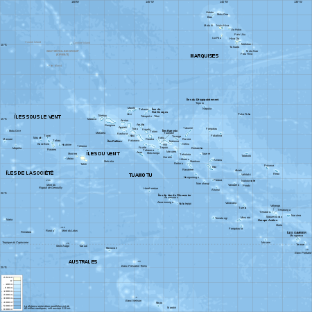
French Polynesia is an overseas country of the French Republic . It is made up of several groups of Polynesian islands, the most famous island being Tahiti in the Society Islands group, which is also the most populous island and the seat of the capital of the territory...
.
Location:
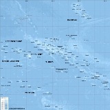
- OceaniaOceaniaOceania is a region centered on the islands of the tropical Pacific Ocean. Conceptions of what constitutes Oceania range from the coral atolls and volcanic islands of the South Pacific to the entire insular region between Asia and the Americas, including Australasia and the Malay Archipelago...
, archipelagoArchipelagoAn archipelago , sometimes called an island group, is a chain or cluster of islands. The word archipelago is derived from the Greek ἄρχι- – arkhi- and πέλαγος – pélagos through the Italian arcipelago...
in the South Pacific OceanPacific OceanThe Pacific Ocean is the largest of the Earth's oceanic divisions. It extends from the Arctic in the north to the Southern Ocean in the south, bounded by Asia and Australia in the west, and the Americas in the east.At 165.2 million square kilometres in area, this largest division of the World...
, about half way between South AmericaSouth AmericaSouth America is a continent situated in the Western Hemisphere, mostly in the Southern Hemisphere, with a relatively small portion in the Northern Hemisphere. The continent is also considered a subcontinent of the Americas. It is bordered on the west by the Pacific Ocean and on the north and east...
and AustraliaAustraliaAustralia , officially the Commonwealth of Australia, is a country in the Southern Hemisphere comprising the mainland of the Australian continent, the island of Tasmania, and numerous smaller islands in the Indian and Pacific Oceans. It is the world's sixth-largest country by total area...
Geographic coordinates:
- 15°00′S 140°00′W
Map references:
- Oceania
Area:
- Total: 4,167 km² (Around 130 islands)
- Land: 3,660 km²
- Water: 507 km²
Land boundaries:
- 0 km
Coastline:
- 2,525 km
Maritime claims:
- Exclusive economic zone: 200 nmNautical mileThe nautical mile is a unit of length that is about one minute of arc of latitude along any meridian, but is approximately one minute of arc of longitude only at the equator...
- Territorial sea: 12 nm
Climate:
- Tropical, but moderate
Terrain:
- Mixture of rugged high islands and low islands with reefs
Elevation extremes:
- Lowest point: Pacific Ocean 0 m
- Highest point: Mont OrohenaMont OrohenaMont Orohena is a mountain of 2,241 m in central Tahiti in French Polynesia in the south Pacific. It is the highest point of French Polynesia. Mont Orohena is an extinct volcano.-References:...
( TahitiTahitiTahiti is the largest island in the Windward group of French Polynesia, located in the archipelago of the Society Islands in the southern Pacific Ocean. It is the economic, cultural and political centre of French Polynesia. The island was formed from volcanic activity and is high and mountainous...
) 2,241 m
Natural resources:
- Timber, fish, cobaltCobaltCobalt is a chemical element with symbol Co and atomic number 27. It is found naturally only in chemically combined form. The free element, produced by reductive smelting, is a hard, lustrous, silver-gray metal....
, hydropowerHydropowerHydropower, hydraulic power, hydrokinetic power or water power is power that is derived from the force or energy of falling water, which may be harnessed for useful purposes. Since ancient times, hydropower has been used for irrigation and the operation of various mechanical devices, such as...
Land use:
- Arable land: 1%
- Permanent crops: 6%
- Permanent pastures: 5%
- Forests and woodland: 31%
- Other: 57% (1993 est.)
Irrigated land:
- NA km²
Natural hazards:
- Occasional cyclonic storms in January
Environment - current issues:
Geography - note:
- Includes five archipelagoes; MakateaMakateaMakatea, or Mangaia-te-vai-tamae, is a raised coral atoll in the northwestern part of the Tuamotus. It is located 79 km southwest from Rangiroa to the west of the Palliser group. It is surrounded by spectacular cliffs, rising to a plateau 80 meters above the sea level. This island is...
in French Polynesia is one of the three great phosphate rock islands in the Pacific Ocean - the others are BanabaBanaba IslandBanaba Island , an island in the Pacific Ocean, is a solitary raised coral island west of the Gilbert Island chain and 300 km east of Nauru. It is part of the Republic of Kiribati. It has an area of 6.5 km², and the highest point on the island is also the highest point in Kiribati, at 81...
(Ocean Island) in KiribatiKiribatiKiribati , officially the Republic of Kiribati, is an island nation located in the central tropical Pacific Ocean. The permanent population exceeds just over 100,000 , and is composed of 32 atolls and one raised coral island, dispersed over 3.5 million square kilometres, straddling the...
and NauruNauruNauru , officially the Republic of Nauru and formerly known as Pleasant Island, is an island country in Micronesia in the South Pacific. Its nearest neighbour is Banaba Island in Kiribati, to the east. Nauru is the world's smallest republic, covering just...