
Geography of Estonia
Encyclopedia

Latitude
In geography, the latitude of a location on the Earth is the angular distance of that location south or north of the Equator. The latitude is an angle, and is usually measured in degrees . The equator has a latitude of 0°, the North pole has a latitude of 90° north , and the South pole has a...
and 21.5 and 28.1 longitude
Longitude
Longitude is a geographic coordinate that specifies the east-west position of a point on the Earth's surface. It is an angular measurement, usually expressed in degrees, minutes and seconds, and denoted by the Greek letter lambda ....
, Estonia
Estonia
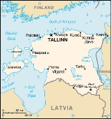
Estonia , officially the Republic of Estonia , is a state in the Baltic region of Northern Europe. It is bordered to the north by the Gulf of Finland, to the west by the Baltic Sea, to the south by Latvia , and to the east by Lake Peipsi and the Russian Federation . Across the Baltic Sea lies...
lies on the eastern shores of the Baltic Sea
Baltic Sea
The Baltic Sea is a brackish mediterranean sea located in Northern Europe, from 53°N to 66°N latitude and from 20°E to 26°E longitude. It is bounded by the Scandinavian Peninsula, the mainland of Europe, and the Danish islands. It drains into the Kattegat by way of the Øresund, the Great Belt and...
on the level northwestern part of the rising east European platform. It borders the Gulf of Finland
Gulf of Finland
The Gulf of Finland is the easternmost arm of the Baltic Sea. It extends between Finland and Estonia all the way to Saint Petersburg in Russia, where the river Neva drains into it. Other major cities around the gulf include Helsinki and Tallinn...
, between Latvia
Latvia
Latvia , officially the Republic of Latvia , is a country in the Baltic region of Northern Europe. It is bordered to the north by Estonia , to the south by Lithuania , to the east by the Russian Federation , to the southeast by Belarus and shares maritime borders to the west with Sweden...
and Russia
Russia
Russia or , officially known as both Russia and the Russian Federation , is a country in northern Eurasia. It is a federal semi-presidential republic, comprising 83 federal subjects...
. Average elevation reaches only 50 m (164 ft).
The climate is maritime, wet, with moderate winters and cool summers. Oil shale
Oil shale
Oil shale, an organic-rich fine-grained sedimentary rock, contains significant amounts of kerogen from which liquid hydrocarbons called shale oil can be produced...
and limestone
Limestone
Limestone is a sedimentary rock composed largely of the minerals calcite and aragonite, which are different crystal forms of calcium carbonate . Many limestones are composed from skeletal fragments of marine organisms such as coral or foraminifera....
deposits, along with forests which cover 47% of the land, play key economic roles in this generally resource-poor country. Estonia boasts over 1,500 lakes, numerous bog
Bog
A bog, quagmire or mire is a wetland that accumulates acidic peat, a deposit of dead plant material—often mosses or, in Arctic climates, lichens....
s, and 3,794 kilometers of coastline marked by numerous bays, straits, and inlets. Tallinn
Tallinn
Tallinn is the capital and largest city of Estonia. It occupies an area of with a population of 414,940. It is situated on the northern coast of the country, on the banks of the Gulf of Finland, south of Helsinki, east of Stockholm and west of Saint Petersburg. Tallinn's Old Town is in the list...
's Muuga port
Port of Muuga
The Port of Muuga is the largest cargo port in Estonia, located on the southern coast of the Gulf of Finland, 13 km northeast of the capital Tallinn, in Maardu. It is one of the few ice-free ports in northernmost Europe....
offers one of Europe's finest warm-water harbor facilities.
Estonia's strategic location has precipitated many wars that were fought on its territory between other rival powers at its expense. In 1944, under Soviet
Soviet Union
The Soviet Union , officially the Union of Soviet Socialist Republics , was a constitutionally socialist state that existed in Eurasia between 1922 and 1991....
occupation, the Jaanilinn
Ivangorod
Ivangorod is a town in Leningrad Oblast, Russia, situated on the right bank of the Narva River by the Russian-Estonian border, west of St. Petersburg. Population: The town is known for the Ivangorod fortress....
and Petseri
Pechory
Pechory : Petseri; ) is a town and the administrative center of Pechorsky District of Pskov Oblast, Russia. Population: The population includes a few hundred ethnic Estonians.The town is famous for the Russian Orthodox Pskovo-Pechersky Monastery....
regions were annexed to Russian SFSR territory. The legal status of these territories has not been fully settled yet, though neither Estonia or Russia has not any territorial claims.
Geographic coordinates: 59°00′N 26°00′E)
Geographic features
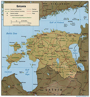
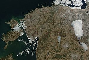
Estonia is a flat country covering 45226 square kilometre. Estonia has a long, shallow coastline (1393 km (866 mi)) along the Baltic Sea, with 1,520 islands dotting the shore. The two largest islands are SaaremaaSaaremaa
Saaremaa is the largest island in Estonia, measuring 2,673 km². The main island of Saare County, it is located in the Baltic Sea, south of Hiiumaa island, and belongs to the West Estonian Archipelago...
(literally, island land), at 2673 square kilometre, and Hiiumaa, at 989 square kilometre. The two islands are favorite Estonian vacation spots. The country's highest point, Suur Munamägi (Egg Mountain), is in the hilly southeast and reaches 318 m (1,043 ft) above sea level. Estonia is covered by about 18000 square kilometre of forest. Arable land amounts to about 9260 square kilometre. Meadows cover about 2520 square kilometre, and pastureland covers about 1810 square kilometre. There are more than 1,400 natural and artificial lakes in Estonia. The largest of them, Lake Peipus
Lake Peipus
Lake Peipus, ) is the biggest transboundary lake in Europe on the border between Estonia and Russia.The lake is the fifth largest in Europe after Lake Ladoga and Lake Onega in Russia north of St...
(3555 square kilometre), forms much of the border between Estonia and Russia. Located in central Estonia, Võrtsjärv
Võrtsjärv
Lake Võrtsjärv is a lake in southern Estonia with an area of 270 km² . It is the second largest lake of Estonia. The shallow lake is 33.7 m above sea level. The river Emajõgi flows from Lake Võrtsjärv to Lake Peipus.-External links:**...
is the second-largest lake (270 square kilometre). The Narva
Narva River
The Narva is a river flowing into the Baltic Sea, the largest river in Estonia. Draining Lake Peipsi, the river forms the border of Estonia and Russia and flows through the towns of Narva/Ivangorod and Narva-Jõesuu into Narva Bay. Though the river is only 77 km long, in terms of volume...
and Emajõgi
Emajõgi
The Emajõgi is a river in Estonia which flows from Lake Võrtsjärv through Tartu County into Lake Peipus, crossing the city of Tartu for 10 km. It has a length of 100 km...
are among the most important of the country's many rivers.
A small, recent cluster of meteorite craters, the largest of which is called Kaali
Kaali crater
Kaali is a group of 9 meteorite craters located on the Estonian island of Saaremaa. Formed in the 7th century BC or about 4000 years ago , it is one of the most recent craters created by an impact event and the only known major impact event that has occurred in a populated area.Prior to the 1930s,...
are found near Saaremaa
Saaremaa
Saaremaa is the largest island in Estonia, measuring 2,673 km². The main island of Saare County, it is located in the Baltic Sea, south of Hiiumaa island, and belongs to the West Estonian Archipelago...
, Estonia. It is thought that the impact was witnessed by the Iron Age inhabitants of the area.
Estonia has a temperate climate, with four seasons of near-equal length. Average temperatures range from 16.3 °C (61.3 °F) on the Baltic islands to 17.1 °C (62.8 °F) inland in July, the warmest month, and from −3.5 °C on the Baltic islands to −7.6 °C inland in February, the coldest month. Precipitation averages 568 mm (22.4 in) per year and is heaviest in late summer.
Estonia's land border with Latvia runs 267 km (166 mi); the Russian border runs 290 km (180 mi). From 1920 to 1945, Estonia's border with Russia, set by the 1920 Tartu Peace Treaty, extended beyond the Narva River in the northeast and beyond the town of Petseri in the southeast. This territory, amounting to some 2300 square kilometre, was incorporated into Russia by Joseph Stalin
Joseph Stalin
Joseph Vissarionovich Stalin was the Premier of the Soviet Union from 6 May 1941 to 5 March 1953. He was among the Bolshevik revolutionaries who brought about the October Revolution and had held the position of first General Secretary of the Communist Party of the Soviet Union's Central Committee...
at the end of World War II
World War II
World War II, or the Second World War , was a global conflict lasting from 1939 to 1945, involving most of the world's nations—including all of the great powers—eventually forming two opposing military alliances: the Allies and the Axis...
.
Environmental issues
One of the most burdensome legacies of the Soviet era is widespread environmental pollution. The worst offender in this regard was the Soviet army. Across military installations covering more than 800 km² of Estonian territory, the army dumped hundreds of thousands of tons of jet fuel into the ground, improperly disposed of toxic chemicals, and discarded outdated explosives and weapons in coastal and inland waters. In the 1990s, during the army's withdrawal from Estonia, extensive damage was done to discarded buildings and equipment. In October 1993, the Estonian Ministry of Environment issued a preliminary report summing up part of the degradation it had surveyed thus far. The report described the worst damage as having been done to Estonia's topsoil and underground water supply by the systematic dumping of jet fuel at six Soviet army air bases. At the air base near Tapa, site of the worst damage, officials estimated that six square kilometers of land were covered by a layer of fuel; 11 square kilometers of underground water were said to be contaminated. The water in the surrounding area was undrinkable. With Danish help, Estonian crews began cleaning up the site, although they estimated the likely cost to be as much as EKR4 million. The Ministry of Environment assigned a monetary cost of more than EKR10 billion to the damage to the country's topsoil and water supply. However, the ministry was able to allocate only EKR5 million in 1993 for cleanup operations.In a 1992 government report to the United Nations Conference on the Environment and Development, Estonia detailed other major environmental concerns. For instance, for several consecutive years Estonia had led the world in the production of sulfur dioxide per capita. Nearly 75 % of Estonia's air pollution was reported to come from two oil shale-based thermal power stations operating near Narva
Narva Power Plants
The Narva Power Plants are a power generation complex in Narva in Estonia, near the border with Leningrad Oblast, Russia. The complex consists of the world's two largest oil shale-fired thermal power plants, Eesti Power Plant and Balti Power Plant . In 2007, Narva Power Plants generated about...
. The mining of oil shale
Oil shale in Estonia
Oil shale in Estonia is an important resource for the national economy. Estonia's oil shale deposits account for just 17% of total deposits in the European Union but the country generates 90% of its power from this source...
in northeastern Estonia has also left large mounds of limestone tailings
Tailings
Tailings, also called mine dumps, slimes, tails, leach residue, or slickens, are the materials left over after the process of separating the valuable fraction from the uneconomic fraction of an ore...
and ash dotting the region. Near the town of Sillamäe
Sillamäe
Sillamäe is a town in Ida-Viru County in the northern part of Estonia, on the southern coast of the Gulf of Finland. It has a population of 16,183 and covers an area of 10.54 km²...
, site of a former uranium enrichment plant, about 1,200 tons of uranium and about 750 tons of thorium had been dumped into a reservoir on the shore of the Gulf of Finland. This was said to have caused severe health problems among area residents. In the coastal town of Paldiski, the removal of waste left by Soviet army nuclear reactors was also a major concern. The combined cost of environmental cleanup at both towns was put at more than EKR3.5 billion.
Natural hazards: flooding occurs frequently in the spring in certain areas
Environment – current issues: air heavily polluted with sulfur dioxide
Sulfur dioxide
Sulfur dioxide is the chemical compound with the formula . It is released by volcanoes and in various industrial processes. Since coal and petroleum often contain sulfur compounds, their combustion generates sulfur dioxide unless the sulfur compounds are removed before burning the fuel...
from oil-shale burning power plants in northeast; contamination of soil and groundwater with petroleum
Petroleum
Petroleum or crude oil is a naturally occurring, flammable liquid consisting of a complex mixture of hydrocarbons of various molecular weights and other liquid organic compounds, that are found in geologic formations beneath the Earth's surface. Petroleum is recovered mostly through oil drilling...
products, chemicals at former Soviet military bases; Estonia has more than 1,400 natural and artificial lakes, the smaller of which in agricultural areas are heavily affected by organic waste; coastal sea water is polluted in many locations. The HBV
HBV hydrology model
The HBV hydrology model, or Hydrologiska Byråns Vattenbalansavdelning model, is a computer simulation used to analyze river discharge and water pollution...
hydrological transport model
Hydrological transport model
An hydrological transport model is a mathematical model used to simulate river or stream flow and calculate water quality parameters. These models generally came into use in the 1960s and 1970s when demand for numerical forecasting of water quality was driven by environmental legislation, and at...
has been used to analyze water pollution
Water pollution
Water pollution is the contamination of water bodies . Water pollution occurs when pollutants are discharged directly or indirectly into water bodies without adequate treatment to remove harmful compounds....
issues in Estonia's rivers and in the Baltic Sea
Baltic Sea
The Baltic Sea is a brackish mediterranean sea located in Northern Europe, from 53°N to 66°N latitude and from 20°E to 26°E longitude. It is bounded by the Scandinavian Peninsula, the mainland of Europe, and the Danish islands. It drains into the Kattegat by way of the Øresund, the Great Belt and...
Environment – international agreements:
party to: Biodiversity, Climate Change, Endangered Species, Hazardous Wastes, Ship Pollution, Ozone Layer Protection, Wetlands
signed, but not ratified: Climate Change-Kyoto Protocol
Kyoto Protocol
The Kyoto Protocol is a protocol to the United Nations Framework Convention on Climate Change , aimed at fighting global warming...
Area and boundaries
Area:total: 45,226 km²
land: 43,211 km²
water: 2,015 km²
note: includes 1,520 islands in the Baltic Sea
Land boundaries:
total: 633 km
border countries: Latvia 339 km, Russia 294 km
Coastline: 3,794 km
Maritime claims:
exclusive economic zone: limits fixed in coordination with neighboring states
territorial sea: 12 nmi (22.2 km; 13.8 mi)
Elevation extremes:
lowest point: Baltic Sea 0 m
highest point: Suur Munamägi
Suur Munamägi
Suur Munamägi is the highest peak in Estonia , reaching above sea level. It is located near the village of Haanja, in Võru County in the south-eastern corner of Estonia, close to the borders of both Latvia and Russia...
318 m
Resources and land use
Natural resources: oil shaleOil shale
Oil shale, an organic-rich fine-grained sedimentary rock, contains significant amounts of kerogen from which liquid hydrocarbons called shale oil can be produced...
(kukersite
Kukersite
Kukersite is a marine type oil shale of Ordovician age, found in the Baltic Oil Shale Basin in Estonia and North-West Russia. It was named after Kukruse settlement in Estonia in 1917 by Russian paleontologist Mikhail Zalessky....
), peat
Peat
Peat is an accumulation of partially decayed vegetation matter or histosol. Peat forms in wetland bogs, moors, muskegs, pocosins, mires, and peat swamp forests. Peat is harvested as an important source of fuel in certain parts of the world...
, phosphorite
Phosphorite
Phosphorite, phosphate rock or rock phosphate is a non-detrital sedimentary rock which contains high amounts of phosphate bearing minerals. The phosphate content of phosphorite is at least 15 to 20% which is a large enrichment over the typical sedimentary rock content of less than 0.2%...
, cambrian blue clay, limestone
Limestone
Limestone is a sedimentary rock composed largely of the minerals calcite and aragonite, which are different crystal forms of calcium carbonate . Many limestones are composed from skeletal fragments of marine organisms such as coral or foraminifera....
, dolomite
Dolomite
Dolomite is a carbonate mineral composed of calcium magnesium carbonate CaMg2. The term is also used to describe the sedimentary carbonate rock dolostone....
, arable land
Arable land
In geography and agriculture, arable land is land that can be used for growing crops. It includes all land under temporary crops , temporary meadows for mowing or pasture, land under market and kitchen gardens and land temporarily fallow...
Land use:
arable land: 25%
permanent crops: 0%
permanent pastures: 11%
forests and woodland: 44%
other: 20% (1996 est.)