

Geography of Eritrea
Encyclopedia
Eritrea
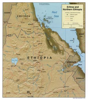
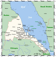
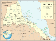
Eritrea , officially the State of Eritrea, is a country in the Horn of Africa. Eritrea derives it's name from the Greek word Erethria, meaning 'red land'. The capital is Asmara. It is bordered by Sudan in the west, Ethiopia in the south, and Djibouti in the southeast...
is located in the Horn of Africa
Horn of Africa
The Horn of Africa is a peninsula in East Africa that juts hundreds of kilometers into the Arabian Sea and lies along the southern side of the Gulf of Aden. It is the easternmost projection of the African continent...
and is bordered on the northeast and east by the Red Sea
Red Sea
The Red Sea is a seawater inlet of the Indian Ocean, lying between Africa and Asia. The connection to the ocean is in the south through the Bab el Mandeb strait and the Gulf of Aden. In the north, there is the Sinai Peninsula, the Gulf of Aqaba, and the Gulf of Suez...
, on the west and northwest by Sudan
Sudan
Sudan , officially the Republic of the Sudan , is a country in North Africa, sometimes considered part of the Middle East politically. It is bordered by Egypt to the north, the Red Sea to the northeast, Eritrea and Ethiopia to the east, South Sudan to the south, the Central African Republic to the...
, on the south by Ethiopia
Ethiopia
Ethiopia , officially known as the Federal Democratic Republic of Ethiopia, is a country located in the Horn of Africa. It is the second-most populous nation in Africa, with over 82 million inhabitants, and the tenth-largest by area, occupying 1,100,000 km2...
, and on the southeast by Djibouti
Djibouti
Djibouti , officially the Republic of Djibouti , is a country in the Horn of Africa. It is bordered by Eritrea in the north, Ethiopia in the west and south, and Somalia in the southeast. The remainder of the border is formed by the Red Sea and the Gulf of Aden at the east...
. The country has a high central plateau that varies from 1800 to 3000 m (5,905.5 to 9,842.5 ft) above sea level. A coastal plain, western lowlands, and some 350 islands comprise the remainder of Eritrea's land mass. Eritrea has no year-round rivers.
Climate
Hot, dry desert strip along Red Sea coast; cooler and wetter in the central highlands (up to 610 mm (24 in) of rainfall annually); semiarid in western hills and lowlands; rainfall heaviest during June–September except in coastal desert. The climate is temperate in the mountains and hot in the lowlands. AsmaraAsmara
Asmara is the capital city and largest settlement in Eritrea, home to a population of around 579,000 people...
, the capital, is about 2400 metres (7,874 ft) above sea level. Maximum temperature is 26 °C (78.8 °F). The weather is usually sunny and dry, with the short or belg rains occurring February–April and the big or meher rains beginning in late June and ending in mid-September.
Data
Location:Eastern Africa
Africa
Africa is the world's second largest and second most populous continent, after Asia. At about 30.2 million km² including adjacent islands, it covers 6% of the Earth's total surface area and 20.4% of the total land area...
, bordering the Red Sea
Red Sea
The Red Sea is a seawater inlet of the Indian Ocean, lying between Africa and Asia. The connection to the ocean is in the south through the Bab el Mandeb strait and the Gulf of Aden. In the north, there is the Sinai Peninsula, the Gulf of Aqaba, and the Gulf of Suez...
, between Djibouti
Djibouti
Djibouti , officially the Republic of Djibouti , is a country in the Horn of Africa. It is bordered by Eritrea in the north, Ethiopia in the west and south, and Somalia in the southeast. The remainder of the border is formed by the Red Sea and the Gulf of Aden at the east...
and Sudan
Sudan
Sudan , officially the Republic of the Sudan , is a country in North Africa, sometimes considered part of the Middle East politically. It is bordered by Egypt to the north, the Red Sea to the northeast, Eritrea and Ethiopia to the east, South Sudan to the south, the Central African Republic to the...
, also bordering on Ethiopia
Ethiopia
Ethiopia , officially known as the Federal Democratic Republic of Ethiopia, is a country located in the Horn of Africa. It is the second-most populous nation in Africa, with over 82 million inhabitants, and the tenth-largest by area, occupying 1,100,000 km2...
.
Geographic coordinates: 15°00′N 39°00′E)
Map references:
Africa
Area:
total:
124 320 km²
land:
121 320 km²
water:
4000 km²
Area - comparative:
slightly larger than Pennsylvania
Land boundaries:
total:
1 630 km
border countries:
Djibouti
Djibouti
Djibouti , officially the Republic of Djibouti , is a country in the Horn of Africa. It is bordered by Eritrea in the north, Ethiopia in the west and south, and Somalia in the southeast. The remainder of the border is formed by the Red Sea and the Gulf of Aden at the east...
113 km, Ethiopia
Ethiopia
Ethiopia , officially known as the Federal Democratic Republic of Ethiopia, is a country located in the Horn of Africa. It is the second-most populous nation in Africa, with over 82 million inhabitants, and the tenth-largest by area, occupying 1,100,000 km2...
912 km, Sudan
Sudan
Sudan , officially the Republic of the Sudan , is a country in North Africa, sometimes considered part of the Middle East politically. It is bordered by Egypt to the north, the Red Sea to the northeast, Eritrea and Ethiopia to the east, South Sudan to the south, the Central African Republic to the...
605 km
Note that the border between Eritrea and Ethiopia is disputed.
Coastline:
2 234 km total; mainland on Red Sea 1 151 km, islands in Red Sea 1 083 km
Maritime claims:
NA
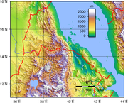
Terrain:
dominated by extension of Ethiopian north-south trending highlands, descending on the east to a coastal desert plain, on the northwest to hilly terrain and on the southwest to flat-to-rolling plains
Ecoregions:
Most of Eritrea's coast is part of the Ethiopian xeric grasslands and shrublands
Ethiopian xeric grasslands and shrublands
The Ethiopian xeric grasslands and shrublands ecoregion is a semi-desert strip on or near the Red Sea and the Gulf of Oman coasts in Eritrea, Ethiopia, Djibouti and Somaliland.-Location and description:...
semi-desert ecoregion
Ecoregion
An ecoregion , sometimes called a bioregion, is an ecologically and geographically defined area that is smaller than an ecozone and larger than an ecosystem. Ecoregions cover relatively large areas of land or water, and contain characteristic, geographically distinct assemblages of natural...
. The southern part of the Red Sea coast, along with the Red Sea coast of Djibouti, has been described as the Eritrean coastal desert
Eritrean coastal desert
The Eritrean coastal desert ecoregion is a a harsh sand and gravel strip along the southern part of the coast of Eritrea and the Red Sea coast of Djibouti...
, a harsh sand and gravel coastal strip covered in dune grasses and shrubs that is important as a channel for the mass migration of birds of prey.
Elevation extremes:
lowest point:
near Lake Kulul
Lake Kulul
Lake Kulul is the lowest point in Eritrea. Located in the Northern Red Sea Region, Lake Kulul lies in the Eritrean portion of the Afar Depression....
within the Afar Depression
Afar Depression
The Afar Triangle is a geological depression that is caused by the Afar Triple Junction which is part of the Great Rift Valley. It overlaps Eritrea, Djibouti and the entire Afar Region of Ethiopia. The Afar Triangle includes the Danakil Depression and the lowest point in Africa, Lake Asal...
−75 m
highest point:
Soira
Amba Soira
Emba Soira is the highest mountain in Eritrea. Rising above sea level, it is part of the Eritrean Highlands, one side of the Great Rift Valley which cuts through Eritrea and joins the Red Sea...
3 018 m
Natural resources:
gold
Gold
Gold is a chemical element with the symbol Au and an atomic number of 79. Gold is a dense, soft, shiny, malleable and ductile metal. Pure gold has a bright yellow color and luster traditionally considered attractive, which it maintains without oxidizing in air or water. Chemically, gold is a...
, potash
Potash
Potash is the common name for various mined and manufactured salts that contain potassium in water-soluble form. In some rare cases, potash can be formed with traces of organic materials such as plant remains, and this was the major historical source for it before the industrial era...
, zinc
Zinc
Zinc , or spelter , is a metallic chemical element; it has the symbol Zn and atomic number 30. It is the first element in group 12 of the periodic table. Zinc is, in some respects, chemically similar to magnesium, because its ion is of similar size and its only common oxidation state is +2...
, copper
Copper
Copper is a chemical element with the symbol Cu and atomic number 29. It is a ductile metal with very high thermal and electrical conductivity. Pure copper is soft and malleable; an exposed surface has a reddish-orange tarnish...
, salt
Salt
In chemistry, salts are ionic compounds that result from the neutralization reaction of an acid and a base. They are composed of cations and anions so that the product is electrically neutral...
, possibly petroleum
Petroleum
Petroleum or crude oil is a naturally occurring, flammable liquid consisting of a complex mixture of hydrocarbons of various molecular weights and other liquid organic compounds, that are found in geologic formations beneath the Earth's surface. Petroleum is recovered mostly through oil drilling...
and natural gas
Natural gas
Natural gas is a naturally occurring gas mixture consisting primarily of methane, typically with 0–20% higher hydrocarbons . It is found associated with other hydrocarbon fuel, in coal beds, as methane clathrates, and is an important fuel source and a major feedstock for fertilizers.Most natural...
, fish
Fish
Fish are a paraphyletic group of organisms that consist of all gill-bearing aquatic vertebrate animals that lack limbs with digits. Included in this definition are the living hagfish, lampreys, and cartilaginous and bony fish, as well as various extinct related groups...
Land use:
arable land:
12%
permanent crops:
1%
permanent pastures:
49%
forests and woodland:
6%
other:
32% (1998 est.)
Irrigated land:
280 km² (1993 est.)
Natural hazards:
frequent droughts and locust
Locust
Locusts are the swarming phase of short-horned grasshoppers of the family Acrididae. These are species that can breed rapidly under suitable conditions and subsequently become gregarious and migratory...
storms
Environment - current issues:
deforestation; desertification; soil erosion; overgrazing; loss of infrastructure from civil warfare; ash contamination from recent eruption
2011 Nabro eruption
The 2011 Nabro eruption was an eruption of the Nabro stratovolcano in the Southern Red Sea Region of Eritrea, which began on 12 June 2011 after a series of earthquakes. The eruption has killed seven and possibly a further 31 people and emitted the highest levels of sulfur dioxide ever observed...
of the Nabro Volcano
Nabro Volcano
The Nabro Volcano is a stratovolcano located in the Southern Red Sea Region of Eritrea. It is located in the Danakil Depression. Prior to its 2011 eruption it was widely believed to be extinct.-Geology:...
.
Environment - international agreements:
party to:
Biodiversity, Climate Change, Desertification, Endangered Species
signed, but not ratified:
none of the selected agreements
Geography - note:
strategic geopolitical position along world's busiest shipping lanes; Eritrea retained the entire coastline of Ethiopia along the Red Sea upon de jure independence from Ethiopia on 24 May 1993.
Extreme points
This is a list of the extreme points of EritreaEritrea
Eritrea , officially the State of Eritrea, is a country in the Horn of Africa. Eritrea derives it's name from the Greek word Erethria, meaning 'red land'. The capital is Asmara. It is bordered by Sudan in the west, Ethiopia in the south, and Djibouti in the southeast...
, the points that are farther north, south, east or west than any other location.
- Northern-most point - the point at which the border with SudanSudanSudan , officially the Republic of the Sudan , is a country in North Africa, sometimes considered part of the Middle East politically. It is bordered by Egypt to the north, the Red Sea to the northeast, Eritrea and Ethiopia to the east, South Sudan to the south, the Central African Republic to the...
enters the Red SeaRed SeaThe Red Sea is a seawater inlet of the Indian Ocean, lying between Africa and Asia. The connection to the ocean is in the south through the Bab el Mandeb strait and the Gulf of Aden. In the north, there is the Sinai Peninsula, the Gulf of Aqaba, and the Gulf of Suez...
, Northern Red Sea region - Eastern-most point - the point at which the border with DjiboutiDjiboutiDjibouti , officially the Republic of Djibouti , is a country in the Horn of Africa. It is bordered by Eritrea in the north, Ethiopia in the west and south, and Somalia in the southeast. The remainder of the border is formed by the Red Sea and the Gulf of Aden at the east...
enters the Red SeaRed SeaThe Red Sea is a seawater inlet of the Indian Ocean, lying between Africa and Asia. The connection to the ocean is in the south through the Bab el Mandeb strait and the Gulf of Aden. In the north, there is the Sinai Peninsula, the Gulf of Aqaba, and the Gulf of Suez...
, Southern Red Sea Region - Southern-most point - unnamed location on the border with DjiboutiDjiboutiDjibouti , officially the Republic of Djibouti , is a country in the Horn of Africa. It is bordered by Eritrea in the north, Ethiopia in the west and south, and Somalia in the southeast. The remainder of the border is formed by the Red Sea and the Gulf of Aden at the east...
immediately east of the Djiboutian town of Dadda`toDadda`toDadda`to is a village in Djibouti, located in the region of Obock. It is the largest settlement on the Djiboutian border with Eritrea. When France and Italy first set the boundary between Italian Eritrea and French Somaliland, Dadda`to was used as a term of reference for the latitude at which the...
, Southern Red Sea Region - Western-most point - Abu Gamal mountain, Gash-Barka