

Geography of El Salvador
Encyclopedia
El Salvador
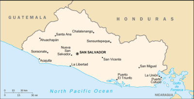
El Salvador or simply Salvador is the smallest and the most densely populated country in Central America. The country's capital city and largest city is San Salvador; Santa Ana and San Miguel are also important cultural and commercial centers in the country and in all of Central America...
is unique among the nations of Central America
Central America
Central America is the central geographic region of the Americas. It is the southernmost, isthmian portion of the North American continent, which connects with South America on the southeast. When considered part of the unified continental model, it is considered a subcontinent...
. The country borders the North Pacific Ocean
Pacific Ocean
The Pacific Ocean is the largest of the Earth's oceanic divisions. It extends from the Arctic in the north to the Southern Ocean in the south, bounded by Asia and Australia in the west, and the Americas in the east.At 165.2 million square kilometres in area, this largest division of the World...
to the south and southwest, with Guatemala
Guatemala
Guatemala is a country in Central America bordered by Mexico to the north and west, the Pacific Ocean to the southwest, Belize to the northeast, the Caribbean to the east, and Honduras and El Salvador to the southeast...
to the north-northwest and Honduras
Honduras
Honduras is a republic in Central America. It was previously known as Spanish Honduras to differentiate it from British Honduras, which became the modern-day state of Belize...
to the north-northeast. In the southeast, the Golfo de Fonseca separates it from Nicaragua
Nicaragua
Nicaragua is the largest country in the Central American American isthmus, bordered by Honduras to the north and Costa Rica to the south. The country is situated between 11 and 14 degrees north of the Equator in the Northern Hemisphere, which places it entirely within the tropics. The Pacific Ocean...
. El Salvador
El Salvador
El Salvador or simply Salvador is the smallest and the most densely populated country in Central America. The country's capital city and largest city is San Salvador; Santa Ana and San Miguel are also important cultural and commercial centers in the country and in all of Central America...
is the smallest Central American country in area and is the only one without a coast
Coast
A coastline or seashore is the area where land meets the sea or ocean. A precise line that can be called a coastline cannot be determined due to the dynamic nature of tides. The term "coastal zone" can be used instead, which is a spatial zone where interaction of the sea and land processes occurs...
line on the Caribbean sea
Caribbean Sea
The Caribbean Sea is a sea of the Atlantic Ocean located in the tropics of the Western hemisphere. It is bounded by Mexico and Central America to the west and southwest, to the north by the Greater Antilles, and to the east by the Lesser Antilles....
.
Geographic coordinates:
13°50′N 88°55′W
El Salvador, along with
WITH
WRBS is a radio station broadcasting a Christian talk format. Licensed to Baltimore, Maryland, the station serves the Baltimore area. The station is owned by WRBS-AM, LLC, a subsidiary of Peter and John Radio Fellowship, Inc...
the rest of Central America, is one of the most seismologically active regions on earth, situated atop three of the large tectonic
Tectonics
Tectonics is a field of study within geology concerned generally with the structures within the lithosphere of the Earth and particularly with the forces and movements that have operated in a region to create these structures.Tectonics is concerned with the orogenies and tectonic development of...
plates that constitute the Earth's surface. The motion of these plates causes the area's earthquake
Earthquake
An earthquake is the result of a sudden release of energy in the Earth's crust that creates seismic waves. The seismicity, seismism or seismic activity of an area refers to the frequency, type and size of earthquakes experienced over a period of time...
and volcanic
Volcano
2. Bedrock3. Conduit 4. Base5. Sill6. Dike7. Layers of ash emitted by the volcano8. Flank| 9. Layers of lava emitted by the volcano10. Throat11. Parasitic cone12. Lava flow13. Vent14. Crater15...
activity.
Most Central America and the Caribbean Basin
Caribbean Basin
The Caribbean Basin is generally defined as the area running from Florida westward along the Gulf coast, then south along the Mexican coast through Central America and then eastward across the northern coast of South America. This region includes the islands of the archipelago of the West Indies...
rests on the relatively motionless Caribbean Plate
Caribbean Plate
The Caribbean Plate is a mostly oceanic tectonic plate underlying Central America and the Caribbean Sea off the north coast of South America....
. The Pacific Ocean floor, however, is being carried northeast by the underlying motion of the Cocos Plate
Cocos Plate
The Cocos Plate is an oceanic tectonic plate beneath the Pacific Ocean off the west coast of Central America, named for Cocos Island, which rides upon it.-Geology:...
. Ocean floor material is largely composed of basalt
Basalt
Basalt is a common extrusive volcanic rock. It is usually grey to black and fine-grained due to rapid cooling of lava at the surface of a planet. It may be porphyritic containing larger crystals in a fine matrix, or vesicular, or frothy scoria. Unweathered basalt is black or grey...
, which is relatively dense; when it strikes the lighter granite
Granite
Granite is a common and widely occurring type of intrusive, felsic, igneous rock. Granite usually has a medium- to coarse-grained texture. Occasionally some individual crystals are larger than the groundmass, in which case the texture is known as porphyritic. A granitic rock with a porphyritic...
rocks of Central America, the ocean floor is forced down under the land mass, creating the deep Middle America Trench
Middle America Trench
The Middle America Trench is a major subduction zone, an oceanic trench in the eastern Pacific Ocean off the southwestern coast of Middle America, stretching from central Mexico to Costa Rica...
that lies off the coast of El Salvador. The subduction of the Cocos Plate accounts for the frequency of earthquakes near the coast. As the rocks constituting the ocean floor are forced down, they melt, and the molten material pours up through weaknesses in the surface rock, producing volcanoes and geyser
Geyser
A geyser is a spring characterized by intermittent discharge of water ejected turbulently and accompanied by a vapour phase . The word geyser comes from Geysir, the name of an erupting spring at Haukadalur, Iceland; that name, in turn, comes from the Icelandic verb geysa, "to gush", the verb...
s.
North of El Salvador, Mexico and most of Guatemala are riding on the westward-moving North American Plate
North American Plate
The North American Plate is a tectonic plate covering most of North America, Greenland, Cuba, Bahamas, and parts of Siberia, Japan and Iceland. It extends eastward to the Mid-Atlantic Ridge and westward to the Chersky Range in eastern Siberia. The plate includes both continental and oceanic crust...
that butts against the northern edge of the stationary Caribbean Plate
Caribbean Plate
The Caribbean Plate is a mostly oceanic tectonic plate underlying Central America and the Caribbean Sea off the north coast of South America....
in southern Guatemala. The grinding action of these two plates creates a fault, similar to the San Andreas fault
San Andreas
San Andreas is an archaic variation of the Spanish language San Andrés . It may refer to:*San Andreas Fault, a geologic fault that runs through California, USA...
in California, that runs the length of the valley of the Rio Motagua in Guatemala. Motion along this fault is the source of earthquakes in northernmost El Salvador.
El Salvador has a long history of destructive earthquakes and volcanic eruptions. San Salvador
San Salvador
The city of San Salvador the capital and largest city of El Salvador, which has been designated a Gamma World City. Its complete name is La Ciudad de Gran San Salvador...
was destroyed in 1756 and 1854, and it suffered heavy damage in the 1919, 1982, and 1986 tremors. The country has over twenty volcanoes, although only two, San Miguel and Izalco
Izalco (volcano)
Izalco is a stratovolcano on the side of the Santa Ana Volcano, which is located in western El Salvador. It is situated on the southern flank of the Santa Ana volcano. Izalco erupted almost continuously from 1770 to 1958 earning it the nickname of "Lighthouse of the Pacific", and experienced a...
, have been active in recent years. From the early nineteenth century to the mid 1950s, Izalco erupted with a regularity that earned it the name "Lighthouse of the Pacific." Its brilliant flares were clearly visible for great distances at sea, and at night its glowing lava turned it into a brilliant luminous cone.
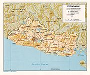
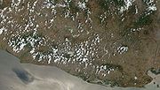
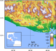
Physical features
Two parallel mountain ranges cross El Salvador to west with a central plateauPlateau
In geology and earth science, a plateau , also called a high plain or tableland, is an area of highland, usually consisting of relatively flat terrain. A highly eroded plateau is called a dissected plateau...
between them and a narrow coastal plain hugging the Pacific. These physical features divide the country into two physiographic regions. The mountain ranges and central plateau, covering 85 percent of the land, comprise the interior highlands. The remaining coastal plains are referred to as the Pacific lowlands.
The northern range of mountains, the Sierra Madre
Sierra Madre de Chiapas
Sierra Madre is a mountain range which runs northwest-southeast from the state of Chiapas in Mexico across Guatemala and into El Salvador and Honduras. Most of the volcanoes of Guatemala are a part of this range.A narrow coastal plain lies south the range, between the Sierra Madre and the Pacific...
, form a continuous chain along the border with Honduras. Elevations in this region range from 1,600 to 2,700 meters. The area was once heavily forested, but overexploitation
Overexploitation
Overexploitation, also called overharvesting, refers to harvesting a renewable resource to the point of diminishing returns. Sustained overexploitation can lead to the destruction of the resource...
led to extensive erosion, and it has become semibarren. As a result, it is the country's most sparsely populated zone, with little farming or other development.
The southern range of mountains is actually a discontinuous chain of more than twenty volcanoes, clustered into five groups. The westernmost group, near the Guatemalan border, contains Izalco
Izalco (volcano)
Izalco is a stratovolcano on the side of the Santa Ana Volcano, which is located in western El Salvador. It is situated on the southern flank of the Santa Ana volcano. Izalco erupted almost continuously from 1770 to 1958 earning it the nickname of "Lighthouse of the Pacific", and experienced a...
and Santa Ana, which at 2,365 meters is the highest volcano in El Salvador. Between the cones lie alluvial basins and rolling hills eroded from ash deposits. The volcanic soil is rich, and much of El Salvador's coffee
Coffee
Coffee is a brewed beverage with a dark,init brooo acidic flavor prepared from the roasted seeds of the coffee plant, colloquially called coffee beans. The beans are found in coffee cherries, which grow on trees cultivated in over 70 countries, primarily in equatorial Latin America, Southeast Asia,...
is planted on these slopes.
The central plateau constitutes only 25 percent of the land area but contains the heaviest concentration of population and the country's largest cities. This plain is about 50 kilometers wide and has an average elevation of 600 meters. Terrain here is rolling, with occasional escarpments, lava
Lava
Lava refers both to molten rock expelled by a volcano during an eruption and the resulting rock after solidification and cooling. This molten rock is formed in the interior of some planets, including Earth, and some of their satellites. When first erupted from a volcanic vent, lava is a liquid at...
fields, and geysers.
A narrow plain extends from the coastal volcanic range to the Pacific Ocean. This region has a width ranging from one to thirty-two kilometers with the widest section in the east, adjacent to the Golfo de Fonseca. Near La Libertad
La Libertad
La Libertad can refer to:;Ecuador*La Libertad, Guayas*La Libertad Canton;El Salvador*La Libertad, La Libertad*La Libertad Department;Honduras*La Libertad, Comayagua*La Libertad, Francisco Morazán;Guatemala*La Libertad, El Petén...
, however, the mountains pinch the lowlands out; the slopes of adjacent volcanoes come down directly to the ocean. Surfaces in the Pacific lowlands are generally flat or gently rolling and result from alluvial deposits from nearby slopes.
El Salvador has over 300 rivers, the most important of which is the Rio Lempa. Originating in Guatemala, the Rio Lempa cuts across the northern range of mountains, flows along much of the central plateau, and finally cuts through the southern volcanic range to empty into the Pacific. It is El Salvador's only navigable river, and it and its tributaries drain about half the country. Other rivers are generally short and drain the Pacific lowlands or flow from the central plateau through gaps in the southern mountain range to the Pacific.
Numerous lakes of volcanic origin are found in the interior highlands; many of these lakes are surrounded by mountains and have high, steep banks. The largest lake, the Lago de Ilopango, lies just to the east of the capital. Other large lakes include the Lago de Coatepeque
Coatepeque Caldera
Coatepeque Caldera also known as Lago De Coatepeque is a volcanic caldera in El Salvador in Central America. The caldera was formed during a series of major rhyolitic explosive eruptions between about 72,000 and 57,000 years ago...
in the west and the Lago de Güija
Lake Güija
Lake Güija is a lake in Central America. The lake is situated on the border between Guatemala and El Salvador and has an area of 45 km², of which approximately 32 km² lies in El Salvador....
on the Guatemalan border. The Cerron Grande Dam
Cerrón Grande Hydroelectric Dam
The Cerrón Grande Hydroelectric Dam spans the Lempa River 78 km north of San Salvador in the municipalities of Potonico, and Jutiapa in El Salvador....
on the Rio Lempa has created a large reservoir, the Embalse Cerron Grande, in northern El Salvador.
Izalco
Izalco (volcano)
Izalco is a stratovolcano on the side of the Santa Ana Volcano, which is located in western El Salvador. It is situated on the southern flank of the Santa Ana volcano. Izalco erupted almost continuously from 1770 to 1958 earning it the nickname of "Lighthouse of the Pacific", and experienced a...
has erupted at least 51 times since 1770. It earned the nickname "Lighthouse of the Pacific" because it was the most active volcano in Central America.
Climate
El Salvador has a tropical climate with pronounced wet and dry seasons. Temperatures vary primarily with elevation and show little seasonal change. The Pacific lowlands are uniformly hot; the central plateau and mountain areas are more moderate.The rainy season, known locally as invierno, or winter, extends from May to October. Almost all the annual rainfall occurs during this time, and yearly totals, particularly on southern-facing mountain slopes, can be as high as 2000 millimetres (78.7 in). Protected areas and the central plateau receive lesser, although still significant, amounts. Rainfall during this season generally comes from low pressure over the Pacific and usually falls in heavy afternoon thunderstorms. Although hurricanes occasionally form in the Pacific, they seldom affect El Salvador, with the notable exception of Hurricane Mitch
Hurricane Mitch
Hurricane Mitch was the most powerful hurricane and the most destructive of the 1998 Atlantic hurricane season, with maximum sustained winds of 180 mph . The storm was the thirteenth tropical storm, ninth hurricane, and third major hurricane of the season. Along with Hurricane Georges, Mitch...
and Hurricane Emily in 1998.
From November through April, the northeast trade wind
Trade wind
The trade winds are the prevailing pattern of easterly surface winds found in the tropics, within the lower portion of the Earth's atmosphere, in the lower section of the troposphere near the Earth's equator...
s control weather patterns. During these months, air flowing from the Caribbean has had most of the precipitation wrung out of it while passing over the mountains in Honduras. By the time this air reaches El Salvador, it is dry, hot, and hazy. This season is known locally as verano, or summer.
Temperatures vary little with season; elevation is the primary determinant. The Pacific lowlands are the hottest region, with annual averages ranging from 25 to 29 °C (77 to 84.2 °F). San Salvador is representative of the central plateau, with an annual average temperature of 23 °C (73.4 °F) and absolute high and low readings of 38 and 6 °C (100.4 and 42.8 °F), respectively. Mountain areas are the coolest, with annual averages from 12 to 23 °C (53.6 to 73.4 °F) and minimum temperatures sometimes approaching freezing.
Other facts
The total land area of El Salvador is 23,040 km², with 22,720 km² of land and 320 km² of water. This is slightly smaller than the U.S. stateU.S. state
A U.S. state is any one of the 50 federated states of the United States of America that share sovereignty with the federal government. Because of this shared sovereignty, an American is a citizen both of the federal entity and of his or her state of domicile. Four states use the official title of...
of Massachusetts
Massachusetts
The Commonwealth of Massachusetts is a state in the New England region of the northeastern United States of America. It is bordered by Rhode Island and Connecticut to the south, New York to the west, and Vermont and New Hampshire to the north; at its east lies the Atlantic Ocean. As of the 2010...
. El Salvador has 545 km of borders, including 342 km of borders with Honduras
Honduras
Honduras is a republic in Central America. It was previously known as Spanish Honduras to differentiate it from British Honduras, which became the modern-day state of Belize...
and 203 km with Guatemala
Guatemala
Guatemala is a country in Central America bordered by Mexico to the north and west, the Pacific Ocean to the southwest, Belize to the northeast, the Caribbean to the east, and Honduras and El Salvador to the southeast...
. El Salvador has a coastline of 307 km.
El Salvador claims a territorial sea of 200 nmi (370.4 km; 230.2 mi).
Climate:
tropical; rainy season (May to October); dry season (November to April); tropical on coast; temperate in uplands
Terrain:
mostly mountains with narrow coastal belt and central plateau
The lower point of elevation in El Salvador is the Pacific Ocean
Pacific Ocean
The Pacific Ocean is the largest of the Earth's oceanic divisions. It extends from the Arctic in the north to the Southern Ocean in the south, bounded by Asia and Australia in the west, and the Americas in the east.At 165.2 million square kilometres in area, this largest division of the World...
, at sea level
Sea level
Mean sea level is a measure of the average height of the ocean's surface ; used as a standard in reckoning land elevation...
. The highest point is Cerro El Pital
Cerro El Pital
Cerro El Pital is a mountain in Central America, on the border of El Salvador and Honduras. It is located from the town of La Palma and at a height of it is the highest point of the Salvadoran territory...
, at 2,730 m.
Natural resources:
hydropower
Hydropower
Hydropower, hydraulic power, hydrokinetic power or water power is power that is derived from the force or energy of falling water, which may be harnessed for useful purposes. Since ancient times, hydropower has been used for irrigation and the operation of various mechanical devices, such as...
, geothermal power
Geothermal power
Geothermal energy is thermal energy generated and stored in the Earth. Thermal energy is the energy that determines the temperature of matter. Earth's geothermal energy originates from the original formation of the planet and from radioactive decay of minerals...
, petroleum
Petroleum
Petroleum or crude oil is a naturally occurring, flammable liquid consisting of a complex mixture of hydrocarbons of various molecular weights and other liquid organic compounds, that are found in geologic formations beneath the Earth's surface. Petroleum is recovered mostly through oil drilling...
, arable land
Arable land
In geography and agriculture, arable land is land that can be used for growing crops. It includes all land under temporary crops , temporary meadows for mowing or pasture, land under market and kitchen gardens and land temporarily fallow...
Land use (1993 estimate) includes 29 percent permanent pasture, 27 percent arable land
Arable land
In geography and agriculture, arable land is land that can be used for growing crops. It includes all land under temporary crops , temporary meadows for mowing or pasture, land under market and kitchen gardens and land temporarily fallow...
, 8 percent permant crops, 5 percent forests and woodland, and 31 percent other.
Irrigated land:
1,200 km² (1993 est.)
Natural hazards:
El Salvador is known as the Land of Volcanoes; there are frequent and sometimes very destructive earthquakes and volcanic activity; catastophic hurricanes are uncommon.
Environment - current issues:
deforestation
Deforestation
Deforestation is the removal of a forest or stand of trees where the land is thereafter converted to a nonforest use. Examples of deforestation include conversion of forestland to farms, ranches, or urban use....
; soil erosion
Erosion
Erosion is when materials are removed from the surface and changed into something else. It only works by hydraulic actions and transport of solids in the natural environment, and leads to the deposition of these materials elsewhere...
; water pollution; contamination of soils from disposal of toxic waste
Toxic waste
Toxic waste is waste material that can cause death or injury to living creatures. It spreads quite easily and can contaminate lakes and rivers. The term is often used interchangeably with “hazardous waste”, or discarded material that can pose a long-term risk to health or environment.Toxic waste...
s; Hurricane Mitch
Hurricane Mitch
Hurricane Mitch was the most powerful hurricane and the most destructive of the 1998 Atlantic hurricane season, with maximum sustained winds of 180 mph . The storm was the thirteenth tropical storm, ninth hurricane, and third major hurricane of the season. Along with Hurricane Georges, Mitch...
damage
El Salvador is party to the Convention on Biological Diversity
Convention on Biological Diversity
The Convention on Biological Diversity , known informally as the Biodiversity Convention, is an international legally binding treaty...
, United Nations Framework Convention on Climate Change
United Nations Framework Convention on Climate Change
The United Nations Framework Convention on Climate Change is an international environmental treaty produced at the United Nations Conference on Environment and Development , informally known as the Earth Summit, held in Rio de Janeiro from June 3 to 14, 1992...
, Kyoto Protocol to the United Nations Framework Convention on Climate Change, United Nations Convention to Combat Desertification
United Nations Convention to Combat Desertification
The United Nations Convention to Combat Desertification in Those Countries Experiencing Serious Drought and/or Desertification, Particularly in Africa is a Convention to combat desertification and mitigate the effects of drought through national action programs that incorporate long-term strategies...
, CITES, Basel Convention
Basel Convention
The Basel Convention on the Control of Transboundary Movements of Hazardous Wastes and Their Disposal, usually known simply as the Basel Convention, is an international treaty that was designed to reduce the movements of hazardous waste between nations, and specifically to prevent transfer of...
, Partial Test Ban Treaty
Partial Test Ban Treaty
The treaty banning nuclear weapon tests in the atmosphere, in outer space and under water, often abbreviated as the Partial Test Ban Treaty , Limited Test Ban Treaty , or Nuclear Test Ban Treaty is a treaty prohibiting all test detonations of nuclear weapons...
, Montreal Protocol
Montreal Protocol
The Montreal Protocol on Substances That Deplete the Ozone Layer is an international treaty designed to protect the ozone layer by phasing out the production of numerous substances believed to be responsible for ozone depletion...
, Ramsar Convention
Ramsar Convention
The Ramsar Convention is an international treaty for the conservation and sustainable utilization of wetlands, i.e., to stem the progressive encroachment on and loss of wetlands now and in the future, recognizing the fundamental ecological functions of wetlands and their economic, cultural,...
. El Salvador has signed, but not ratified the United Nations Convention on the Law of the Sea
United Nations Convention on the Law of the Sea
The United Nations Convention on the Law of the Sea , also called the Law of the Sea Convention or the Law of the Sea treaty, is the international agreement that resulted from the third United Nations Conference on the Law of the Sea , which took place from 1973 through 1982...
.