

Geography of Egypt
Encyclopedia
The Geography of Egypt relates to two regions: Southwest Asia and North Africa.
Egypt
has coastlines on both the Mediterranean Sea
and the Red Sea
. The country borders Libya
to the west, the Gaza Strip
and Israel
to the east, and Sudan
to the south
. Covering 1,001,449 km2, Egypt has a land area about the same as that of Texas
and New Mexico
combined, four times bigger than that of the United Kingdom
, and twice as big as that of France
. The longest straight-line distance in Egypt from north to south is 1,024 km, while that from east to west measures 1,240 km. More than 2,900 km of coastline on the Mediterranean Sea
, the Gulf of Suez
, the Gulf of Aqaba
and the Red Sea
constitute Egypt's maritime boundaries
.
s (sometimes called province
s), which include four city governorates: Alexandria
(Al Iskandariyah
), Cairo
(Al Qahirah
), Port Said
(Bur Said) and Suez
. Also included are the nine governorates of Lower Egypt
in the Nile Delta
region, the eight governorates of Upper Egypt
along the Nile River south from Cairo to Aswan
, and the five frontier governorates covering Sinai and the deserts that lie west and east of the Nile. The Nile's fertile lands are great for farming purposes.
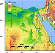 Egypt is predominantly desert
. Only 35,000 km2 - 3.5% - of the total land area is cultivated and permanently settled. Most of the country lies within the wide band of desert that stretches eastwards from Africa's Atlantic Coast
across the continent
and into southwest Asia.
Egypt's geological history has produced four major physical regions:
Despite covering only about 5.5% of the total area of Egypt, the Nile Valley and Nile Delta
are the most important regions, being the country's only cultivable regions and supporting about 99% of the population. The Nile valley extends approximately 800 km from Aswan to the outskirts of Cairo. The Nile Valley is also known as Upper Egypt
, while the Nile Delta region is known as Lower Egypt
. Steep rocky cliffs rise along the banks of the Nile in some stretches, while other areas along the Nile are flat, with space for agricultural production. In the past, flooding of the Nile during the summer provided silt and water to make agriculture possible on land that is otherwise very dry. Since construction of the Aswan Dam
, agriculture in the Nile valley depends on irrigation
. The Nile delta consists of flat, low-lying areas. Some parts of the delta are marshy and water-logged, and thus not suitable for agriculture. Other areas of the delta are used for agriculture.
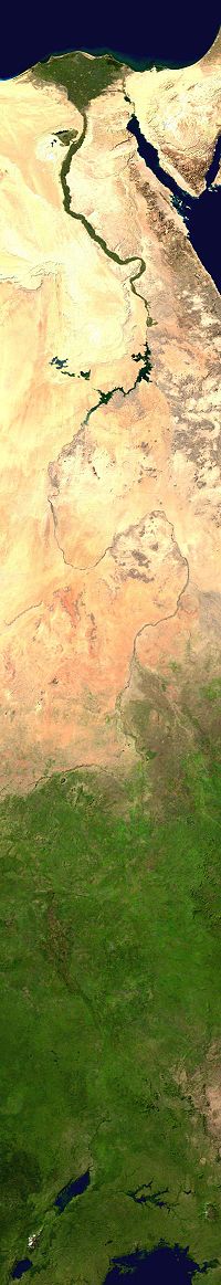
The Nile Valley and Delta, the most extensive oasis
on earth, was created by the world's longest river and its seemingly inexhaustible sources. Without the topographic channel
that permits the Nile to flow across the Sahara
, Egypt would be entirely desert. The length within Egypt of the River Nile in its northwards course from three central African sources – the White Nile
, the Blue Nile
, and the Atbara – totals some 1,600 km.
The White Nile, which begins at Lake Victoria
in Uganda
, supplies about 28% of the Nile's Egyptian waters. In its course from Lake Victoria to Juba
in southern Sudan, the White Nile's channel drops more than 600 m. In its 1,600-km course from Juba to Khartoum
, Sudan's capital, the river descends just 75 m. In southern and central Sudan, the White Nile passes through a wide, flat plain covered with swamp
vegetation
and slows almost to the point of stagnation
.
The Blue Nile, which originates at Lake Tana
in Ethiopia
, provides on average some 58% of the Nile's Egyptian waters. This river has a steeper gradient and therefore flows more swiftly than the White Nile, which it joins at Khartoum. Unlike the White Nile, the Blue Nile carries a considerable amount of sediment
. For several kilometres north of Khartoum, water closer to the eastern bank of the river, coming from the Blue Nile, is visibly mud
dy, while that closer to the western bank, and coming from the White Nile, is clearer.the blue river is part of the nile river with the white river.
The much shorter Atbara River, which also originates in Ethiopia, joins the main Nile north of Khartoum between the fifth and sixth cataracts
(areas of steep rapids) and provides about 14% of the Nile's waters in Egypt. During the low-water season, which runs from January to June, the Atbarah shrinks to a number of pools. But, in late-summer, when torrential rains fall on the Ethiopian plateau, the Atbarah provides 22% of the Nile's flow.
The Blue Nile has a similar pattern. It contributes 17% of the Nile's waters in the low-water season and 68% during the high-water season. In contrast, the White Nile provides only 10% of the Nile's waters during the high-water season but contributes more than 80% during the low-water period. Thus, before the Aswan High Dam was completed in 1971, the White Nile watered the Egyptian stretch of the river throughout the year, whereas the Blue Nile, carrying seasonal rain from Ethiopia, caused the Nile to overflow its banks and deposit a layer of fertile mud over adjacent fields. The great flood of the main Nile usually occurred in Egypt during August, September, and October, but it sometimes began as early as June at Aswan
and often did not completely wane until January.
The Nile enters Egypt a few kilometres north of Wadi Halfa
, a Sudanese town that was completely rebuilt on high ground when its original site was submerged in the reservoir
created by the Aswan High Dam. As a result of the dam's construction, the Nile actually begins its flow into Egypt as Lake Nasser
, which extends southwards from the dam for 320 km to the border and for an additional 158 km within Sudan. Lake Nasser's waters fill the area through Lower Nubia
(Upper Egypt and northern Sudan) within the narrow canyon
between the cliffs of sandstone
and granite
created by the flow of the river over many centuries. Below Aswan the cultivated floodplain
strip widens to as much as twenty km. North of Isna (160 km north of Aswan), the plateau on both sides of the valley rises to as much as 550 m above sea level; at Qina (some 90 km north of Isna) the 300-m limestone cliffs force the Nile to change course towards the southwest for about 60 km before it turna northwest for about 160 km to Asyut. Northward from Asyut, the escarpment
s on both sides diminish, and the valley widens to a maximum of 22 km.
At Cairo, the Nile spreads out over what was once a broad estuary
, subsequently filled by silt deposits to form what is now a fertile, fan-shaped delta
some 250 km wide at its seaward extremity and extending about 160 km from north to south. The Nile Delta covers approximately 22,000 km2 (roughly equivalent in area to that of Massachusetts
). According to historical accounts from the first century AD, seven branches of the Nile once ran through the delta. According to later accounts, the Nile had, by around the twelfth century, just six branches. Since then, nature and man have closed all but two main outlets: the east branch, Damietta
(also seen as Dumyat; 240 km long), and the west branch, Rosetta
(235 km long). Both outlets are named after the ports located at their respective mouths. A network of drainage
and irrigation
canals supplements these remaining outlets. In the north, near the coast, the Nile delta embraces a series of salt marshes and lakes, the most notable among which are Idku
, Al Burullus, and Manzilah.
The fertility and productivity of the land adjacent to the Nile depends largely on the silt
deposited by floodwaters. Archaeological research indicates that people once lived at a much higher elevation along the river than they do today, probably because the river was higher or the floods more severe. The timing and the amount of annual flow were always unpredictable. Measurements of annual flows as low as 1.2 billion m3 and as high as 4.25 billion m3 have been recorded. For centuries Egyptians attempted to predict and take advantage of these flows and thereby moderate the severity of floods.
The construction of dams
on the Nile, particularly the Aswan High Dam, transformed the mighty river into a large and predictable irrigation
ditch
. Lake Nasser, the world's largest artificial lake, has enabled planned use of the Nile regardless of the amount of rainfall in Central Africa
and East Africa
. The dams have also affected the Nile Valley's fertility
, which was dependent for centuries not only on the water brought to the arable land
but also on the materials left by the water. Researchers have estimated that beneficial silt deposits in the valley began about 10,000 years ago. The average annual deposit of arable soil through the course of the river valley amounted to some nine metres. Analysis of the flow revealed that 10.7 million tons of solid matter passed Cairo each year. Today the Aswan High Dam obstructs most of this sediment, now retained in Lake Nasser. The reduction in annual silt deposits has contributed to rising water tables and increasing soil salinity in the Delta, the erosion of the river's banks in Upper Egypt
, and the erosion of the alluvial fan
along the shore of the Mediterranean Sea.
), thereby accounting for around two-thirds of Egypt's total land area. This immense desert to the west of the Nile spans the area from the Mediterranean Sea southwards to the Sudanese border. The desert's Jilf al Kabir Plateau, at a mean altitude of some 1000 m, constitutes an exception to the uninterrupted territory of basement rocks covered by layers of horizontally bedded sediments forming a massive plain or low plateau. The Great Sand Sea lies within the desert's plain and extends from the Siwa Oasis
to Jilf al Kabir. Escarpment
s (ridges) and deep depressions (basins) exist in several parts of the Western Desert, and no rivers or streams drain into or out of the area.
The government has considered the Western Desert a frontier region and has divided it into two governorates at about the twenty-eighth parallel: Matruh
to the north and New Valley (Al Wadi al Jadid) to the south. There are seven important depressions in the Western Desert, and all are considered oases except the largest, Qattara, the water of which is salty. The Qattara Depression
, which includes the country's lowest point, encompasses approximately 15000 square kilometre, which is similar to the combined size of Connecticut
and Rhode Island
. It is largely below sea level and is 133 metres (436 ft) below sea level at the lowest. Badlands
, salt marshes, and salt lakes cover the sparsely inhabited Qattara Depression.
Limited agricultural production, the presence of some natural resources, and permanent settlements
are found in the other six depressions, all of which have fresh water provided by the Nile or by local groundwater
. The Siwah Oasis, close to the Libyan border and west of Qattara, is isolated from the rest of Egypt but has sustained life since ancient times. The Siwa's cliff-hung Temple of Amun was renowned for its oracles for more than 1,000 years. Herodotus
and Alexander the Great were among the many illustrious people who visited the temple in the pre-Christian era.
The other major oases form a topographic chain of basin
s extending from the Faiyum Oasis
(sometimes called the Fayyum Depression) which lies 60 kilometres (37 mi) southwest of Cairo
, south to the Bahariya, Farafirah, and Dakhilah oases before reaching the country's largest oasis, Kharijah. A brackish lake, Birket Qarun, at the northern reaches of Al Fayyum Oasis, drained into the Nile in ancient times. For centuries sweetwater artesian wells in the Fayyum Oasis have permitted extensive cultivation
in an irrigated area that extends over 1800 square kilometre.
 The topographic features of the region east of the Nile are very different from those of the Western Desert. The relatively mountainous Eastern Desert rises abruptly from the Nile and extends over an area of approximately 220,000 km2 (an area roughly equivalent to that covered by Utah
). The upward-sloping plateau
of sand
gives way within 100 km to arid, defoliated, rocky hills running north and south between the Sudan border and the Delta. The hills reach elevations of more than 1,900 m. The region's most prominent feature is the easterly chain of rugged mountains, the Red Sea Hills, which extend from the Nile Valley eastward to the Gulf of Suez
and the Red Sea. This elevated region has a natural drainage pattern that rarely functions because of insufficient rainfall. It also has a complex of irregular, sharply cut wadis that extend westward toward the Nile.
The Eastern Desert is generally isolated from the rest of the country. There is no oasis cultivation in the region because of the difficulty in sustaining any form of agriculture. Except for a few villages on the Red Sea
coast, there are no permanent settlements. The importance of the Eastern Desert lies in its natural resources, especially oil
. A single governorate, the capital of which is at Al Ghardaqah (or Hurgada), administers the entire region.
is a triangular-shaped peninsula
, about 61,100 km2 in area (slightly smaller than the U.S. state
of West Virginia
). Similar to the desert, the peninsula contains mountains in its southern sector that are a geological extension of the Red Sea Hills, the low range along the Red Sea coast that includes Mount Catherine
(Jabal Katrinah), the country's highest point, at 2,642 m above sea-level. The Red Sea may have been named after these mountains, which are red.
The southern side of the peninsula has a sharp escarpment that subsides after a narrow coastal shelf that slopes into the Red Sea and the Gulf of Aqaba
. The elevation of Sinai's southern rim is about 1,000 m. Moving northward, the elevation of this limestone
plateau decreases. The northern third of Sinai is a flat, sandy coastal plain, which extends from the Suez Canal into the Gaza Strip
and Israel
.
Before the Israeli military occupied Sinai during the June 1967 War (Arab-Israeli war, also known as the Six-Day War), a single Egyptian governorate administered the whole peninsula. By 1982 after all of Sinai was returned to Egypt, the central government divided the peninsula into two governorates. North Sinai has its capital at Al Arish and the South Sinai has its capital in Artt Turkishy.
from the Nile River.
, the points that are farther north, south, east or west than any other location.
Egypt
Egypt
Egypt , officially the Arab Republic of Egypt, Arabic: , is a country mainly in North Africa, with the Sinai Peninsula forming a land bridge in Southwest Asia. Egypt is thus a transcontinental country, and a major power in Africa, the Mediterranean Basin, the Middle East and the Muslim world...
has coastlines on both the Mediterranean Sea
Mediterranean Sea
The Mediterranean Sea is a sea connected to the Atlantic Ocean surrounded by the Mediterranean region and almost completely enclosed by land: on the north by Anatolia and Europe, on the south by North Africa, and on the east by the Levant...
and the Red Sea
Red Sea
The Red Sea is a seawater inlet of the Indian Ocean, lying between Africa and Asia. The connection to the ocean is in the south through the Bab el Mandeb strait and the Gulf of Aden. In the north, there is the Sinai Peninsula, the Gulf of Aqaba, and the Gulf of Suez...
. The country borders Libya
Libya
Libya is an African country in the Maghreb region of North Africa bordered by the Mediterranean Sea to the north, Egypt to the east, Sudan to the southeast, Chad and Niger to the south, and Algeria and Tunisia to the west....
to the west, the Gaza Strip
Gaza Strip
thumb|Gaza city skylineThe Gaza Strip lies on the Eastern coast of the Mediterranean Sea. The Strip borders Egypt on the southwest and Israel on the south, east and north. It is about long, and between 6 and 12 kilometres wide, with a total area of...
and Israel
Israel
The State of Israel is a parliamentary republic located in the Middle East, along the eastern shore of the Mediterranean Sea...
to the east, and Sudan
Sudan
Sudan , officially the Republic of the Sudan , is a country in North Africa, sometimes considered part of the Middle East politically. It is bordered by Egypt to the north, the Red Sea to the northeast, Eritrea and Ethiopia to the east, South Sudan to the south, the Central African Republic to the...
to the south
South
South is a noun, adjective, or adverb indicating direction or geography.South is one of the four cardinal directions or compass points. It is the opposite of north and is perpendicular to east and west.By convention, the bottom side of a map is south....
. Covering 1,001,449 km2, Egypt has a land area about the same as that of Texas
Texas
Texas is the second largest U.S. state by both area and population, and the largest state by area in the contiguous United States.The name, based on the Caddo word "Tejas" meaning "friends" or "allies", was applied by the Spanish to the Caddo themselves and to the region of their settlement in...
and New Mexico
New Mexico
New Mexico is a state located in the southwest and western regions of the United States. New Mexico is also usually considered one of the Mountain States. With a population density of 16 per square mile, New Mexico is the sixth-most sparsely inhabited U.S...
combined, four times bigger than that of the United Kingdom
United Kingdom
The United Kingdom of Great Britain and Northern IrelandIn the United Kingdom and Dependencies, other languages have been officially recognised as legitimate autochthonous languages under the European Charter for Regional or Minority Languages...
, and twice as big as that of France
France
The French Republic , The French Republic , The French Republic , (commonly known as France , is a unitary semi-presidential republic in Western Europe with several overseas territories and islands located on other continents and in the Indian, Pacific, and Atlantic oceans. Metropolitan France...
. The longest straight-line distance in Egypt from north to south is 1,024 km, while that from east to west measures 1,240 km. More than 2,900 km of coastline on the Mediterranean Sea
Mediterranean Sea
The Mediterranean Sea is a sea connected to the Atlantic Ocean surrounded by the Mediterranean region and almost completely enclosed by land: on the north by Anatolia and Europe, on the south by North Africa, and on the east by the Levant...
, the Gulf of Suez
Gulf of Suez
The northern end of the Red Sea is bifurcated by the Sinai Peninsula, creating the Gulf of Suez in the west and the Gulf of Aqaba to the east. The Gulf of Suez is formed within a relatively young, but now inactive rift basin, the Gulf of Suez Rift, dating back about 28 million years...
, the Gulf of Aqaba
Gulf of Aqaba
The Gulf of Aqaba is a large gulf located at the northern tip of the Red Sea. In pre twentieth-century and modern sources it is often named the Gulf of Eilat, as Eilat is its predominant Israeli city ....
and the Red Sea
Red Sea
The Red Sea is a seawater inlet of the Indian Ocean, lying between Africa and Asia. The connection to the ocean is in the south through the Bab el Mandeb strait and the Gulf of Aden. In the north, there is the Sinai Peninsula, the Gulf of Aqaba, and the Gulf of Suez...
constitute Egypt's maritime boundaries
Maritime boundary
Maritime boundary is a conceptual means of division of the water surface of the planet into maritime areas that are defined through surrounding physical geography or by human geography. As such it usually includes areas of exclusive national rights over the mineral and biological resources,...
.
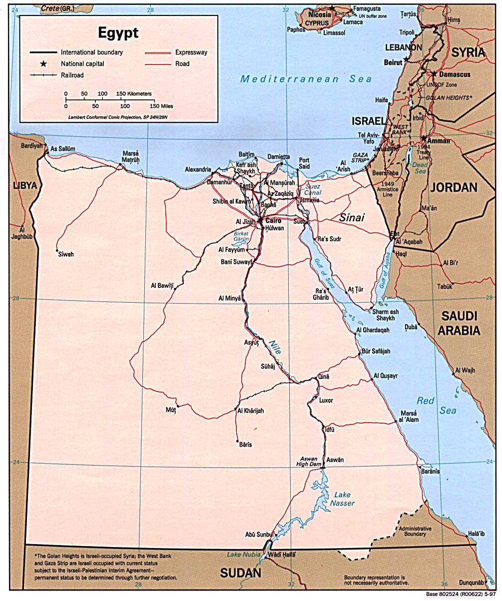
Governorates
Egypt is divided into twenty-six governorateGovernorate
A governorate is an administrative division of a country. It is headed by a governor. As English-speaking nations tend to call regions administered by governors either states, provinces, or colonies, the term governorate is often used in translation from non-English-speaking administrations.The...
s (sometimes called province
Province
A province is a territorial unit, almost always an administrative division, within a country or state.-Etymology:The English word "province" is attested since about 1330 and derives from the 13th-century Old French "province," which itself comes from the Latin word "provincia," which referred to...
s), which include four city governorates: Alexandria
Alexandria
Alexandria is the second-largest city of Egypt, with a population of 4.1 million, extending about along the coast of the Mediterranean Sea in the north central part of the country; it is also the largest city lying directly on the Mediterranean coast. It is Egypt's largest seaport, serving...
(Al Iskandariyah
Al Iskandariyah Governorate
Alexandria Governorate is one of the governorates of Egypt. It is located in the northern part of the country, directly on the Mediterranean Sea, making it one of the most important harbours in Egypt.-Overview:...
), Cairo
Cairo
Cairo , is the capital of Egypt and the largest city in the Arab world and Africa, and the 16th largest metropolitan area in the world. Nicknamed "The City of a Thousand Minarets" for its preponderance of Islamic architecture, Cairo has long been a centre of the region's political and cultural life...
(Al Qahirah
Al Qahirah Governorate
Cairo Governorate is the most populated of the governorates of Egypt. Its capital is the national capital of Cairo. Because it is completely urbanized, the governorate is considered a city proper, and functions as a municipality....
), Port Said
Port Said
Port Said is a city that lies in north east Egypt extending about 30 km along the coast of the Mediterranean Sea, north of the Suez Canal, with an approximate population of 603,787...
(Bur Said) and Suez
Suez
Suez is a seaport city in north-eastern Egypt, located on the north coast of the Gulf of Suez , near the southern terminus of the Suez Canal, having the same boundaries as Suez governorate. It has three harbors, Adabya, Ain Sokhna and Port Tawfiq, and extensive port facilities...
. Also included are the nine governorates of Lower Egypt
Lower Egypt
Lower Egypt is the northern-most section of Egypt. It refers to the fertile Nile Delta region, which stretches from the area between El-Aiyat and Zawyet Dahshur, south of modern-day Cairo, and the Mediterranean Sea....
in the Nile Delta
Nile Delta
The Nile Delta is the delta formed in Northern Egypt where the Nile River spreads out and drains into the Mediterranean Sea. It is one of the world's largest river deltas—from Alexandria in the west to Port Said in the east, it covers some 240 km of Mediterranean coastline—and is a rich...
region, the eight governorates of Upper Egypt
Upper Egypt
Upper Egypt is the strip of land, on both sides of the Nile valley, that extends from the cataract boundaries of modern-day Aswan north to the area between El-Ayait and Zawyet Dahshur . The northern section of Upper Egypt, between El-Ayait and Sohag is sometimes known as Middle Egypt...
along the Nile River south from Cairo to Aswan
Aswan
Aswan , formerly spelled Assuan, is a city in the south of Egypt, the capital of the Aswan Governorate.It stands on the east bank of the Nile at the first cataract and is a busy market and tourist centre...
, and the five frontier governorates covering Sinai and the deserts that lie west and east of the Nile. The Nile's fertile lands are great for farming purposes.
Natural regions
Desert
A desert is a landscape or region that receives an extremely low amount of precipitation, less than enough to support growth of most plants. Most deserts have an average annual precipitation of less than...
. Only 35,000 km2 - 3.5% - of the total land area is cultivated and permanently settled. Most of the country lies within the wide band of desert that stretches eastwards from Africa's Atlantic Coast
Atlantic Ocean
The Atlantic Ocean is the second-largest of the world's oceanic divisions. With a total area of about , it covers approximately 20% of the Earth's surface and about 26% of its water surface area...
across the continent
Continent
A continent is one of several very large landmasses on Earth. They are generally identified by convention rather than any strict criteria, with seven regions commonly regarded as continents—they are : Asia, Africa, North America, South America, Antarctica, Europe, and Australia.Plate tectonics is...
and into southwest Asia.
Egypt's geological history has produced four major physical regions:
- NileNileThe Nile is a major north-flowing river in North Africa, generally regarded as the longest river in the world. It is long. It runs through the ten countries of Sudan, South Sudan, Burundi, Rwanda, Democratic Republic of the Congo, Tanzania, Kenya, Ethiopia, Uganda and Egypt.The Nile has two major...
Valley and Nile DeltaNile DeltaThe Nile Delta is the delta formed in Northern Egypt where the Nile River spreads out and drains into the Mediterranean Sea. It is one of the world's largest river deltas—from Alexandria in the west to Port Said in the east, it covers some 240 km of Mediterranean coastline—and is a rich... - Western Desert (also known as the Libyan DesertLibyan DesertThe Libyan Desert covers an area of approximately 1,100,000 km2, it extends approximately 1100 km from east to west, and 1,000 km from north to south, in about the shape of a rectangle...
) - Eastern DesertEastern DesertThe Eastern Desert is the section of Sahara Desert east of the Nile River, between the river and the Red Sea. It extends from Egypt in the north to Eritrea in the south, and also comprises parts of Sudan and Ethiopia.-Features:...
(also known as the Arabian Desert) - Sinai PeninsulaSinai PeninsulaThe Sinai Peninsula or Sinai is a triangular peninsula in Egypt about in area. It is situated between the Mediterranean Sea to the north, and the Red Sea to the south, and is the only part of Egyptian territory located in Asia as opposed to Africa, effectively serving as a land bridge between two...
Despite covering only about 5.5% of the total area of Egypt, the Nile Valley and Nile Delta
Nile Delta
The Nile Delta is the delta formed in Northern Egypt where the Nile River spreads out and drains into the Mediterranean Sea. It is one of the world's largest river deltas—from Alexandria in the west to Port Said in the east, it covers some 240 km of Mediterranean coastline—and is a rich...
are the most important regions, being the country's only cultivable regions and supporting about 99% of the population. The Nile valley extends approximately 800 km from Aswan to the outskirts of Cairo. The Nile Valley is also known as Upper Egypt
Upper Egypt
Upper Egypt is the strip of land, on both sides of the Nile valley, that extends from the cataract boundaries of modern-day Aswan north to the area between El-Ayait and Zawyet Dahshur . The northern section of Upper Egypt, between El-Ayait and Sohag is sometimes known as Middle Egypt...
, while the Nile Delta region is known as Lower Egypt
Lower Egypt
Lower Egypt is the northern-most section of Egypt. It refers to the fertile Nile Delta region, which stretches from the area between El-Aiyat and Zawyet Dahshur, south of modern-day Cairo, and the Mediterranean Sea....
. Steep rocky cliffs rise along the banks of the Nile in some stretches, while other areas along the Nile are flat, with space for agricultural production. In the past, flooding of the Nile during the summer provided silt and water to make agriculture possible on land that is otherwise very dry. Since construction of the Aswan Dam
Aswan Dam
The Aswan Dam is an embankment dam situated across the Nile River in Aswan, Egypt. Since the 1950s, the name commonly refers to the High Dam, which is larger and newer than the Aswan Low Dam, which was first completed in 1902...
, agriculture in the Nile valley depends on irrigation
Irrigation
Irrigation may be defined as the science of artificial application of water to the land or soil. It is used to assist in the growing of agricultural crops, maintenance of landscapes, and revegetation of disturbed soils in dry areas and during periods of inadequate rainfall...
. The Nile delta consists of flat, low-lying areas. Some parts of the delta are marshy and water-logged, and thus not suitable for agriculture. Other areas of the delta are used for agriculture.
Nile Valley and Delta
The Nile Valley and Delta, the most extensive oasis
Oasis
In geography, an oasis or cienega is an isolated area of vegetation in a desert, typically surrounding a spring or similar water source...
on earth, was created by the world's longest river and its seemingly inexhaustible sources. Without the topographic channel
Stream channel
Stream channel is the physical confine of a stream consisting of a bed and stream banks.Stream channels exist in a variety of geometries. The stream channel development is controlled by both water and sediment movement. There is a difference between low gradient streams and high gradient streams...
that permits the Nile to flow across the Sahara
Sahara
The Sahara is the world's second largest desert, after Antarctica. At over , it covers most of Northern Africa, making it almost as large as Europe or the United States. The Sahara stretches from the Red Sea, including parts of the Mediterranean coasts, to the outskirts of the Atlantic Ocean...
, Egypt would be entirely desert. The length within Egypt of the River Nile in its northwards course from three central African sources – the White Nile
White Nile
The White Nile is a river of Africa, one of the two main tributaries of the Nile from Egypt, the other being the Blue Nile. In the strict meaning, "White Nile" refers to the river formed at Lake No at the confluence of the Bahr al Jabal and Bahr el Ghazal rivers...
, the Blue Nile
Blue Nile
The Blue Nile is a river originating at Lake Tana in Ethiopia. With the White Nile, the river is one of the two major tributaries of the Nile...
, and the Atbara – totals some 1,600 km.
The White Nile, which begins at Lake Victoria
Lake Victoria
Lake Victoria is one of the African Great Lakes. The lake was named for Queen Victoria of the United Kingdom, by John Hanning Speke, the first European to discover this lake....
in Uganda
Uganda
Uganda , officially the Republic of Uganda, is a landlocked country in East Africa. Uganda is also known as the "Pearl of Africa". It is bordered on the east by Kenya, on the north by South Sudan, on the west by the Democratic Republic of the Congo, on the southwest by Rwanda, and on the south by...
, supplies about 28% of the Nile's Egyptian waters. In its course from Lake Victoria to Juba
Juba, Sudan
Juba is the capital and largest city of the Republic of South Sudan. It also serves as the capital of Central Equatoria, the smallest of the ten states of South Sudan. The city is situated on the White Nile and functions as the seat and metropolis of Juba County.- Population :In 2005, Juba's...
in southern Sudan, the White Nile's channel drops more than 600 m. In its 1,600-km course from Juba to Khartoum
Khartoum
Khartoum is the capital and largest city of Sudan and of Khartoum State. It is located at the confluence of the White Nile flowing north from Lake Victoria, and the Blue Nile flowing west from Ethiopia. The location where the two Niles meet is known as "al-Mogran"...
, Sudan's capital, the river descends just 75 m. In southern and central Sudan, the White Nile passes through a wide, flat plain covered with swamp
Swamp
A swamp is a wetland with some flooding of large areas of land by shallow bodies of water. A swamp generally has a large number of hammocks, or dry-land protrusions, covered by aquatic vegetation, or vegetation that tolerates periodical inundation. The two main types of swamp are "true" or swamp...
vegetation
Vegetation
Vegetation is a general term for the plant life of a region; it refers to the ground cover provided by plants. It is a general term, without specific reference to particular taxa, life forms, structure, spatial extent, or any other specific botanical or geographic characteristics. It is broader...
and slows almost to the point of stagnation
Water stagnation
Water stagnation occurs when water stops flowing. Stagnant water can be a major environmental hazard.-Dangers:Malaria and dengue are among the main dangers of stagnant water, which can become a breeding ground for the mosquitoes that transmit these diseases.Stagnant or Stailment water can be...
.
The Blue Nile, which originates at Lake Tana
Lake Tana
Lake Tana is the source of the Blue Nile and is the largest lake in Ethiopia...
in Ethiopia
Ethiopia
Ethiopia , officially known as the Federal Democratic Republic of Ethiopia, is a country located in the Horn of Africa. It is the second-most populous nation in Africa, with over 82 million inhabitants, and the tenth-largest by area, occupying 1,100,000 km2...
, provides on average some 58% of the Nile's Egyptian waters. This river has a steeper gradient and therefore flows more swiftly than the White Nile, which it joins at Khartoum. Unlike the White Nile, the Blue Nile carries a considerable amount of sediment
Sediment
Sediment is naturally occurring material that is broken down by processes of weathering and erosion, and is subsequently transported by the action of fluids such as wind, water, or ice, and/or by the force of gravity acting on the particle itself....
. For several kilometres north of Khartoum, water closer to the eastern bank of the river, coming from the Blue Nile, is visibly mud
Mud
Mud is a mixture of water and some combination of soil, silt, and clay. Ancient mud deposits harden over geological time to form sedimentary rock such as shale or mudstone . When geological deposits of mud are formed in estuaries the resultant layers are termed bay muds...
dy, while that closer to the western bank, and coming from the White Nile, is clearer.the blue river is part of the nile river with the white river.
The much shorter Atbara River, which also originates in Ethiopia, joins the main Nile north of Khartoum between the fifth and sixth cataracts
Waterfall
A waterfall is a place where flowing water rapidly drops in elevation as it flows over a steep region or a cliff.-Formation:Waterfalls are commonly formed when a river is young. At these times the channel is often narrow and deep. When the river courses over resistant bedrock, erosion happens...
(areas of steep rapids) and provides about 14% of the Nile's waters in Egypt. During the low-water season, which runs from January to June, the Atbarah shrinks to a number of pools. But, in late-summer, when torrential rains fall on the Ethiopian plateau, the Atbarah provides 22% of the Nile's flow.
The Blue Nile has a similar pattern. It contributes 17% of the Nile's waters in the low-water season and 68% during the high-water season. In contrast, the White Nile provides only 10% of the Nile's waters during the high-water season but contributes more than 80% during the low-water period. Thus, before the Aswan High Dam was completed in 1971, the White Nile watered the Egyptian stretch of the river throughout the year, whereas the Blue Nile, carrying seasonal rain from Ethiopia, caused the Nile to overflow its banks and deposit a layer of fertile mud over adjacent fields. The great flood of the main Nile usually occurred in Egypt during August, September, and October, but it sometimes began as early as June at Aswan
Aswan
Aswan , formerly spelled Assuan, is a city in the south of Egypt, the capital of the Aswan Governorate.It stands on the east bank of the Nile at the first cataract and is a busy market and tourist centre...
and often did not completely wane until January.
The Nile enters Egypt a few kilometres north of Wadi Halfa
Wadi Halfa
Wadi Halfa is a city in the state of Northern, in northern Sudan, on the shores of Lake Nubia . It is the terminus of a rail line from Khartoum and the point where goods are transferred from rail to ferries going down the Lake Nasser...
, a Sudanese town that was completely rebuilt on high ground when its original site was submerged in the reservoir
Reservoir
A reservoir , artificial lake or dam is used to store water.Reservoirs may be created in river valleys by the construction of a dam or may be built by excavation in the ground or by conventional construction techniques such as brickwork or cast concrete.The term reservoir may also be used to...
created by the Aswan High Dam. As a result of the dam's construction, the Nile actually begins its flow into Egypt as Lake Nasser
Lake Nasser
Lake Nasser is a vast reservoir in southern Egypt, and northern Sudan, and is one of the largest man-made lakes in the world. Strictly, "Lake Nasser" refers only to the much larger portion of the lake that is in Egyptian territory , with the Sudanese preferring to call their smaller body of water...
, which extends southwards from the dam for 320 km to the border and for an additional 158 km within Sudan. Lake Nasser's waters fill the area through Lower Nubia
Lower Nubia
Lower Nubia is the northern portion of Nubia, downstream on the Nile from Upper Nubia. It lies between the First and Second Cataracts, roughly from Aswan in the north to Wadi Halfa in the south. A great deal of Lower Nubia was flooded with the construction of the Aswan High Dam and the creation...
(Upper Egypt and northern Sudan) within the narrow canyon
Canyon
A canyon or gorge is a deep ravine between cliffs often carved from the landscape by a river. Rivers have a natural tendency to reach a baseline elevation, which is the same elevation as the body of water it will eventually drain into. This forms a canyon. Most canyons were formed by a process of...
between the cliffs of sandstone
Sandstone
Sandstone is a sedimentary rock composed mainly of sand-sized minerals or rock grains.Most sandstone is composed of quartz and/or feldspar because these are the most common minerals in the Earth's crust. Like sand, sandstone may be any colour, but the most common colours are tan, brown, yellow,...
and granite
Granite
Granite is a common and widely occurring type of intrusive, felsic, igneous rock. Granite usually has a medium- to coarse-grained texture. Occasionally some individual crystals are larger than the groundmass, in which case the texture is known as porphyritic. A granitic rock with a porphyritic...
created by the flow of the river over many centuries. Below Aswan the cultivated floodplain
Floodplain
A floodplain, or flood plain, is a flat or nearly flat land adjacent a stream or river that stretches from the banks of its channel to the base of the enclosing valley walls and experiences flooding during periods of high discharge...
strip widens to as much as twenty km. North of Isna (160 km north of Aswan), the plateau on both sides of the valley rises to as much as 550 m above sea level; at Qina (some 90 km north of Isna) the 300-m limestone cliffs force the Nile to change course towards the southwest for about 60 km before it turna northwest for about 160 km to Asyut. Northward from Asyut, the escarpment
Escarpment
An escarpment is a steep slope or long cliff that occurs from erosion or faulting and separates two relatively level areas of differing elevations.-Description and variants:...
s on both sides diminish, and the valley widens to a maximum of 22 km.
At Cairo, the Nile spreads out over what was once a broad estuary
Estuary
An estuary is a partly enclosed coastal body of water with one or more rivers or streams flowing into it, and with a free connection to the open sea....
, subsequently filled by silt deposits to form what is now a fertile, fan-shaped delta
River delta
A delta is a landform that is formed at the mouth of a river where that river flows into an ocean, sea, estuary, lake, reservoir, flat arid area, or another river. Deltas are formed from the deposition of the sediment carried by the river as the flow leaves the mouth of the river...
some 250 km wide at its seaward extremity and extending about 160 km from north to south. The Nile Delta covers approximately 22,000 km2 (roughly equivalent in area to that of Massachusetts
Massachusetts
The Commonwealth of Massachusetts is a state in the New England region of the northeastern United States of America. It is bordered by Rhode Island and Connecticut to the south, New York to the west, and Vermont and New Hampshire to the north; at its east lies the Atlantic Ocean. As of the 2010...
). According to historical accounts from the first century AD, seven branches of the Nile once ran through the delta. According to later accounts, the Nile had, by around the twelfth century, just six branches. Since then, nature and man have closed all but two main outlets: the east branch, Damietta
Damietta
Damietta , also known as Damiata, or Domyat, is a port and the capital of the Damietta Governorate in Egypt. It is located at the intersection between the Mediterranean Sea and the Nile, about north of Cairo.-History:...
(also seen as Dumyat; 240 km long), and the west branch, Rosetta
Rosetta
Rosetta is a port city on the Mediterranean coast of Egypt. It is located east of Alexandria, in Beheira governorate. It was founded around AD 800....
(235 km long). Both outlets are named after the ports located at their respective mouths. A network of drainage
Drainage
Drainage is the natural or artificial removal of surface and sub-surface water from an area. Many agricultural soils need drainage to improve production or to manage water supplies.-Early history:...
and irrigation
Irrigation
Irrigation may be defined as the science of artificial application of water to the land or soil. It is used to assist in the growing of agricultural crops, maintenance of landscapes, and revegetation of disturbed soils in dry areas and during periods of inadequate rainfall...
canals supplements these remaining outlets. In the north, near the coast, the Nile delta embraces a series of salt marshes and lakes, the most notable among which are Idku
Idku
Idku, also spelt Edkou is a town in Al Buhayrah Governorate, Egypt....
, Al Burullus, and Manzilah.
The fertility and productivity of the land adjacent to the Nile depends largely on the silt
Silt
Silt is granular material of a size somewhere between sand and clay whose mineral origin is quartz and feldspar. Silt may occur as a soil or as suspended sediment in a surface water body...
deposited by floodwaters. Archaeological research indicates that people once lived at a much higher elevation along the river than they do today, probably because the river was higher or the floods more severe. The timing and the amount of annual flow were always unpredictable. Measurements of annual flows as low as 1.2 billion m3 and as high as 4.25 billion m3 have been recorded. For centuries Egyptians attempted to predict and take advantage of these flows and thereby moderate the severity of floods.
The construction of dams
DAMS
Driot-Arnoux Motorsport is a racing team from France, involved in many areas of motorsports. DAMS was founded in 1988 by Jean-Paul Driot and former Formula One driver René Arnoux. It is headquartered near Le Mans, only 2 km from the Bugatti Circuit.- History :The year after its foundation,...
on the Nile, particularly the Aswan High Dam, transformed the mighty river into a large and predictable irrigation
Irrigation
Irrigation may be defined as the science of artificial application of water to the land or soil. It is used to assist in the growing of agricultural crops, maintenance of landscapes, and revegetation of disturbed soils in dry areas and during periods of inadequate rainfall...
ditch
Ditch
A ditch is usually defined as a small to moderate depression created to channel water.In Anglo-Saxon, the word dïc already existed and was pronounced 'deek' in northern England and 'deetch' in the south. The origins of the word lie in digging a trench and forming the upcast soil into a bank...
. Lake Nasser, the world's largest artificial lake, has enabled planned use of the Nile regardless of the amount of rainfall in Central Africa
Central Africa
Central Africa is a core region of the African continent which includes Burundi, the Central African Republic, Chad, the Democratic Republic of the Congo, and Rwanda....
and East Africa
East Africa
East Africa or Eastern Africa is the easterly region of the African continent, variably defined by geography or geopolitics. In the UN scheme of geographic regions, 19 territories constitute Eastern Africa:...
. The dams have also affected the Nile Valley's fertility
Fertility
Fertility is the natural capability of producing offsprings. As a measure, "fertility rate" is the number of children born per couple, person or population. Fertility differs from fecundity, which is defined as the potential for reproduction...
, which was dependent for centuries not only on the water brought to the arable land
Arable land
In geography and agriculture, arable land is land that can be used for growing crops. It includes all land under temporary crops , temporary meadows for mowing or pasture, land under market and kitchen gardens and land temporarily fallow...
but also on the materials left by the water. Researchers have estimated that beneficial silt deposits in the valley began about 10,000 years ago. The average annual deposit of arable soil through the course of the river valley amounted to some nine metres. Analysis of the flow revealed that 10.7 million tons of solid matter passed Cairo each year. Today the Aswan High Dam obstructs most of this sediment, now retained in Lake Nasser. The reduction in annual silt deposits has contributed to rising water tables and increasing soil salinity in the Delta, the erosion of the river's banks in Upper Egypt
Upper Egypt
Upper Egypt is the strip of land, on both sides of the Nile valley, that extends from the cataract boundaries of modern-day Aswan north to the area between El-Ayait and Zawyet Dahshur . The northern section of Upper Egypt, between El-Ayait and Sohag is sometimes known as Middle Egypt...
, and the erosion of the alluvial fan
Alluvial fan
An alluvial fan is a fan-shaped deposit formed where a fast flowing stream flattens, slows, and spreads typically at the exit of a canyon onto a flatter plain. A convergence of neighboring alluvial fans into a single apron of deposits against a slope is called a bajada, or compound alluvial...
along the shore of the Mediterranean Sea.
Western Desert
The Western Desert covers an area of some 700,000 km2 (a little larger than that of TexasTexas
Texas is the second largest U.S. state by both area and population, and the largest state by area in the contiguous United States.The name, based on the Caddo word "Tejas" meaning "friends" or "allies", was applied by the Spanish to the Caddo themselves and to the region of their settlement in...
), thereby accounting for around two-thirds of Egypt's total land area. This immense desert to the west of the Nile spans the area from the Mediterranean Sea southwards to the Sudanese border. The desert's Jilf al Kabir Plateau, at a mean altitude of some 1000 m, constitutes an exception to the uninterrupted territory of basement rocks covered by layers of horizontally bedded sediments forming a massive plain or low plateau. The Great Sand Sea lies within the desert's plain and extends from the Siwa Oasis
Siwa Oasis
The Siwa Oasis is an oasis in Egypt, located between the Qattara Depression and the Egyptian Sand Sea in the Libyan Desert, nearly 50 km east of the Libyan border, and 560 km from Cairo....
to Jilf al Kabir. Escarpment
Escarpment
An escarpment is a steep slope or long cliff that occurs from erosion or faulting and separates two relatively level areas of differing elevations.-Description and variants:...
s (ridges) and deep depressions (basins) exist in several parts of the Western Desert, and no rivers or streams drain into or out of the area.
The government has considered the Western Desert a frontier region and has divided it into two governorates at about the twenty-eighth parallel: Matruh
Matruh
Matrouh Governorate is one of the governorates of Egypt. Located in the north-western part of the country, it borders Libya. Its capital is Marsa Matrouh.-Overview:...
to the north and New Valley (Al Wadi al Jadid) to the south. There are seven important depressions in the Western Desert, and all are considered oases except the largest, Qattara, the water of which is salty. The Qattara Depression
Qattara Depression
The Qattara Depression is a depression in the north west of Egypt in the Matruh Governorate and is part of the Libyan Desert. It lies below sea level and is covered with salt pans, sand dunes and salt marshes. The region extends between latitudes of 28°35' and 30°25' North and longitudes of 26°20'...
, which includes the country's lowest point, encompasses approximately 15000 square kilometre, which is similar to the combined size of Connecticut
Connecticut
Connecticut is a state in the New England region of the northeastern United States. It is bordered by Rhode Island to the east, Massachusetts to the north, and the state of New York to the west and the south .Connecticut is named for the Connecticut River, the major U.S. river that approximately...
and Rhode Island
Rhode Island
The state of Rhode Island and Providence Plantations, more commonly referred to as Rhode Island , is a state in the New England region of the United States. It is the smallest U.S. state by area...
. It is largely below sea level and is 133 metres (436 ft) below sea level at the lowest. Badlands
Badlands
A badlands is a type of dry terrain where softer sedimentary rocks and clay-rich soils have been extensively eroded by wind and water. It can resemble malpaís, a terrain of volcanic rock. Canyons, ravines, gullies, hoodoos and other such geological forms are common in badlands. They are often...
, salt marshes, and salt lakes cover the sparsely inhabited Qattara Depression.
Limited agricultural production, the presence of some natural resources, and permanent settlements
Community
The term community has two distinct meanings:*a group of interacting people, possibly living in close proximity, and often refers to a group that shares some common values, and is attributed with social cohesion within a shared geographical location, generally in social units larger than a household...
are found in the other six depressions, all of which have fresh water provided by the Nile or by local groundwater
Groundwater
Groundwater is water located beneath the ground surface in soil pore spaces and in the fractures of rock formations. A unit of rock or an unconsolidated deposit is called an aquifer when it can yield a usable quantity of water. The depth at which soil pore spaces or fractures and voids in rock...
. The Siwah Oasis, close to the Libyan border and west of Qattara, is isolated from the rest of Egypt but has sustained life since ancient times. The Siwa's cliff-hung Temple of Amun was renowned for its oracles for more than 1,000 years. Herodotus
Herodotus
Herodotus was an ancient Greek historian who was born in Halicarnassus, Caria and lived in the 5th century BC . He has been called the "Father of History", and was the first historian known to collect his materials systematically, test their accuracy to a certain extent and arrange them in a...
and Alexander the Great were among the many illustrious people who visited the temple in the pre-Christian era.
The other major oases form a topographic chain of basin
Depression (geology)
A depression in geology is a landform sunken or depressed below the surrounding area. Depressions may be formed by various mechanisms.Structural or tectonic related:...
s extending from the Faiyum Oasis
Faiyum Oasis
The Faiyum Oasis is a depression or basin in the desert immediately to the west of the Nile south of Cairo. The extent of the basin area is estimated at between 490 mi² and 656 mi²...
(sometimes called the Fayyum Depression) which lies 60 kilometres (37 mi) southwest of Cairo
Cairo
Cairo , is the capital of Egypt and the largest city in the Arab world and Africa, and the 16th largest metropolitan area in the world. Nicknamed "The City of a Thousand Minarets" for its preponderance of Islamic architecture, Cairo has long been a centre of the region's political and cultural life...
, south to the Bahariya, Farafirah, and Dakhilah oases before reaching the country's largest oasis, Kharijah. A brackish lake, Birket Qarun, at the northern reaches of Al Fayyum Oasis, drained into the Nile in ancient times. For centuries sweetwater artesian wells in the Fayyum Oasis have permitted extensive cultivation
Tillage
Tillage is the agricultural preparation of the soil by mechanical agitation of various types, such as digging, stirring, and overturning. Examples of human-powered tilling methods using hand tools include shovelling, picking, mattock work, hoeing, and raking...
in an irrigated area that extends over 1800 square kilometre.
Eastern Desert
Utah
Utah is a state in the Western United States. It was the 45th state to join the Union, on January 4, 1896. Approximately 80% of Utah's 2,763,885 people live along the Wasatch Front, centering on Salt Lake City. This leaves vast expanses of the state nearly uninhabited, making the population the...
). The upward-sloping plateau
Plateau
In geology and earth science, a plateau , also called a high plain or tableland, is an area of highland, usually consisting of relatively flat terrain. A highly eroded plateau is called a dissected plateau...
of sand
Sand
Sand is a naturally occurring granular material composed of finely divided rock and mineral particles.The composition of sand is highly variable, depending on the local rock sources and conditions, but the most common constituent of sand in inland continental settings and non-tropical coastal...
gives way within 100 km to arid, defoliated, rocky hills running north and south between the Sudan border and the Delta. The hills reach elevations of more than 1,900 m. The region's most prominent feature is the easterly chain of rugged mountains, the Red Sea Hills, which extend from the Nile Valley eastward to the Gulf of Suez
Gulf of Suez
The northern end of the Red Sea is bifurcated by the Sinai Peninsula, creating the Gulf of Suez in the west and the Gulf of Aqaba to the east. The Gulf of Suez is formed within a relatively young, but now inactive rift basin, the Gulf of Suez Rift, dating back about 28 million years...
and the Red Sea. This elevated region has a natural drainage pattern that rarely functions because of insufficient rainfall. It also has a complex of irregular, sharply cut wadis that extend westward toward the Nile.
The Eastern Desert is generally isolated from the rest of the country. There is no oasis cultivation in the region because of the difficulty in sustaining any form of agriculture. Except for a few villages on the Red Sea
Red Sea
The Red Sea is a seawater inlet of the Indian Ocean, lying between Africa and Asia. The connection to the ocean is in the south through the Bab el Mandeb strait and the Gulf of Aden. In the north, there is the Sinai Peninsula, the Gulf of Aqaba, and the Gulf of Suez...
coast, there are no permanent settlements. The importance of the Eastern Desert lies in its natural resources, especially oil
Petroleum
Petroleum or crude oil is a naturally occurring, flammable liquid consisting of a complex mixture of hydrocarbons of various molecular weights and other liquid organic compounds, that are found in geologic formations beneath the Earth's surface. Petroleum is recovered mostly through oil drilling...
. A single governorate, the capital of which is at Al Ghardaqah (or Hurgada), administers the entire region.
Sinai Peninsula
The Sinai PeninsulaSinai Peninsula
The Sinai Peninsula or Sinai is a triangular peninsula in Egypt about in area. It is situated between the Mediterranean Sea to the north, and the Red Sea to the south, and is the only part of Egyptian territory located in Asia as opposed to Africa, effectively serving as a land bridge between two...
is a triangular-shaped peninsula
Peninsula
A peninsula is a piece of land that is bordered by water on three sides but connected to mainland. In many Germanic and Celtic languages and also in Baltic, Slavic and Hungarian, peninsulas are called "half-islands"....
, about 61,100 km2 in area (slightly smaller than the U.S. state
U.S. state
A U.S. state is any one of the 50 federated states of the United States of America that share sovereignty with the federal government. Because of this shared sovereignty, an American is a citizen both of the federal entity and of his or her state of domicile. Four states use the official title of...
of West Virginia
West Virginia
West Virginia is a state in the Appalachian and Southeastern regions of the United States, bordered by Virginia to the southeast, Kentucky to the southwest, Ohio to the northwest, Pennsylvania to the northeast and Maryland to the east...
). Similar to the desert, the peninsula contains mountains in its southern sector that are a geological extension of the Red Sea Hills, the low range along the Red Sea coast that includes Mount Catherine
Mount Catherine
Mount Catherine also known as Gebel Katherîna is the highest mountain in Egypt, located in Saint Katherine city, in Southern provinces of Sinai Peninsula.-See also:*Saint Catherine's Monastery, Mount Sinai*Saint Katherine city*Mount Sinai...
(Jabal Katrinah), the country's highest point, at 2,642 m above sea-level. The Red Sea may have been named after these mountains, which are red.
The southern side of the peninsula has a sharp escarpment that subsides after a narrow coastal shelf that slopes into the Red Sea and the Gulf of Aqaba
Gulf of Aqaba
The Gulf of Aqaba is a large gulf located at the northern tip of the Red Sea. In pre twentieth-century and modern sources it is often named the Gulf of Eilat, as Eilat is its predominant Israeli city ....
. The elevation of Sinai's southern rim is about 1,000 m. Moving northward, the elevation of this limestone
Limestone
Limestone is a sedimentary rock composed largely of the minerals calcite and aragonite, which are different crystal forms of calcium carbonate . Many limestones are composed from skeletal fragments of marine organisms such as coral or foraminifera....
plateau decreases. The northern third of Sinai is a flat, sandy coastal plain, which extends from the Suez Canal into the Gaza Strip
Gaza Strip
thumb|Gaza city skylineThe Gaza Strip lies on the Eastern coast of the Mediterranean Sea. The Strip borders Egypt on the southwest and Israel on the south, east and north. It is about long, and between 6 and 12 kilometres wide, with a total area of...
and Israel
Israel
The State of Israel is a parliamentary republic located in the Middle East, along the eastern shore of the Mediterranean Sea...
.
Before the Israeli military occupied Sinai during the June 1967 War (Arab-Israeli war, also known as the Six-Day War), a single Egyptian governorate administered the whole peninsula. By 1982 after all of Sinai was returned to Egypt, the central government divided the peninsula into two governorates. North Sinai has its capital at Al Arish and the South Sinai has its capital in Artt Turkishy.
Urban and rural areas
The 1996 census counted 57 percent of Egypt's population as rural, including those residing in agricultural areas in the Nile Valley and Delta, as well as the much smaller number of persons living in desert areas. Rural areas differ from the urban in terms of poverty, fertility rates, and other social factors. Agriculture is a key component of the economy in rural areas, though some people are employed in the tourist industry or other non-farm occupations. In 1992, the percentage of Egypt's population employed in agriculture was 33 percent. The agricultural industry is dependent on irrigationIrrigation
Irrigation may be defined as the science of artificial application of water to the land or soil. It is used to assist in the growing of agricultural crops, maintenance of landscapes, and revegetation of disturbed soils in dry areas and during periods of inadequate rainfall...
from the Nile River.
Extreme points
This is a list of the extreme points of EgyptEgypt
Egypt , officially the Arab Republic of Egypt, Arabic: , is a country mainly in North Africa, with the Sinai Peninsula forming a land bridge in Southwest Asia. Egypt is thus a transcontinental country, and a major power in Africa, the Mediterranean Basin, the Middle East and the Muslim world...
, the points that are farther north, south, east or west than any other location.
- Northern-most point – unnamed headland immediately north-west of Sidi BarraniSidi BarraniSidi Barrani is a town in Egypt, near the Mediterranean Sea, about east of the border with Libya, and around from Tobruk, Libya.Probably named after Sidi Mohammed el Barrani, a Senussi fighter in the early 1900s, the village is mainly a Bedouin community...
, Matruh Governorate - Eastern-most point – Ras Hadarba (Cape Elba), Red Sea Governorate*
- Southern-most point - Jabal Bartazuga on the Sudanese border, Red Sea Governorate **
- Western-most point - unnamed point on the border with LibyaLibyaLibya is an African country in the Maghreb region of North Africa bordered by the Mediterranean Sea to the north, Egypt to the east, Sudan to the southeast, Chad and Niger to the south, and Algeria and Tunisia to the west....
immediately east of the ruin of Qasr al Qarn in Libya, Matruh Governorate
- * Ras Hadarba lies within the Hala'ib triangleHala'ib TriangleThe Hala'ib Triangle is an area of land measuring located on the Red Sea's African coast...
which is claimed by SudanSudanSudan , officially the Republic of the Sudan , is a country in North Africa, sometimes considered part of the Middle East politically. It is bordered by Egypt to the north, the Red Sea to the northeast, Eritrea and Ethiopia to the east, South Sudan to the south, the Central African Republic to the...
but occupied by Egypt. If it is excluded then Egypt's eastern-most point is the Ras BanasRas BanasRas Banas is a peninsula in Egypt extending into the Red Sea. The inlet of water sheltered to the south of it is called Foul Bay, at the head of which sits the ancient port of Berenice...
peninsulaPeninsulaA peninsula is a piece of land that is bordered by water on three sides but connected to mainland. In many Germanic and Celtic languages and also in Baltic, Slavic and Hungarian, peninsulas are called "half-islands"....
on the mainland or, including islands, Mukawwa' Island
- ** Egypt's southern-most point lies in the Bir TawilBir TawilBir Tawil or Bi'r Tawīl is a area along the border between Egypt and Sudan which is claimed by neither country. It is sometimes referred to as the Bir Tawil Triangle, despite the area's quadrilateral shape, with the longer side in the north of the area running along the 22° north circle of...
region, an area that is commonly included as part of Egypt but is not claimed by it. If this area is excluded then Egypt has no southern-most point, its southern border being formed by the 22nd parallel north22nd parallel northThe 22nd parallel north is a circle of latitude that is 22 degrees north of the Earth's equatorial plane. It crosses Africa, Asia, the Indian Ocean, the Pacific Ocean, North America, the Caribbean and the Atlantic Ocean....
.