

Geography of Ecuador
Encyclopedia
Ecuador
Ecuador , officially the Republic of Ecuador is a representative democratic republic in South America, bordered by Colombia on the north, Peru on the east and south, and by the Pacific Ocean to the west. It is one of only two countries in South America, along with Chile, that do not have a border...
is a country in western South America
South America
South America is a continent situated in the Western Hemisphere, mostly in the Southern Hemisphere, with a relatively small portion in the Northern Hemisphere. The continent is also considered a subcontinent of the Americas. It is bordered on the west by the Pacific Ocean and on the north and east...
, bordering the Pacific Ocean
Pacific Ocean
The Pacific Ocean is the largest of the Earth's oceanic divisions. It extends from the Arctic in the north to the Southern Ocean in the south, bounded by Asia and Australia in the west, and the Americas in the east.At 165.2 million square kilometres in area, this largest division of the World...
at the Equator
Equator
An equator is the intersection of a sphere's surface with the plane perpendicular to the sphere's axis of rotation and containing the sphere's center of mass....
, for which the country is named. Ecuador encompasses a wide range of natural formations and climates, from the desert
Desert
A desert is a landscape or region that receives an extremely low amount of precipitation, less than enough to support growth of most plants. Most deserts have an average annual precipitation of less than...
-like southern coast to the snowcapped peaks of the Andes
Andes
The Andes is the world's longest continental mountain range. It is a continual range of highlands along the western coast of South America. This range is about long, about to wide , and of an average height of about .Along its length, the Andes is split into several ranges, which are separated...
mountain range
Mountain range
A mountain range is a single, large mass consisting of a succession of mountains or narrowly spaced mountain ridges, with or without peaks, closely related in position, direction, formation, and age; a component part of a mountain system or of a mountain chain...
to the plain
Plain
In geography, a plain is land with relatively low relief, that is flat or gently rolling. Prairies and steppes are types of plains, and the archetype for a plain is often thought of as a grassland, but plains in their natural state may also be covered in shrublands, woodland and forest, or...
s of the Amazon Basin
Amazon Basin
The Amazon Basin is the part of South America drained by the Amazon River and its tributaries that drains an area of about , or roughly 40 percent of South America. The basin is located in the countries of Bolivia, Brazil, Colombia, Ecuador, Guyana, Peru, and Venezuela...
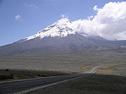
. Cotopaxi
Cotopaxi
Cotopaxi is a stratovolcano in the Andes Mountains, located about south of Quito, Ecuador, South America. It is the second highest summit in the country, reaching a height of...
in Ecuador is one of the world's highest active volcano
Volcano
2. Bedrock3. Conduit 4. Base5. Sill6. Dike7. Layers of ash emitted by the volcano8. Flank| 9. Layers of lava emitted by the volcano10. Throat11. Parasitic cone12. Lava flow13. Vent14. Crater15...
s. It also has a large series of cliff
Cliff
In geography and geology, a cliff is a significant vertical, or near vertical, rock exposure. Cliffs are formed as erosion landforms due to the processes of erosion and weathering that produce them. Cliffs are common on coasts, in mountainous areas, escarpments and along rivers. Cliffs are usually...
s that follow the southern border and spill into the northwest area of Peru.
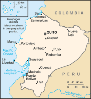
Area and borders
Ecuador is bounded on the west by the Pacific Ocean, and has 2,337 km of coastline. It has 2010 km of land boundaries, with ColombiaColombia
Colombia, officially the Republic of Colombia , is a unitary constitutional republic comprising thirty-two departments. The country is located in northwestern South America, bordered to the east by Venezuela and Brazil; to the south by Ecuador and Peru; to the north by the Caribbean Sea; to the...
in the north (590 km border) and Peru in the east and south (1,420 km border). Ecuador continues to contest the boundary with Peru, which was established by the Rio Protocol
Rio Protocol
The Protocol of Peace, Friendship, and Boundaries between Peru and Ecuador, or Rio Protocol for short, was an international agreement signed in Rio de Janeiro, Brazil, on January 29, 1942, by the foreign ministers of Peru and Ecuador, with the participation of the United States, Brazil, Chile, and...
of 1942 and ceded to Peru a large portion of territory east of the Andes.
Ecuador has a total area is 283560 km² (109,483 sq mi), including the Galápagos Islands
Galápagos Islands
The Galápagos Islands are an archipelago of volcanic islands distributed around the equator in the Pacific Ocean, west of continental Ecuador, of which they are a part.The Galápagos Islands and its surrounding waters form an Ecuadorian province, a national park, and a...
. Of this, 27840 km² (10,749 sq mi) is land and 6720 km² (2,595 sq mi) water. Ecuador is one of the smaller countries in South America, slightly smaller than the U.S. state
U.S. state
A U.S. state is any one of the 50 federated states of the United States of America that share sovereignty with the federal government. Because of this shared sovereignty, an American is a citizen both of the federal entity and of his or her state of domicile. Four states use the official title of...
of Nevada
Nevada
Nevada is a state in the western, mountain west, and southwestern regions of the United States. With an area of and a population of about 2.7 million, it is the 7th-largest and 35th-most populous state. Over two-thirds of Nevada's people live in the Las Vegas metropolitan area, which contains its...
.
Cities
The capital and second most-populous city is QuitoQuito
San Francisco de Quito, most often called Quito , is the capital city of Ecuador in northwestern South America. It is located in north-central Ecuador in the Guayllabamba river basin, on the eastern slopes of Pichincha, an active stratovolcano in the Andes mountains...
, with a population of 1.4 million. The most-populous city is Guayaquil
Guayaquil
Guayaquil , officially Santiago de Guayaquil , is the largest and the most populous city in Ecuador,with about 2.3 million inhabitants in the city and nearly 3.1 million in the metropolitan area, as well as that nation's main port...
(2 million). Other important cities include Cuenca (0.41 million), Ambato
San Juan de Ambato
Ambato is a city in located in the central Andean valley of Ecuador. Lying on the banks of the Ambato River, the city also sits beneath several tall mountains. It is the capital of the province of Tungurahua, at an elevation of 2,577 meters above sea level. The population is 180,000 , making it...
(0.28 million), Portoviejo
Portoviejo
Portoviejo is a city in Ecuador, and the capital the Province of Manabí 30 km from the Pacific coast. . Also known as the city of the "Royal Tamarind Trees" for the beautiful trees found in the area...
(0.23 million), Machala
Machala
Machala is a city in south-west Ecuador. It is the capital of the El Oro Province and located near the Gulf of Guayaquil on fertile lowlands. Machala has a population of 230,901 , making it the fourth biggest city of the country; it has been referred to as the Banana Capital of the...
(0.21 million), and Loja
Loja, Ecuador
Loja is the capital of Ecuador's Loja Province. It is located in the Cuxibamba valley in the south of the country, sharing borders with the provinces of Zamora-Chinchipe and El Oro, and with Peru in the south...
(0.14 million).
Geographical regions
Ecuador is divided into three continental regions—the Costa (coast), Sierra (mountains), and Oriente (east)—and one insular region, the Galápagos Islands (officially Archipiélago de Colón). The continental regions extend the length of the country from north to south and are separated by the Andes Mountains.Galápagos Islands
The Galápagos are located 1,000 km west of the Ecuadorian coast. They are noted for their association with Charles DarwinCharles Darwin
Charles Robert Darwin FRS was an English naturalist. He established that all species of life have descended over time from common ancestry, and proposed the scientific theory that this branching pattern of evolution resulted from a process that he called natural selection.He published his theory...
, whose observation of animals here during the voyage of the Beagle
Second voyage of HMS Beagle
The second voyage of HMS Beagle, from 27 December 1831 to 2 October 1836, was the second survey expedition of HMS Beagle, under captain Robert FitzRoy who had taken over command of the ship on its first voyage after her previous captain committed suicide...
led to his formation of the theory of natural selection
Natural selection
Natural selection is the nonrandom process by which biologic traits become either more or less common in a population as a function of differential reproduction of their bearers. It is a key mechanism of evolution....
as a means of evolution
Evolution
Evolution is any change across successive generations in the heritable characteristics of biological populations. Evolutionary processes give rise to diversity at every level of biological organisation, including species, individual organisms and molecules such as DNA and proteins.Life on Earth...
.
La Costa (the coast)
Pacific Ocean
The Pacific Ocean is the largest of the Earth's oceanic divisions. It extends from the Arctic in the north to the Southern Ocean in the south, bounded by Asia and Australia in the west, and the Americas in the east.At 165.2 million square kilometres in area, this largest division of the World...
to the west, encompasses a broad coastal plain, and then rises to the foothills of the Andes
Andes
The Andes is the world's longest continental mountain range. It is a continual range of highlands along the western coast of South America. This range is about long, about to wide , and of an average height of about .Along its length, the Andes is split into several ranges, which are separated...
Mountains to the east. It is estimated that 98% of the native forest of coastal Ecuador has been eliminated in favor of cattle ranching and other agricultural production, including banana
Banana
Banana is the common name for herbaceous plants of the genus Musa and for the fruit they produce. Bananas come in a variety of sizes and colors when ripe, including yellow, purple, and red....
, cacao and coffee
Coffee
Coffee is a brewed beverage with a dark,init brooo acidic flavor prepared from the roasted seeds of the coffee plant, colloquially called coffee beans. The beans are found in coffee cherries, which grow on trees cultivated in over 70 countries, primarily in equatorial Latin America, Southeast Asia,...
plantations. The forest fragments that still survive are primarily found along the coastal mountain ranges of Mache-Chindul, Jama-Coaque
Jama-Coaque Ecological Reserve
The Jama-Coaque Ecological Reserve is a 586-acre protected area of Pacific Equatorial Forest in coastal Ecuador. It is one of the last significant remnants of tropical moist evergreen forest and premontane cloud forest in the region between the Andes mountains and the Pacific Ocean in Ecuador...
, and Chongon-Colonche, and include tropical dry forest, tropical wet forest, tropical moist evergreen forest, premontane cloud forest, and mangrove forest. Collectively known as the Pacific Equatorial Forest
Pacific Equatorial Forest
The Pacific Equatorial Forest is a tropical forest ecosystem located at 0° latitude in coastal Ecuador, in the province of Manabí. The ecosystem is most notable for its high diversity of forest types in unusually close proximity...
, these forest remnants are considered the most endangered tropical forest in the world, and are part of the Tumbes-Choco-Magdalena biodiversity hotspot . Guayaquil
Guayaquil
Guayaquil , officially Santiago de Guayaquil , is the largest and the most populous city in Ecuador,with about 2.3 million inhabitants in the city and nearly 3.1 million in the metropolitan area, as well as that nation's main port...
, located on the southern part of the coast is the biggest city in the country. On the north coast of Ecuador the port of Balao in Esmeraldas is used for oil export and the port of Manta was formerly used by the United States Air Force
United States Air Force
The United States Air Force is the aerial warfare service branch of the United States Armed Forces and one of the American uniformed services. Initially part of the United States Army, the USAF was formed as a separate branch of the military on September 18, 1947 under the National Security Act of...
as a control point for narcotics traffic control until 2009.
La Sierra (the highlands)
Andes
The Andes is the world's longest continental mountain range. It is a continual range of highlands along the western coast of South America. This range is about long, about to wide , and of an average height of about .Along its length, the Andes is split into several ranges, which are separated...
Mountains, inland from the coast; with volcanoes and mountain peaks that sport year-round snow on the equator
Equator
An equator is the intersection of a sphere's surface with the plane perpendicular to the sphere's axis of rotation and containing the sphere's center of mass....
; many areas long since deforested by agriculture; a number of cut-flower growing operations; at a certain altitude zone may be found cloud forests.
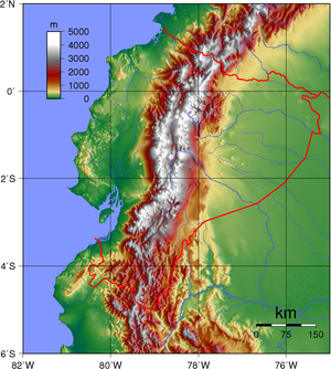
The northern Ecuadorian Andes are divided into three parallel cordillera
Cordillera
A cordillera is an extensive chain of mountains or mountain ranges, that runs along a coastline . It comes from the Spanish word cordilla, which is a diminutive of cuerda, or "cord"...
s which run in what is similar to an S-shape from north to south: the western, central (Cordillerra Real
Cordillera Real (Ecuador)
The Cordillera Real is a chain of mountains in the Andes of Ecuador, the largest of them volcanic. They are continued by the Cordillera Central of Peru to the south and the Cordillera Central of Colombia to the north...
) and eastern (Cordillera Occidental) cordilleras. The cordilleras were formed earlier in the Cenozoic
Cenozoic
The Cenozoic era is the current and most recent of the three Phanerozoic geological eras and covers the period from 65.5 mya to the present. The era began in the wake of the Cretaceous–Tertiary extinction event at the end of the Cretaceous that saw the demise of the last non-avian dinosaurs and...
era (the current geological era), as the Nazca Plate
Nazca Plate
]The Nazca Plate, named after the Nazca region of southern Peru, is an oceanic tectonic plate in the eastern Pacific Ocean basin off the west coast of South America. The ongoing subduction along the Peru-Chile Trench of the Nazca Plate under the South American Plate is largely responsible for the...
has subduct
Subduction
In geology, subduction is the process that takes place at convergent boundaries by which one tectonic plate moves under another tectonic plate, sinking into the Earth's mantle, as the plates converge. These 3D regions of mantle downwellings are known as "Subduction Zones"...
ed underneath the South American Plate
South American Plate
The South American Plate is a continental tectonic plate which includes the continent of South America and also a sizeable region of the Atlantic Ocean seabed extending eastward to the Mid-Atlantic Ridge....
and has raised the mountain range. In the south, the cordilleras are not well defined.
Quito
Quito
San Francisco de Quito, most often called Quito , is the capital city of Ecuador in northwestern South America. It is located in north-central Ecuador in the Guayllabamba river basin, on the eastern slopes of Pichincha, an active stratovolcano in the Andes mountains...
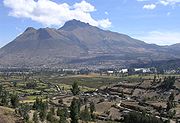
, the capital city, is located in a high mountain valley on the foothills of the Pichincha
Pichincha (volcano)
Pichincha is an active stratovolcano in the country of Ecuador, whose capital Quito wraps around its eastern slopes. The mountain's two highest peaks are the Guagua , which means "child" in Quechua and the Rucu , which means "old person". The active caldera is in the Guagua, on the western side of...
. The town of Baños
Baños
Baños de Agua Santa , commonly referred to as Baños, is a city in eastern Tungurahua Province, in central Ecuador. Baños is the second most populous city in Tungurahua, after Ambato, the capital, and is a major tourist center...
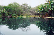
features hot spring
Hot spring
A hot spring is a spring that is produced by the emergence of geothermally heated groundwater from the Earth's crust. There are geothermal hot springs in many locations all over the crust of the earth.-Definitions:...
s swimming pools on the foothills of the Tungurahua
Tungurahua
Tungurahua, , rahua : "Throat of Fire" or from Panzaleo) is an active stratovolcano located in the Cordillera Oriental of Ecuador. The volcano gives its name to the province of Tungurahua...
in the Central Cordillera. The road from Baños to Puyo has long been known for its narrowness, curves and sheer drops (only one lane in some places, in one area, actually cut into the side of a cliff so that the cliff roofs over it). The most important east-west road across the Andes is the road from Quito to Lago Agrio, which is unpaved for most of its length yet is heavily traveled by tractor-trailers—and the Trans-Ecuadorian Oil Pipeline serves as the guardrail for long stretches of this road.
Notable Mountains and Volcanoes
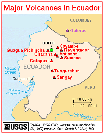
- ChimborazoChimborazo (volcano)Chimborazo is a currently inactive stratovolcano located in the Cordillera Occidental range of the Andes. Its last known eruption is believed to have occurred around 550 AD....
(6,267 m) extinct volcano, the furthest point from the Earth's center - CotopaxiCotopaxiCotopaxi is a stratovolcano in the Andes Mountains, located about south of Quito, Ecuador, South America. It is the second highest summit in the country, reaching a height of...
(5,897 m) the second highest active volcano in the world. - IllinizaIllinizaThe Illinizas are a pair of mountains that are located to the south of Quito. They are found in the ecological reserve that shares its name with the mountains. These twin mountains are separated in the middle by a saddle that is about a kilometer long...
(5,248 m) - TungurahuaTungurahuaTungurahua, , rahua : "Throat of Fire" or from Panzaleo) is an active stratovolcano located in the Cordillera Oriental of Ecuador. The volcano gives its name to the province of Tungurahua...
(5,023 m) It is an active volcano in eruption since 1998 near Baños-Tunguragua - PichinchaPichincha (volcano)Pichincha is an active stratovolcano in the country of Ecuador, whose capital Quito wraps around its eastern slopes. The mountain's two highest peaks are the Guagua , which means "child" in Quechua and the Rucu , which means "old person". The active caldera is in the Guagua, on the western side of...
(4,784 m) volcano overlooking Quito
Partial, incomplete table of volcanoes in the north of the Ecuadorian Andes, from north to south:
| West | Interandean | Center | East |
| Chiles Yanaurcu Pichincha Pichincha (volcano) Pichincha is an active stratovolcano in the country of Ecuador, whose capital Quito wraps around its eastern slopes. The mountain's two highest peaks are the Guagua , which means "child" in Quechua and the Rucu , which means "old person". The active caldera is in the Guagua, on the western side of... Atacazo Corazón Corazón Corazón is an inactive eroded stratovolcano of Ecuador, situated about 30 km southwest of Quito in the western slopes of the Andes.... Carihuairazo Chimborazo Chimborazo (volcano) Chimborazo is a currently inactive stratovolcano located in the Cordillera Occidental range of the Andes. Its last known eruption is believed to have occurred around 550 AD.... |
Imbabura Mojanda Ilaló Pasochoa Rumiñahui Rumiñahui (volcano) Rumiñahui is a dormant, heavily-eroded stratovolcano above sea level. Situated in the Andes mountains 40 km south of Quito, Ecuador, it is overshadowed by its famous neighbour Cotopaxi.... |
Cayambe Cayambe (volcano) Cayambe is the name of a volcano located in the Cordillera Oriental, a branch of the Ecuadorian Andes. It is located in Pichincha province some 70 km northeast of Quito. It is the third highest mountain in Ecuador.... Saraurcu Pambamarca Filocorrales Antisana Antisana Antisana is a stratovolcano of the northern Andes, in Ecuador. It is the fourth highest volcano in Ecuador, at , and is located 50 km SE of the capital city of Quito.Antisana presents one of the most challenging technical climbs in the Ecuadorian Andes.... Sincholahua Cotopaxi Cotopaxi Cotopaxi is a stratovolcano in the Andes Mountains, located about south of Quito, Ecuador, South America. It is the second highest summit in the country, reaching a height of... Tungurahua Tungurahua Tungurahua, , rahua : "Throat of Fire" or from Panzaleo) is an active stratovolcano located in the Cordillera Oriental of Ecuador. The volcano gives its name to the province of Tungurahua... Altar El Altar El Altar is an extinct volcano on the western side of Sangay National Park in Ecuador, 170 km south of Quito. Spaniards named it so because it resembled two Nuns and four Friars listening to a Bishop around a church altar... |
Soche Sumaco Reventador Reventador Reventador is an active stratovolcano which lies in the eastern Andes of Ecuador. It lies in a remote area of the national park of the same name. Since 1541 it has erupted over 25 times, although its isolated location means that many of its eruptions have gone unreported. Its most recent eruption... Sangay Sangay Sangay is a constantly active stratovolcano in central Ecuador. It is the southernmost and most active volcano in the country, and is known for its explosive venting of thick ash clouds, which has built a dome since 1976.-See also:... |
El Oriente (the East) Amazon Basin
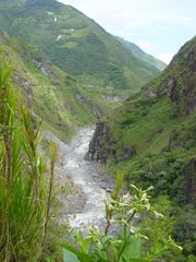
Much of the Oriente is tropical moist broadleaf forest (Spanish: la selva), on the east slopes of the AndesAndes
The Andes is the world's longest continental mountain range. It is a continual range of highlands along the western coast of South America. This range is about long, about to wide , and of an average height of about .Along its length, the Andes is split into several ranges, which are separated...
Mountains and descending into the Amazon Basin
Amazon Basin
The Amazon Basin is the part of South America drained by the Amazon River and its tributaries that drains an area of about , or roughly 40 percent of South America. The basin is located in the countries of Bolivia, Brazil, Colombia, Ecuador, Guyana, Peru, and Venezuela...
, with strikingly different upland rainforest with steep, rugged ridges and cascading streams (can be seen around Puyo
Puyo
Puyo refers to;* Puyo, Pastaza, the capital of Pastaza, a province in Ecuador* Buyeo , or Puyo, an ancient Korean kingdom* Buyeo County, in South Korea* Puyo , a Japanese manga artist* Puyo Pop/Puyo Puyo, a Japanese video game...
) and lowland rainforest. The oil fields are located in the Amazon basin, headquartered at Lago Agrio; some of the rainforest has been seriously damaged in this region and environmental degradation is severe, with catastrophic oil pollution in some areas. Some 38% of Ecuador's land is forested, and despite a 1.5% annual deforestation rate remains one of the most biodiverse
Biodiversity
Biodiversity is the degree of variation of life forms within a given ecosystem, biome, or an entire planet. Biodiversity is a measure of the health of ecosystems. Biodiversity is in part a function of climate. In terrestrial habitats, tropical regions are typically rich whereas polar regions...
locations on the planet. The Oriente is also home to a large number of Ecuador's indigenous groups, notably the lowland Quechua
Quechuas
Quechuas is the collective term for several indigenous ethnic groups in South America who speak a Quechua language , belonging to several ethnic groups in South America, especially in Peru, Ecuador, Bolivia, Chile, Colombia and Argentina.The Quechuas of Ecuador call themselves as well as their...
, Siona
Siona people
The Siona people are an indigenous ethnic group living in the Ecuadorian Amazon or Oriente , and in Colombia...
, Secoya, Huaorani
Huaorani
The Huaorani, Waorani or Waodani, also known as the Waos, are native Amerindians from the Amazonian Region of Ecuador who have marked differences from other ethnic groups from Ecuador. The alternate name Auca is a pejorative exonym used by the neighboring Quechua Indians, and commonly adopted by...
, and Cofán
Cofán
The Cofán people are an indigenous people native to Napo Province northeast Ecuador and to southern Colombia, between the Guamués River and the Aguaricó River...
.
In addition, Ecuador still lays claim to a large area of lowland rainforest to the east of this region, although Peru invaded it years ago and has held it ever since.
Drainage
In the Costa region, the Costa Externa has mostly intermittent rivers that are fed by constant rains from December through May and become empty riverbeds during the dry season. The few exceptions are the longer, perennial rivers that flow throughout the Costa Externa from the Costa Internal and the Sierra on their way to the Pacific Ocean. The Costa Internal, by contrast, is crossed by perennial rivers that may flood during the rainy season, sometimes forming swamps.
The Guayas River system, which flows southward to the Gulf of Guayaquil, constitutes the most important of the drainage systems in the Costa Internal. The Guayas River Basin, including land drained by its tributaries, is 40,000 square kilometers in area. The sixty-kilometer-long Guayas River forms just north of Guayaquil out of the confluence of the Babahoyo and Daule rivers. Briefly constricted at Guayaquil by hills, the Guayas widens south of the city and flows through a deltaic network of small islands and channels. At its mouth, the river forms a broad estuary with two channels around Puná Island, the deeper of which is used for navigation.
The second major Costa river system—the Esmeraldas—rises in the Hoya de Quito in the Sierra as the Guayllabamba River and flows westward to empty into the Pacific Ocean near the city of Esmeraldas. The Esmeraldas River is 320 kilometers long and has a 20,000-square-kilometer drainage basin.
Major rivers in the Oriente include the Pastaza
Pastaza River
The Pastaza is a large tributary to the Amazon River.It has its headwaters in the province of Tungurahua, where the Tambo River joins the Latacunga River, near the foot of the Volcano Tungurahua, flowing south-east towards the Amazon Basin...
, Napo
Napo River
The Napo is a tributary to the Amazon River that rises in Ecuador on the flanks of the volcanoes of Antisana, Sincholagua and Cotopaxi.The total length of 1075 km. Catchment area of 100,518 square kilometers...
, and Putumayo
Putumayo River
The Içá or Putumayo River is one of the tributaries of the Amazon River, west of and parallel to the Yapura. It forms part of Colombia's border with Ecuador, as well as most of the frontier with Peru...
. The Pastaza is formed by the confluence of the Chambo and the Patate rivers, both of which rise in the Sierra. The Pastaza includes the Agoyan waterfall, which at sixty-one meters is the highest waterfall in Ecuador. The Napo rises near Mount Cotopaxi and is the major river used for transport in the Eastern lowlands. The Napo ranges in width from 500 to 1,800 meters. In its upper reaches, the Napo flows rapidly until the confluence with one of its major tributaries, the Coca River, where it slows and levels off. The Putumayo forms part of the border with Colombia. All of these rivers flow into the Amazon River. The Galápagos Islands have no significant rivers. Several of the larger islands, however, have freshwater springs.
Climate
Each region has different factors that affect its climate. The Costa is influenced primarily by proximity to warm or cool ocean currents. By contrast, climate in the Sierra varies more as a function of altitude. The Oriente has a fairly uniform climate that varies only slightly between the two subregions. Climate in the Galápagos Islands is both moderated by the ocean currents and affected by altitude. Throughout Ecuador variation in rainfall primarily determines seasons. Temperature is determined by altitude. With each ascent of 200 metres (656 ft) in altitude, temperature drops 1 C-change. This phenomenon is particularly significant in the Sierra.The Costa and The Galapagos Islands
The Costa has a tropical climate. Temperatures for the region as a whole remain fairly constant, ranging from 23 °C (73.4 °F) in the south to 26 °C (78.8 °F) in the north. Although seasonal changes in temperature are not pronounced, the hottest period occurs during the rainy season, especially from February to April. Near Guayaquil, the coolest months are August and September. Rainfall in the Costa decreases from north to south, with vegetation changing from tropical rainforest in the north to tropical savannah to desert in the south.Differences in temperature and rainfall in the Costa are caused by the Peruvian Current and periodic appearances of El Niño. The Peruvian Current, also formerly known as the Humboldt, is a cold ocean current that flows north along the coasts of Chile and Peru. At Cabo Blanco, where the Gulf of Guayaquil begins, the main current veers to the west; a branch continues northward to Cabo Pasado, in Manabí Province, where it also turns westward to merge with the main current near the Galápagos Islands. The cold water and air temperatures associated with the Peruvian Current inhibit rainfall along the coast, creating dry to arid conditions. This effect is greatest along the southern coast of Ecuador.
The El Niño occurs periodically every six or seven years. Starting in late December, a change in atmospheric pressure shifts ocean currents so that warm waters come closer to shore and displace the cold waters. During this time, air and water temperatures, tides, sea levels and wave heights, and relative humidity all are higher than usual. These conditions produce heavy rainfall that generally lasts until May in an area that normally experiences nothing more than a drizzle. The resulting flooding and landslides can be devastating.
When the Peruvian Current is dominant, the amount of precipitation along the coast varies from north to south, with levels ranging from 3000 to 300 mm (118.1 to 11.8 in), respectively. Two rainy seasons in the northernmost part of the coast become a single season (December through June) not far south. Near Esmeraldas, average annual rainfall is 250 centimetres (98.4 in). The rainy season shortens farther south, lasting only from January to May at Guayaquil. Very little rainfall occurs on the end of the Santa Elena Peninsula west of Guayaquil. Arid conditions prevail on the border with Peru south of the Gulf of Guayaquil.
Separated from the effects of ocean currents by the Cordillera Costañera, the Costa Internal has a hot and humid climate. Temperatures can surpass 26 °C (78.8 °F), and the vegetation and cloud cover tend to retain and augment the heat. Rain is constant during the winter months of December through May, with the heaviest rainfall occurring in February and March.
The Sierra
Temperatures in the Sierra do not vary greatly on a seasonal basis; the hottest month averages 16 °C (60.8 °F) and the coolest month, 13 °C (55.4 °F) in the upper elevations. Diurnal temperatures, however, vary dramatically, from cold mornings to hot afternoons. The almost vertical sun and the rarefied air in the higher Sierra region allow the land to warm quickly during the day and lose heat quickly at night. Mornings typically are bright and sunny, whereas afternoons often are cloudy and rainy. In general, rainfall amounts are highest on exposed locations at lower altitudes. Rain also can vary on a local basis. Sheltered valleys normally receive 500 millimetres (19.7 in) per year, whereas annual rainfall is 1500 millimetres (59.1 in) in Quito and can reach 2500 millimetres (98.4 in) on exposed slopes that catch rain-bearing winds. On a seasonal basis, the driest months are June through September.Climate in the Sierra is divided into levels based on altitude. The tropical level—400 to 1800 m (1,312.3 to 5,905.5 ft)—has temperatures ranging from 20 to 25 °C (68 to 77 °F) and heavy precipitation. The subtropical level—1800 to 2500 m (5,905.5 to 8,202.1 ft)—has temperatures from 15 to 20 °C (59 to 68 °F) and moderate precipitation. The temperate level—2500 to 3200 m (8,202.1 to 10,498.7 ft)- -has a year-round temperature in the range of 10 to 15 °C (50 to 59 °F) and an annual rainfall of 1000 millimetres (39.4 in). The temperate level experiences rainstorms, hailstorms, and fog. Winter, or the rainy season, lasts from January through June, and the dry season or summer from July through December. Most rain falls in April. There also is a short rainy period in early October caused by moisture penetrating the Sierra from the Oriente. Quito and most other populated areas in the Sierra are located at this temperate level. The cold level extends from the temperate zone to 4650 metres (15,256 ft). Here, average temperatures are 3 to 9 °C (37.4 to 48.2 °F), and the precipitation often appears in the form of rain, hail, and thick fog. Above 4650 metres (15,256 ft) is the frozen level, where peaks are constantly capped with snow and ice, and temperatures range from below 0 to 3 °C (32 to 37.4 °F). Precipitation frequently is in the form of snow, fog, and rain.
The Oriente/Amazon Basin
The Eastern lowlands in the Oriente experience an equatorial climate. Rainfall is abundant, especially in the Andean piedmont, sometimes exceeding 5000 millimetres (196.9 in) per year. Temperatures average 25 °C (77 °F) in the western parts of this region. The jungle-covered plains of the Eastern lowlands register high levels of rainfall and temperatures surpassing 28 °C (82.4 °F).Being located on the equator, the Galápagos Islands would have an equatorial climate were it not for the modifying effects of the Peruvian Current. Instead, climate on the islands follows a pattern more like that of the Sierra than the Costa. At sea level, the land is desertlike with temperatures of 21 °C (69.8 °F). The eight summer months experience no precipitation, whereas the winter months of January through April have some fog and drizzle. Above sea level
Above mean sea level
The term above mean sea level refers to the elevation or altitude of any object, relative to the average sea level datum. AMSL is used extensively in radio by engineers to determine the coverage area a station will be able to reach...
to an altitude of 450 metres (1,476 ft), the islands have a mixture of tropical, subtropical, and temperate climates. In general, temperatures are around 17 °C (62.6 °F). There is constant fog and drizzle in the summer and rain in the winter. The cold level above 450 metres (1,476 ft) has temperatures below 14 °C (57.2 °F). It is cool along the tropical coast.
Natural resources
Ecuador has land which is rich in petroleum. Main fishing products include herring and mackerel. Other natural resources include timber and hydropowerLand use
- arable land: 6%
- permanent crops: 5%
- permanent pastures: 18%
- forests and woodland: 56%
- other: 15% (1993 est.)
Natural hazards
frequent earthquakeEarthquake
An earthquake is the result of a sudden release of energy in the Earth's crust that creates seismic waves. The seismicity, seismism or seismic activity of an area refers to the frequency, type and size of earthquakes experienced over a period of time...
s, landslides, volcanic
Volcano
2. Bedrock3. Conduit 4. Base5. Sill6. Dike7. Layers of ash emitted by the volcano8. Flank| 9. Layers of lava emitted by the volcano10. Throat11. Parasitic cone12. Lava flow13. Vent14. Crater15...
activity; periodic droughts and floods
Environment - current issues
deforestation; soil erosion; desertification; water pollutionPollution
Pollution is the introduction of contaminants into a natural environment that causes instability, disorder, harm or discomfort to the ecosystem i.e. physical systems or living organisms. Pollution can take the form of chemical substances or energy, such as noise, heat or light...
; pollution from oil production wastes
Environment - international agreements
- party to: Antarctic Treaty, Antarctic-Environmental Protocol, BiodiversityBiodiversityBiodiversity is the degree of variation of life forms within a given ecosystem, biome, or an entire planet. Biodiversity is a measure of the health of ecosystems. Biodiversity is in part a function of climate. In terrestrial habitats, tropical regions are typically rich whereas polar regions...
, Climate ChangeUnited Nations Framework Convention on Climate ChangeThe United Nations Framework Convention on Climate Change is an international environmental treaty produced at the United Nations Conference on Environment and Development , informally known as the Earth Summit, held in Rio de Janeiro from June 3 to 14, 1992...
, DesertificationDesertificationDesertification is the degradation of land in drylands. Caused by a variety of factors, such as climate change and human activities, desertification is one of the most significant global environmental problems.-Definitions:...
, Endangered SpeciesEndangered speciesAn endangered species is a population of organisms which is at risk of becoming extinct because it is either few in numbers, or threatened by changing environmental or predation parameters...
, Hazardous Wastes, Nuclear Test Ban, Ozone Layer Protection, Ship Pollution, Tropical Timber 83, Tropical Timber 94, Wetlands, WhalingWhalingWhaling is the hunting of whales mainly for meat and oil. Its earliest forms date to at least 3000 BC. Various coastal communities have long histories of sustenance whaling and harvesting beached whales...
- signed, but not ratified: Climate Change-Kyoto ProtocolKyoto ProtocolThe Kyoto Protocol is a protocol to the United Nations Framework Convention on Climate Change , aimed at fighting global warming...
Antipodes
Most of Ecuador is antipodalAntipodes
In geography, the antipodes of any place on Earth is the point on the Earth's surface which is diametrically opposite to it. Two points that are antipodal to one another are connected by a straight line running through the centre of the Earth....
to Malaya
Malay Peninsula
The Malay Peninsula or Thai-Malay Peninsula is a peninsula in Southeast Asia. The land mass runs approximately north-south and, at its terminus, is the southern-most point of the Asian mainland...
and Sumatra
Sumatra
Sumatra is an island in western Indonesia, westernmost of the Sunda Islands. It is the largest island entirely in Indonesia , and the sixth largest island in the world at 473,481 km2 with a population of 50,365,538...
. The southeast, along the border with Peru, corresponds to the heavily populated western coast of Malaya, from the city of Ipoh
Ipoh
Ipoh is the capital city of Perak state, Malaysia. It is approximately 200 km north of Kuala Lumpur on the North-South Expressway....
(opposite the southern corner of Ecuador), through the capital Kuala Lumpur
Kuala Lumpur
Kuala Lumpur is the capital and the second largest city in Malaysia by population. The city proper, making up an area of , has a population of 1.4 million as of 2010. Greater Kuala Lumpur, also known as the Klang Valley, is an urban agglomeration of 7.2 million...
, to Singapore
Singapore
Singapore , officially the Republic of Singapore, is a Southeast Asian city-state off the southern tip of the Malay Peninsula, north of the equator. An island country made up of 63 islands, it is separated from Malaysia by the Straits of Johor to its north and from Indonesia's Riau Islands by the...
and some of its neighboring Riau Islands (opposite the eastern corner of Ecuador). The north and west, including the main cities of Guayaquil and Quito and nearly all Ecuador's coast and border with Colombia, is antipodal to central Sumatra, from Riau Province up to the shores of Lake Toba
Lake Toba
Lake Toba is a lake and supervolcano. The lake is 100 kilometres long and 30 kilometres wide, and 505 metres at its deepest point. Located in the middle of the northern part of the Indonesian island of Sumatra with a surface elevation of about , the lake stretches from to...
(just off the westernmost point of Ecuador). Few cities coincide, but Esmeraldas, Ecuador
Esmeraldas, Ecuador
Esmeraldas is a coastal city in northwestern Ecuador. It is the seat of the Esmeraldas Canton and the capital of the Esmeraldas Province. It has an international sea port and a small airport ....
is directly antipodal to Padang, West Sumatra.