

Geography of East Timor
Encyclopedia
Geography
Geography is the science that studies the lands, features, inhabitants, and phenomena of Earth. A literal translation would be "to describe or write about the Earth". The first person to use the word "geography" was Eratosthenes...
of East Timor
East Timor
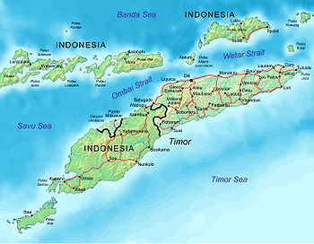
The Democratic Republic of Timor-Leste, commonly known as East Timor , is a state in Southeast Asia. It comprises the eastern half of the island of Timor, the nearby islands of Atauro and Jaco, and Oecusse, an exclave on the northwestern side of the island, within Indonesian West Timor...
.
Location:
- Southeast AsiaSoutheast AsiaSoutheast Asia, South-East Asia, South East Asia or Southeastern Asia is a subregion of Asia, consisting of the countries that are geographically south of China, east of India, west of New Guinea and north of Australia. The region lies on the intersection of geological plates, with heavy seismic...
(or OceaniaOceaniaOceania is a region centered on the islands of the tropical Pacific Ocean. Conceptions of what constitutes Oceania range from the coral atolls and volcanic islands of the South Pacific to the entire insular region between Asia and the Americas, including Australasia and the Malay Archipelago...
depending on definitions) , northwest of AustraliaAustraliaAustralia , officially the Commonwealth of Australia, is a country in the Southern Hemisphere comprising the mainland of the Australian continent, the island of Tasmania, and numerous smaller islands in the Indian and Pacific Oceans. It is the world's sixth-largest country by total area...
in the Lesser Sunda IslandsLesser Sunda IslandsThe Lesser Sunda Islands or Nusa Tenggara are a group of islands in the southern Maritime Southeast Asia, north of Australia. Together with the Greater Sunda Islands to the west they make up the Sunda Islands...
at the eastern end of the Indonesian archipelagoIslands of IndonesiaThis is a list of islands of Indonesian Archipelago. Indonesia comprises 17,508 - 18,306 islands and 8,844 that have been named according to estimates made by the Government of Indonesia, with 922 of those permanently inhabited. The islands span eastward from Sabang in northern Sumatra to Merauke...
; note - East Timor includes the eastern half of the island of TimorTimorTimor is an island at the southern end of Maritime Southeast Asia, north of the Timor Sea. It is divided between the independent state of East Timor, and West Timor, belonging to the Indonesian province of East Nusa Tenggara. The island's surface is 30,777 square kilometres...
, the Ocussi-Ambeno region on the northwest portion of the island of Timor, and the islands of Atauro and JacoJaco (East Timor)Jaco is a small island in the Lesser Sunda Islands. It lies across from the easternmost point of the island of Timor, Kap Cutcha. Its geographical coordinates are 8° 27' S and 127° 20' E. Politically it is part of the subdistrict of Tutuala within Lautém district of East Timor...
Geographic coordinates:
- 8°50′S 125°55′E
Map references:
- Southeast AsiaSoutheast AsiaSoutheast Asia, South-East Asia, South East Asia or Southeastern Asia is a subregion of Asia, consisting of the countries that are geographically south of China, east of India, west of New Guinea and north of Australia. The region lies on the intersection of geological plates, with heavy seismic...
, WallaceaWallaceaWallacea is a biogeographical designation for a group of Indonesian islands separated by deep water straits from the Asian and Australian continental shelves. Wallacea includes Sulawesi, the largest island in the group, as well as Lombok, Sumbawa, Flores, Sumba, Timor, Halmahera, Buru, Seram, and...
Area
Area
Area is a quantity that expresses the extent of a two-dimensional surface or shape in the plane. Area can be understood as the amount of material with a given thickness that would be necessary to fashion a model of the shape, or the amount of paint necessary to cover the surface with a single coat...
:
- Total: 14,874 km²
- Land: NA km²
- Water: NA km²
Land boundaries:
- Total: 228 km (142 mi)
- Border countries: IndonesiaIndonesiaIndonesia , officially the Republic of Indonesia , is a country in Southeast Asia and Oceania. Indonesia is an archipelago comprising approximately 13,000 islands. It has 33 provinces with over 238 million people, and is the world's fourth most populous country. Indonesia is a republic, with an...
(228 km (142 mi))
Coastline:
- 6789 km (4,218 mi)
Maritime claims:
- Contiguous zone: NA nmiNautical mileThe nautical mile is a unit of length that is about one minute of arc of latitude along any meridian, but is approximately one minute of arc of longitude only at the equator...
- Extended fishing zone: NA nmi
- Territorial sea: NA nmi
- Exclusive fishing zone: NA nmi
- Continental shelf: NA nmi
- Exclusive economic zone: NA nmi
ClimateClimateClimate encompasses the statistics of temperature, humidity, atmospheric pressure, wind, rainfall, atmospheric particle count and other meteorological elemental measurements in a given region over long periods...
- Tropical; hot, humid; distinct rainy and dry seasons
Terrain:
- MountainMountainImage:Himalaya_annotated.jpg|thumb|right|The Himalayan mountain range with Mount Everestrect 58 14 160 49 Chomo Lonzorect 200 28 335 52 Makalurect 378 24 566 45 Mount Everestrect 188 581 920 656 Tibetan Plateaurect 250 406 340 427 Rong River...
ous
Elevation extremes:
- Lowest point: Timor SeaTimor SeaThe Timor Sea is a relatively shallow sea bounded to the north by the island of Timor, to the east by the Arafura Sea, to the south by Australia and to the west by the Indian Ocean....
, Savu SeaSavu SeaThe Savu Sea is a small sea within Indonesia named for the island of Savu on its southern boundary. It is bounded by Savu and Rai Jua to the south, the islands of Rote and Timor to the east, Flores and the Alor archipelago to the north/northwest, and the island of Sumba to the west/northwest...
, and Banda SeaBanda SeaThe Banda Sea is a sea in the Maluku Islands of Indonesia, technically part of the Pacific Ocean but separated from it by hundreds of islands, as well as the Halmahera and Ceram Seas...
0 m - Highest point: Tatamailau (2963 m (9,721 ft))
Natural resource
Natural resource
Natural resources occur naturally within environments that exist relatively undisturbed by mankind, in a natural form. A natural resource is often characterized by amounts of biodiversity and geodiversity existent in various ecosystems....
s:
- GoldGoldGold is a chemical element with the symbol Au and an atomic number of 79. Gold is a dense, soft, shiny, malleable and ductile metal. Pure gold has a bright yellow color and luster traditionally considered attractive, which it maintains without oxidizing in air or water. Chemically, gold is a...
, petroleumPetroleumPetroleum or crude oil is a naturally occurring, flammable liquid consisting of a complex mixture of hydrocarbons of various molecular weights and other liquid organic compounds, that are found in geologic formations beneath the Earth's surface. Petroleum is recovered mostly through oil drilling...
, natural gasNatural gasNatural gas is a naturally occurring gas mixture consisting primarily of methane, typically with 0–20% higher hydrocarbons . It is found associated with other hydrocarbon fuel, in coal beds, as methane clathrates, and is an important fuel source and a major feedstock for fertilizers.Most natural...
, manganeseManganeseManganese is a chemical element, designated by the symbol Mn. It has the atomic number 25. It is found as a free element in nature , and in many minerals...
, marbleMarbleMarble is a metamorphic rock composed of recrystallized carbonate minerals, most commonly calcite or dolomite.Geologists use the term "marble" to refer to metamorphosed limestone; however stonemasons use the term more broadly to encompass unmetamorphosed limestone.Marble is commonly used for...
Land use:
- Arable land: NA%
- Permanent crops: NA%
- Other: NA%
Irrigated land:
- 1065 km² (411 sq mi) (est.)
Natural hazards:
- FloodFloodA flood is an overflow of an expanse of water that submerges land. The EU Floods directive defines a flood as a temporary covering by water of land not normally covered by water...
s and landslideLandslideA landslide or landslip is a geological phenomenon which includes a wide range of ground movement, such as rockfalls, deep failure of slopes and shallow debris flows, which can occur in offshore, coastal and onshore environments...
s are common; earthquakeEarthquakeAn earthquake is the result of a sudden release of energy in the Earth's crust that creates seismic waves. The seismicity, seismism or seismic activity of an area refers to the frequency, type and size of earthquakes experienced over a period of time...
s, tsunamiTsunamiA tsunami is a series of water waves caused by the displacement of a large volume of a body of water, typically an ocean or a large lake...
s
Environment
Natural environment
The natural environment encompasses all living and non-living things occurring naturally on Earth or some region thereof. It is an environment that encompasses the interaction of all living species....
- current issues:
- Widespread use of slash and burn agriculture has led to deforestationDeforestationDeforestation is the removal of a forest or stand of trees where the land is thereafter converted to a nonforest use. Examples of deforestation include conversion of forestland to farms, ranches, or urban use....
and soil erosionErosionErosion is when materials are removed from the surface and changed into something else. It only works by hydraulic actions and transport of solids in the natural environment, and leads to the deposition of these materials elsewhere...
Environment - international agreements:
Geography - note:
- Timor is the MalayMalay languageMalay is a major language of the Austronesian family. It is the official language of Malaysia , Indonesia , Brunei and Singapore...
word for "OrientEastEast is a noun, adjective, or adverb indicating direction or geography.East is one of the four cardinal directions or compass points. It is the opposite of west and is perpendicular to north and south.By convention, the right side of a map is east....
"; the island of Timor is part of the Malay Archipelago and is the largest and easternmost of the Lesser Sunda Islands. It was a portuguese territory until 1975, when it was invaded by Indonesia. - East Timor is the only Asian nation to lie entirely within the Southern Hemisphere.