

Geography of Colombia
Encyclopedia
 |
|
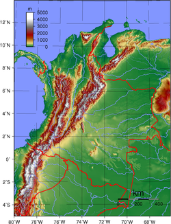
| Relief map of Colombia. (San Andres Archipielago not shown) |
|
| Area' | |
| Total | 2070408 km² (799,389 sq mi) |
| Land | 1141748 km² (440,831 sq mi) |
| Water | 928660 km² (358,558 sq mi) |
| Latitude | 4°0' N |
| Longitude | 72°0'W |
| Borders | |
| Venezuela | 2,850 km |
| Brazil | 1,653 km |
| Peru | 2,696 km 12,380 miles |
| Ecuador | 590 km |
| Panama | 225 km |
| Maritime claims | |
| Continental shelf | 200-m depth or to the depth of exploitation |
| Economic zone | 200 nmi (370.4 km; 230.2 mi) |
| Territorial sea | 12 nmi (22.2 km; 13.8 mi) |
The geography of Colombia
Colombia
Colombia, officially the Republic of Colombia , is a unitary constitutional republic comprising thirty-two departments. The country is located in northwestern South America, bordered to the east by Venezuela and Brazil; to the south by Ecuador and Peru; to the north by the Caribbean Sea; to the...
is characterized by containing five main natural region
Natural region
A Natural region is one which is distinguished by its natural features of geography and usually more important, geology. The natural ecology of the region is likely to be significant but one of these factors tends to influence the others....
s that present their own unique characteristics, from the Andes mountain range
Andes
The Andes is the world's longest continental mountain range. It is a continual range of highlands along the western coast of South America. This range is about long, about to wide , and of an average height of about .Along its length, the Andes is split into several ranges, which are separated...
region shared with Ecuador
Ecuador
Ecuador , officially the Republic of Ecuador is a representative democratic republic in South America, bordered by Colombia on the north, Peru on the east and south, and by the Pacific Ocean to the west. It is one of only two countries in South America, along with Chile, that do not have a border...
and Venezuela
Venezuela
Venezuela , officially called the Bolivarian Republic of Venezuela , is a tropical country on the northern coast of South America. It borders Colombia to the west, Guyana to the east, and Brazil to the south...
; the Pacific Ocean
Pacific Ocean
The Pacific Ocean is the largest of the Earth's oceanic divisions. It extends from the Arctic in the north to the Southern Ocean in the south, bounded by Asia and Australia in the west, and the Americas in the east.At 165.2 million square kilometres in area, this largest division of the World...
coastal
Pacific Coast
A country's Pacific coast is the part of its coast bordering the Pacific Ocean.-The Americas:Countries on the western side of the Americas have a Pacific coast as their western border.* Geography of Canada* Geography of Chile* Geography of Colombia...
region shared with Panama
Panama
Panama , officially the Republic of Panama , is the southernmost country of Central America. Situated on the isthmus connecting North and South America, it is bordered by Costa Rica to the northwest, Colombia to the southeast, the Caribbean Sea to the north and the Pacific Ocean to the south. The...
and Ecuador; the Caribbean Sea
Caribbean Sea
The Caribbean Sea is a sea of the Atlantic Ocean located in the tropics of the Western hemisphere. It is bounded by Mexico and Central America to the west and southwest, to the north by the Greater Antilles, and to the east by the Lesser Antilles....
coastal region shared with Venezuela and Panama; the Llanos
Llanos
The Llanos is a vast tropical grassland plain situated to the east of the Andes in Colombia and Venezuela, in northwestern South America. It is an ecoregion of the Flooded grasslands and savannas Biome....
(plains) shared with Venezuela; to the Amazon Rainforest
Amazon Rainforest
The Amazon Rainforest , also known in English as Amazonia or the Amazon Jungle, is a moist broadleaf forest that covers most of the Amazon Basin of South America...
region shared with Venezuela, Brazil
Brazil
Brazil , officially the Federative Republic of Brazil , is the largest country in South America. It is the world's fifth largest country, both by geographical area and by population with over 192 million people...
, Peru
Peru
Peru , officially the Republic of Peru , is a country in western South America. It is bordered on the north by Ecuador and Colombia, on the east by Brazil, on the southeast by Bolivia, on the south by Chile, and on the west by the Pacific Ocean....
and Ecuador. Colombia is the only South American country which borders both the Atlantic and Pacific Oceans.
Colombia is located in the northwestern region of South America
South America
South America is a continent situated in the Western Hemisphere, mostly in the Southern Hemisphere, with a relatively small portion in the Northern Hemisphere. The continent is also considered a subcontinent of the Americas. It is bordered on the west by the Pacific Ocean and on the north and east...
bordering to the east with Venezuela and Brazil; to the south with Ecuador and Peru; to the North with the Atlantic Ocean
Atlantic Ocean
The Atlantic Ocean is the second-largest of the world's oceanic divisions. With a total area of about , it covers approximately 20% of the Earth's surface and about 26% of its water surface area...
, through the Caribbean Sea
Caribbean Sea
The Caribbean Sea is a sea of the Atlantic Ocean located in the tropics of the Western hemisphere. It is bounded by Mexico and Central America to the west and southwest, to the north by the Greater Antilles, and to the east by the Lesser Antilles....
; and to the west with Panama
Panama
Panama , officially the Republic of Panama , is the southernmost country of Central America. Situated on the isthmus connecting North and South America, it is bordered by Costa Rica to the northwest, Colombia to the southeast, the Caribbean Sea to the north and the Pacific Ocean to the south. The...
and the Pacific Ocean
Pacific Ocean
The Pacific Ocean is the largest of the Earth's oceanic divisions. It extends from the Arctic in the north to the Southern Ocean in the south, bounded by Asia and Australia in the west, and the Americas in the east.At 165.2 million square kilometres in area, this largest division of the World...
. Colombia is the 26th largest nation in the world
World
World is a common name for the whole of human civilization, specifically human experience, history, or the human condition in general, worldwide, i.e. anywhere on Earth....
and the fourth-largest country in South America after Brazil, Argentina
Argentina
Argentina , officially the Argentine Republic , is the second largest country in South America by land area, after Brazil. It is constituted as a federation of 23 provinces and an autonomous city, Buenos Aires...
, and Peru. Despite its large territory, Colombia's population is not evenly distributed with most Colombians living in the mountainous western portion of the country as well as the northern coastline, most living in or near the capital city of Bogotá
Bogotá
Bogotá, Distrito Capital , from 1991 to 2000 called Santa Fé de Bogotá, is the capital, and largest city, of Colombia. It is also designated by the national constitution as the capital of the department of Cundinamarca, even though the city of Bogotá now comprises an independent Capital district...
. The southern and eastern portions of the country are mostly sparsely inhabited tropical rainforest and inland tropical plains containing small farming communities and indigenous tribes.
Natural regions
Colombia usually classifies its geography into five regions. Despite this The World FactbookThe World Factbook
The World Factbook is a reference resource produced by the Central Intelligence Agency of the United States with almanac-style information about the countries of the world. The official paper copy version is available from the National Technical Information Service and the Government Printing Office...
makes no difference between Amazon region of Colombia (predominantly jungle) and the Orinoquia region of Colombia (predominantly plains). The World Factbook considers most appropriate to divide the country into four geographic regions: the Andean highlands, consisting of the three Andean ranges and intervening valley lowlands; the Caribbean lowlands coastal region; the Pacific lowlands coastal region, separated from the Caribbean lowlands by swamps at the base of the Isthmus of Panama; and eastern Colombia, the great plain that lies to the east of the Andes Mountains
Andes
The Andes is the world's longest continental mountain range. It is a continual range of highlands along the western coast of South America. This range is about long, about to wide , and of an average height of about .Along its length, the Andes is split into several ranges, which are separated...
.
The chief western mountain range, the Cordillera Occidental, is a moderately high range with peaks reaching up to about 15000 ft (4,572 m) (4,670 m). The Cauca River Valley, an important agricultural region with several large cities on its borders, separates the Cordillera Occidental from the massive Cordillera Central
Cordillera Central
The Cordillera Central, meaning central range in Spanish, is used to refer to several mountain ranges around the world:* Cordillera Central, Andes , several mountain ranges in South America** Cordillera Central, Colombia...
. Several snow-clad volcanoes in the Cordillera Central have summits that rise above 17000 ft (5,182 m). The valley of the slow-flowing and muddy Magdalena River
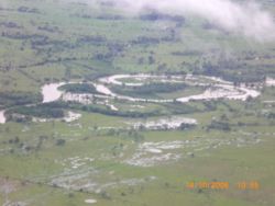
Magdalena River
The Magdalena River is the principal river of Colombia, flowing northward about through the western half of the country. It takes its name from the biblical figure Mary Magdalene. It is navigable through much of its lower reaches, in spite of the shifting sand bars at the mouth of its delta, as...
, a major transportation artery, separates the Cordillera Central from the main eastern range, the Cordillera Oriental. The peaks of the Cordillera Oriental are moderately high. This range differs from Colombia's other mountain ranges in that it contains several large basins. In the east, the sparsely populated, flat to gently rolling eastern lowlands called llanos
Llanos
The Llanos is a vast tropical grassland plain situated to the east of the Andes in Colombia and Venezuela, in northwestern South America. It is an ecoregion of the Flooded grasslands and savannas Biome....
cover almost 60 percent of the country's total land area.
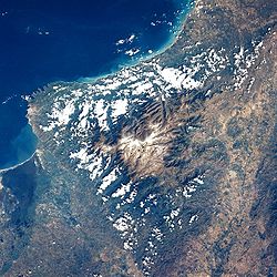
This cross section of the republic does not include two of Colombia's regions: the Caribbean coastal lowlands and the Sierra Nevada de Santa Marta
Sierra Nevada de Santa Marta
The Sierra Nevada de Santa Marta is an isolated mountain range apart from the Andes chain that runs through Colombia. Reaching an altitude of 5,700 metres above sea level just 42 km from the Caribbean coast, the Sierra Nevada is the world's highest coastal range...
, both in the northern part of the country. The lowlands in the west are mostly swampy; the reed-filled marshes of the area are called ciénagas by the people of Colombia. The Guajira Peninsula
Guajira Peninsula
Guajira Peninsula , is a peninsula in northern Colombia and northwestern Venezuela in the Caribbean Sea...
in the east is semiarid. The Sierra Nevada de Santa Marta
Sierra Nevada de Santa Marta
The Sierra Nevada de Santa Marta is an isolated mountain range apart from the Andes chain that runs through Colombia. Reaching an altitude of 5,700 metres above sea level just 42 km from the Caribbean coast, the Sierra Nevada is the world's highest coastal range...
is a spectacular triangular snowcapped block of rock that towers over the eastern part of this lowland. Here can be found the highest peak of the country named Pico Cristobal Colon
Pico Cristóbal Colón
Pico Cristóbal Colón is the highest mountain in Colombia and the fifth most prominent in the world . The nearest peak that is higher is Cayambe, some away. There is a permanent snowcap on this peak and on the nearby mountains. It is part of the Sierra Nevada de Santa Marta range, along with Pico...
(5775 m).
Andean region

Caribbean Sea
The Caribbean Sea is a sea of the Atlantic Ocean located in the tropics of the Western hemisphere. It is bounded by Mexico and Central America to the west and southwest, to the north by the Greater Antilles, and to the east by the Lesser Antilles....
. Altitudes reach more than 18700 ft (5,700 m), and mountain peaks are permanently covered with snow. The elevated basins and plateaus of these ranges have a moderate climate that provides pleasant living conditions and in many places enables farmers to harvest twice a year. Torrential rivers on the slopes of the mountains produce a large hydroelectric power
Hydroelectricity
Hydroelectricity is the term referring to electricity generated by hydropower; the production of electrical power through the use of the gravitational force of falling or flowing water. It is the most widely used form of renewable energy...
potential and add their volume to the navigable rivers in the valleys. In the late 1980s, approximately 78 percent of the country's population lived in the Andean highlands.
The Cordillera Occidental in the west, the Cordillera Central in the center, and the Cordillera Oriental in the east have different characteristics. Geologically, the Cordillera Occidental and the Cordillera Central form the western and eastern sides of a massive crystalline arch that extends from the Caribbean lowlands to the southern border of Ecuador. The Cordillera Oriental, however, is composed of folded stratified rocks overlying a crystalline core.
The Cordillera Occidental is relatively low and is the least populated of the three cordilleras. Summits are only about 9840 ft (2,999 m) above sea level and do not have permanent snows. Few passes exist, although one that is about 4985 ft (1,519 m) above sea level provides the major city of Cali
Santiago de Cali
Santiago de Cali , simply referred to as Cali, is a city in western Colombia and the capital of the Valle del Cauca Department. With a population of 2.5 million, Cali is the third largest city in the country. It has one of the fastest growing economies and infrastructure in the country because...
with an outlet to the Pacific Ocean
Pacific Ocean
The Pacific Ocean is the largest of the Earth's oceanic divisions. It extends from the Arctic in the north to the Southern Ocean in the south, bounded by Asia and Australia in the west, and the Americas in the east.At 165.2 million square kilometres in area, this largest division of the World...
. The relatively low elevation of the cordillera permits dense vegetation, which on the western slopes is truly tropical.
The Cordillera Occidental is separated from the Cordillera Central by the deep rift of the Cauca Valley. The Río Cauca rises within 124 mi (200 km) of the border with Ecuador
Ecuador
Ecuador , officially the Republic of Ecuador is a representative democratic republic in South America, bordered by Colombia on the north, Peru on the east and south, and by the Pacific Ocean to the west. It is one of only two countries in South America, along with Chile, that do not have a border...
and flows through some of the best farmland in the country. After the two cordilleras converge, the Cauca Valley becomes a deep gorge all the way to the Caribbean lowlands.
The Cordillera Central is the loftiest of the mountain systems. Its crystalline rocks form a towering wall dotted with snow-covered volcanoes that is 500 mi (805 km) long. There are no plateaus in this range and no passes under 10825 ft (3,299 m). The highest peak in this range, the Nevado del Huila
Nevado del Huila
Nevado del Huila , at , is the highest volcano in Colombia, located in Huila Department. After being dormant for more than 500 years, the volcano showed heavy signs of activity in 2007 and 2008. As of February 20, 2007, there were more than 7000 "minor" seismic events, and a high state of...
, reaches 17602 ft (5,365 m) above sea level. The second highest peak is a volcano, Nevado del Ruiz
Nevado del Ruiz
The Nevado del Ruiz, also known as La Mesa de Herveo or Kumanday in the language of the local pre-Columbian indigenous people, is a volcano located on the border of the departments of Caldas and Tolima in Colombia, about west of the capital city Bogotá. It is a stratovolcano, composed of many...
, which erupted violently on November 13, 1985. Toward its northern end, this cordillera separates into several branches that descend toward the Caribbean coast.
Between the Cordillera Central and the Cordillera Oriental flows the Magdalena River
Magdalena River
The Magdalena River is the principal river of Colombia, flowing northward about through the western half of the country. It takes its name from the biblical figure Mary Magdalene. It is navigable through much of its lower reaches, in spite of the shifting sand bars at the mouth of its delta, as...
. This 1600 kilometres (994 mi)-long river rises near a point some 180 km (112 mi) north of the border with Ecuador, where the Cordillera Oriental and the Cordillera Central diverge. Its spacious drainage area is fed by numerous mountain torrents originating high in the snowfields. The Magdalena River is generally navigable from the Caribbean Sea as far as the town of Neiva, deep in the interior, but is interrupted midway by rapids. The valley floor is very deep; nearly 800 km (497 mi) from the river's mouth the elevation is no more than about 300 metres (984 ft).
In the Cordillera Oriental at elevations between 2500 and 2700 m (8,202.1 and 8,858.3 ft), three large fertile basins and a number of small ones provide suitable areas for settlement and intensive economic production. In the basin of Cundinamarca
Cundinamarca Department
- Origin of the name :The name of Cundinamarca comes from Kundur marqa, an indigenous expression, probably derived from Quechua. Meaning "Condor's Nest", it was used in pre-Columbian times by the natives of the Magdalena Valley to refer to the nearby highlands....
, where the Spanish found the Chibcha Indians, the European invaders established the town of Santa Fe de Bogotá (present-day Bogotá
Bogotá
Bogotá, Distrito Capital , from 1991 to 2000 called Santa Fé de Bogotá, is the capital, and largest city, of Colombia. It is also designated by the national constitution as the capital of the department of Cundinamarca, even though the city of Bogotá now comprises an independent Capital district...
) at an elevation of 2650 metres (8,694 ft) above sea level.
To the north of Bogotá, in the densely populated basins of Chiquinquirá
Chiquinquirá
Chiquinquirá is a town and municipality in the Colombian Department of Boyacá, part of the subregion of the Western Boyacá Province. Located some 115 km north of Bogotá, Chiquinquirá is 2570m above sea level and has a yearly average temperature 58°F....
and Boyacá
Boyacá Department
Boyacá is one of the 32 Departments of Colombia, and the remnant of one of the original nine states of the "United States of Colombia".Boyacá is centrally located within Colombia, almost entirely within the mountains of the Eastern Cordillera to the border with Venezuela, although the western end...
, are fertile fields, rich mines, and large industrial establishments that produce much of the national wealth. Still farther north, where the Cordillera Oriental makes an abrupt turn to the northwest near the border with Venezuela
Venezuela
Venezuela , officially called the Bolivarian Republic of Venezuela , is a tropical country on the northern coast of South America. It borders Colombia to the west, Guyana to the east, and Brazil to the south...
, the highest point of this range, the Sierra Nevada de Cocuy, rises to 5493 metres (18,022 ft) above sea level. In the department of Santander
Santander Department
Santander is a department of Colombia. Santander inherited the name of one of the nine original states of the United States of Colombia. It is located in the central northern part of the country, east of the Magdalena River, bordered to the south and southeast by Boyacá, to the northeast by Norte...
, the valleys on the western slopes are more spacious, and agriculture is intensive in the area around Bucaramanga
Bucaramanga
Bucaramanga is a Colombian city, and capital city of the department of Santander, Colombia. Bucaramanga has the fifth largest city economy and sixth largest population in Colombia, with 1,212,656 people in its metropolitan area...
. The northernmost region of the range around Cúcuta
Cúcuta
Cúcuta is a Colombian city, capital of Norte de Santander, in the northeast of the country. Due to its proximity to the Colombian-Venezuelan border, Cúcuta is an important commercial center. The city has the constitutional category of Special District. It is located at the most active...
is so rugged that historically it has been easier to maintain communications and transportation with Venezuela than with the adjacent parts of Colombia.
Caribbean region
Gulf of Urabá
The Gulf of Urabá is a gulf on the northern coast of South America. It is part of the Caribbean Sea. It is a long narrow inlet in the coast of Colombia, close to the connection of the continent to the Isthmus of Panama. The town of Turbo lies at the southern end of the Gulf...
to the Venezuelan frontier at the northern extremity of the Cordillera Oriental. The semiarid Guajira Peninsula
Guajira Peninsula
Guajira Peninsula , is a peninsula in northern Colombia and northwestern Venezuela in the Caribbean Sea...
and Guajira-Barranquilla xeric scrub
Guajira-Barranquilla xeric scrub
The Guajira-Barranquilla xeric scrub is a xeric shrubland ecoregion in Colombia, covering an estimated area of 150.000 km2.-Setting:The ecoregion occupies the Guajira Peninsula, the valley of Rancheria river and Guajira Department, covering parts of the northeastern coast of Venezuela...
, in the extreme north, bear little resemblance to the rest of the region. In the southern part rises the Sierra Nevada de Santa Marta
Sierra Nevada de Santa Marta
The Sierra Nevada de Santa Marta is an isolated mountain range apart from the Andes chain that runs through Colombia. Reaching an altitude of 5,700 metres above sea level just 42 km from the Caribbean coast, the Sierra Nevada is the world's highest coastal range...
, an isolated mountain system with peaks reaching heights over 5700 metres (18,701 ft) and slopes generally too steep for cultivation.
The Caribbean lowlands region is in roughly the shape of a triangle, the longest side of which is the coastline. Most of the country's commerce moves through Cartagena, Barranquilla, Santa Marta, and the other ports located along this important coast. Inland from these cities are swamps, hidden streams, and shallow lakes that support banana and cotton plantations, countless small farms, and, in higher places, cattle ranches.
The city of Cartagena is primarily a tourist city, with some basic industry, such as Santa marta, but the latter is a smaller-scale city by comparison. Barranquilla is located some 25 miles (40 km) from the Caribbean coastline but it is a more advanced and developed city with a greater industrial capacity, widely known for its abilities in all forms of metalwork, construction and the development of science and engineering. Its inhabitants have the highest cultural level of the region and the city is famous for its technical and scientifical achievements being the starting point and focus of the region and the country's development as the first city in the country with the use of phones, public lighting, air mail, planes and industrial works as well as cultural events.
The Caribbean region merges into and is connected with the Andean highlands through the two great river valleys. After the Andean highlands, it is the second most important region in economic activity. Approximately 17% of the country's population lived in this region in the late 1980s.
The region also includes the peninsular archipelago of San Andres Island and the Insular Territories of Colombia, which are disputed in part by Nicaragua. However, the Colombian Navy protects such territories with the use of force when necessary to avoid drug trade or foreign invasion and the islands are home to 2 important bases for defense and custom controls, formerly used for research of classified projects with civilian assistance as the local universities often research in the area of oceanography and marine biology but also in the fields of biochemistry, genetics, immunology and Colombia is known for its advances in medical fields in experimental surgery, implant development or prosthetics and immunology and these facilities serve as containment and secure experimentation labs to complement those in Barranquilla and other undisclosed locations within the coast territories.
The Insular Region is considered by some as a geopolitical region of Colombia
Colombia
Colombia, officially the Republic of Colombia , is a unitary constitutional republic comprising thirty-two departments. The country is located in northwestern South America, bordered to the east by Venezuela and Brazil; to the south by Ecuador and Peru; to the north by the Caribbean Sea; to the...
which comprises the areas outside the continental territories of Colombia
Colombia
Colombia, officially the Republic of Colombia , is a unitary constitutional republic comprising thirty-two departments. The country is located in northwestern South America, bordered to the east by Venezuela and Brazil; to the south by Ecuador and Peru; to the north by the Caribbean Sea; to the...
and includes the San Andrés y Providencia Department in the Caribbean sea
Caribbean Sea
The Caribbean Sea is a sea of the Atlantic Ocean located in the tropics of the Western hemisphere. It is bounded by Mexico and Central America to the west and southwest, to the north by the Greater Antilles, and to the east by the Lesser Antilles....
and the Malpelo
Malpelo Island
Malpelo Island is an island located from Colombia's Pacific coast, and approximately from Panama's coast. It has a land area of . It is uninhabited except for a small military post manned by the Colombian Army, which was established in 1986. Visitors need a written permit from the Colombian...
and Gorgona
Gorgona, Colombia
Gorgona is a Colombian island in the Pacific Ocean situated about 50 km off the Colombian Pacific coast and part of the municipality of Guapi in the Department of Cauca. The island is about 9 km long and 2.5 km wide, with a maximum height of 338 m ; with an area of 10 square miles...
Islands in the Pacific Ocean
Pacific Ocean
The Pacific Ocean is the largest of the Earth's oceanic divisions. It extends from the Arctic in the north to the Southern Ocean in the south, bounded by Asia and Australia in the west, and the Americas in the east.At 165.2 million square kilometres in area, this largest division of the World...
. The Insular region subregions include other group of islands;
- Archipiélago de San Bernardo (in the Morrosquillo Gulf, Caribbean).
- Islas del RosarioIslas del RosarioThe Islas del Rosario is one of the 46 Natural National Parks of Colombia, created in order to protect one of the most important coral reefs of the Colombian Caribbean coast.-Characteristics:...
.(Caribbean) - Isla Fuerte.(Caribbean)
- Isla Barú.(Caribbean)
- Isla Tortuguilla.(Caribbean)
- Isla Tierra Bomba. (Caribbean)
On a special note, although the border between the Caribbean region and the Andes region has some presence of guerrilla left-wing exremist groups and some paramilitary right-wing groups, their presence is marginal in that area and even more minoritary in the rest of the Caribbean region, as opposed to the heavy presence and social infiltration they have in the inner side of the country where they are infiltrated in most levels of society and economic sectors or establishments and institutions while the government fights heavily to purge such insurgent infiltrates out of such cities. Arguably, it's the "peace zone" of the country for its low criminality, the low-level violence of its crimes and the absence of major organized crimes, gangs and the sort which make the regions afe for tourism from international visitors and this is due to the native people's desdain for the use of violence, brutality and for violent crime or aggression, in spite of being the region where the best and fiercest fighters in Boxing and other fighting and contact sports, martial arts and wrestling, and also where most of the male inhabitants and natives know one of such styles and follows it regularly on the news and sports broadcasts and shows.
Pacific region
The western third of the country is the most geographically complex. Starting at the shore of the Pacific Ocean in the west and moving eastward at a latitude of 5 degrees north5th parallel north
The 5th parallel north is a circle of latitude that is 5 degrees north of the Earth's equatorial plane. It crosses the Atlantic Ocean, Africa, the Indian Ocean, Southeast Asia, the Pacific Ocean and South America....
, a diverse sequence of features is encountered. In the extreme west are the very narrow and discontinuous Pacific coastal lowlands, which are backed by the Serranía de Baudó
Baudó Mountains
The Baudó Mountains are a coastal mountain range on the Pacific coast of Colombia. They are separated from the Cordillera Occidental by the Atrato valley where the Atrato River flows and Quibdó is located. From the south the range extends from the Baudó River north and slightly west along the...
, the lowest and narrowest of Colombia's mountain ranges. Next is the broad region of the Río Atrato
Atrato River
The Río Atrato is a river of northwestern Colombia. It rises in the slopes of the Western Cordillera and flows almost due north to the Gulf of Urabá , where it forms a large, swampy delta....
/Río San Juan
San Juan River (Colombia)
San Juan River is an important river of Colombia. It quoted source is in the Cordillera Occidental and has a length of 380 km...
lowland, which has been proposed as a possible alternate to the Panama Canal
Panama Canal
The Panama Canal is a ship canal in Panama that joins the Atlantic Ocean and the Pacific Ocean and is a key conduit for international maritime trade. Built from 1904 to 1914, the canal has seen annual traffic rise from about 1,000 ships early on to 14,702 vessels measuring a total of 309.6...
as a human-made route between the Atlantic and the Pacific oceans. Colombia occupies most of the Andes mountain range northern extremity sharing a bit with Venezuela which splits into three branches between the Colombia-Ecuador border.
In the 1980s, only 3% of all Colombians resided in the Pacific lowlands, a region of jungle and swamp with considerable but little-exploited potential in minerals and other resources. Buenaventura is the only port of any size on the coast. On the east, the Pacific lowlands are bounded by the Cordillera Occidental, from which numerous streams run. Most of the streams flow westward to the Pacific, but the largest, the navigable Río Atrato, flows northward to the Golfo de Urabá, making the river settlements accessible to the major Atlantic ports and commercially related primarily to the Caribbean lowlands hinterland. To the west of the Río Atrato rises the Serranía de Baudó
Baudó Mountains
The Baudó Mountains are a coastal mountain range on the Pacific coast of Colombia. They are separated from the Cordillera Occidental by the Atrato valley where the Atrato River flows and Quibdó is located. From the south the range extends from the Baudó River north and slightly west along the...
, an isolated chain of low mountains that occupies a large part of the region. Its highest elevation is less than 1,800 meters, and its vegetation resembles that of the surrounding tropical forest.
The Atrato Swamp
Darién Gap
The Darién Gap is a large swath of undeveloped swampland and forest separating Panama's Darién Province in Central America from Colombia in South America. It measures just over long and about wide. Roadbuilding through this area is expensive, and the environmental toll is steep. Political...
—in Chocó Department adjoining the border with Panama—is a deep muck sixty-five kilometers in width that for years has challenged engineers seeking to complete the Pan-American Highway
Pan-American Highway
The Pan-American Highway is a network of roads measuring about in total length. Except for an rainforest break, called the Darién Gap, the road links the mainland nations of the Americas in a connected highway system. According to Guinness World Records, the Pan-American Highway is the world's...
. This stretch, near Turbo
Turbo, Colombia
Turbo is a port town in Antioquia Department, Colombia. It is located at around . It is located on the coast of Gulf of Urabá, 340 km. north from Medellín...
, where the highway is interrupted is known as the Tapón del Chocó (Chocon Plug). A second major transportation project involving Chocó Department has been proposed. A second interoceanic canal would be constructed by dredging the Río Atrato and other streams and digging short access canals. Completion of either of these projects would do much to transform this region, although it could have devastating consequences on the fragile environment.
Orinoquía region
The area east of the Andes includes about 699,300 square kilometers, or three-fifths of the country's total area, but Colombians view it almost as an alien land. The entire area, known as the eastern plains, was home to only 2% of the country's population in the late 1980s. The Spanish term for plains (llanosLlanos
The Llanos is a vast tropical grassland plain situated to the east of the Andes in Colombia and Venezuela, in northwestern South America. It is an ecoregion of the Flooded grasslands and savannas Biome....
) can be applied only to the open plains in the northern part, particularly the piedmont areas near the Cordillera Oriental, where extensive cattle raising is practiced.
The region is unbroken by highlands except in Meta Department
Meta Department
Meta is a department of Colombia. It is close to the geographic center of the country, to the east of the Andean mountains. A large portion of the department, which is also crossed by the Meta River, is covered by a grassland plain known as the Llanos. Its capital is Villavicencio...
, where the Serranía de la Macarena
Serranía de la Macarena
Serranía de la Macarena is a Colombian mountain range located east of the Andes in the Meta Department. The mountains are separated by about 40 kilometers at their northern extreme from the Cordillera Oriental . The range is orientated from north to south and is 120 kilometers in length and 30...
, an out lier of the Andes has unique vegetation and wildlife believed to be reminiscent of those that once existed throughout the Andes.
Amazon region
Many of the numerous large rivers of eastern Colombia are navigational. The Río Guaviare and the streams to its north flow eastward and drain into the basin of the Río Orinoco, river that crosses into Venezuela and flows into the Atlantic Ocean. Those south of the Río Guaviare flow into the Amazon BasinAmazon Basin
The Amazon Basin is the part of South America drained by the Amazon River and its tributaries that drains an area of about , or roughly 40 percent of South America. The basin is located in the countries of Bolivia, Brazil, Colombia, Ecuador, Guyana, Peru, and Venezuela...
. The Río Guaviare divides eastern Colombia into the llanos subregion in the north and the tropical rainforest, or selva, subregion in the south.
Climate
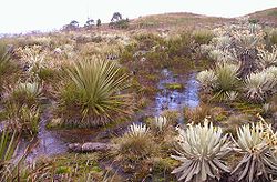
Colombians customarily describe their country in terms of the climatic zones: the area under 900 metres (2,953 ft) in elevation is called the hot zone (tierra caliente), elevations between 900 and 1980 m (2,952.8 and 6,496.1 ft) are the temperate zone (tierra templada), and elevations from 1980 metres (6,496 ft) to about 3500 metres (11,483 ft) constitute the cold zone (tierra fría). The upper limit of the cold zone marks the tree line and the approximate limit of human habitation. The treeless regions adjacent to the cold zone and extending to approximately 4500 metres (14,764 ft) are high, bleak areas (usually referred to as the páramos), above which begins the area of permanent snow (nevado).
About 86% of the country's total area lies in the hot zone. Included in the hot zone and interrupting the temperate area of the Andean highlands are the long and narrow extension of the Magdalena Valley and a small extension in the Cauca Valley. Temperatures, depending on elevation, vary between 24 and 38 °C (75.2 and 100.4 °F), and there are alternating dry and wet seasons corresponding to summer and winter, respectively. Breezes on the Caribbean coast, however, reduce both heat and precipitation.
Rainfall in the hot zone is heaviest in the Pacific lowlands and in parts of eastern Colombia, where rain is almost a daily occurrence and rain forests predominate. Precipitation exceeds 7600 millimetres (299.2 in) annually in most of the Pacific lowlands, making this one of the wettest regions in the world. The highest average annual precipitation in the world is estimated to be in Lloro, Colombia, with 13299 mm (523.6 in). In eastern Colombia, it decreases from 6350 millimetres (250 in) in portions of the Andean piedmont to 2540 millimetres (100 in) eastward. Extensive areas of the Caribbean interior are permanently flooded, more because of poor drainage than because of the moderately heavy precipitation during the rainy season from May through October.
The temperate zone covers about 8% of the country. This zone includes the lower slopes of the Cordillera Oriental and the Cordillera Central and most of the intermontane valleys. The important cities of Medellín (1487 metres (4,879 ft)) and Cali (1030 metres (3,379 ft)) are located in this zone, where rainfall is moderate and the mean annual temperature varies between 19 and 24 °C (66.2 and 75.2 °F), depending on the elevation. In the higher elevations of this zone, farmers benefit from two wet and two dry seasons each year; January through March and July through September are the dry seasons.
Precipitation is moderate to heavy in most parts of the country; the heavier rainfall occurs in the low-lying hot zone. Considerable variations occur because of local conditions that affect wind currents, however, and areas on the leeward side of the Guajira Peninsula receive generally light rainfall; the annual rainfall of 350 millimetres (13.8 in) recorded at the Uribia station there is the lowest in Colombia. Considerable year-to-year variations have been recorded, and Colombia sometimes experiences droughts.
Colombia's geographic and climatic variations have combined to produce relatively well-defined "ethnocultural" groups among different regions of the country: the Costeño from the Caribbean coast; the Caucano in the Cauca region and the Pacific coast; the Antioqueño in Antioquia, Caldas, Risaralda, and Valle del Cauca departments; the Tolimense in Tolima and Huila departments; the Cundiboyacense in the interior departments of Cundinamarca and Boyacá in the Cordillera Oriental; the Santandereano in Norte de Santander and Santander departments; and the Llanero in the eastern plains. Each group has distinctive characteristics, accents, customs, social patterns, and forms of cultural adaptation to climate and topography that differentiates it from other groups. Even with rapid urbanization and modernization, regionalism and regional identification continued to be important reference points, although they were somewhat less prominent in the 1980s than in the nineteenth and early twentieth centuries.
Colombia's proximity to the equator influences its climates. The lowland areas are continuously hot. Altitude affects temperature greatly. Temperatures decrease about 3.5 F-change for every 1000 feet (305 m) increase in altitude above sea level. Rainfall varies by location in Colombia, tending to increase as one travels southward. This is especially true in the eastern lowlands. For example, rainfall in parts of the Guajira Peninsula
Guajira Peninsula
Guajira Peninsula , is a peninsula in northern Colombia and northwestern Venezuela in the Caribbean Sea...
seldom exceeds 30 in (762 mm) per year. Colombia's rainy southeast, however, is often drenched by more than 200 in (5,080 mm) of rain per year. Rainfall in most of the rest of the country runs between these two extremes.
Flora and fauna
Altitude affects not only temperature, but also vegetation. In fact, altitude is one of the most important influences on vegetation patterns in Colombia. The mountainous parts of the country can be divided into several vegetation zones according to altitude, although the altitude limits of each zone may vary somewhat depending on the latitude.The "tierra caliente" (hot land), below 3300 ft (1,006 m), is the zone of tropical crops such as bananas. The tierra templada (temperate land), extending from an altitude of 3300 to 6600 ft (1,005.8 to 2,011.7 m), is the zone of coffee and maize. Wheat and potatoes dominate in the "tierra fría" (cold land), at altitudes from 6600 to 10500 ft (2,011.7 to 3,200.4 m). In the "zona forestada" (forested zone), which is located between 10500 and 12800 ft (3,200.4 and 3,901.4 m), many of the trees have been cut for firewood. Treeless pastures dominate the páramos, or alpine grasslands, at altitudes of 12800 to 15100 ft (3,901.4 to 4,602.5 m). Above 15100 ft (4,602 m), where temperatures are below freezing, is the "tierra helada", a zone of permanent snow and ice.
Vegetation also responds to rainfall patterns. A scrub woodland of scattered trees and bushes dominates the semiarid northeast. To the south, savannah (tropical grassland) vegetation covers the Colombian portion of the llanos. The rainy areas in the southeast are blanketed by tropical rainforest. In the mountains, the spotty patterns of precipitation in alpine areas complicate vegetation patterns. The rainy side of a mountain may be lush and green, while the other side, in the rain shadow, may be parched.
Relief
The Andean range is located in Colombia from the southwest (Ecuador border) toward the northeast (Venezuela border) and is divided in the Colombian MassifColombian Massif
The Colombian Massif also known colloquially as Nudo de Almaguer refers to a group of mountains within the Andes of south central Colombia. The massif is mainly within the area of the Cauca, Huila, and Nariño Departments...
(Macizo Colombiano) in three ranges (East Range, Centre Range and West Range) that form two long valleys, Magdalena
Magdalena
Magdalena is the original version of the name Magdalene , and is used in Czech, German, Dutch, Swedish, Spanish, Bulgarian, Polish, Slovak, Georgian, Slovene among other languages.Magdalena may also refer to:...
and Cauca follow by the rivers of the same name.
The eastern half of Colombia, comprising more than half its territory, is plain and composed by savanna
Savanna
A savanna, or savannah, is a grassland ecosystem characterized by the trees being sufficiently small or widely spaced so that the canopy does not close. The open canopy allows sufficient light to reach the ground to support an unbroken herbaceous layer consisting primarily of C4 grasses.Some...
and rainforest
Rainforest
Rainforests are forests characterized by high rainfall, with definitions based on a minimum normal annual rainfall of 1750-2000 mm...
, crossed by rivers belonging to the Amazon
Amazon River
The Amazon of South America is the second longest river in the world and by far the largest by waterflow with an average discharge greater than the next seven largest rivers combined...
and Orinoco
Orinoco
The Orinoco is one of the longest rivers in South America at . Its drainage basin, sometimes called the Orinoquia, covers , with 76.3% of it in Venezuela and the remainder in Colombia...
basins. The northern part, called "Los Llanos
Llanos
The Llanos is a vast tropical grassland plain situated to the east of the Andes in Colombia and Venezuela, in northwestern South America. It is an ecoregion of the Flooded grasslands and savannas Biome....
" is a savanna region, mostly in the Orinoco basin (therefore called also Orinoquía). The southern part is covered by the Amazon rain forest and belongs mostly to the Amazon basin. It is usually called Amazonía.
At the north and west of the Andes range there are some coastal plains. The Caribbean plains at the north and the Pacific plains at the west.
Colombian Pacific Plains are among the most rainy parts in the world, chieftly at the north (Chocó).
The highest mountain in Colombia is not in the Andes but in the Caribbean plain: Sierra Nevada de Santa Marta
Sierra Nevada de Santa Marta
The Sierra Nevada de Santa Marta is an isolated mountain range apart from the Andes chain that runs through Colombia. Reaching an altitude of 5,700 metres above sea level just 42 km from the Caribbean coast, the Sierra Nevada is the world's highest coastal range...
with its highest points named Pico Cristobal Colon (5775 m) and Pico Simon Bolivar (same elevation). Other mountains in the Caribbean plain include the María Mountains and the Serranía de San Lucas.
In the Pacific Plains there are other mountain formations, chiefly the Darién
Darien
Darien is a masculine name; variants include Darian and Darion. Darien may refer to:-Panama:*Darién Gap, border area between Panama and Colombia*Darién National Park*Darién Province*Gulf of Darién*Santa María la Antigua del Darién, town founded in 1510...
and the Baudó Ranges
Baudó Mountains
The Baudó Mountains are a coastal mountain range on the Pacific coast of Colombia. They are separated from the Cordillera Occidental by the Atrato valley where the Atrato River flows and Quibdó is located. From the south the range extends from the Baudó River north and slightly west along the...
.
In the eastern Region, there is the Macarena Range and there are formations belonging to the Guyana Shield.
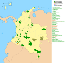
Protected areas
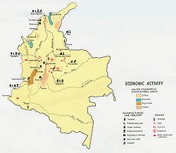
Natural resources
The natural resources of Colombia are varied and extensive with most of its territory and oceans still unexplored. Colombia has one of the largest coal open mine pits in the world in the region of CerrejonCerrejón
Cerrejón is a coal mine located in the Guajira department in the north of Colombia. It is the largest mining operation in Colombia and among the largest open-pit coal mines in the world. The legal entity managing the Cerrejón operation is known as Carbones del Cerrejón Ltd...
in the Guajira Peninsula
Guajira Peninsula
Guajira Peninsula , is a peninsula in northern Colombia and northwestern Venezuela in the Caribbean Sea...
. It also has oil rigs and natural gas extraction in the eastern plains. Colombia is the main producer of emerald
Emerald
Emerald is a variety of the mineral beryl colored green by trace amounts of chromium and sometimes vanadium. Beryl has a hardness of 7.5–8 on the 10 point Mohs scale of mineral hardness...
s and an important participant in gold, silver, iron, salt, platinum and uranium extraction.
Environmental issues

Extreme points
Highest points:Snowfields and glaciers in Colombia are limited to the highest peaks and ranges in the Cordillera Central and Cordillera Oriental and above the 4,700-meter elevation on the Sierra Nevada de Santa Marta. The total area of snowfields and glaciers was estimated to be about 104 square kilometers in the early 1970s.
Historical, geographical, and pictorial records point toward a consistent and progressive depletion of ice-and-snow masses in the Colombian Andes since the end of the "Little Ice Age" in the late 1800s. Many glaciers have disappeared during the 20th century, and others are expected to disappear in the coming decades.
Facts
Land boundaries:total: 6,004 km
Coastline:
3,208 km (Caribbean Sea 1,760 km, North Pacific Ocean 1,448 km)
Climate:
tropical along coast and eastern plains; cooler in highlands
Terrain:
flat coastal lowlands, central highlands, high Andes Mountains, eastern lowland plains
Elevation extremes:
lowest point: Pacific Ocean 0 m
highest point: Pico Cristobal Colon 5,975 m
note: nearby Pico Simon Bolivar also has the same elevation
Natural resources:
petroleum, natural gas, coal, iron ore, nickel, gold, copper, emeralds, hydropower
Land use:
arable land: 2.42%
permanent crops: 1.67%
other: 95.91% (2001)
Irrigated land:
8,500 km² (1998 est.)
Natural hazards:
highlands subject to volcanic eruptions; occasional earthquakes; periodic droughts
Environment - international agreements:
party to: Antarctic Treaty, Biodiversity, Climate Change, Climate Change-Kyoto Protocol, Desertification, Endangered Species, Hazardous Wastes, Marine Life Conservation, Ozone Layer Protection, Ship Pollution, Tropical Timber 83, Tropical Timber 94, Wetlands
signed, but not ratified: Law of the Sea
Hydrology
Colombia has four main drainage systems: the Pacific drain, the Caribbean drain, the Orinoco Basin and the Amazon Basin.The Orinoco
Orinoco
The Orinoco is one of the longest rivers in South America at . Its drainage basin, sometimes called the Orinoquia, covers , with 76.3% of it in Venezuela and the remainder in Colombia...
and Amazon
Amazon River
The Amazon of South America is the second longest river in the world and by far the largest by waterflow with an average discharge greater than the next seven largest rivers combined...
Rivers mark limits with Colombia to Venezuela
Venezuela
Venezuela , officially called the Bolivarian Republic of Venezuela , is a tropical country on the northern coast of South America. It borders Colombia to the west, Guyana to the east, and Brazil to the south...
and Peru
Peru
Peru , officially the Republic of Peru , is a country in western South America. It is bordered on the north by Ecuador and Colombia, on the east by Brazil, on the southeast by Bolivia, on the south by Chile, and on the west by the Pacific Ocean....
respectively.
| Caribbean Drain | Pacifice Drain | Orinoco Basin | Amazon Basin |
|---|---|---|---|
Rivers confined to Colombia |
|||
|
Baudo -animal species:*Baudó Oropendola, bird species*Baudo Guan, bird species... Patia Patia is a genus of butterflies in the subfamily Dismorphiinae. They are native to the Americas.-Species:* Patia cordillera * Patia orise * Patia rhetes... San Juan River (Colombia) San Juan River is an important river of Colombia. It quoted source is in the Cordillera Occidental and has a length of 380 km... |
Inírida Inírida may refer to:*Inírida, the capital city and a municipality of the Guainía Department in Colombia;*Inírida River, major tributary of the Guaviare River in the Guainía Department in Colombia;... Meta River The Meta River is formed in the Meta Department, Colombia by the confluence of the Humea, Guatiquía and Guayuriba rivers. It flows east-northeastward across the Llanos Orientales plains of Colombia through an ancient fault... Vichada River The Vichada River is a blackwater river in the country of Colombia, South America. It flows into the Orinoco River.The westward course of the Vichada is offset by an impact structure, called the Vichada Structure. The structure is most likely the largest impact structure in South America.... |
|
Rivers originated in Colombia |
|||
|
Arauca River The Arauca River rises in the Andes Mountains of north-central Colombia and ends at the Orinoco in Venezuela. For part of its run it is the boundary between Colombia and Venezuela... |
Putumayo River The Içá or Putumayo River is one of the tributaries of the Amazon River, west of and parallel to the Yapura. It forms part of Colombia's border with Ecuador, as well as most of the frontier with Peru... Vaupés River Vaupés River is a tributary of the Rio Negro in South America. It arises in the Guaviare Department of Colombia, flowing east through Guaviare and Vaupés Departments. It forms part of the international border between Colombia and the Amazonas state of Brazil. On the border it merges with the... |
|
Lakes
- Ciénaga Grande de Santa MartaCiénaga Grande de Santa MartaThe Ciénaga Grande de Santa Marta is the largest of the swampy marshes located between the Magdalena River and the Sierra Nevada de Santa Marta, weakly separated from the Caribbean Sea by a narrow strait....
- La Cocha Lagoon
- Lake TotaLake TotaLake Tota is the largest lake in Colombia, located in the east of Boyacá department. It has an area of 55 km² and a depth of 60 meters.The major town on the lake is Aquitania, located on its eastern side. Other nearby villages include Tota, Iza and Cuitiva. Lake Tota was an important religious...