

Geography of Cameroon
Encyclopedia

Papua New Guinea
Papua New Guinea , officially the Independent State of Papua New Guinea, is a country in Oceania, occupying the eastern half of the island of New Guinea and numerous offshore islands...
, and somewhat larger than the U.S. state
U.S. state
A U.S. state is any one of the 50 federated states of the United States of America that share sovereignty with the federal government. Because of this shared sovereignty, an American is a citizen both of the federal entity and of his or her state of domicile. Four states use the official title of...
of California
California
California is a state located on the West Coast of the United States. It is by far the most populous U.S. state, and the third-largest by land area...
. Cameroon's landmass is 181252 sq mi (469,440.5 km²), with 2317 sq mi (6,001 km²) of water.
The country is located in Central and West Africa, bordering the Bight of Biafra, between Equatorial Guinea and Nigeria.
Cameroon is sometimes described as "Africa in miniature" because it exhibits all the major climates and vegetation of the continent: mountains, desert, rain forest, savanna grassland, and ocean coastland. Cameroon can be divided into five geographic zones. These are distinguished by dominant physical, climatic, and vegetative features.
Natural regions

Cameroon's coastal plain extends 10 to 50 mi (16.1 to 80.5 km) inland from the Gulf of Guinea
Gulf of Guinea
The Gulf of Guinea is the northeasternmost part of the tropical Atlantic Ocean between Cape Lopez in Gabon, north and west to Cape Palmas in Liberia. The intersection of the Equator and Prime Meridian is in the gulf....
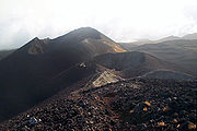
(part of the Atlantic Ocean) to the edge of a plateau. In the former western state, however, the mass of Mount Cameroon
Mount Cameroon
Mount Cameroon is an active volcano in Cameroon near the Gulf of Guinea. Mount Cameroon is also known as Cameroon Mountain or Fako or by its native name Mongo ma Ndemi ....
reaches almost to the sea. The plain is densely forested including areas of Central African mangroves
Central African mangroves
The Central African mangroves ecoregion consists of the largest area of mangrove swamp in Africa, located on the coasts of West Africa, mainly in Nigeria.-Location and description:...
especially around Douala
Douala
Douala is the largest city in Cameroon and the capital of Cameroon's Littoral Province. Home to Cameroon's largest port and its major international airport, Douala International Airport, it is the commercial capital of the country...
and in the estuary of the Cross River
Cross River (Nigeria)
Cross River is the main river in southeastern Nigeria and gives its name to Cross River State.It originates in Cameroon, where it takes the name of the Manyu River....
on the border with Nigeria
Nigeria
Nigeria , officially the Federal Republic of Nigeria, is a federal constitutional republic comprising 36 states and its Federal Capital Territory, Abuja. The country is located in West Africa and shares land borders with the Republic of Benin in the west, Chad and Cameroon in the east, and Niger in...
.
The low South Cameroon Plateau
South Cameroon Plateau
The South Cameroon Plateau or Southern Cameroon Plateau is the dominant geographical feature of Cameroon. The plateau lies south of the Adamawa Plateau and southeast of the Cameroon Range. It slopes south and west until giving way to the Cameroon coastal plain in the southwest and the Congo River...
, rising from the coastal plain and dominated by tropical rain forest, has an average elevation of 1500 to 2000 ft (457.2 to 609.6 m). It is less humid than the coast.
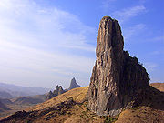
In western Cameroon is an irregular chain of mountains, hills, and plateaus that extend from Mt. Cameroon almost to Lake Chad
Lake Chad
Lake Chad is a historically large, shallow, endorheic lake in Africa, whose size has varied over the centuries. According to the Global Resource Information Database of the United Nations Environment Programme, it shrank as much as 95% from about 1963 to 1998; yet it also states that "the 2007 ...
at the northern tip of the country. This region includes the Bamenda, Bamiléké, and Mambilla highlands. It also contains some of the country's most fertile soils, notably around volcanic Mt. Cameroon. This area of tropical forest has been categorised by the World Wildlife Fund as the Cameroonian Highlands forests
Cameroonian Highlands forests
The Cameroonian Highlands forests are a montane tropical moist broadleaf forest ecoregion located on the range of mountains that runs inland from the Gulf of Guinea and forms the border between Cameroon and Nigeria...
ecoregion
Ecoregion
An ecoregion , sometimes called a bioregion, is an ecologically and geographically defined area that is smaller than an ecozone and larger than an ecosystem. Ecoregions cover relatively large areas of land or water, and contain characteristic, geographically distinct assemblages of natural...
with Mount Cameroon
Mount Cameroon and Bioko montane forests
The Mount Cameroon and Bioko montane forests ecoregion, of the tropical and subtropical moist broadleaf forests Biome, are in Afromontane habitats in Cameroon and Equatorial Guinea of Africa.- Setting :...
considered separately because as an active volcano it has a distinct environment from the other mountains.
From the forested southern plateau the land rises northward to the grassy, rugged Adamaoua (Adamawa) highlands. Stretching across Cameroon from the western mountain area, the Adamaoua forms a barrier between the north and south. Its average elevation is 3400 feet (1,036 m).
The northern savanna plain
Savanna
A savanna, or savannah, is a grassland ecosystem characterized by the trees being sufficiently small or widely spaced so that the canopy does not close. The open canopy allows sufficient light to reach the ground to support an unbroken herbaceous layer consisting primarily of C4 grasses.Some...
extends from the edge of the Adamaoua to Lake Chad. Its characteristic vegetation is scrub and grass. This is region of sparse rainfall and high median temperatures has been included as part of the East Sudanian savanna
East Sudanian savanna
The East Sudanian Savanna is a hot, dry, tropical savanna ecoregion of central Africa.-Location and description:This is the eastern half of the broad savanna belt which runs east and west across Africa, this section lying east of the Cameroon Highlands...
ecoregion.
Climate
The climate varies with terrain, from tropical along the coast to semiarid and hot in the north.Exceedingly hot and humid, the coastal belt includes some of the wettest places on earth. For example, Debundscha
Debundscha
Debundscha is a village in the Southwestern Region, of the republic of Cameroon. It is found at the foot of the Mount Cameroon,at its south western slope, directly facing the south Atlantic ocean on the Cameroon coast....
, at the base of Mt. Cameroon, has an average annual rainfall of 405 inches (10,287 mm).
Rivers
The country has four patterns of drainage. In the south, the principal rivers—the WouriWouri River
The Wouri is a river in Cameroon. The river is formed at the confluence of the rivers Nkam and Makombé, northeast of the city of Yabassi. The Wouri then flows about southeast to the Wouri estuary at Douala, the chief port and industrial city in the southwestern part of Cameroon on the Gulf of...
, Sanaga
Sanaga River
The Sanaga River is a river of South Province, Cameroon, Centre Province, Cameroon, and West Province, Cameroon. Its length is 890 kilometers.The Sanaga River forms a boundary between two tropical moist forest ecoregions...
, Nyong
Nyong River
The Nyong is a river in Cameroon. The river flows approximately 640 km to empty into the Gulf of Guinea.-Transport:The town of Mbalmayo, which has a railhead, lies on the north bank of this river. The towns of Akonolinga and Abong-Mbang also lie on it....
, and Ntem
Ntem River
The Ntem River is a border river in Cameroon, Equatorial Guinea and Gabon. It rises in Gabon, but flows into the Atlantic Ocean in Cameroon. A tributary continues along the border towards the east.- Towns :* Campo* Minvoul, Gabon...
—flow southwestward or westward directly into the Gulf of Guinea
Gulf of Guinea
The Gulf of Guinea is the northeasternmost part of the tropical Atlantic Ocean between Cape Lopez in Gabon, north and west to Cape Palmas in Liberia. The intersection of the Equator and Prime Meridian is in the gulf....
. The Dja
Dja River
The Dja River is a stream in west-central Africa. It forms part of Cameroon–Republic of Congo border and has a course of roughly 450 miles ....
and Kadeï
Kadéï River
The Kadéï River is a tributary of the Sangha River that flows through Cameroon and the Central African Republic. Its total drainage basin is 24,000 km². The river rises from the eastern Adamawa Plateau, southeast of Garoua-Boulaï |East Province]]. The Kadéï is swelled by two tributaries, the...
, however, drain southeastward into the Congo River
Congo River
The Congo River is a river in Africa, and is the deepest river in the world, with measured depths in excess of . It is the second largest river in the world by volume of water discharged, though it has only one-fifth the volume of the world's largest river, the Amazon...
. In northern Cameroon, the Benoué River
Benue River
The Benue River is the major tributary of the Niger River. The river is approximately 1,400 km long and is almost entirely navigable during the summer months...
(Benue) runs north and west, eventually into the Niger, while the Logone River flows northward into Lake Chad
Lake Chad
Lake Chad is a historically large, shallow, endorheic lake in Africa, whose size has varied over the centuries. According to the Global Resource Information Database of the United Nations Environment Programme, it shrank as much as 95% from about 1963 to 1998; yet it also states that "the 2007 ...
.
Only part of Lake Chad lies within Cameroon. The rest belongs to Chad
Chad
Chad , officially known as the Republic of Chad, is a landlocked country in Central Africa. It is bordered by Libya to the north, Sudan to the east, the Central African Republic to the south, Cameroon and Nigeria to the southwest, and Niger to the west...
, Nigeria, and Niger. The lake varies in size according to seasonal rainfall.
Some of the borders of Cameroon follow rivers, including the Aïna River
Aïna River
The Ayina is a tributary of the Ivindo that rises in Cameroon. Along the way it forms the border between Cameroon and Gabon and then the border between Gabon and the Republic of Congo...
and Ntem River
Ntem River
The Ntem River is a border river in Cameroon, Equatorial Guinea and Gabon. It rises in Gabon, but flows into the Atlantic Ocean in Cameroon. A tributary continues along the border towards the east.- Towns :* Campo* Minvoul, Gabon...
.
Data
Location:Central Africa
Africa
Africa is the world's second largest and second most populous continent, after Asia. At about 30.2 million km² including adjacent islands, it covers 6% of the Earth's total surface area and 20.4% of the total land area...
, bordering the Bight of Biafra, between Equatorial Guinea
Equatorial Guinea
Equatorial Guinea, officially the Republic of Equatorial Guinea where the capital Malabo is situated.Annobón is the southernmost island of Equatorial Guinea and is situated just south of the equator. Bioko island is the northernmost point of Equatorial Guinea. Between the two islands and to the...
and Nigeria
Nigeria
Nigeria , officially the Federal Republic of Nigeria, is a federal constitutional republic comprising 36 states and its Federal Capital Territory, Abuja. The country is located in West Africa and shares land borders with the Republic of Benin in the west, Chad and Cameroon in the east, and Niger in...
Geographic coordinates:
6°N 12°E
Map references:
Africa
Area:
total:
475,440 km²
land:
472,710 km²
water:
2,730 km²
Area - comparative:
slightly larger than California
California
California is a state located on the West Coast of the United States. It is by far the most populous U.S. state, and the third-largest by land area...
Land boundaries:
total:
4,591 km
border countries:
Central African Republic
Central African Republic
The Central African Republic , is a landlocked country in Central Africa. It borders Chad in the north, Sudan in the north east, South Sudan in the east, the Democratic Republic of the Congo and the Republic of the Congo in the south, and Cameroon in the west. The CAR covers a land area of about ,...
797 km, Chad
Chad
Chad , officially known as the Republic of Chad, is a landlocked country in Central Africa. It is bordered by Libya to the north, Sudan to the east, the Central African Republic to the south, Cameroon and Nigeria to the southwest, and Niger to the west...
1,094 km, Republic of the Congo
Republic of the Congo
The Republic of the Congo , sometimes known locally as Congo-Brazzaville, is a state in Central Africa. It is bordered by Gabon, Cameroon, the Central African Republic, the Democratic Republic of the Congo , the Angolan exclave province of Cabinda, and the Gulf of Guinea.The region was dominated by...
523 km, Equatorial Guinea
Equatorial Guinea
Equatorial Guinea, officially the Republic of Equatorial Guinea where the capital Malabo is situated.Annobón is the southernmost island of Equatorial Guinea and is situated just south of the equator. Bioko island is the northernmost point of Equatorial Guinea. Between the two islands and to the...
189 km, Gabon
Gabon
Gabon , officially the Gabonese Republic is a state in west central Africa sharing borders with Equatorial Guinea to the northwest, Cameroon to the north, and with the Republic of the Congo curving around the east and south. The Gulf of Guinea, an arm of the Atlantic Ocean is to the west...
298 km, Nigeria 1,690 km
Coastline:
402 km
Maritime claims:
territorial sea:
50 nmi (92.6 km; 57.5 mi)
Terrain:
diverse, with coastal plain
Plain
In geography, a plain is land with relatively low relief, that is flat or gently rolling. Prairies and steppes are types of plains, and the archetype for a plain is often thought of as a grassland, but plains in their natural state may also be covered in shrublands, woodland and forest, or...
in southwest, dissected plateau
Plateau
In geology and earth science, a plateau , also called a high plain or tableland, is an area of highland, usually consisting of relatively flat terrain. A highly eroded plateau is called a dissected plateau...
in center, mountain
Mountain
Image:Himalaya_annotated.jpg|thumb|right|The Himalayan mountain range with Mount Everestrect 58 14 160 49 Chomo Lonzorect 200 28 335 52 Makalurect 378 24 566 45 Mount Everestrect 188 581 920 656 Tibetan Plateaurect 250 406 340 427 Rong River...
s in west, plains in north
Elevation extremes:
lowest point:
Atlantic Ocean
Atlantic Ocean
The Atlantic Ocean is the second-largest of the world's oceanic divisions. With a total area of about , it covers approximately 20% of the Earth's surface and about 26% of its water surface area...
0 m
highest point:
Fako (on. Mt. Cameroon) 4,095 m
Natural resources:
petroleum
Petroleum
Petroleum or crude oil is a naturally occurring, flammable liquid consisting of a complex mixture of hydrocarbons of various molecular weights and other liquid organic compounds, that are found in geologic formations beneath the Earth's surface. Petroleum is recovered mostly through oil drilling...
, bauxite
Bauxite
Bauxite is an aluminium ore and is the main source of aluminium. This form of rock consists mostly of the minerals gibbsite Al3, boehmite γ-AlO, and diaspore α-AlO, in a mixture with the two iron oxides goethite and hematite, the clay mineral kaolinite, and small amounts of anatase TiO2...
, iron ore, timber
Timber
Timber may refer to:* Timber, a term common in the United Kingdom and Australia for wood materials * Timber, Oregon, an unincorporated community in the U.S...
, hydropower
Hydropower
Hydropower, hydraulic power, hydrokinetic power or water power is power that is derived from the force or energy of falling water, which may be harnessed for useful purposes. Since ancient times, hydropower has been used for irrigation and the operation of various mechanical devices, such as...
Land use:
arable land:
12.54%
permanent crops:
2.52%
other:
84.94% (2005)
Irrigated land:
260 km² (2003)
285.5 km³ (2003)
Freshwater withdrawal (domestic/industrial/agricultural):
total:
0.99 km³/yr (18%/8%/74%)
per capita:
61 m³/yr (2000)
Natural hazards:
Recent limnic eruption
Limnic eruption
A limnic eruption, also referred to as a lake overturn, is a rare type of natural disaster in which carbon dioxide suddenly erupts from deep lake water, suffocating wildlife, livestock and humans. Such an eruption may also cause tsunamis in the lake as the rising CO2 displaces water. Scientists...
s with release of carbon dioxide
Carbon dioxide
Carbon dioxide is a naturally occurring chemical compound composed of two oxygen atoms covalently bonded to a single carbon atom...
:
- from Lake MonounLake MonounLake Monoun is a lake in West Province, Cameroon, that lies in the Oku Volcanic Field . On August 15, 1984, the lake exploded in a limnic eruption, which resulted in the release of a large amount of carbon dioxide that killed 37 people. At first, the cause of the deaths was a mystery, and...
, August 15, 1984, killing 37 - from Lake NyosLake NyosLake Nyos is a crater lake in the Northwest Region of Cameroon, located about northwest of Yaoundé. Nyos is a deep lake high on the flank of an inactive volcano in the Oku volcanic plain along the Cameroon line of volcanic activity...
, August 21, 1986, killing as many as 1800
Environment - current issues:
water-borne diseases are prevalent; deforestation
Deforestation
Deforestation is the removal of a forest or stand of trees where the land is thereafter converted to a nonforest use. Examples of deforestation include conversion of forestland to farms, ranches, or urban use....
; overgrazing
Overgrazing
Overgrazing occurs when plants are exposed to intensive grazing for extended periods of time, or without sufficient recovery periods. It can be caused by either livestock in poorly managed agricultural applications, or by overpopulations of native or non-native wild animals.Overgrazing reduces the...
; desertification
Desertification
Desertification is the degradation of land in drylands. Caused by a variety of factors, such as climate change and human activities, desertification is one of the most significant global environmental problems.-Definitions:...
; poaching
Poaching
Poaching is the illegal taking of wild plants or animals contrary to local and international conservation and wildlife management laws. Violations of hunting laws and regulations are normally punishable by law and, collectively, such violations are known as poaching.It may be illegal and in...
; overfishing
Overfishing
Overfishing occurs when fishing activities reduce fish stocks below an acceptable level. This can occur in any body of water from a pond to the oceans....
Environment - international agreements:
party to:
Biodiversity
Biodiversity
Biodiversity is the degree of variation of life forms within a given ecosystem, biome, or an entire planet. Biodiversity is a measure of the health of ecosystems. Biodiversity is in part a function of climate. In terrestrial habitats, tropical regions are typically rich whereas polar regions...
, Climate Change
United Nations Framework Convention on Climate Change
The United Nations Framework Convention on Climate Change is an international environmental treaty produced at the United Nations Conference on Environment and Development , informally known as the Earth Summit, held in Rio de Janeiro from June 3 to 14, 1992...
, Desertification, Endangered Species
Endangered species
An endangered species is a population of organisms which is at risk of becoming extinct because it is either few in numbers, or threatened by changing environmental or predation parameters...
, Law of the Sea
Law of the sea
Law of the sea may refer to:* United Nations Convention on the Law of the Sea* Admiralty law* The Custom of the Sea...
, Ozone Layer Protection, Tropical Timber 83, Tropical Timber 94
signed, but not ratified:
Nuclear Test Ban
Geography - note:
sometimes referred to as 'the hinge of Africa;' throughout the country there are areas of thermal springs and indications of current or prior volcanic activity; Mount Cameroon, the highest mountain in Sub-Saharan west Africa, is an active volcano
Extreme points
This is a list of the extreme points of CameroonCameroon
Cameroon, officially the Republic of Cameroon , is a country in west Central Africa. It is bordered by Nigeria to the west; Chad to the northeast; the Central African Republic to the east; and Equatorial Guinea, Gabon, and the Republic of the Congo to the south. Cameroon's coastline lies on the...
, the points that are farther north, south, east or west than any other location.
- Northernmost point - unnamed peninsulaPeninsulaA peninsula is a piece of land that is bordered by water on three sides but connected to mainland. In many Germanic and Celtic languages and also in Baltic, Slavic and Hungarian, peninsulas are called "half-islands"....
jutting into lake ChadLake ChadLake Chad is a historically large, shallow, endorheic lake in Africa, whose size has varied over the centuries. According to the Global Resource Information Database of the United Nations Environment Programme, it shrank as much as 95% from about 1963 to 1998; yet it also states that "the 2007 ...
, Far NorthFar North ProvinceThe Far North Region , also known as the Extreme North Region , is the northernmost constituent province of the Republic of Cameroon. It borders the North Region to the south, Chad to the east, and Nigeria to the west. The capital is Maroua.The province is one of Cameroon's most culturally diverse...
province - Easternmost point - unnamed location on the border with the Republic of Congo in the Sangha riverSangha RiverThe Sangha River, a river in central Africa, is a tributary of the Congo River, which it joins at . Formed by the merging of the Mambéré River into the Kadéï River at Nola , the Sangha flows through the Central African Republic, along the border of Cameroon, and through the Republic of Congo.Its...
opposite the Congolese town of BomassaBomassaBomassa is a town in the northern Republic of Congo, lying on the Sanga River and the border with the Central African Republic. It is known for its local rainforests, home to a wide variety of large mammals. There have been repeated calls for its immediate area to be designated a national park....
, East region - Southernmost point - unnamed headland at the confluenceConfluenceConfluence, in geography, describes the meeting of two or more bodies of water.Confluence may also refer to:* Confluence , a property of term rewriting systems...
on the Sangha riverSangha RiverThe Sangha River, a river in central Africa, is a tributary of the Congo River, which it joins at . Formed by the merging of the Mambéré River into the Kadéï River at Nola , the Sangha flows through the Central African Republic, along the border of Cameroon, and through the Republic of Congo.Its...
and the Ngoko river immediately north of the Congolese town of OuessoOuéssoOuesso is a town in the northern Republic of the Congo, lying on the Sangha River and surrounded by rainforest. It is linked by ferry with Brazzaville and is known for the pygmy people who live nearby...
, East region - Westernmost point - unnamed point on Akwabana island, Southwest region