
Geography of California
Encyclopedia
Covering an area of 163696 sq mi (423,970.7 km²), California is geographically diverse. The Sierra Nevada Mountains, the fertile farmlands of the Central Valley, and the arid Mojave Desert
of the south are some of the major geographic features of this U.S. state
. It is home to some of the world's most exceptional trees: the tallest (coast redwood), most massive (Giant Sequoia), and oldest (bristlecone pine
). It is also home to both the highest (Mt. Whitney) and lowest (Death Valley
) points in the 48 contiguous states.
The state is generally divided into Northern
and Southern California
, although the boundary between the two is not well defined. San Francisco is decidedly a Northern California city and Los Angeles likewise a Southern California one, but areas in between do not often share their confidence in geographic identity. The US Geological Survey defines the geographic center of the state at a point near North Fork, California
.
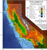
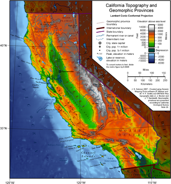
Earth scientists typically divide the state into eleven distinct geomorphic provinces with clearly defined boundaries. They are, from north to south, the Klamath Mountains
, the Cascade Range
, the Modoc Plateau
, the Basin and Range
, the Coast Ranges, the Central Valley, the Sierra Nevada, the Transverse Ranges
, the Mojave Desert
, the Peninsular Ranges
, and the Colorado Desert
. Here, the Los Angeles Basin
, the Channel Islands, and the Pacific Ocean
are treated as distinct regions.
are a mountain range in northwest California and southwest Oregon, the highest peak being Thompson Peak (2,744 m / 9,002 ft) in Trinity County, California
. They have a very varied geology, with substantial areas of serpentine and marble
, and a climate summers with limited rainfall. As a consequence of the geology, they have a unique flora including several endemic or near-endemic species, such as Lawson's Cypress (Chamaecyparis lawsoniana) and. Foxtail Pine
(Pinus balfouriana). Brewer's Spruce
(Picea breweriana) and Kalmiopsis
(Kalmiopsis leachiana) are relict species, remaining since the last ice age.
 The Cascade Range
is a mountainous region stretching from the Fraser River
in British Columbia
, Canada down to south of Lassen Peak
California. The Cascades (as they are called for short) are part of the Pacific Ring of Fire
, the ring of volcanoes around the Pacific Ocean. All of the known historic eruptions in the contiguous United States have been from Cascade volcanoes. Lassen Peak was the last Cascade volcano to erupt in California, from 1914 to 1921. Lassen is the most southerly active volcano of the Cascade chain.
This region is located in the northeastern section of the state bordering Oregon
and Nevada
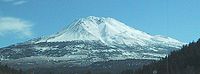
, mostly north of the Central Valley and the Sierra Nevada mountain range. The area is centered on Mount Shasta
, near the Trinity Alps
. Mount Shasta is a dormant volcano, but there is some evidence that it or Shastina
, a smaller companion, erupted in the 18th Century.
, an expanse of lava
flows that formed a million years ago and now lie at an altitude of 4000 to 5000 ft (1,219.2 to 1,524 m). The plateau has many cinder cone
s, juniper
flats, pine
forests, and seasonal lakes. The plateau lies between the Cascade Range to the west and the Warner Mountains
to the east. The Lost River
watershed drains the north part of the plateau, while southern watersheds either collect in basin reservoirs or flow into the large Big Sage Reservoir, and then into the Pit River
.
Nine percent of the plateau is protected as reserves or wilderness areas, such as the Modoc National Wildlife Refuge
. The plateau supports large herds of mule deer
(Odocoileus Hemionus), Rocky Mountain Elk
(Cervus Canadensis), and pronghorn antelope (Antilocapra Americana). Herds of wild horses and livestock grazing have altered the original high desert ecosystem of the plateau.
. The Basin and Range is a series of mountains and valleys (specifically horsts and graben
s), caused by the extension of the Earth's crust. One notable feature of the Basin and Range is Mono Lake
, which is the oldest lake in North America
. The Basin and Range also contains the Owens Valley
, the deepest valley in North America (more than 10,000 feet (3 km) deep, as measured from the top of Mount Whitney).
In the eastern part of the state, below the Sierra Nevada, there is a series dry lake beds that were filled with water during the last ice age (fed by ice melt from alpine glacier
s but never directly affected by glaciation; see pluvial
). Many of these lakes have extensive evaporite deposit
s that contain a variety of different salt
s. In fact, the salt sediments of many of these lake beds have been mined
for many years for various salts, most notably borax
(this is most famously true for Owens Lake
and Death Valley
).
In this province reside the White Mountains
, which are home to the oldest living thing in the world, the bristlecone pine
.
 To the west of the Central Valley lies the Coast Ranges
, including the Diablo Range
, just east of San Francisco
, and the Santa Cruz Mountains
, to the south of San Francisco. The Coast Ranges north of San Francisco become increasingly foggy and rainy. These mountains are noted for their coast redwoods, which live within the range of the coastal fog
, the tallest trees on Earth.
, a huge, fertile valley
between the coastal mountain ranges and the Sierra Nevada. The northern part of the Central Valley is called the Sacramento Valley
, after its main river, and the southern part is called the San Joaquin Valley
(icon), after its main river. The whole Central Valley is watered by mountain-fed rivers (notably the San Joaquin
, Kings
, and Sacramento
) that drain to the San Francisco Bay
system. The rivers are sufficiently large and deep that several inland cities, notably Stockton, California
, and Sacramento, California
are seaports.
The southern tip of the valley has interior drainage and thus is not technically part of the valley at all. Tulare Lake
, once 570 square miles (1,476 square kilometers) and now dry and covered with agricultural fields, once filled much of the area.
at 14,505 feet (4,421 m), lies within the Sierra Nevada. The topography of the Sierra is shaped by uplift and glacial action.
The Sierra has 200–250 sunny days each year, warm summers, fierce winters, and varied terrain, a rare combination of rugged variety and pleasant weather. The famous Yosemite Valley
lies in the Central Sierra. The large, deep freshwater Lake Tahoe
lies to the North of Yosemite. The Sierra is also home to the Giant Sequoia, the most massive trees on Earth.
The most famous hiking and horse-packing trail in the Sierra is the John Muir Trail
, which goes from the top of Mt. Whitney to Yosemite valley, and which is part of the Pacific Crest Trail
that goes from Mexico
to Canada
. The three major national parks in this province are Yosemite National Park
, Kings Canyon National Park
, and Sequoia National Park
.
 Southern California
is separated from the rest of the state by the east-west trending Transverse Ranges
, including the Tehachapi
, which separate the Central Valley from the Mojave Desert
. Urban Southern California intersperses the valleys between the Santa Susana Mountains
, Santa Monica Mountains
and San Gabriel Mountains
, which range from the Pacific Coast, eastward over 100 miles (160.9 km), to the San Bernardino Mountains
, north of San Bernardino
. The highest point of the range is Mount San Gorgonio at 11499 feet (3,504.9 m). The San Gabriel Mountains have Mount Wilson observatory
, where the redshift
was discovered in the 1920s.
The Transverse Ranges include a series of east–west trending mountain ranges that extend from Point Conception at the western tip of Santa Barbara County, eastward (and a bit south) to the east end of the San Jacinto Mountains in western Riverside County. The Santa Ynez Mountains make up the westernmost ranges, extending from Point Conception to the Ventura River just west-northwest of Ojai, in Ventura County. Pine Mountain Ridge, Nordhoff Ridge–Topatopa Mountains, Rincon Peak–Red Mountain, Sulphur Mountain, Santa Paula Ridge, South Mountain–Oat Mountain
–Santa Susana Mountains, Simi Hills, Conejo Mountains–Santa Monica Mountains are all part of the Western Transverse Ranges, in Ventura and western Los Angeles Counties.
The Liebre Mountains occupy the northwest corner of Los Angeles County, and represent a northwestern extension of the San Gabriel Mountains, both on the Pacific Plate side of the San Andreas Fault. The fault divides the San Gabriel Mountains from the San Bernardino Mountains further to the east in San Bernardino County.
It is possible to surf
in the Pacific Ocean
and ski
on a mountain during the same winter day in Southern California
.
 For the last 15 million years, the Los Angeles
, San Gabriel
, and Santa Ana River
s have deposited sediment from the Transverse Ranges along the southern coast of California. That sediment has formed the large, flat expanse of land known as the Los Angeles Basin
, on which lives most of the population of Los Angeles and Orange
Counties.
At its deepest point, near where the Los Angeles River meets the Rio Hondo
, the sediment forming the basin is 6 miles (10 km) deep. The fact that so much sediment, which is naturally less stable than other geologic formations, underlies Los Angeles and its environs is one of the reasons earthquake
s are such a danger to the metropolitan area.
 There are harsh desert
s in the Southeast of California. These deserts are caused by a combination of the cold offshore current, which limits evaporation, and the rain shadow
of the mountains. The prevailing winds blow from the ocean inland. When the air passes over the mountains, adiabatic cooling causes most water in the air to rain on the mountains. When the air returns to sea level on the other side of the mountains, it recompresses, warms and dries, parching the deserts. When the wind blows from inland, the resulting hot dry foehn winds are called the Santa Ana Winds.
The Mojave Desert
is bounded by the peninsular Tehachapi Mountains on the Northwest, together with the San Gabriel and the San Bernardino Mountains on the Southwest. These Western boundaries are quite distinct, forming the dominant pie-slice shaped Antelope Valley in Southern California. The outlines of this valley are caused by the two largest faults in California: the San Andreas
and the Garlock
. The Mojave Desert extends Eastward into the State of Nevada
. The Mojave Desert receives less than 6 inches (150 mm) of rain a year and is generally between 3,000 and 6,000 feet (1,000 and 2,000 m) of elevation. Areas such as the Antelope Valley desert which is a high desert received snow each year, in the past it could snow 2-3 times a year; however, recently snow level has declined significantly to once a year or less. Most of the towns and cities in the California portion of the Mojave are relatively small, except for Palmdale
and Lancaster
. However, some are quite famous like Barstow
, a popular stop on the famous U.S. Route 66
. The Mojave Desert also contains the lowest, hottest place in the Americas
: Death Valley
, where temperature normally approaches 120 °F (49 °C) in late July and early August.
, which are East of San Diego
and continue into Baja California
(Mexico
) in the Sierra San Pedro Martir
. The Peninsular Ranges contain the Laguna Mountains
, the San Jacinto Mountains
, the Santa Rosa Mountains
, the Santa Ana Mountains
and the Palomar Mountain Range
, notable for its famous Palomar observatory. San Jacinto Peak
's eastern shoulder has a cable tram that runs from the desert floor to nearly the top of the mountain where riders can set off hiking
or go cross-country skiing
.
and Sonoran Desert
s, which extend into Arizona
and Mexico.
The ground elevation is generally lower and in some areas was compressed downward, therefore the eastern Coachella
and Imperial Valley
s north of the U.S.-Mexican border are below sea level, the lowest community in the U.S. is Calipatria, California
at 160 feet (48.8 m) below sea level.
One feature of the desert is the Salton Sea
, an inland lake that was formed in 1905 when a swollen Colorado River breached a canal
near the U.S.-Mexico border and flowed into the Salton Sink
(Salton Basin) for almost two years. Today, the Salton Sea, a new version of historic Lake Cahuilla
, remains as California's largest lake.
are a group of island
s off the coast
of Southern California. They are divided into two groups, the Northern Channel Islands and the Southern Channel Islands. There are eight islands total:
Four of the islands are located in Santa Barbara County
, two are located in Ventura County
, and two are located in Los Angeles County
. The islands have relatively few people. The only island with a sizable settlement is Santa Catalina
, with its towns of Avalon
and Two Harbors
. The islands of Anacapa, San Miguel, Santa Barbara, Santa Cruz, and Santa Rosa make up the Channel Islands National Park
. There is also a marine sanctuary in the islands, the Channel Islands National Marine Sanctuary
. The Channel Islands, and in particular San Nicolas Island, are famous for the Lost Woman of San Nicolas, or Juana Maria
. This woman was the main character in the book Island of the Blue Dolphins
by Scott O’Dell.
The Palos Verdes
Peninsula has the same geologic origins as the Channel Islands. Once an island north of Santa Catalina, Palos Verdes is today connected to the mainland. Over millions of years, sediment from nearby mountains extended the shoreline of the Los Angeles Basin until it reached Palos Verdes.
lies to the west of California. Sea temperatures rarely exceed 65 °F (18 °C), even in summer, because of up-welling
deep waters with dissolved nutrients. Therefore, most sea life in and around California more closely resembles Arctic, rather than tropical, biotope
s. The sea off California is remarkably fertile, a murky green filled with fish, rather than the clear dead blue of most tropical seas. Before 1930, there was an extremely valuable sardine
(herring
) fishery off Monterey
, but this was depleted, an event later famous as the background to John Steinbeck
's Cannery Row
.
s occur due to faults that run the length of the Pacific coast, the largest being the San Andreas
. Major historical earthquakes include:
Coastal cities are vulnerable to tsunami
s from locally generated earthquakes as well as those elsewhere in the Pacific Ring of Fire
. The Great Chilean Earthquake
tsunami (1960) killed one person and caused $500,000 to $1,000,000 dollars of damage in Los Angeles
, damaged harbors in many coastal cities, and flooded streets in Crescent City
. Waves from the Alaskan Good Friday Earthquake
of 1964 killed twelve people in Crescent City and caused damage as far south as Los Angeles.
California is also home to several volcano
es, including Lassen Peak
, which erupted in 1914 and 1921, and Mount Shasta
.
is approached from the Gulf of California
the land appears to the west. It is expected, through the motions of plate tectonics
that the sea floor spreading now acting in the Gulf of California (also known as the Sea of Cortez) will eventually extend through Southern California and along the San Andreas fault to below San Francisco, finally forming a long island in less than 150 million years. (For comparison, this is also the approximate age of the Atlantic Ocean
.) Predictions suggest that this island will eventually collide with Alaska
after an additional 100 million years.
's climate varies widely, from arid
to subarctic
, depending on latitude
, elevation
, and proximity to the coast. Coastal and Southern parts of the state have a Mediterranean climate
, with somewhat rainy winters and dry summers. The influence of the ocean
generally moderates temperature extremes, creating warmer winters and substantially cooler summers, especially along the coastal areas.
The state is subject to coastal storms during the winter. Eastern California is subject to summertime thunderstorms caused by the North American monsoon
. Dry weather during the rest of the year produces conditions favorable to wildfire
s. California hurricanes occur less frequently than their counterparts on the Atlantic Ocean
. Higher elevations experience snowstorms in the winter months.
Flood
s are occasionally caused by heavy rain, storms, and snowmelt. Steep slopes and unstable soil make certain locations vulnerable to landslides in wet weather or during earthquakes.
Mojave Desert
The Mojave Desert occupies a significant portion of southeastern California and smaller parts of central California, southern Nevada, southwestern Utah and northwestern Arizona, in the United States...
of the south are some of the major geographic features of this U.S. state
U.S. state
A U.S. state is any one of the 50 federated states of the United States of America that share sovereignty with the federal government. Because of this shared sovereignty, an American is a citizen both of the federal entity and of his or her state of domicile. Four states use the official title of...
. It is home to some of the world's most exceptional trees: the tallest (coast redwood), most massive (Giant Sequoia), and oldest (bristlecone pine
Bristlecone pine
The bristlecone pines are a small group of pine trees that are thought to reach an age far greater than that of any other single living organism known, up to nearly 5,000 years....
). It is also home to both the highest (Mt. Whitney) and lowest (Death Valley
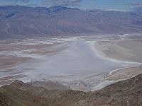
Death Valley
Death Valley is a desert valley located in Eastern California. Situated within the Mojave Desert, it features the lowest, driest, and hottest locations in North America. Badwater, a basin located in Death Valley, is the specific location of the lowest elevation in North America at 282 feet below...
) points in the 48 contiguous states.
The state is generally divided into Northern
Northern California
Northern California is the northern portion of the U.S. state of California. The San Francisco Bay Area , and Sacramento as well as its metropolitan area are the main population centers...
and Southern California
Southern California
Southern California is a megaregion, or megapolitan area, in the southern area of the U.S. state of California. Large urban areas include Greater Los Angeles and Greater San Diego. The urban area stretches along the coast from Ventura through the Southland and Inland Empire to San Diego...
, although the boundary between the two is not well defined. San Francisco is decidedly a Northern California city and Los Angeles likewise a Southern California one, but areas in between do not often share their confidence in geographic identity. The US Geological Survey defines the geographic center of the state at a point near North Fork, California
North Fork, California
North Fork is an unincorporated community in Madera County, California. It is located east of Raymond, at an elevation of 2638 feet .It is miles south east of Bass Lake and from Oakhurst. North Fork is also home of the Mono Indian Museum and the starting point of the Sierra scenic byway...
.
Earth scientists typically divide the state into eleven distinct geomorphic provinces with clearly defined boundaries. They are, from north to south, the Klamath Mountains
Klamath Mountains
The Klamath Mountains, which include the Siskiyou, Marble, Scott, Trinity, Trinity Alps, Salmon, and northern Yolla-Bolly Mountains, are a rugged lightly populated mountain range in northwest California and southwest Oregon in the United States...
, the Cascade Range
Cascade Range
The Cascade Range is a major mountain range of western North America, extending from southern British Columbia through Washington and Oregon to Northern California. It includes both non-volcanic mountains, such as the North Cascades, and the notable volcanoes known as the High Cascades...
, the Modoc Plateau
Modoc Plateau
The Modoc Plateau lies in the northeast corner of California as well as parts of Oregon and Nevada. It is a mile-high expanse of lava flows with cinder cones, juniper flats, pine forests, and seasonal lakes. The plateau is thought to have been formed approximately 25 million years ago...
, the Basin and Range
Basin and Range
The Basin and Range Province is a vast physiographic region defined by a unique topographic expression. Basin and Range topography is characterized by abrupt changes in elevation, alternating between narrow faulted mountain chains and flat arid valleys or basins...
, the Coast Ranges, the Central Valley, the Sierra Nevada, the Transverse Ranges
Transverse Ranges
The Transverse Ranges are a group of mountain ranges of southern California, in the Pacific Coast Ranges physiographic region that runs along the Pacific coast from Alaska to Mexico in North America. The Transverse Ranges begin at the southern end of the California Coast Ranges and lie between...
, the Mojave Desert
Mojave Desert
The Mojave Desert occupies a significant portion of southeastern California and smaller parts of central California, southern Nevada, southwestern Utah and northwestern Arizona, in the United States...
, the Peninsular Ranges
Peninsular Ranges
The Peninsular Ranges are a group of mountain ranges, in the Pacific Coast Ranges, which stretch from southern California in the United States to the southern tip of Mexico's Baja California peninsula; they are part of the North American Coast Ranges that run along the Pacific coast from Alaska...
, and the Colorado Desert
Colorado Desert
California's Colorado Desert is a part of the larger Sonoran Desert, which extends across southwest North America. The Colorado Desert region encompasses approximately , reaching from the Mexican border in the south to the higher-elevation Mojave Desert in the north and from the Colorado River in...
. Here, the Los Angeles Basin
Los Angeles Basin
The Los Angeles Basin is the coastal sediment-filled plain located between the Peninsular and Transverse ranges in southern California in the United States containing the central part of the city of Los Angeles as well as its southern and southeastern suburbs...
, the Channel Islands, and the Pacific Ocean
Pacific Ocean
The Pacific Ocean is the largest of the Earth's oceanic divisions. It extends from the Arctic in the north to the Southern Ocean in the south, bounded by Asia and Australia in the west, and the Americas in the east.At 165.2 million square kilometres in area, this largest division of the World...
are treated as distinct regions.
Northern California
Klamath Mountains
The Klamath MountainsKlamath Mountains
The Klamath Mountains, which include the Siskiyou, Marble, Scott, Trinity, Trinity Alps, Salmon, and northern Yolla-Bolly Mountains, are a rugged lightly populated mountain range in northwest California and southwest Oregon in the United States...
are a mountain range in northwest California and southwest Oregon, the highest peak being Thompson Peak (2,744 m / 9,002 ft) in Trinity County, California
Trinity County, California
Trinity County is a large, rugged and mountainous, heavily forested county located in the northwestern portion of the U.S. state of California, along the Trinity River and within the Salmon/Klamath Mountains. It covers an area of over two million acres , and as of the 2010 census its population...
. They have a very varied geology, with substantial areas of serpentine and marble
Marble
Marble is a metamorphic rock composed of recrystallized carbonate minerals, most commonly calcite or dolomite.Geologists use the term "marble" to refer to metamorphosed limestone; however stonemasons use the term more broadly to encompass unmetamorphosed limestone.Marble is commonly used for...
, and a climate summers with limited rainfall. As a consequence of the geology, they have a unique flora including several endemic or near-endemic species, such as Lawson's Cypress (Chamaecyparis lawsoniana) and. Foxtail Pine
Foxtail Pine
The Foxtail Pine is a rare pine that is endemic to California, United States, where it is found in two areas with a separate subspecies in each, the typical subsp. balfouriana in the Klamath Mountains, and subsp. austrina in the southern Sierra Nevada.-Description:Foxtail Pine is a tree to tall,...
(Pinus balfouriana). Brewer's Spruce
Brewer's Spruce
Picea breweriana is a species of spruce native to western North America, where it is one of the rarest on the continent, endemic to the Klamath Mountains of southwest Oregon and northwest California...
(Picea breweriana) and Kalmiopsis
Kalmiopsis
Kalmiopsis is a small genus of flowering plants in the heath family. It contains two species endemic to Oregon in the United States. This was a monotypic genus containing only Kalmiopsis leachiana until 2007, when a form of it was elevated to species status, Kalmiopsis fragrans....
(Kalmiopsis leachiana) are relict species, remaining since the last ice age.
Cascade Range
Cascade Range
The Cascade Range is a major mountain range of western North America, extending from southern British Columbia through Washington and Oregon to Northern California. It includes both non-volcanic mountains, such as the North Cascades, and the notable volcanoes known as the High Cascades...
is a mountainous region stretching from the Fraser River
Fraser River
The Fraser River is the longest river within British Columbia, Canada, rising at Fraser Pass near Mount Robson in the Rocky Mountains and flowing for , into the Strait of Georgia at the city of Vancouver. It is the tenth longest river in Canada...
in British Columbia
British Columbia
British Columbia is the westernmost of Canada's provinces and is known for its natural beauty, as reflected in its Latin motto, Splendor sine occasu . Its name was chosen by Queen Victoria in 1858...
, Canada down to south of Lassen Peak
Lassen Peak
Lassen Peak is the southernmost active volcano in the Cascade Range. It is part of the Cascade Volcanic Arc which is an arc that stretches from northern California to southwestern British Columbia...
California. The Cascades (as they are called for short) are part of the Pacific Ring of Fire
Pacific Ring of Fire
The Pacific Ring of Fire is an area where large numbers of earthquakes and volcanic eruptions occur in the basin of the Pacific Ocean. In a horseshoe shape, it is associated with a nearly continuous series of oceanic trenches, volcanic arcs, and volcanic belts and/or plate movements...
, the ring of volcanoes around the Pacific Ocean. All of the known historic eruptions in the contiguous United States have been from Cascade volcanoes. Lassen Peak was the last Cascade volcano to erupt in California, from 1914 to 1921. Lassen is the most southerly active volcano of the Cascade chain.
This region is located in the northeastern section of the state bordering Oregon
Oregon
Oregon is a state in the Pacific Northwest region of the United States. It is located on the Pacific coast, with Washington to the north, California to the south, Nevada on the southeast and Idaho to the east. The Columbia and Snake rivers delineate much of Oregon's northern and eastern...
and Nevada
Nevada
Nevada is a state in the western, mountain west, and southwestern regions of the United States. With an area of and a population of about 2.7 million, it is the 7th-largest and 35th-most populous state. Over two-thirds of Nevada's people live in the Las Vegas metropolitan area, which contains its...
, mostly north of the Central Valley and the Sierra Nevada mountain range. The area is centered on Mount Shasta
Mount Shasta
Mount Shasta is located at the southern end of the Cascade Range in Siskiyou County, California and at is the second highest peak in the Cascades and the fifth highest in California...
, near the Trinity Alps
Trinity Alps
The Trinity Alps are mountains in Northern California, in the Pacific Coast Ranges physiographic region, located to the northwest of Redding. Elevations there range from to at Thompson Peak. The Trinity Alps Wilderness covers , making it the second largest wilderness area in California...
. Mount Shasta is a dormant volcano, but there is some evidence that it or Shastina
Shastina
Shastina is the highest satellite cone of Mount Shasta, and one of four overlapping volcanic cones which together form the most voluminous stratovolcano in the Cascade Range. At , Shastina is taller than Mount Adams and would rank as the third highest volcano in the Cascades behind Mount Rainier...
, a smaller companion, erupted in the 18th Century.
Modoc Plateau
In the northeast corner of the state lies the Modoc PlateauModoc Plateau
The Modoc Plateau lies in the northeast corner of California as well as parts of Oregon and Nevada. It is a mile-high expanse of lava flows with cinder cones, juniper flats, pine forests, and seasonal lakes. The plateau is thought to have been formed approximately 25 million years ago...
, an expanse of lava
Lava
Lava refers both to molten rock expelled by a volcano during an eruption and the resulting rock after solidification and cooling. This molten rock is formed in the interior of some planets, including Earth, and some of their satellites. When first erupted from a volcanic vent, lava is a liquid at...
flows that formed a million years ago and now lie at an altitude of 4000 to 5000 ft (1,219.2 to 1,524 m). The plateau has many cinder cone
Cinder cone
According to the , Cinder Cone is the proper name of 1 cinder cone in Canada and 7 cinder cones in the United States:In Canada: Cinder Cone In the United States:...
s, juniper
Juniper
Junipers are coniferous plants in the genus Juniperus of the cypress family Cupressaceae. Depending on taxonomic viewpoint, there are between 50-67 species of juniper, widely distributed throughout the northern hemisphere, from the Arctic, south to tropical Africa in the Old World, and to the...
flats, pine
Pine
Pines are trees in the genus Pinus ,in the family Pinaceae. They make up the monotypic subfamily Pinoideae. There are about 115 species of pine, although different authorities accept between 105 and 125 species.-Etymology:...
forests, and seasonal lakes. The plateau lies between the Cascade Range to the west and the Warner Mountains
Warner Mountains
The Warner Mountains are an 85-mile-long mountain range running north-south through northeastern California and extending into southern Oregon in the United States...
to the east. The Lost River
Lost River (California)
Lost River begins and ends in a closed basin in northern California and southwestern Oregon in the United States. The river, long, flows in an arc from Clear Lake Reservoir in Modoc County, California, through Klamath County, Oregon to Tule Lake in Siskiyou County...
watershed drains the north part of the plateau, while southern watersheds either collect in basin reservoirs or flow into the large Big Sage Reservoir, and then into the Pit River
Pit River
The Pit River is a major river draining from northeastern California into the state's Central Valley. The Pit, the Klamath and the Columbia are the only three rivers in the U.S...
.
Nine percent of the plateau is protected as reserves or wilderness areas, such as the Modoc National Wildlife Refuge
Modoc National Wildlife Refuge
Modoc National Wildlife Refuge is home to more than 250 species of birds and a variety of other wildlife. Located in a high-altitude desert valley on the western edge of the Great Basin in Modoc County, California, the refuge is part of a large complex of mid-altitude wetlands and lakes in...
. The plateau supports large herds of mule deer
Mule Deer
The mule deer is a deer indigenous to western North America. The Mule Deer gets its name from its large mule-like ears. There are believed to be several subspecies, including the black-tailed deer...
(Odocoileus Hemionus), Rocky Mountain Elk
Rocky Mountain Elk
The Rocky Mountain Elk is a subspecies of elk found in the Rocky Mountains and adjacent ranges of Western North America. The winter ranges are most common in open forests and floodplain marshes in the lower elevations. In the summer it migrates to the subalpine forests and alpine basins...
(Cervus Canadensis), and pronghorn antelope (Antilocapra Americana). Herds of wild horses and livestock grazing have altered the original high desert ecosystem of the plateau.
Basin and Range
To the east of the Sierra is the Basin and Range geological province, which extends into NevadaNevada
Nevada is a state in the western, mountain west, and southwestern regions of the United States. With an area of and a population of about 2.7 million, it is the 7th-largest and 35th-most populous state. Over two-thirds of Nevada's people live in the Las Vegas metropolitan area, which contains its...
. The Basin and Range is a series of mountains and valleys (specifically horsts and graben
Graben
In geology, a graben is a depressed block of land bordered by parallel faults. Graben is German for ditch. Graben is used for both the singular and plural....
s), caused by the extension of the Earth's crust. One notable feature of the Basin and Range is Mono Lake
Mono Lake
Mono Lake is a large, shallow saline lake in Mono County, California, formed at least 760,000 years ago as a terminal lake in a basin that has no outlet to the ocean...
, which is the oldest lake in North America
North America
North America is a continent wholly within the Northern Hemisphere and almost wholly within the Western Hemisphere. It is also considered a northern subcontinent of the Americas...
. The Basin and Range also contains the Owens Valley
Owens Valley
Owens Valley is the arid valley of the Owens River in eastern California in the United States, to the east of the Sierra Nevada and west of the White Mountains and Inyo Mountains on the west edge of the Great Basin section...
, the deepest valley in North America (more than 10,000 feet (3 km) deep, as measured from the top of Mount Whitney).
In the eastern part of the state, below the Sierra Nevada, there is a series dry lake beds that were filled with water during the last ice age (fed by ice melt from alpine glacier
Glacier
A glacier is a large persistent body of ice that forms where the accumulation of snow exceeds its ablation over many years, often centuries. At least 0.1 km² in area and 50 m thick, but often much larger, a glacier slowly deforms and flows due to stresses induced by its weight...
s but never directly affected by glaciation; see pluvial
Pluvial
In geology and climatology, a pluvial was an extended period of abundant rainfall lasting many thousands of years. Pluvial is also applied to the sediments of these periods . The term is especially applied to such periods during the Pleistocene Epoch...
). Many of these lakes have extensive evaporite deposit
Evaporite
Evaporite is a name for a water-soluble mineral sediment that result from concentration and crystallization by evaporation from an aqueous solution. There are two types of evaporate deposits, marine which can also be described as ocean deposits, and non-marine which are found in standing bodies of...
s that contain a variety of different salt
Salt
In chemistry, salts are ionic compounds that result from the neutralization reaction of an acid and a base. They are composed of cations and anions so that the product is electrically neutral...
s. In fact, the salt sediments of many of these lake beds have been mined
Mining
Mining is the extraction of valuable minerals or other geological materials from the earth, from an ore body, vein or seam. The term also includes the removal of soil. Materials recovered by mining include base metals, precious metals, iron, uranium, coal, diamonds, limestone, oil shale, rock...
for many years for various salts, most notably borax
Borax
Borax, also known as sodium borate, sodium tetraborate, or disodium tetraborate, is an important boron compound, a mineral, and a salt of boric acid. It is usually a white powder consisting of soft colorless crystals that dissolve easily in water.Borax has a wide variety of uses...
(this is most famously true for Owens Lake
Owens Lake
Owens Lake is a mostly dry lake in the Owens Valley on the eastern side of the Sierra Nevada in Inyo County, California. It is located about south of Lone Pine, California...
and Death Valley
Death Valley
Death Valley is a desert valley located in Eastern California. Situated within the Mojave Desert, it features the lowest, driest, and hottest locations in North America. Badwater, a basin located in Death Valley, is the specific location of the lowest elevation in North America at 282 feet below...
).
In this province reside the White Mountains
White Mountains (California)
The White Mountains of California are a triangular fault block mountain range facing the Sierra Nevada across the upper Owens Valley. They extend for approximately as a greatly elevated plateau about wide on the south, narrowing to a point at the north, with elevations generally increasing...
, which are home to the oldest living thing in the world, the bristlecone pine
Bristlecone pine
The bristlecone pines are a small group of pine trees that are thought to reach an age far greater than that of any other single living organism known, up to nearly 5,000 years....
.
Coast Ranges
Coast Ranges (California)
The Coast Ranges of California constitute one of the eleven traditional geomorphic provinces of California. They include several but not all mountain ranges along the California coast...
, including the Diablo Range
Diablo Range
The Diablo Range is a mountain range in the California Coast Ranges subdivision of the Pacific Coast Ranges. It is located in the eastern San Francisco Bay area south to the Salinas Valley area of northern California, the United States.-Geography:...
, just east of San Francisco
San Francisco, California
San Francisco , officially the City and County of San Francisco, is the financial, cultural, and transportation center of the San Francisco Bay Area, a region of 7.15 million people which includes San Jose and Oakland...
, and the Santa Cruz Mountains
Santa Cruz Mountains
The Santa Cruz Mountains, part of the Pacific Coast Ranges, are a mountain range in central California, United States. They form a ridge along the San Francisco Peninsula, south of San Francisco, separating the Pacific Ocean from San Francisco Bay and the Santa Clara Valley, and continuing south,...
, to the south of San Francisco. The Coast Ranges north of San Francisco become increasingly foggy and rainy. These mountains are noted for their coast redwoods, which live within the range of the coastal fog
Fog
Fog is a collection of water droplets or ice crystals suspended in the air at or near the Earth's surface. While fog is a type of stratus cloud, the term "fog" is typically distinguished from the more generic term "cloud" in that fog is low-lying, and the moisture in the fog is often generated...
, the tallest trees on Earth.
Central Valley
California's geography is largely defined by its central feature — the Central ValleyCalifornia Central Valley
California's Central Valley is a large, flat valley that dominates the central portion of California. It is home to California's most productive agricultural efforts. The valley stretches approximately from northwest to southeast inland and parallel to the Pacific Ocean coast. Its northern half is...
, a huge, fertile valley
Valley
In geology, a valley or dale is a depression with predominant extent in one direction. A very deep river valley may be called a canyon or gorge.The terms U-shaped and V-shaped are descriptive terms of geography to characterize the form of valleys...
between the coastal mountain ranges and the Sierra Nevada. The northern part of the Central Valley is called the Sacramento Valley
Sacramento Valley
The Sacramento Valley is the portion of the California Central Valley that lies to the north of the San Joaquin-Sacramento Delta in the U.S. state of California. It encompasses all or parts of ten counties.-Geography:...
, after its main river, and the southern part is called the San Joaquin Valley
San Joaquin Valley
The San Joaquin Valley is the area of the Central Valley of California that lies south of the Sacramento – San Joaquin River Delta in Stockton...
(icon), after its main river. The whole Central Valley is watered by mountain-fed rivers (notably the San Joaquin
San Joaquin River
The San Joaquin River is the largest river of Central California in the United States. At over long, the river starts in the high Sierra Nevada, and flows through a rich agricultural region known as the San Joaquin Valley before reaching Suisun Bay, San Francisco Bay, and the Pacific Ocean...
, Kings
Kings River (California)
The Kings River is a major river of south-central California. About long, it drains an area of the high western Sierra Nevada and the Central Valley. A large alluvial fan has formed where the river's gradient decreases in the Central Valley so the river divides into distributaries...
, and Sacramento
Sacramento River
The Sacramento River is an important watercourse of Northern and Central California in the United States. The largest river in California, it rises on the eastern slopes of the Klamath Mountains, and after a journey south of over , empties into Suisun Bay, an arm of the San Francisco Bay, and...
) that drain to the San Francisco Bay
San Francisco Bay
San Francisco Bay is a shallow, productive estuary through which water draining from approximately forty percent of California, flowing in the Sacramento and San Joaquin rivers from the Sierra Nevada mountains, enters the Pacific Ocean...
system. The rivers are sufficiently large and deep that several inland cities, notably Stockton, California
Stockton, California
Stockton, California, the seat of San Joaquin County, is the fourth-largest city in the Central Valley of the U.S. state of California. With a population of 291,707 at the 2010 census, Stockton ranks as this state's 13th largest city...
, and Sacramento, California
Sacramento, California
Sacramento is the capital city of the U.S. state of California and the county seat of Sacramento County. It is located at the confluence of the Sacramento River and the American River in the northern portion of California's expansive Central Valley. With a population of 466,488 at the 2010 census,...
are seaports.
The southern tip of the valley has interior drainage and thus is not technically part of the valley at all. Tulare Lake
Tulare Lake
Tulare Lake, named Laguna de Tache by the Spanish, is a fresh-water dry lake with residual wetlands and marshes in southern San Joaquin Valley, California...
, once 570 square miles (1,476 square kilometers) and now dry and covered with agricultural fields, once filled much of the area.
Sierra Nevada
In the east of the state lies the Sierra Nevada, which runs north–south for 400 miles (643.7 km). The highest peak in the contiguous United States, Mount WhitneyMount Whitney
Mount Whitney is the highest summit in the contiguous United States with an elevation of . It is on the boundary between California's Inyo and Tulare counties, west-northwest of the lowest point in North America at Badwater in Death Valley National Park...
at 14,505 feet (4,421 m), lies within the Sierra Nevada. The topography of the Sierra is shaped by uplift and glacial action.
The Sierra has 200–250 sunny days each year, warm summers, fierce winters, and varied terrain, a rare combination of rugged variety and pleasant weather. The famous Yosemite Valley
Yosemite Valley
Yosemite Valley is a glacial valley in Yosemite National Park in the western Sierra Nevada mountains of California, carved out by the Merced River. The valley is about long and up to a mile deep, surrounded by high granite summits such as Half Dome and El Capitan, and densely forested with pines...
lies in the Central Sierra. The large, deep freshwater Lake Tahoe
Lake Tahoe
Lake Tahoe is a large freshwater lake in the Sierra Nevada of the United States. At a surface elevation of , it is located along the border between California and Nevada, west of Carson City. Lake Tahoe is the largest alpine lake in North America. Its depth is , making it the USA's second-deepest...
lies to the North of Yosemite. The Sierra is also home to the Giant Sequoia, the most massive trees on Earth.
The most famous hiking and horse-packing trail in the Sierra is the John Muir Trail
John Muir Trail
The John Muir Trail is a long-distance trail in the Sierra Nevada mountain range of California, running between the northern terminus at Happy Isles in Yosemite Valley and the southern terminus located on the summit of Mount Whitney . For almost all of its length, the trail is in the High Sierra...
, which goes from the top of Mt. Whitney to Yosemite valley, and which is part of the Pacific Crest Trail
Pacific Crest Trail
The Pacific Crest Trail is a long-distance mountain hiking and equestrian trail on the Western Seaboard of the United States. The southern terminus is at the California border with Mexico...
that goes from Mexico
Mexico
The United Mexican States , commonly known as Mexico , is a federal constitutional republic in North America. It is bordered on the north by the United States; on the south and west by the Pacific Ocean; on the southeast by Guatemala, Belize, and the Caribbean Sea; and on the east by the Gulf of...
to Canada
Canada
Canada is a North American country consisting of ten provinces and three territories. Located in the northern part of the continent, it extends from the Atlantic Ocean in the east to the Pacific Ocean in the west, and northward into the Arctic Ocean...
. The three major national parks in this province are Yosemite National Park
Yosemite National Park
Yosemite National Park is a United States National Park spanning eastern portions of Tuolumne, Mariposa and Madera counties in east central California, United States. The park covers an area of and reaches across the western slopes of the Sierra Nevada mountain chain...
, Kings Canyon National Park
Kings Canyon National Park
Kings Canyon National Park is a National Park in the southern Sierra Nevada, east of Fresno, California. The park was established in 1940 and covers...
, and Sequoia National Park
Sequoia National Park
Sequoia National Park is a national park in the southern Sierra Nevada east of Visalia, California, in the United States. It was established on September 25, 1890. The park spans . Encompassing a vertical relief of nearly , the park contains among its natural resources the highest point in the...
.
Transverse Ranges
Southern California
Southern California is a megaregion, or megapolitan area, in the southern area of the U.S. state of California. Large urban areas include Greater Los Angeles and Greater San Diego. The urban area stretches along the coast from Ventura through the Southland and Inland Empire to San Diego...
is separated from the rest of the state by the east-west trending Transverse Ranges
Transverse Ranges
The Transverse Ranges are a group of mountain ranges of southern California, in the Pacific Coast Ranges physiographic region that runs along the Pacific coast from Alaska to Mexico in North America. The Transverse Ranges begin at the southern end of the California Coast Ranges and lie between...
, including the Tehachapi
Tehachapi Mountains
The Tehachapi Mountains , regionally also called The Tehachapis, are a mountain range in the Transverse Ranges system of California in the Western United States...
, which separate the Central Valley from the Mojave Desert
Mojave Desert
The Mojave Desert occupies a significant portion of southeastern California and smaller parts of central California, southern Nevada, southwestern Utah and northwestern Arizona, in the United States...
. Urban Southern California intersperses the valleys between the Santa Susana Mountains
Santa Susana Mountains
The Santa Susana Mountains are a transverse range of mountains in southern California, north of the city of Los Angeles, in the United States. The range runs east-west separating the San Fernando Valley and Simi Valley on its south, from Santa Clara River Valley to the north, and Santa Clarita...
, Santa Monica Mountains
Santa Monica Mountains
The Santa Monica Mountains are a Transverse Range in Southern California, along the coast of the Pacific Ocean in the United States.-Geography:...
and San Gabriel Mountains
San Gabriel Mountains
The San Gabriel Mountains Range is located in northern Los Angeles County and western San Bernardino County, California, United States. The mountain range lies between the Los Angeles Basin and the Mojave Desert, with Interstate 5 to the west and Interstate 15 to the east...
, which range from the Pacific Coast, eastward over 100 miles (160.9 km), to the San Bernardino Mountains
San Bernardino Mountains
The San Bernardino Mountains are a short transverse mountain range north and east of San Bernardino in Southern California in the United States. The mountains run for approximately 60 miles east-west on the southern edge of the Mojave Desert in southwestern San Bernardino County, north of the...
, north of San Bernardino
San Bernardino, California
San Bernardino is a city located in the Riverside-San Bernardino metropolitan area , and serves as the county seat of San Bernardino County, California, United States...
. The highest point of the range is Mount San Gorgonio at 11499 feet (3,504.9 m). The San Gabriel Mountains have Mount Wilson observatory
Mount Wilson Observatory
The Mount Wilson Observatory is an astronomical observatory in Los Angeles County, California, United States. The MWO is located on Mount Wilson, a 5,715 foot peak in the San Gabriel Mountains near Pasadena, northeast of Los Angeles...
, where the redshift
Redshift
In physics , redshift happens when light seen coming from an object is proportionally increased in wavelength, or shifted to the red end of the spectrum...
was discovered in the 1920s.
The Transverse Ranges include a series of east–west trending mountain ranges that extend from Point Conception at the western tip of Santa Barbara County, eastward (and a bit south) to the east end of the San Jacinto Mountains in western Riverside County. The Santa Ynez Mountains make up the westernmost ranges, extending from Point Conception to the Ventura River just west-northwest of Ojai, in Ventura County. Pine Mountain Ridge, Nordhoff Ridge–Topatopa Mountains, Rincon Peak–Red Mountain, Sulphur Mountain, Santa Paula Ridge, South Mountain–Oat Mountain
Oat Mountain (California)
Oat Mountain is a peak of the Santa Susana Mountains overlooking the San Fernando Valley to the south and southeast. Oat Mountain is the highest peak in the Santa Susana Mountains of California. The Los Angeles district of Chatsworth is to the south of the mountain.- See also :* Mission Point*...
–Santa Susana Mountains, Simi Hills, Conejo Mountains–Santa Monica Mountains are all part of the Western Transverse Ranges, in Ventura and western Los Angeles Counties.
The Liebre Mountains occupy the northwest corner of Los Angeles County, and represent a northwestern extension of the San Gabriel Mountains, both on the Pacific Plate side of the San Andreas Fault. The fault divides the San Gabriel Mountains from the San Bernardino Mountains further to the east in San Bernardino County.
It is possible to surf
Surfing
Surfing' is a surface water sport in which the surfer rides a surfboard on the crest and face of a wave which is carrying the surfer towards the shore...
in the Pacific Ocean
Pacific Ocean
The Pacific Ocean is the largest of the Earth's oceanic divisions. It extends from the Arctic in the north to the Southern Ocean in the south, bounded by Asia and Australia in the west, and the Americas in the east.At 165.2 million square kilometres in area, this largest division of the World...
and ski
Ski
A ski is a long, flat device worn on the foot, usually attached through a boot, designed to help the wearer slide smoothly over snow. Originally intended as an aid to travel in snowy regions, they are now mainly used for recreational and sporting purposes...
on a mountain during the same winter day in Southern California
Southern California
Southern California is a megaregion, or megapolitan area, in the southern area of the U.S. state of California. Large urban areas include Greater Los Angeles and Greater San Diego. The urban area stretches along the coast from Ventura through the Southland and Inland Empire to San Diego...
.
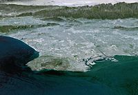
Los Angeles Basin
Los Angeles River
The Los Angeles River is a river that starts in the San Fernando Valley, in the Simi Hills and Santa Susana Mountains, and flows through Los Angeles County, California, from Canoga Park in the western end of the San Fernando Valley, nearly southeast to its mouth in Long Beach...
, San Gabriel
San Gabriel River (California)
The San Gabriel River flows through southern Los Angeles County, California in the United States. Its main stem is about long, while its farthest tributaries extend almost altogether...
, and Santa Ana River
Santa Ana River
The Santa Ana River is the largest river of Southern California in the United States. Its drainage basin spans four counties. It rises in the San Bernardino Mountains and flows past the cities of San Bernardino and Riverside, before cutting through the northern tip of the Santa Ana Mountains and...
s have deposited sediment from the Transverse Ranges along the southern coast of California. That sediment has formed the large, flat expanse of land known as the Los Angeles Basin
Los Angeles Basin
The Los Angeles Basin is the coastal sediment-filled plain located between the Peninsular and Transverse ranges in southern California in the United States containing the central part of the city of Los Angeles as well as its southern and southeastern suburbs...
, on which lives most of the population of Los Angeles and Orange
Orange County, California
Orange County is a county in the U.S. state of California. Its county seat is Santa Ana. As of the 2010 census, its population was 3,010,232, up from 2,846,293 at the 2000 census, making it the third most populous county in California, behind Los Angeles County and San Diego County...
Counties.
At its deepest point, near where the Los Angeles River meets the Rio Hondo
Rio Hondo (California)
The Rio Hondo is a tributary of the Los Angeles River in Los Angeles County, California, approximately long. As a named river, it begins in Irwindale and flows southwest to its confluence in South Gate, passing through several cities...
, the sediment forming the basin is 6 miles (10 km) deep. The fact that so much sediment, which is naturally less stable than other geologic formations, underlies Los Angeles and its environs is one of the reasons earthquake
Earthquake
An earthquake is the result of a sudden release of energy in the Earth's crust that creates seismic waves. The seismicity, seismism or seismic activity of an area refers to the frequency, type and size of earthquakes experienced over a period of time...
s are such a danger to the metropolitan area.
Mojave Desert
Desert
A desert is a landscape or region that receives an extremely low amount of precipitation, less than enough to support growth of most plants. Most deserts have an average annual precipitation of less than...
s in the Southeast of California. These deserts are caused by a combination of the cold offshore current, which limits evaporation, and the rain shadow
Rain shadow
A rain shadow is a dry area on the lee side of a mountainous area. The mountains block the passage of rain-producing weather systems, casting a "shadow" of dryness behind them. As shown by the diagram to the right, the warm moist air is "pulled" by the prevailing winds over a mountain...
of the mountains. The prevailing winds blow from the ocean inland. When the air passes over the mountains, adiabatic cooling causes most water in the air to rain on the mountains. When the air returns to sea level on the other side of the mountains, it recompresses, warms and dries, parching the deserts. When the wind blows from inland, the resulting hot dry foehn winds are called the Santa Ana Winds.
The Mojave Desert
Mojave Desert
The Mojave Desert occupies a significant portion of southeastern California and smaller parts of central California, southern Nevada, southwestern Utah and northwestern Arizona, in the United States...
is bounded by the peninsular Tehachapi Mountains on the Northwest, together with the San Gabriel and the San Bernardino Mountains on the Southwest. These Western boundaries are quite distinct, forming the dominant pie-slice shaped Antelope Valley in Southern California. The outlines of this valley are caused by the two largest faults in California: the San Andreas
San Andreas Fault
The San Andreas Fault is a continental strike-slip fault that runs a length of roughly through California in the United States. The fault's motion is right-lateral strike-slip...
and the Garlock
Garlock Fault
The Garlock Fault is a left-lateral strike-slip fault running approximately northeast-southwest in the Mojave Desert of southern California. It runs for much of its length along the southern base of the Tehachapi Mountains...
. The Mojave Desert extends Eastward into the State of Nevada
Nevada
Nevada is a state in the western, mountain west, and southwestern regions of the United States. With an area of and a population of about 2.7 million, it is the 7th-largest and 35th-most populous state. Over two-thirds of Nevada's people live in the Las Vegas metropolitan area, which contains its...
. The Mojave Desert receives less than 6 inches (150 mm) of rain a year and is generally between 3,000 and 6,000 feet (1,000 and 2,000 m) of elevation. Areas such as the Antelope Valley desert which is a high desert received snow each year, in the past it could snow 2-3 times a year; however, recently snow level has declined significantly to once a year or less. Most of the towns and cities in the California portion of the Mojave are relatively small, except for Palmdale
Palmdale, California
Palmdale is a city located in the center of northern Los Angeles County, California, United States.Palmdale was the first community within the Antelope Valley to incorporate as a city on August 24, 1962; 47 years later, voters approved creating a charter city in November, 2009. Palmdale is...
and Lancaster
Lancaster, California
Lancaster is a charter city in northern Los Angeles County, in the high desert, near the Kern County line. Lancaster currently ranks as the 30th largest city in California, and the 148th largest city in the United States. Lancaster is the principal city within the Antelope Valley...
. However, some are quite famous like Barstow
Barstow, California
Barstow is a city in San Bernardino County, California, United States. The population was 22,639 at the 2010 census, up from 21,119 at the 2000 census. Barstow is located north of San Bernardino....
, a popular stop on the famous U.S. Route 66
U.S. Route 66
U.S. Route 66 was a highway within the U.S. Highway System. One of the original U.S. highways, Route 66 was established on November 11, 1926 -- with road signs erected the following year...
. The Mojave Desert also contains the lowest, hottest place in the Americas
Americas
The Americas, or America , are lands in the Western hemisphere, also known as the New World. In English, the plural form the Americas is often used to refer to the landmasses of North America and South America with their associated islands and regions, while the singular form America is primarily...
: Death Valley
Death Valley National Park
Death Valley National Park is a national park in the U.S. states of California and Nevada located east of the Sierra Nevada in the arid Great Basin of the United States. The park protects the northwest corner of the Mojave Desert and contains a diverse desert environment of salt-flats, sand dunes,...
, where temperature normally approaches 120 °F (49 °C) in late July and early August.
Peninsular Ranges
The southernmost mountains of California are the Peninsular RangesPeninsular Ranges
The Peninsular Ranges are a group of mountain ranges, in the Pacific Coast Ranges, which stretch from southern California in the United States to the southern tip of Mexico's Baja California peninsula; they are part of the North American Coast Ranges that run along the Pacific coast from Alaska...
, which are East of San Diego
San Diego, California
San Diego is the eighth-largest city in the United States and second-largest city in California. The city is located on the coast of the Pacific Ocean in Southern California, immediately adjacent to the Mexican border. The birthplace of California, San Diego is known for its mild year-round...
and continue into Baja California
Baja California
Baja California officially Estado Libre y Soberano de Baja California is one of the 31 states which, with the Federal District, comprise the 32 Federal Entities of Mexico. It is both the northernmost and westernmost state of Mexico. Before becoming a state in 1953, the area was known as the North...
(Mexico
Mexico
The United Mexican States , commonly known as Mexico , is a federal constitutional republic in North America. It is bordered on the north by the United States; on the south and west by the Pacific Ocean; on the southeast by Guatemala, Belize, and the Caribbean Sea; and on the east by the Gulf of...
) in the Sierra San Pedro Martir
Sierra San Pedro Mártir
Sierra de San Pedro Mártir is a mountain range that is one of the Peninsular Ranges of the Baja California peninsula, Mexico. At , the highest peak is the Picacho del Diablo, also known as Cerro de la Encantada or Picacho la Providencia...
. The Peninsular Ranges contain the Laguna Mountains
Laguna Mountains
The Laguna Mountains are a section of the Peninsular Ranges in eastern San Diego County, California. The mountains run in a northwest/southeast alignment for approximately ....
, the San Jacinto Mountains
San Jacinto Mountains
The San Jacinto Mountains are a mountain range east of Los Angeles in southern California in the United States. The mountains are named for Saint Hyacinth . The Pacific Crest Trail runs along the spine of the range.The range extends for approximately from the San Bernardino Mountains southeast to...
, the Santa Rosa Mountains
Santa Rosa Mountains (California)
The Santa Rosa Mountains are a short mountain range in the Peninsular Ranges system, located east of the Los Angeles Basin and northeast of the San Diego metropolitan area of southern California, in the Southwestern United States.-Geography:...
, the Santa Ana Mountains
Santa Ana Mountains
The Santa Ana Mountains are a short peninsular mountain range along the coast of Southern California in the United States. They extend for approximately 36 mi southeast of the Los Angeles Basin largely along the border between Orange and Riverside counties.- Geography :The range starts in the...
and the Palomar Mountain Range
Palomar Mountain Range
The Palomar Mountain Range is a high Peninsular mountain range in northern San Diego County of Southern California. The name, which means pigeon roost in Spanish, was given to it due to the prevalence of Band-tailed Pigeons....
, notable for its famous Palomar observatory. San Jacinto Peak
San Jacinto Peak
San Jacinto Peak, 10,834 feet , is the highest peak of the San Jacinto Mountains, and of Riverside County, California. It lies within Mount San Jacinto State Park...
's eastern shoulder has a cable tram that runs from the desert floor to nearly the top of the mountain where riders can set off hiking
Hiking
Hiking is an outdoor activity which consists of walking in natural environments, often in mountainous or other scenic terrain. People often hike on hiking trails. It is such a popular activity that there are numerous hiking organizations worldwide. The health benefits of different types of hiking...
or go cross-country skiing
Cross-country skiing
Cross-country skiing is a winter sport in which participants propel themselves across snow-covered terrain using skis and poles...
.
Colorado Desert
To the east of the peninsular ranges lie the ColoradoColorado Desert
California's Colorado Desert is a part of the larger Sonoran Desert, which extends across southwest North America. The Colorado Desert region encompasses approximately , reaching from the Mexican border in the south to the higher-elevation Mojave Desert in the north and from the Colorado River in...
and Sonoran Desert
Sonoran Desert
The Sonoran Desert is a North American desert which straddles part of the United States-Mexico border and covers large parts of the U.S. states of Arizona and California and the northwest Mexican states of Sonora, Baja California, and Baja California Sur. It is one of the largest and hottest...
s, which extend into Arizona
Arizona
Arizona ; is a state located in the southwestern region of the United States. It is also part of the western United States and the mountain west. The capital and largest city is Phoenix...
and Mexico.
The ground elevation is generally lower and in some areas was compressed downward, therefore the eastern Coachella
Coachella Valley
Coachella Valley is a large valley landform in Southern California. The valley extends for approximately 45 miles in Riverside County southeast from the San Bernardino Mountains to the saltwater Salton Sea, the largest lake in California...
and Imperial Valley
Imperial Valley
The Imperial Valley is an agricultural area of Southern California's Imperial County. It is located in southeastern Southern California, centered around the city of El Centro. Locally, the terms "Imperial Valley" and "Imperial County" are used synonymously. The Valley is bordered between the...
s north of the U.S.-Mexican border are below sea level, the lowest community in the U.S. is Calipatria, California
Calipatria, California
Calipatria is a city in Imperial County, California. Calipatria is located north of El Centro, It is part of the El Centro Metropolitan Area. The population was 7,705 at the 2010 census, up from 7,289 at the 2000 census, including 4000 inmates at Calipatria State Prison...
at 160 feet (48.8 m) below sea level.
One feature of the desert is the Salton Sea
Salton Sea
The Salton Sea is a shallow, saline, endorheic rift lake located directly on the San Andreas Fault, predominantly in California's Imperial Valley. The lake occupies the lowest elevations of the Salton Sink in the Colorado Desert of Imperial and Riverside counties in Southern California. Like Death...
, an inland lake that was formed in 1905 when a swollen Colorado River breached a canal
Alamo Canal
The Alamo Canal was a long waterway that connected the Colorado River to the head of the Alamo River. The canal was constructed to provide irrigation to the Imperial Valley. A small portion of the canal was located in the United States but the majority of the canal was located in Mexico...
near the U.S.-Mexico border and flowed into the Salton Sink
Salton Sink
The Salton Sink is a geographic sink in the Coachella and Imperial valleys of southeastern California. It is in the Colorado Desert subregion of the Sonoran Desert ecoregion...
(Salton Basin) for almost two years. Today, the Salton Sea, a new version of historic Lake Cahuilla
Lake Cahuilla
Prehistoric Lake Cahuilla was an extensive freshwater lake that filled the Coachella, Imperial, and Mexicali valleys of southeastern California and northeastern Baja California during the centuries prior to Spanish entry into the region...
, remains as California's largest lake.
The Channel Islands and Palo Verdes
The Channel IslandsChannel Islands of California
The Channel Islands of California are a chain of eight islands located in the Pacific Ocean off the coast of Southern California along the Santa Barbara Channel in the United States of America...
are a group of island
Island
An island or isle is any piece of sub-continental land that is surrounded by water. Very small islands such as emergent land features on atolls can be called islets, cays or keys. An island in a river or lake may be called an eyot , or holm...
s off the coast
Coast
A coastline or seashore is the area where land meets the sea or ocean. A precise line that can be called a coastline cannot be determined due to the dynamic nature of tides. The term "coastal zone" can be used instead, which is a spatial zone where interaction of the sea and land processes occurs...
of Southern California. They are divided into two groups, the Northern Channel Islands and the Southern Channel Islands. There are eight islands total:
| Northern islands | Southern islands |
| Anacapa Island Anacapa Island Anacapa Island is a small volcanic island located about off the coast of Port Hueneme, California, in Ventura County. The Island is composed of a series of narrow islets six miles long, running in a mostly east-west orientation, five miles east of Santa Cruz Island... |
San Clemente Island San Clemente Island San Clemente Island is the southernmost of the Channel Islands of California. It is owned and operated by the United States Navy, and is a part of Los Angeles County. Defined by the United States Census Bureau as Block Group 2 of Census Tract 5991 of Los Angeles County, California, it is long and... |
| San Miguel Island San Miguel Island San Miguel Island is the westernmost of California's Channel Islands, located across the Santa Barbara Channel in the Pacific Ocean, within Santa Barbara County, California. San Miguel is the sixth-largest of the eight Channel Islands at , including offshore islands and rocks. Prince Island, off... |
San Nicolas Island San Nicolas Island San Nicolas Island is the most remote of California's Channel Islands. It is part of Ventura County. The 14,562 acre island is currently controlled by the United States Navy and is used as a weapons testing and training facility, served by Naval Outlying Field San Nicolas Island... |
| Santa Cruz Island Santa Cruz Island Santa Cruz Island was the largest privately owned island off the continental United States, but is currently part-owned by the National Park service . The island, located off the coast of California, is long and from wide... |
Santa Barbara Island Santa Barbara Island Santa Barbara Island is a small island of the Channel Islands archipelago in California. It is located about off the Southern California coast from the Palos Verdes Peninsula, near Los Angeles in Ventura County, California.... |
| Santa Rosa Island Santa Rosa Island, California Santa Rosa Island is the second largest of the Channel Islands of California at 53,195 acres . Defined by the United States Census Bureau as Block 3009, Block Group 3, Census Tract 29.10 of Santa Barbara County, California, the 2000 census showed an official population of 2 persons. It is part of... |
Santa Catalina Island Santa Catalina Island, California Santa Catalina Island, often called Catalina Island, or just Catalina, is a rocky island off the coast of the U.S. state of California. The island is long and across at its greatest width. The island is located about south-southwest of Los Angeles, California. The highest point on the island is... |
Four of the islands are located in Santa Barbara County
Santa Barbara County, California
Santa Barbara County is a county located in the southern portion of the U.S. state of California, on the Pacific coast. As of 2010 the county had a population of 423,895. The county seat is Santa Barbara and the largest city is Santa Maria.-History:...
, two are located in Ventura County
Ventura County, California
Ventura County is a county in the southern part of the U.S. state of California. It is located on California's Pacific coast. It is often referred to as the Gold Coast, and has a reputation of being one of the safest populated places and one of the most affluent places in the country...
, and two are located in Los Angeles County
Los Angeles County, California
Los Angeles County is a county in the U.S. state of California. As of 2010 U.S. Census, the county had a population of 9,818,605, making it the most populous county in the United States. Los Angeles County alone is more populous than 42 individual U.S. states...
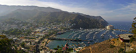
. The islands have relatively few people. The only island with a sizable settlement is Santa Catalina
Santa Catalina Island, California
Santa Catalina Island, often called Catalina Island, or just Catalina, is a rocky island off the coast of the U.S. state of California. The island is long and across at its greatest width. The island is located about south-southwest of Los Angeles, California. The highest point on the island is...
, with its towns of Avalon
Avalon, California
Avalon, or Avalon Bay, is the only incorporated city on Santa Catalina Island of the California Channel Islands, and the southernmost city in Los Angeles County. Besides Avalon, the only other center of population on the island is the small unincorporated town of Two Harbors...
and Two Harbors
Two Harbors, California
Two Harbors, colloquially known as "The Isthmus", is a small unincorporated island village on Santa Catalina Island, California with a population of 298 . It is the second center of population on the island, besides the city of Avalon. It is mainly a resort village. It has only one restaurant, one...
. The islands of Anacapa, San Miguel, Santa Barbara, Santa Cruz, and Santa Rosa make up the Channel Islands National Park
Channel Islands National Park
- External links :* Official site: * *...
. There is also a marine sanctuary in the islands, the Channel Islands National Marine Sanctuary
Channel Islands National Marine Sanctuary
The Channel Islands National Marine Sanctuary is a reserve area off the Pacific coast of the United States, near California.Established in 1980, the sanctuary in the Santa Barbara Channel is an area of national significance because of its exceptional natural beauty and resources. It has an area of...
. The Channel Islands, and in particular San Nicolas Island, are famous for the Lost Woman of San Nicolas, or Juana Maria
Juana Maria
Juana Maria , better known to history as the Lone Woman of San Nicolas Island , was a Native American woman who was the last surviving member of her tribe, the Nicoleño. She lived alone on San Nicolas Island from 1835 until her discovery in 1853...
. This woman was the main character in the book Island of the Blue Dolphins
Island of the Blue Dolphins
Island of the Blue Dolphins is a 1960 American children's novel written by Scott O'Dell. The story of a young girl stranded for years on an island off the California coast, it is based on the true story of Juana Maria, a Nicoleño Indian left alone for 18 years on San Nicolas Island in the 19th...
by Scott O’Dell.
The Palos Verdes
Palos Verdes
Palos Verdes is a name often used to refer to a group of coastal cities in the Palos Verdes Hills on the Palos Verdes Peninsula, within southwestern Los Angeles County in the U.S...
Peninsula has the same geologic origins as the Channel Islands. Once an island north of Santa Catalina, Palos Verdes is today connected to the mainland. Over millions of years, sediment from nearby mountains extended the shoreline of the Los Angeles Basin until it reached Palos Verdes.
Pacific Ocean
The Pacific OceanPacific Ocean
The Pacific Ocean is the largest of the Earth's oceanic divisions. It extends from the Arctic in the north to the Southern Ocean in the south, bounded by Asia and Australia in the west, and the Americas in the east.At 165.2 million square kilometres in area, this largest division of the World...
lies to the west of California. Sea temperatures rarely exceed 65 °F (18 °C), even in summer, because of up-welling
Upwelling
Upwelling is an oceanographic phenomenon that involves wind-driven motion of dense, cooler, and usually nutrient-rich water towards the ocean surface, replacing the warmer, usually nutrient-depleted surface water. The increased availability in upwelling regions results in high levels of primary...
deep waters with dissolved nutrients. Therefore, most sea life in and around California more closely resembles Arctic, rather than tropical, biotope
Biotope
Biotope is an area of uniform environmental conditions providing a living place for a specific assemblage of plants and animals. Biotope is almost synonymous with the term habitat, but while the subject of a habitat is a species or a population, the subject of a biotope is a biological community.It...
s. The sea off California is remarkably fertile, a murky green filled with fish, rather than the clear dead blue of most tropical seas. Before 1930, there was an extremely valuable sardine
Sardine
Sardines, or pilchards, are several types of small, oily fish related to herrings, family Clupeidae. Sardines are named after the Mediterranean island of Sardinia, around which they were once abundant....
(herring
Herring
Herring is an oily fish of the genus Clupea, found in the shallow, temperate waters of the North Pacific and the North Atlantic oceans, including the Baltic Sea. Three species of Clupea are recognized. The main taxa, the Atlantic herring and the Pacific herring may each be divided into subspecies...
) fishery off Monterey
Monterey, California
The City of Monterey in Monterey County is located on Monterey Bay along the Pacific coast in Central California. Monterey lies at an elevation of 26 feet above sea level. As of the 2010 census, the city population was 27,810. Monterey is of historical importance because it was the capital of...
, but this was depleted, an event later famous as the background to John Steinbeck
John Steinbeck
John Ernst Steinbeck, Jr. was an American writer. He is widely known for the Pulitzer Prize-winning novel The Grapes of Wrath and East of Eden and the novella Of Mice and Men...
's Cannery Row
Cannery Row (novel)
Cannery Row is an English language novel by American author John Steinbeck. It was published in 1945. A film version was released in 1982. A stage version was produced in 1995....
.
Faults
EarthquakeEarthquake
An earthquake is the result of a sudden release of energy in the Earth's crust that creates seismic waves. The seismicity, seismism or seismic activity of an area refers to the frequency, type and size of earthquakes experienced over a period of time...
s occur due to faults that run the length of the Pacific coast, the largest being the San Andreas
San Andreas Fault
The San Andreas Fault is a continental strike-slip fault that runs a length of roughly through California in the United States. The fault's motion is right-lateral strike-slip...
. Major historical earthquakes include:
- 1906 San Francisco earthquake1906 San Francisco earthquakeThe San Francisco earthquake of 1906 was a major earthquake that struck San Francisco, California, and the coast of Northern California at 5:12 a.m. on Wednesday, April 18, 1906. The most widely accepted estimate for the magnitude of the earthquake is a moment magnitude of 7.9; however, other...
- Sylmar earthquakeSylmar earthquakeThe 1971 San Fernando earthquake struck the San Fernando Valley near Sylmar, California at 6:00:55 a.m. PST on February 9, 1971, with a magnitude of 6.6....
(1971) - Loma Prieta earthquakeLoma Prieta earthquakeThe Loma Prieta earthquake, also known as the Quake of '89 and the World Series Earthquake, was a major earthquake that struck the San Francisco Bay Area of California on October 17, 1989, at 5:04 p.m. local time...
(1989) - Northridge earthquakeNorthridge earthquakeThe Northridge earthquake was a massive earthquake that occurred on January 17, 1994, at 04:31 Pacific Standard Time in Reseda, a neighborhood in the city of Los Angeles, California, lasting for about 10–20 seconds...
(1994)
Coastal cities are vulnerable to tsunami
Tsunami
A tsunami is a series of water waves caused by the displacement of a large volume of a body of water, typically an ocean or a large lake...
s from locally generated earthquakes as well as those elsewhere in the Pacific Ring of Fire
Pacific Ring of Fire
The Pacific Ring of Fire is an area where large numbers of earthquakes and volcanic eruptions occur in the basin of the Pacific Ocean. In a horseshoe shape, it is associated with a nearly continuous series of oceanic trenches, volcanic arcs, and volcanic belts and/or plate movements...
. The Great Chilean Earthquake
Great Chilean Earthquake
The 1960 Valdivia earthquake or Great Chilean Earthquake of Sunday, 22 May 1960 is to date the most powerful earthquake ever recorded on Earth, rating 9.5 on the moment magnitude scale...
tsunami (1960) killed one person and caused $500,000 to $1,000,000 dollars of damage in Los Angeles
Los Angeles, California
Los Angeles , with a population at the 2010 United States Census of 3,792,621, is the most populous city in California, USA and the second most populous in the United States, after New York City. It has an area of , and is located in Southern California...
, damaged harbors in many coastal cities, and flooded streets in Crescent City
Crescent City, California
Crescent City is the county seat and only incorporated city in Del Norte County, California. Named for the crescent-shaped stretch of sandy beach south of the city, Crescent City had a total population of 7,643 in the 2010 census, up from 4,006 in the 2000 census...
. Waves from the Alaskan Good Friday Earthquake
Good Friday Earthquake
The 1964 Alaska earthquake, also known as the Great Alaskan Earthquake, the Portage Earthquake and the Good Friday Earthquake, was a megathrust earthquake that began at 5:36 P.M. AST on Good Friday, March 27, 1964...
of 1964 killed twelve people in Crescent City and caused damage as far south as Los Angeles.
California is also home to several volcano
Volcano
2. Bedrock3. Conduit 4. Base5. Sill6. Dike7. Layers of ash emitted by the volcano8. Flank| 9. Layers of lava emitted by the volcano10. Throat11. Parasitic cone12. Lava flow13. Vent14. Crater15...
es, including Lassen Peak
Lassen Peak
Lassen Peak is the southernmost active volcano in the Cascade Range. It is part of the Cascade Volcanic Arc which is an arc that stretches from northern California to southwestern British Columbia...
, which erupted in 1914 and 1921, and Mount Shasta
Mount Shasta
Mount Shasta is located at the southern end of the Cascade Range in Siskiyou County, California and at is the second highest peak in the Cascades and the fifth highest in California...
.
Continental drift
California, when only partially explored by the Spanish, was once thought to be an island, as when the southern Baja California peninsulaBaja California Peninsula
The Baja California peninsula , is a peninsula in northwestern Mexico. Its land mass separates the Pacific Ocean from the Gulf of California. The Peninsula extends from Mexicali, Baja California in the north to Cabo San Lucas, Baja California Sur in the south.The total area of the Baja California...
is approached from the Gulf of California
Gulf of California
The Gulf of California is a body of water that separates the Baja California Peninsula from the Mexican mainland...
the land appears to the west. It is expected, through the motions of plate tectonics
Plate tectonics
Plate tectonics is a scientific theory that describes the large scale motions of Earth's lithosphere...
that the sea floor spreading now acting in the Gulf of California (also known as the Sea of Cortez) will eventually extend through Southern California and along the San Andreas fault to below San Francisco, finally forming a long island in less than 150 million years. (For comparison, this is also the approximate age of the Atlantic Ocean
Atlantic Ocean
The Atlantic Ocean is the second-largest of the world's oceanic divisions. With a total area of about , it covers approximately 20% of the Earth's surface and about 26% of its water surface area...
.) Predictions suggest that this island will eventually collide with Alaska
Alaska
Alaska is the largest state in the United States by area. It is situated in the northwest extremity of the North American continent, with Canada to the east, the Arctic Ocean to the north, and the Pacific Ocean to the west and south, with Russia further west across the Bering Strait...
after an additional 100 million years.
Climate
CaliforniaCalifornia
California is a state located on the West Coast of the United States. It is by far the most populous U.S. state, and the third-largest by land area...
's climate varies widely, from arid
Arid
A region is said to be arid when it is characterized by a severe lack of available water, to the extent of hindering or even preventing the growth and development of plant and animal life...
to subarctic
Subarctic
The Subarctic is a region in the Northern Hemisphere immediately south of the true Arctic and covering much of Alaska, Canada, the north of Scandinavia, Siberia, and northern Mongolia...
, depending on latitude
Latitude
In geography, the latitude of a location on the Earth is the angular distance of that location south or north of the Equator. The latitude is an angle, and is usually measured in degrees . The equator has a latitude of 0°, the North pole has a latitude of 90° north , and the South pole has a...
, elevation
Elevation
The elevation of a geographic location is its height above a fixed reference point, most commonly a reference geoid, a mathematical model of the Earth's sea level as an equipotential gravitational surface ....
, and proximity to the coast. Coastal and Southern parts of the state have a Mediterranean climate
Mediterranean climate
A Mediterranean climate is the climate typical of most of the lands in the Mediterranean Basin, and is a particular variety of subtropical climate...
, with somewhat rainy winters and dry summers. The influence of the ocean
Ocean
An ocean is a major body of saline water, and a principal component of the hydrosphere. Approximately 71% of the Earth's surface is covered by ocean, a continuous body of water that is customarily divided into several principal oceans and smaller seas.More than half of this area is over 3,000...
generally moderates temperature extremes, creating warmer winters and substantially cooler summers, especially along the coastal areas.
The state is subject to coastal storms during the winter. Eastern California is subject to summertime thunderstorms caused by the North American monsoon
North American Monsoon
The North American monsoon, variously known as the Southwest United States monsoon, the Mexican monsoon, or the Arizona monsoon, is experienced as a pronounced increase in rainfall from an extremely dry June to a rainy July over large areas of the southwestern United States and northwestern Mexico...
. Dry weather during the rest of the year produces conditions favorable to wildfire
Wildfire
A wildfire is any uncontrolled fire in combustible vegetation that occurs in the countryside or a wilderness area. Other names such as brush fire, bushfire, forest fire, desert fire, grass fire, hill fire, squirrel fire, vegetation fire, veldfire, and wilkjjofire may be used to describe the same...
s. California hurricanes occur less frequently than their counterparts on the Atlantic Ocean
Atlantic Ocean
The Atlantic Ocean is the second-largest of the world's oceanic divisions. With a total area of about , it covers approximately 20% of the Earth's surface and about 26% of its water surface area...
. Higher elevations experience snowstorms in the winter months.
Flood
Flood
A flood is an overflow of an expanse of water that submerges land. The EU Floods directive defines a flood as a temporary covering by water of land not normally covered by water...
s are occasionally caused by heavy rain, storms, and snowmelt. Steep slopes and unstable soil make certain locations vulnerable to landslides in wet weather or during earthquakes.
See also
- 4000 meter peaks of California
- Deserts of California
- Ecology of CaliforniaEcology of CaliforniaThe ecology of California is diverse: it is considered to span six biogeographic provinces or ecoregions: "Coastal Chaparral Forest and Shrub", "Dry Steppe", "Coastal Steppe, Mixed Forest, and Redwood Forest", "Sierran Steppe/Mixed Forest/Coniferous Forest", "Coastal Range Open Woodland/Shrub/...
- List of California fourteeners
- List of California state parks
- List of forts in California
- List of lakes in California
- List of mountain ranges of California
- List of regions of California
- List of rivers in California
- Mountain peaks of CaliforniaMountain peaks of CaliforniaThis article comprises three sortable tables of major mountain peaks of the U.S. State of California.Topographic elevation is the vertical distance above the reference geoid, a precise mathematical model of the Earth's sea level as an equipotential gravitational surface...
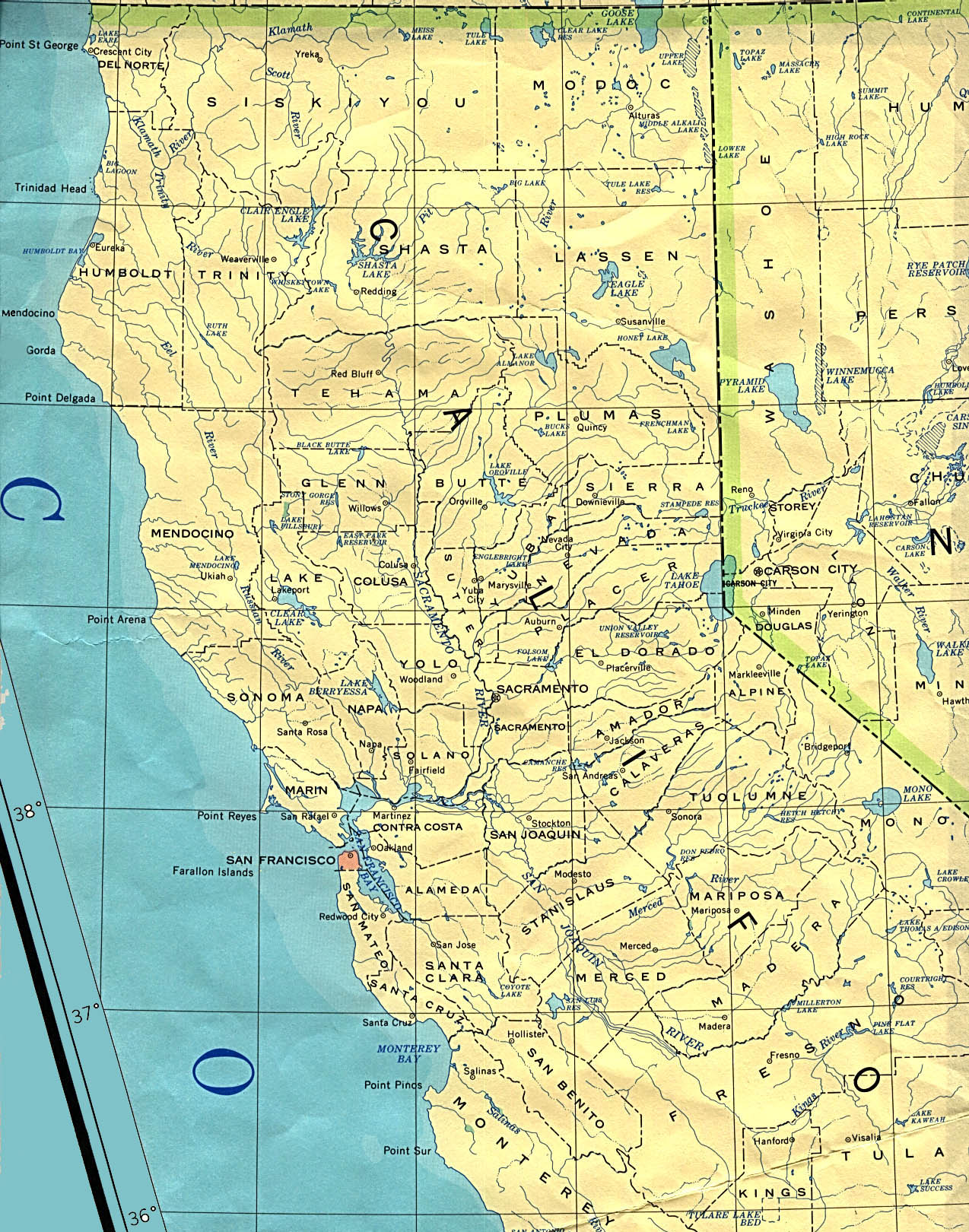
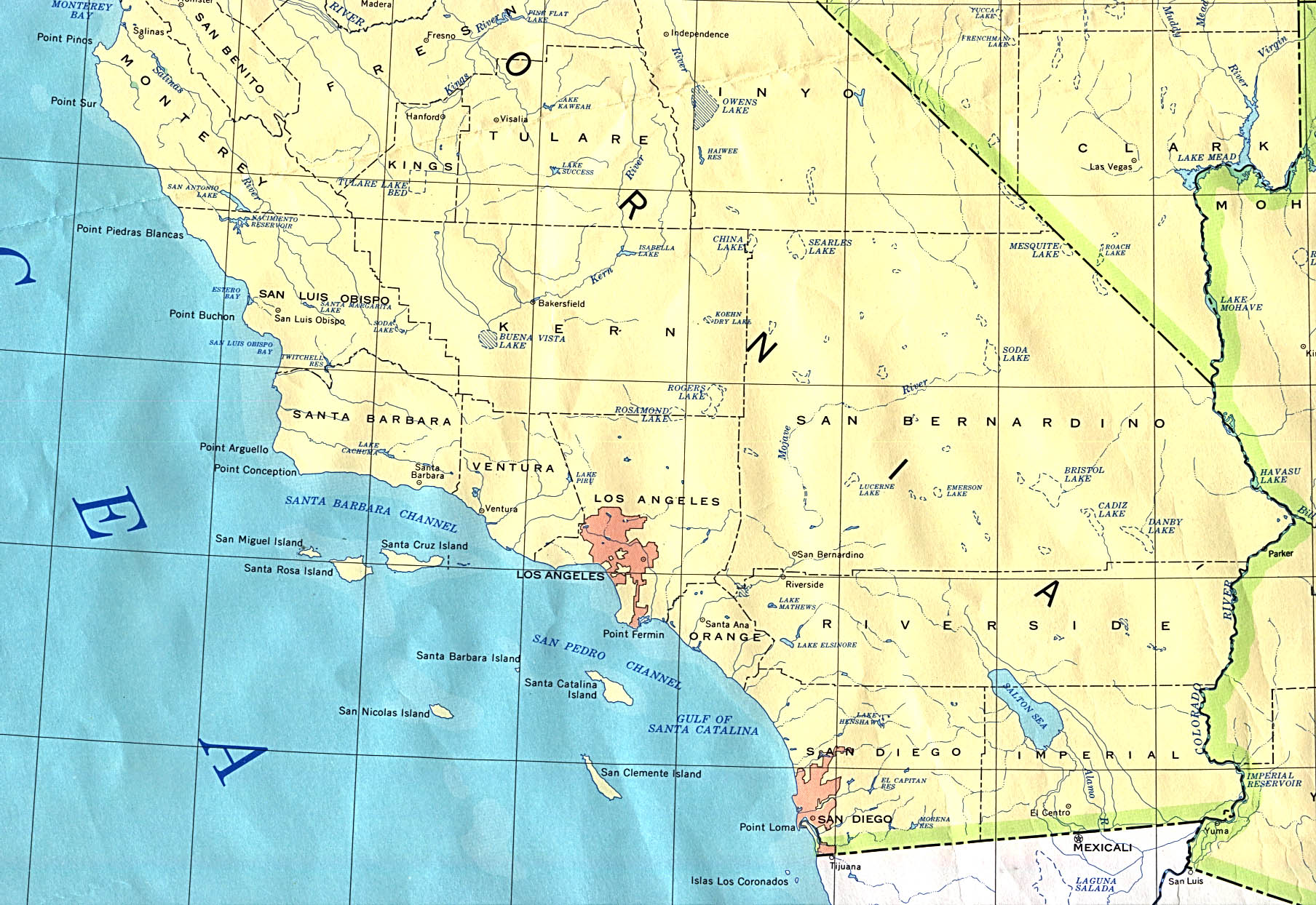