
Geography of Burundi
Encyclopedia
Africa
Africa is the world's second largest and second most populous continent, after Asia. At about 30.2 million km² including adjacent islands, it covers 6% of the Earth's total surface area and 20.4% of the total land area...
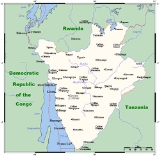
, to the east of the Democratic Republic of the Congo
Democratic Republic of the Congo
The Democratic Republic of the Congo is a state located in Central Africa. It is the second largest country in Africa by area and the eleventh largest in the world...
, at the co-ordinates 3°30′S 30°0′E.
Physical geography
BurundiBurundi
Burundi , officially the Republic of Burundi , is a landlocked country in the Great Lakes region of Eastern Africa bordered by Rwanda to the north, Tanzania to the east and south, and the Democratic Republic of the Congo to the west. Its capital is Bujumbura...
occupies an area equal to 27,830 square kilometres in size, of which 25,650 km² is land. The country has 974 kilometres of land border: 233 km of which is shared with the Democratic Republic of the Congo, 290 km with Rwanda
Rwanda
Rwanda or , officially the Republic of Rwanda , is a country in central and eastern Africa with a population of approximately 11.4 million . Rwanda is located a few degrees south of the Equator, and is bordered by Uganda, Tanzania, Burundi and the Democratic Republic of the Congo...
and 451 km with Tanzania
Tanzania
The United Republic of Tanzania is a country in East Africa bordered by Kenya and Uganda to the north, Rwanda, Burundi, and the Democratic Republic of the Congo to the west, and Zambia, Malawi, and Mozambique to the south. The country's eastern borders lie on the Indian Ocean.Tanzania is a state...
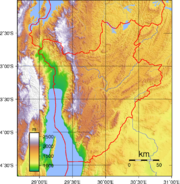
. As a landlocked country, Burundi possesses no coastline, although it straddles the crest of the Nile
Nile
The Nile is a major north-flowing river in North Africa, generally regarded as the longest river in the world. It is long. It runs through the ten countries of Sudan, South Sudan, Burundi, Rwanda, Democratic Republic of the Congo, Tanzania, Kenya, Ethiopia, Uganda and Egypt.The Nile has two major...
-Congo River
Congo River
The Congo River is a river in Africa, and is the deepest river in the world, with measured depths in excess of . It is the second largest river in the world by volume of water discharged, though it has only one-fifth the volume of the world's largest river, the Amazon...
watershed. The farthest headwaters of the Nile, the Ruvyironza River
Ruvyironza River
The Ruvyironza River is a river in Africa which is the most remote source of the Nile, the world's longest river. It rises in Burundi, and flows into the Kagera River in Tanzania, and from there into Lake Victoria.- References :...
, has its source in Burundi.
Climate
Burundi in general has a tropical highland climate, with a considerable daily temperature range in many areas. Temperature also varies considerably from one region to another, chiefly as a result of differences in altitude. The central plateau enjoys pleasantly cool weather, with an average temperature of 20 °C (68 °F). The area around Lake TanganyikaLake Tanganyika
Lake Tanganyika is an African Great Lake. It is estimated to be the second largest freshwater lake in the world by volume, and the second deepest, after Lake Baikal in Siberia; it is also the world's longest freshwater lake...
is warmer, averaging 23 °C (73.4 °F); the highest mountain areas are cooler, averaging 16 °C (60.8 °F). Bujumbura
Bujumbura
-Education:The University of Burundi is located in Bujumbura.Hope Africa University is located in BujumburaUniversité du Lac Tanganyika is located in Bujumbura-External links:**...
’s average annual temperature is
23 °C (73.4 °F). Rain is irregular, falling most heavily in the northwest. Dry seasons vary in length, and there are sometimes long periods of drought. However, four seasons can be distinguished: the long dry season (June–August), the short wet season (September–November), the short dry season (December–January), and the long wet season (February–May). Most of Burundi receives between 1300 and 1600 mm (51.2 and 63 in) of rainfall a year. The Ruzizi Plain and the northeast receive between 750 and 1000 mm (29.5 and 39.4 in).
Terrain
The terrain of Burundi is hilly and mountainMountain
Image:Himalaya_annotated.jpg|thumb|right|The Himalayan mountain range with Mount Everestrect 58 14 160 49 Chomo Lonzorect 200 28 335 52 Makalurect 378 24 566 45 Mount Everestrect 188 581 920 656 Tibetan Plateaurect 250 406 340 427 Rong River...
ous, dropping to a plateau in the east. The southern and eastern plain
Plain
In geography, a plain is land with relatively low relief, that is flat or gently rolling. Prairies and steppes are types of plains, and the archetype for a plain is often thought of as a grassland, but plains in their natural state may also be covered in shrublands, woodland and forest, or...
s have been categorised by the World Wildlife Fund as part of the Central Zambezian Miombo woodlands
Central Zambezian Miombo woodlands
The densely forested Central Zambezian Miombo woodlands that cut across southern central Africa are one of the largest ecozones on the continent and home to a great variety of wildlife including many large mammals.-Location and description:...
ecoregion.
The lowest point in the country is at Lake Tanganyika
Lake Tanganyika
Lake Tanganyika is an African Great Lake. It is estimated to be the second largest freshwater lake in the world by volume, and the second deepest, after Lake Baikal in Siberia; it is also the world's longest freshwater lake...
, at 772 m, with the highest point being on Mount Heha
Mount Heha
Mount Heha is the highest mountain in Burundi and the highest point in the Burundi Highlands mountain range. It is located in the Bujumbura Rural province of Burundi and it lies approximately 20 km to the east of Lake Tanganyika and about 30 km to the southeast of Bujumbura, the capital of Burundi....
, at 2,684 m. Natural hazards are posed in Burundi by flooding and landslides.
Natural resources
Burundi possesses reserves of: nickelNickel
Nickel is a chemical element with the chemical symbol Ni and atomic number 28. It is a silvery-white lustrous metal with a slight golden tinge. Nickel belongs to the transition metals and is hard and ductile...
, uranium
Uranium
Uranium is a silvery-white metallic chemical element in the actinide series of the periodic table, with atomic number 92. It is assigned the chemical symbol U. A uranium atom has 92 protons and 92 electrons, of which 6 are valence electrons...
, rare earth oxides, peat
Peat
Peat is an accumulation of partially decayed vegetation matter or histosol. Peat forms in wetland bogs, moors, muskegs, pocosins, mires, and peat swamp forests. Peat is harvested as an important source of fuel in certain parts of the world...
, cobalt
Cobalt
Cobalt is a chemical element with symbol Co and atomic number 27. It is found naturally only in chemically combined form. The free element, produced by reductive smelting, is a hard, lustrous, silver-gray metal....
, copper
Copper
Copper is a chemical element with the symbol Cu and atomic number 29. It is a ductile metal with very high thermal and electrical conductivity. Pure copper is soft and malleable; an exposed surface has a reddish-orange tarnish...
, platinum
Platinum
Platinum is a chemical element with the chemical symbol Pt and an atomic number of 78. Its name is derived from the Spanish term platina del Pinto, which is literally translated into "little silver of the Pinto River." It is a dense, malleable, ductile, precious, gray-white transition metal...
(not yet exploited) and vanadium
Vanadium
Vanadium is a chemical element with the symbol V and atomic number 23. It is a hard, silvery gray, ductile and malleable transition metal. The formation of an oxide layer stabilizes the metal against oxidation. The element is found only in chemically combined form in nature...
. There is also arable land and the potential for hydropower. 140 km² of land in Burundi is irrigated. The table below describes land use in Burundi.
| Use | Percentage of Area |
|---|---|
| arable land | 35.57 |
| permanent crops | 13.12 |
| other | 51.31 |
Current issues
Soil erosion is an issue for Burundi, and is as a result of overgrazing and the expansion of agriculture into marginal lands. Other issues include: deforestation, due to the uncontrolled cutting-down of trees for fuel; and habitat loss threatens wildlife populations.International agreements
Burundi is a party to the following international agreements that relate to the environment: Biodiversity, Climate Change, Desertification, Endangered Species, Hazardous Wastes and Ozone Layer Protection. The following have been signed but not yet ratified by Burundi: Law of the Sea and Nuclear Test Ban.Extreme points
This is a list of the extreme points of BurundiBurundi
Burundi , officially the Republic of Burundi , is a landlocked country in the Great Lakes region of Eastern Africa bordered by Rwanda to the north, Tanzania to the east and south, and the Democratic Republic of the Congo to the west. Its capital is Bujumbura...
, the points that are farther north, south, east or west than any other location.
- Northernmost point - unnamed location on the border with RwandaRwandaRwanda or , officially the Republic of Rwanda , is a country in central and eastern Africa with a population of approximately 11.4 million . Rwanda is located a few degrees south of the Equator, and is bordered by Uganda, Tanzania, Burundi and the Democratic Republic of the Congo...
immediately south of the Rwandna town of Mbuye, Muyinga ProvinceMuyinga ProvinceMuyinga is one of the 17 provinces of Burundi.... - Easternmost point - unnamed location on the border with TanzaniaTanzaniaThe United Republic of Tanzania is a country in East Africa bordered by Kenya and Uganda to the north, Rwanda, Burundi, and the Democratic Republic of the Congo to the west, and Zambia, Malawi, and Mozambique to the south. The country's eastern borders lie on the Indian Ocean.Tanzania is a state...
immediately northwest of Mburi hill, Cankuzo ProvinceCankuzo ProvinceCankuzo is one of the 17 provinces of Burundi. Located in the eastern part of the country, the province covers an area of 1,965 km². The provincial capital is Cankuzo.-Communes:... - Southernmost point - unnamed location on the border with TanzaniaTanzaniaThe United Republic of Tanzania is a country in East Africa bordered by Kenya and Uganda to the north, Rwanda, Burundi, and the Democratic Republic of the Congo to the west, and Zambia, Malawi, and Mozambique to the south. The country's eastern borders lie on the Indian Ocean.Tanzania is a state...
immediately north of the Tanzanian town of Mwenene, Makamba ProvinceMakamba ProvinceMakamba is the southernmost province of Burundi. The province has a population of 357,492 and covers an area of 1,960 km². The provincial capital is Makamba.makamba has six communes. Many refugees have returned from Tanzania to this province, especially to the communes of Kayogoro, Nyanza lac,... - Westernmost point - unnamed location on the border the Democratic Republic of the CongoDemocratic Republic of the CongoThe Democratic Republic of the Congo is a state located in Central Africa. It is the second largest country in Africa by area and the eleventh largest in the world...
immediately east of the Congolese town of Kamanyola, Cibitoke ProvinceCibitoke ProvinceCibitoke is one of the 17 provinces of Republic of Burundi....